Friday, September 30, 2011

Typhoon NALGAE [QUIEL] - Update #006A


for Friday, 30 September 2011 [9:50 PM PhT]

click to get RSS data


<<<Typhoon2000.com Mobile >>>
Get the latest 6-hrly SMS Storm Alerts on QUIEL!
For more details: Text T2K TYPHOON to

2800 (Globe/TM) | 216 (Smart/TNT) | 2288 (Sun)
*Only P2.50 (Smart/Globe) / P2.00 (Sun) per msg received.

Click here on how to use this service (in PDF file)
Powered by: Synermaxx Corporation
Typhoon2000 (T2K) NEWS (Wednesday Sep 28 2011):

Currently issuing 6-hrly web, email, & android (iTyphoon) updates (except 12:00 Midnight) on NALGAE (QUIEL).


NALGAE (QUIEL) MAX WIND SPEED PER AGENCY:

+ USA (JTWC/1-min avg): 195 km/hr
+ Japan (JMA/10-min avg): 150 km/hr
+ Philippines (PAGASA/10-min avg): 140 km/hr
+ Beijing (NMC/2-min avg): 140 km/hr
+ Taiwan (CWB/10-min avg): 145 km/hr
+ Korea (KMA/10-min avg): 150 km/hr

+ Hong Kong (HKO/10-min avg): 120 km/hr
:: Click here to see Multi-Agency Forecast Tracks


TYPHOON NALGAE [QUIEL/22W/1119]
T2K INTERMEDIATE PUBLIC ADVISORY NUMBER 006A

9:00 PM PhT (13:00 GMT) Fri 30 September 2011
Source: T2K Analysis/JTWC TC Warning #013/SatFixes
View: Advisory Archives (2004-2011)
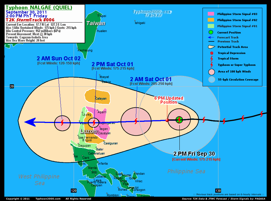
NALGAE (QUIEL) grows into a Category 3 Typhoon without any track change. Landfall expected along Isabela-Cagayan Border in 15 hours.

Projected Landfall Area (PLA): Along Cagayan-Isabela Border...just north of Divilacan Bay on or before 12 Noon local time Saturday.

Residents and visitors along Northern Luzon should closely monitor the progress of NALGAE (QUIEL).

Do not use this for life or death decision. This advisory is intended for additional information purposes only. Kindly refer to your country's official weather agency for local warnings, advisories & bulletins.


CURRENT STORM INFORMATION


Time/Date: 9:00 PM PhT Fri September 30 2011
Location of Eye: 17.6º N Lat 125.3º E Lon
Distance 1: 382 km East of Tuguegarao City
Distance 2: 374 km ENE of Ilagan City
Distance 3: 374 km ENE of Casiguran, Aurora
Distance 4: 390 km ENE of Cauayan, Isabela
Distance 5: 391 km ESE of Aparri, Cagayan
Distance 6: 502 km ESE of Laoag City
Distance 7: 519 km East of Vigan City
Distance 8: 559 km NE of Metro Manila
MaxWinds (1-min avg): 195 kph (105 kts) near the center
Peak Wind Gusts: 240 kph (130 kts)
Present Movement: West @ 30 kph (16 kts)
Towards: Cagayan-Isabela Area
24hr Rainfall Accum (near center): 350 mm (High)
Rainrate (near center): 20-30 mm/hr (Mod-Heavy)
Minimum Central Pressure: 944 millibars (hPa)
Saffir-Simpson Typhoon Scale: Category 3
Size (in Diameter): 630 km (340 nm) [Average]
Wind Area Distribution (in Knots): Current Wind Profile
Max Sea Wave Height (near center): 24 ft
Possible Storm Surge Height: 9-12 ft [2.7-3.9 m]
T2K TrackMap (for Public): 6 PM PhT Fri Sep 30

_____________________________________________________________________________

NOTE:

>> To know the meteorological terminologies and acronyms used on this update visit the ff:

   
http://typhoon2000.ph/tcterm.htm  
   
http://www.nhc.noaa.gov/aboutgloss.shtml
    http://www.nhc.noaa.gov/acronyms.shtml
__________________________________________________________________________________________

For the complete details on TY NALGAE (QUIEL)...go visit our website @:

>
http://www.typhoon2000.com
http://www.maybagyo.com

:: Kindly view our site's disclaimer at: 
   
http://www.typhoon2000.ph/disclaimer.htm


Copyright © 2011 Typhoon2000.com     All Rights Reserved

__._,_.___
Recent Activity:
MARKETPLACE

Stay on top of your group activity without leaving the page you're on - Get the Yahoo! Toolbar now.

.

__,_._,___

Typhoon NALGAE [QUIEL] - Update #006


for Friday, 30 September 2011 [6:50 PM PhT]

click to get RSS data


<<<Typhoon2000.com Mobile >>>
Get the latest 6-hrly SMS Storm Alerts on QUIEL!
For more details: Text T2K TYPHOON to

2800 (Globe/TM) | 216 (Smart/TNT) | 2288 (Sun)
*Only P2.50 (Smart/Globe) / P2.00 (Sun) per msg received.

Click here on how to use this service (in PDF file)
Powered by: Synermaxx Corporation
Typhoon2000 (T2K) NEWS (Wednesday Sep 28 2011):

Currently issuing 6-hrly web, email, & android (iTyphoon) updates (except 12:00 Midnight) on NALGAE (QUIEL).


NALGAE (QUIEL) MAX WIND SPEED PER AGENCY:

+ USA (JTWC/1-min avg): 175 km/hr
+ Japan (JMA/10-min avg): 150 km/hr
+ Philippines (PAGASA/10-min avg): 140 km/hr
+ Beijing (NMC/2-min avg): 140 km/hr
+ Taiwan (CWB/10-min avg): 145 km/hr
+ Korea (KMA/10-min avg): 150 km/hr

+ Hong Kong (HKO/10-min avg): 120 km/hr
:: Click here to see Multi-Agency Forecast Tracks


TYPHOON NALGAE [QUIEL/22W/1119]
T2K PUBLIC ADVISORY NUMBER 006

6:00 PM PhT (10:00 GMT) Fri 30 September 2011
Source: T2K Analysis/JTWC TC Warning #013/SatFixes
View: Advisory Archives (2004-2011)
The intensifying Typhoon NALGAE (QUIEL) rapidly moving westward...endangers Cagayan & Isabela. Landfall expected along Isabela-Cagayan Border in 18 hours.

Projected Landfall Area (PLA): Along Cagayan-Isabela Border...just north of Divilacan Bay on or before 12 Noon local time Saturday.

Residents and visitors along Northern Luzon should closely monitor the progress of NALGAE (QUIEL).

Do not use this for life or death decision. This advisory is intended for additional information purposes only. Kindly refer to your country's official weather agency for local warnings, advisories & bulletins.


CURRENT STORM INFORMATION

Time/Date: 6:00 PM PhT Fri September 30 2011
Location of Eye: 17.7º N Lat 126.3º E Lon
Distance 1: 487 km East of Tuguegarao City
Distance 2: 480 km ENE of Ilagan City
Distance 3: 496 km ENE of Cauayan, Isabela
Distance 4: 492 km ESE of Aparri, Cagayan
Distance 5: 477 km ENE of Casiguran, Aurora
Distance 6: 605 km ESE of Laoag City
Distance 7: 625 km East of Vigan City
Distance 8: 660 km NE of Metro Manila
MaxWinds (1-min avg): 175 kph (95 kts) near the center
Peak Wind Gusts: 215 kph (115 kts)
Present Movement: West @ 30 kph (16 kts)
Towards: Cagayan-Isabela Area
24hr Rainfall Accum (near center): 350 mm (High)
Rainrate (near center): 20-30 mm/hr (Mod-Heavy)
Minimum Central Pressure: 952 millibars (hPa)
Saffir-Simpson Typhoon Scale: Category 2
Size (in Diameter): 610 km (330 nm) [Average]
Wind Area Distribution (in Knots): Current Wind Profile
Max Sea Wave Height (near center): 24 ft
Possible Storm Surge Height: 6-8 ft [1.8-2.6 m]
T2K TrackMap (for Public): 6 PM PhT Fri Sep 30


3-DAY FORECAST OUTLOOK & ANALYSIS*

NALGAE (QUIEL) will continue to move generally westward (known in meteorology as a "Straight-Runner") throughout the forecast period...with a decrease in its forward speed. On the forecast track, the small core of the typhoon will make landfall along Cagayan-Isabela Border on or before noontime Saturday...and cross Northern Luzon in the afternoon through the early evening. NALGAE will move out of Northern Luzon via Ilocos Sur Sunday evening...and will be over the West Philippine Sea (South China Sea) Sunday morning. By early Monday, NALGAE will move out of the Philippine Area of Responsibility (PAR), on its way to Hainan Island, Southern China.

Maximum Sustained Winds (1-min. avg) have increased to near 175 km/hr (95 knots) with higher gusts. Additional strengthening is forecast during the next 12 to 18 hours, before making landfall over Northern Luzon...and NALGAE could become a Category 3 Typhoon tonight or early Saturday. This cyclone is now a Category 2 Typhoon on the Saffir-Simpson Tropical Cyclone Scale.

Typhoon Force Winds (118 km/hr or more) extend outward up to 65 kilometers (35 nautical miles) from the center...and Tropical Storm Force Winds (62-117 km/hr) extend outward up to 220 kilometers (120 nautical miles). NALGAE is an average-sized tropical cyclone with a diameter of 610 kilometers (330 nautical miles).

The following is the summary of the 3-day forecast outlook on this system:

SATURDAY AFTERNOON:  Crossing Northern Luzon...weakens to a Category 2 Typhoon...34 km WSW of Tuguegarao City [2PM OCT 01: 17.5N 121.4E @ 175kph].
SUNDAY AFTERNOON:  Weakens to Category 1 as it moves across the West Philippine Sea (aka. South China Sea)...350 km West of Vigan City, Ilocos Sur [2PM OCT 02: 17.6N 117.1E @ 130kph].
MONDAY AFTERNOON:  Maintains its strength...exits the Philippine Area of Responsibility (PAR) on its way towards Southern China [2PM OCT 03: 17.9N 113.2E @ 130kph].


NALGAE's (QUIEL) CLOSEST POINT OF APPROACH (CPA)*

ISABELA-CAGAYAN BORDER:  Passing over the boundary...[ETA: 10:00 AM-12:00 PM Local Time, Saturday].
SOUTHERN CAGAYAN:  Passing near/over Tuguegarao City [ETA: 12:00-2:00 PM Saturday].
ILOCOS SUR:  Passing near/over Vigan City [ETA: 4:00-6:00 PM Saturday].

*Please be reminded that the Forecast Outlook changes every 6 hours, and the Day 3 Forecast Track have an average error of 250 km...while the wind speed forecast error, averages 35 kph per day. Therefore, a turn to the left or right of its future track and changes in its wind speed must be anticipated from time to time.


EFFECTS & HAZARDS SUMMARY

NALGAE's (QUIEL's) compact & but intense circulation getting stronger with a small, pin-hole eye emerging on satellite imageries awhile ago. Below is the summary of the storm's parts and its hazards affecting specific areas:

CLOUD-FILLED EYE - over water (North Philippine Sea)...expected to landfall off the shores of Cagayan-Isabela Border on or before 12 noon Saturday. Possible calm and lull conditions (with <20 kph winds) will be expected inside the eye (click here to know more about the EYE).
EYEWALL - over water (North Philippine Sea)...expected to reach the shores of Cagayan-Isabela Border Saturday morning. Typhoon Conditions with Typhoon Force Winds (>118 kph) will be expected within this wall (click here to know more about the Eyewall).
INNER RAINBANDS - over water (North Philippine Sea)...not yet affecting any land areas...but will approach the coastal areas of Isabela & Cagayan Saturday early morning. Tropical Storm Conditions w/ Tropical Storm Force Winds (62-117 kph) will be expected along these bands.
OUTER RAINBANDS - over water (North Philippine Sea)...not yet affecting any land areas...however its western outer rainbands will reach Cagayan, Isabela, Batanes-Calayan-Babuyan Islands, & Aurora later tonight. Tropical Depression Conditions w/ moderate to strong winds (25-61 kph) will be expected along these bands (click here to know more about Rainbands).
24HR TOTAL RAINFALL ACCUMULATION - from 5 up to 100 mm (low to high rainfall) can be expected along areas affected by the outer & inner rainbands (see above)...with isolated amounts of 101 to 350 mm (high) along areas near the center of NALGAE (QUIEL). (click to open NOAA's eTRaP graphic).
COASTAL STORM SURGE FLOODING - possible 6-8 ft [1.8-2.6 m] above normal tide levels...accompanied by large and dangerous battering waves can be expected along the coastal and beach front areas of Northeastern Luzon beginning tonight or early Saturday. Minimal damage is likely on this type of storm surge. Danger from Rip Currents or Rip Tides can be expected along the beach-front areas of Luzon.
(click here to know more about Storm Surge).


TROPICAL CYCLONE WATCH

Tropical Disturbance 90W (LPA) quasi-stationary NNE of Palau...east of Mindanao. Its developing center was located about 1156 km ESE of Surigao City (9.0N 136.0E)...maximum sustained winds of 35 kph. The 24-hour TC Formation Potential is now at MEDIUM (40%).

Important Note: Please keep in mind that the above forecast outlook, effects-hazards, current monsoon intensity, & tropical cyclone watch changes every 6 to 12 hrs!


PAGASA Philippine Storm Warnings Signals

PHILIPPINE STORM SIGNAL # THREE (3) click to know meaning
Now In Effect:
CAGAYAN & ISABELA.

PHILIPPINE STORM WARNING SIGNAL # TWO (2) click to know meaning
Now In Effect:
NORTHERN AURORA, QUIRINO, IFUGAO, MT. PROVINCE, KALINGA, APAYAO, CALAYAN & BABUYAN GROUP OF ISLANDS.

The above areas will experience stormy weather beginning Saturday (with winds not exceeding 100 kph for #02 and 100-185 kph for #03). Coastal waters will be rough to very rough and extremely dangerous to all types of seacrafts.

PHILIPPINE STORM WARNING SIGNAL # ONE (1) click to know meaning
In Effect: REST OF AURORA, NUEVA VIZCAYA, PANGASINAN, BENGUET, LA UNION, ILOCOS NORTE, ILOCOS PROVINCES, & ABRA.

The above areas will have rains and winds of not more than 60 kph beginning late tonight. Coastal waters will be moderate to rough.

Residents living in low-lying and mountainous areas under Public Storm Warning Signals are alerted against flashfloods, mudslides and landslides...while those living in coastal & beach-front areas are advised to seek higher grounds due to possible storm surge (aka. big waves).


External Links for TY NALGAE (QUIEL)

PAGASA@Twitter: Hourly Updates
View NOAA-CIRA's: Latest Full Wind Analysis
JTWC Latest Tracking Chart: wp2211.gif
Multi-Agency Forecast TrackMap: Near Real-Time
TSR Wind Probabilities: Current to 5 Days Ahead
JAXA TRMM Page: Latest Rainrate (in mm/hr)
Zoomed Satellite Pic: NOAA's Near Real-Time
Wunderground Animation: 6-12 hr. GIF Loop

_____________________________________________________________________________

TYPHOON2000 CURRENT STORMTRACK:


_____________________________________________________________________________

NOTE:

>> To know the meteorological terminologies and acronyms used on this update visit the ff:

   
http://typhoon2000.ph/tcterm.htm  
   
http://www.nhc.noaa.gov/aboutgloss.shtml
    http://www.nhc.noaa.gov/acronyms.shtml
__________________________________________________________________________________________

For the complete details on TY NALGAE (QUIEL)...go visit our website @:

>
http://www.typhoon2000.com
http://www.maybagyo.com

:: Kindly view our site's disclaimer at: 
   
http://www.typhoon2000.ph/disclaimer.htm


Copyright © 2011 Typhoon2000.com     All Rights Reserved

__._,_.___
Recent Activity:
MARKETPLACE

Stay on top of your group activity without leaving the page you're on - Get the Yahoo! Toolbar now.

.

__,_._,___

TS NESAT [PEDRING] - Update #024


for Friday, 30 September 2011 [4:30 PM PhT]

click to get RSS data


<<<Typhoon2000.com Mobile >>>
Get the latest SMS Storm Alerts!
For more details: Text T2K HELP to

2800 (Globe/TM) | 216 (Smart/TNT) | 2288 (Sun)
*Only P2.50 (Smart/Globe) / P2.00 (Sun) per msg received.

Click here on how to use this service (in PDF file)
Powered by: Synermaxx Corporation
Typhoon2000 (T2K) NEWS (Wednesday Sep 28 2011):

Currently issuing 6-hrly web, email, & android (iTyphoon) updates (except 12:00 Midnight) on NESAT (PEDRING).


NESAT (PEDRING) MAX WIND SPEED PER AGENCY:

+ USA (JTWC/1-min avg): 100 km/hr
+ Japan (JMA/10-min avg): 85 km/hr
+ Philippines (PAGASA/10-min avg): --- km/hr
+ Beijing (NMC/2-min avg): 105 km/hr
+ Taiwan (CWB/10-min avg): 85 km/hr
+ Korea (KMA/10-min avg): 90 km/hr

+ Hong Kong (HKO/10-min avg): 85 km/hr
:: Click here to see Multi-Agency Forecast Tracks


TROPICAL STORM NESAT [PEDRING/20W/1117]
T2K PUBLIC ADVISORY NUMBER 024

2:00 PM PhT (06:00 GMT) Fri 30 September 2011
Source: T2K Analysis/JTWC TC Warning #028/SatFixes
View: Advisory Archives (2004-2011)
Tropical Storm NESAT (PEDRING) making landfall over Northern Vietnam...likely to dissipate over land within 24 hours.

Residents and visitors along Northern Vietnam & Laos should closely monitor the progress of NESAT (PEDRING).

Do not use this for life or death decision. This advisory is intended for additional information purposes only. Kindly refer to your country's official weather agency for local warnings, advisories & bulletins.


CURRENT STORM INFORMATION

Time/Date: 2:00 PM PhT Fri September 30 2011
Location of Center: 21.0º N Lat 106.6º E Lon
Distance 1: 83 km East of Hanoi, Vietnam
Distance 2: 307 km WNW of Hainan Island
MaxWinds (1-min avg): 100 kph (55 kts) near the center
Peak Wind Gusts: 130 kph (70 kts)
Present Movement: West @ 22 kph (12 kts)
Towards: Northern Vietnam
24hr Rainfall Accum (near center): 200 mm (VHigh)
Rainrate (near center): 20-25 mm/hr (Moderate)
Minimum Central Pressure: 982 millibars (hPa)
Saffir-Simpson Typhoon Scale: Tropical Storm
Size (in Diameter): 500 km (270 nm) [Large]
Wind Area Distribution (in Knots): Current Wind Profile
Max Sea Wave Height (near center): 18 ft
Possible Storm Surge Height: 1-3 ft [0.3-0.9 m]
Wunder TrackMap (for Public): 2 PM HKT Fri Sep 30


24-HOUR FORECAST OUTLOOK & ANALYSIS*

NESAT (PEDRING) will continue to move generally westward throughout the forecast period. On the forecast track, the core of the storm will pass over/near Hanoi City tonight...dissipating completely into a remnant Low on Saturday afternoon.

Maximum Sustained Winds (1-min. avg) are near 100 km/hr (55 knots) with higher gusts. NESAT is a strong Tropical Storm on the Saffir-Simpson Tropical Cyclone Scale. NESAT will weaken to a Tropical Depression Saturday & dissipate due to the topographical effects of Northern Vietnam.

The following is the summary of the 24-hour forecast outlook on this system:

SATURDAY EARLY MORNING:  Continues to traverse Northern Vietnam...decaying over land [2AM OCT 01: 21.1N 105.2E @ 85kph].
SATURDAY AFTERNOON:  Dissipated along the western portion of Northern Vietnam...just remnant low pressure [2PM OCT 01: 21.2N 103.6E @ 35kph].

*Please be reminded that the Forecast Outlook changes every 6 hours, and the Day 3 Forecast Track have an average error of 250 km...while the wind speed forecast error, averages 35 kph per day. Therefore, a turn to the left or right of its future track and changes in its wind speed must be anticipated from time to time.


EFFECTS & HAZARDS SUMMARY

NESAT's (PEDRING) decaying circulation bringing stormy weather across Northern Vietnam. Below is the summary of the storm's parts and its hazards affecting specific areas:

CENTRAL DENSE OVERCAST (CDO) - over the coastal area of Northern Vietnam...possible "Eye" forming underneath the cirrus canopy. Near-Typhoon Conditions w/ Near-Typhoon Force Winds (100-130 kph) will be expected along the CDO. (click here to know more about CDO).
INNER RAINBANDS - spreading and affecting the other portions of Northern Vietnam, Laos, & the coastal areas of SW Guangdong & the Gulf of Tonkin. Tropical Storm Conditions w/ Tropical Storm Force Winds (62-99 kph) will be expected along these bands.
OUTER RAINBANDS - spreading & affecting Hainan Island & Central Vietnam. Tropical Depression Conditions w/ moderate to strong winds (25-61 kph) will be expected along these bands (click here to know more about Rainbands).
24HR TOTAL RAINFALL ACCUMULATION - from 5 up to 150 mm (low to high rainfall) can be expected along areas affected by the outer & inner rainbands (see above)...with isolated amounts of 151 to 200 mm (high) along areas near the center of NESAT (PEDRING). (click to open NOAA's eTRaP graphic).
COASTAL STORM SURGE FLOODING - possible 1-3 ft [0.3-0.9 m] above normal tide levels...accompanied by large and dangerous battering waves can be expected along the coastal and beach front areas of Southwestern Guangdong & Northern Vietnam. Minimal damage is likely on this type of storm surge. Danger from Rip Currents or Rip Tides can be expected along the beach-front areas of Vietnam, Southern China & Western Luzon.
(click here to know more about Storm Surge).

Important Note: Please keep in mind that the above forecast outlook, effects-hazards, current monsoon intensity, & tropical cyclone watch changes every 6 to 12 hrs!


External Links for TS NESAT (PEDRING)

View NOAA-CIRA's: Latest Full Wind Analysis
JTWC Latest Tracking Chart: wp2011.gif
Multi-Agency Forecast TrackMap: Near Real-Time
TSR Wind Probabilities: Current to 1 Day Ahead
JAXA TRMM Page: Latest Rainrate (in mm/hr)
Zoomed Satellite Pic: NOAA's Near Real-Time
Wunderground Animation: 6-12 hr. GIF Loop

_____________________________________________________________________________

NOTE:

>> To know the meteorological terminologies and acronyms used on this update visit the ff:

   
http://typhoon2000.ph/tcterm.htm  
   
http://www.nhc.noaa.gov/aboutgloss.shtml
    http://www.nhc.noaa.gov/acronyms.shtml
__________________________________________________________________________________________

For the complete details on TS NESAT (PEDRING)...go visit our website @:

>
http://www.typhoon2000.com
http://www.maybagyo.com

:: Kindly view our site's disclaimer at: 
   
http://www.typhoon2000.ph/disclaimer.htm


Copyright © 2011 Typhoon2000.com     All Rights Reserved

__._,_.___
Recent Activity:
MARKETPLACE

Stay on top of your group activity without leaving the page you're on - Get the Yahoo! Toolbar now.

.

__,_._,___