Wednesday, July 31, 2013

TS JEBI (JOLINA) Update #002


for Wednesday, 31 July 2013 [6:35 PM PhT]

WEATHER.COM.PH TROPICAL CYCLONE UPDATES

TROPICAL STORM JEBI (JOLINA) UPDATE NUMBER 002
Issued: 7:00 PM PhT (11:00 GMT) Wednesday 31 July 2013
Next Update: 7:00 AM PhT (23:00 GMT) Thursday 01 August 2013


JEBI (JOLINA) becomes a Tropical Storm (TS) as it slows down while moving out of the Philippine Area of Responsibility (PAR). Its broad rainbands continues to affect the Zambales Coastline, Panatag (Scarborough) Shoal, and the West Philippine & South China Seas.

This storm will continue to slightly enhance the Southwest Monsoon (Hanging Habagat) and bring cloudy conditions with occasionally slight to moderate to sometimes heavy rains and thunderstorms across MiMaRoPa, Sulu Sea, and Western Visayas tonight. Flash floods and landslides are likely in hazard-prone areas especially along mountain slopes. Meanwhile, the ITCZ will also bring isolated to scattered thunderstorms across the Philippines especially along Metro Manila, CaLaBaRZon & Bicol Region.


Residents and visitors along Hainan Island, Southern China and Northern Vietnam should closely monitor the development of Jebi (Jolina).

Do not use this for life or death decisions. This update is intended for additional information purposes only. Kindly refer to your national weather agency for official warnings, advisories or bulletins.


CURRENT STORM ANALYSIS

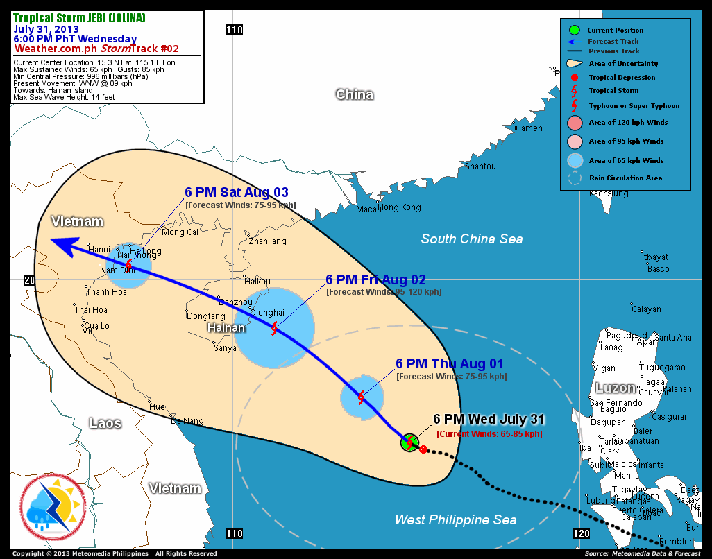
As of 6:00 pm today, the center of TS Jebi (Jolina) was located over the western boundary of the PAR in the West Philippine Sea, just west of Panatag (Scarborough) Shoal...about 560 km west-northwest of Subic Bay, Zambales or 775 km south-southeast of Hong Kong, China...currently moving west-northwest with a decreased forward speed of 9 km/hr in the general direction of Hainan Island.

Maximum Sustained Winds (1-min. avg) have increased to near 65 km/hr near the center with higher gusts. Jebi (Jolina) is an average-sized tropical cyclone with a diameter of 445 kilometers across. The 24-hour rainfall accumulation near the center of Jebi (Jolina) is estimated to be heavy (300 mm).


2-DAY FORECAST OUTLOOK*

TS Jebi (Jolina) is expected to move northwest for the next 24 hours with a turn to the west-northwest throughout the forecast period. On the forecast track, the core of Jebi (Jolina) will be moving across the South China Sea on Thursday evening...and approaching the eastern coast of Hainan Island on Friday evening.

Jebi (Jolina) will continue to intensify within the next 24 to 48 hours as it moves towards Hainan Island. Advance Intensity Forecast (AIF) shows the storm reaching its peak sustained winds of 95 km/hr on Friday.

The following is the summary of the 2-day forecast outlook and an extended 3-day forecast on this system:

THURSDAY EVENING: Continues to strengthen as it moves across the South China Sea...about 625 km south of Hong Kong, China [6PM AUGUST 01: 16.6N 113.7E @ 75kph].
FRIDAY EVENING: Becomes a strong TS as it approaches the eastern coast of Hainan Island...about 100 km southeast of Qionghai, Hainan Island [6PM AUGUST 02: 18.6N 111.2E @ 95kph].
SATURDAY EVENING: Weakens after crossing Hainan Island...over the Gulf of Tonkin...about 65 km south of Ha Long Bay, Vietnam [6PM AUGUST 03: 20.4N 107.0E @ 75kph].

*Please be reminded that the Forecast Outlook changes every 6 hours, and the Day 2 and 3 Forecast Tracks have an average error of 100 and 250 km respectively...while the wind speed forecast error, averages 35 kph per day. Therefore, a turn to the left or right of its future track and changes in its wind speed must be anticipated from time to time.


EFFECTS & HAZARDS SUMMARY

Below is the summary of the storm's parts and its hazards affecting specific areas. You can also view this image link for you to understand the parts.

INNER RAINBANDS - where Tropical Storm Conditions with Tropical Storm Force Winds (63-85 kph) will be expected. Affected Areas: Central portion of the South China Sea.
OUTER RAINBANDS - where Tropical Depression Conditions with light, moderate to strong winds (30-55 kph) will be expected. Affected Areas: Panatag (Scarborough) Shoal, West Philippine and South China Seas, and the coastal areas of Zambales. (click here to know more about Rainbands)
24HR TOTAL RAINFALL ACCUMULATION - from 5 up to 100 mm (slight to heavy rainfall) can be expected along areas affected by the outer & inner rainbands (see above)...with isolated amounts of 101 to 300 mm (heavy) along areas to the south, west and near the center of Jebi (Jolina).

Important Note: Please keep in mind that the above forecast outlook, effects and hazards summary changes every 6 to 12 hrs!


CURRENT TECHNICAL INFORMATION

Time/Date: 6:00 PM PhT Wed July 31, 2013
Class/Name: TS Jebi (Jolina)
Location of Center: 15.3º N Lat 115.1º E Lon
Distance 1: 525 km W of Iba, Zambales
Distance 2: 560 km WNW of Subic Bay
Distance 3: 655 km SE of Qionghai, Hainan Is.
Distance 4: 745 km ESE of Da Nang, Vietnam
Distance 5: 775 km SSE of Hong Kong
Distance 6: 785 km SSE of Macau
MaxWinds (1-min avg): 65 kph near the center
Peak Wind Gusts: 85 kph
Present Movement: WNW @ 9 kph
Towards: Hainan Island
24hr Rainfall Accum (near center): Heavy [300 mm]
Minimum Central Pressure: 1000 millibars (hPa)
Size (in Diameter): 445 km [Average]
Max Sea Wave Height (near center): 14 feet
Possible Storm Surge Height: 0 ft (0 m)

T2K/WP StormTracks (for Public): GIF | Google Map (Flash)


__________________________________________________________________________________________________

CURRENT TRACKING MAP:

http://www.typhoon2000.ph/advisorytrax/2013/jolina02.gif_____________________________________________________________________________


CURRENT NOAA/MTSAT-2 SATELLITE ANIMATION:

http://www.ssd.noaa.gov/PS/TROP/floaters/09W/imagery/rgb-animated.gif
__________________________________________________________________________________________________

CURRENT NOAA/MTSAT-2 INFRARED (IR) SATELLITE IMAGE
:


http://www.ssd.noaa.gov/PS/TROP/floaters/09W/imagery/rb0-lalo.jpg

__________________________________________________________________________________________________


NOTE:

>> To know the meteorological terminologies and acronyms used on this update visit the ff:

   
http://typhoon2000.ph/tcterm.htm  
   
http://www.nhc.noaa.gov/aboutgloss.shtml
    http://www.nhc.noaa.gov/acronyms.shtml
__________________________________________________________________________________________

For the complete details on TS JEBI (JOLINA)...go visit our website @:

>
http://www.typhoon2000.com
http://www.maybagyo.com

:: Kindly view our site's disclaimer at: 
   
http://www.typhoon2000.ph/disclaimer.htm
__________________________________________________________________________________________

<<<Typhoon2000.com Mobile >>>
Get the latest SMS Storm Alerts!
For more details: Text T2K TYPHOON to

2800 (Globe/TM) | Offline (Smart/TNT) | 2288 (Sun)
*Only P2.50 (Smart/Globe) / P2.00 (Sun) per msg received.

Click here on how to use this service (in PDF file)
Powered by: Synermaxx Corporation


Copyright © 2013 Typhoon2000.com     All Rights Reserved

__._,_.___
Reply via web post Reply to sender Reply to group Start a New Topic Messages in this topic (1)
Recent Activity:
.

__,_._,___

TD JEBI (JOLINA) Update #001.


for Wednesday, 31 July 2013 [3:18 PM PhT]

WEATHER.COM.PH TROPICAL CYCLONE UPDATES

TROPICAL DEPRESSION JEBI (JOLINA) UPDATE NUMBER 001
Issued: 1:00 PM PhT (05:00 GMT) Wednesday 31 July 2013
Next Update: 7:00 PM PhT (11:00 GMT) Wednesday 31 July 2013


The strong Tropical Disturbance (LPA) 91W over the West Philippine Sea, west of Luzon has strengthened into a Tropical Depression (TD) internationally named as JEBI (JOLINA). JEBI is a Korean name for a Swallow bird. Its elongated and broad rainbands are bringing rains and thunderstorms across the West Philippine and South China Seas.

This depression will slightly enhance the Southwest Monsoon (Hanging Habagat) and bring cloudy conditions with occasionally slight to moderate to sometimes heavy rains and thunderstorms across MiMaRoPa, Sulu Sea, and Western Visayas today. Flash floods and landslides are likely in hazard-prone areas especially along mountain slopes. Meanwhile, the ITCZ will continue to bring isolated to scattered thunderstorms across the Philippines including Metro Manila.


Residents and visitors along Hainan Island, Southern China and Northern Vietnam should closely monitor the development of Jebi (Jolina).

Do not use this for life or death decisions. This update is intended for additional information purposes only. Kindly refer to your national weather agency for official warnings, advisories or bulletins.


CURRENT STORM ANALYSIS

As of 12:00 noon today, the center of TD Jebi (Jolina) was located over the West Philippine Sea, near Scarborough Shoal...about 515 km west-northwest of Subic Bay, Zambales or 800 km south-southeast of Hong Kong, China...currently moving west-northwest with a forward speed of 19 km/hr in the general direction of Hainan Island.

Maximum Sustained Winds (1-min. avg) are near 55 km/hr near the center with higher gusts. Jebi (Jolina) is an average-sized tropical cyclone with a diameter of 445 kilometers across. The 24-hour rainfall accumulation near the center of Jebi (Jolina) is estimated to be heavy (200 mm).


2-DAY FORECAST OUTLOOK*

TD Jebi (Jolina) is expected to move northwest for the next 24 hours with a turn to the west-northwest throughout the forecast period. On the forecast track, the core of Jebi (Jolina) will exit the Philippine Area of Responsibility (PAR) later this afternoon or evening...moving across the South China Sea on Thursday...and approaching the eastern coast of Hainan Island on Friday.

Jebi (Jolina) will gradually intensify through the next 48 hours as it moves towards Hainan Island...and could become a Tropical Storm (TS) later this afternoon. Advance Intensity Forecast (AIF) shows the system reaching its peak sustained winds of 95 km/hr on Friday.

The following is the summary of the 2-day forecast outlook and an extended 3-day forecast on this system:

THURSDAY NOON: Upgraded to a TS as it exits PAR...about 690 km south of Hong Kong, China [12PM AUGUST 01: 16.0N 114.5E @ 75kph].
FRIDAY NOON: Becomes a strong TS as it approaches the eastern coast of Hainan Island...about 220 km southeast of Qionghai, Hainan Island [12PM AUGUST 02: 17.9N 112.1E @ 95kph].
SATURDAY NOON: Weakens after crossing Hainan Island...over the Gulf of Tonkin...about 155 km southeast of Ha Long Bay, Vietnam [12PM AUGUST 03: 19.9N 107.9E @ 75kph].

*Please be reminded that the Forecast Outlook changes every 6 hours, and the Day 2 and 3 Forecast Tracks have an average error of 100 and 250 km respectively...while the wind speed forecast error, averages 35 kph per day. Therefore, a turn to the left or right of its future track and changes in its wind speed must be anticipated from time to time.


EFFECTS & HAZARDS SUMMARY

Below is the summary of the storm's parts and its hazards affecting specific areas. You can also view this image link for you to understand the parts.

DEVELOPING RAINBANDS - where Tropical Depression Conditions with light, moderate to strong winds (30-55 kph) will be expected. Affected Areas: West Philippine and South China Seas, and the coastal areas of Zambales. (click here to know more about Rainbands)
24HR TOTAL RAINFALL ACCUMULATION - from 5 up to 100 mm (slight to heavy rainfall) can be expected along areas affected by the outer & inner rainbands (see above)...with isolated amounts of 101 to 200 mm (heavy) along areas to the south and near the center of Jebi (Jolina).

Important Note: Please keep in mind that the above forecast outlook, effects and hazards summary changes every 6 to 12 hrs!


CURRENT TECHNICAL INFORMATION

Time/Date: 12:00 NN PhT Wed July 31, 2013
Class/Name: TD Jebi (Jolina)
Location of Center: 15.1º N Lat 115.5º E Lon
Distance 1: 485 km W of Iba, Zambales
Distance 2: 515 km WNW of Subic Bay
Distance 3: 700 km SE of Qionghai, Hainan Is.
Distance 4: 790 km ESE of Da Nang, Vietnam
Distance 5: 800 km SSE of Hong Kong
Distance 6: 815 km SSE of Macau
MaxWinds (1-min avg): 55 kph near the center
Peak Wind Gusts: 75 kph
Present Movement: WNW @ 19 kph
Towards: Hainan Island
24hr Rainfall Accum (near center): Heavy [200 mm]
Minimum Central Pressure: 1000 millibars (hPa)
Size (in Diameter): 445 km [Average]
Max Sea Wave Height (near center): 14 feet
Possible Storm Surge Height: 0 ft (0 m)

T2K/WP StormTracks (for Public): GIF | Google Map (Flash)


__________________________________________________________________________________________________

CURRENT TRACKING MAP:

http://www.typhoon2000.ph/advisorytrax/2013/jolina01.gif_____________________________________________________________________________


CURRENT NOAA/MTSAT-2 SATELLITE ANIMATION:

http://weather.com.ph/images/20130731053012.gif
__________________________________________________________________________________________________

CURRENT NOAA/MTSAT-2 INFRARED (IR) SATELLITE IMAGE
:


http://www.ssd.noaa.gov/PS/TROP/floaters/09W/imagery/rb0-lalo.jpg

__________________________________________________________________________________________________


NOTE:

>> To know the meteorological terminologies and acronyms used on this update visit the ff:

   
http://typhoon2000.ph/tcterm.htm  
   
http://www.nhc.noaa.gov/aboutgloss.shtml
    http://www.nhc.noaa.gov/acronyms.shtml
__________________________________________________________________________________________

For the complete details on TD JEBI (JOLINA)...go visit our website @:

>
http://www.typhoon2000.com
http://www.maybagyo.com

:: Kindly view our site's disclaimer at: 
   
http://www.typhoon2000.ph/disclaimer.htm
__________________________________________________________________________________________

<<<Typhoon2000.com Mobile >>>
Get the latest SMS Storm Alerts!
For more details: Text T2K TYPHOON to

2800 (Globe/TM) | Offline (Smart/TNT) | 2288 (Sun)
*Only P2.50 (Smart/Globe) / P2.00 (Sun) per msg received.

Click here on how to use this service (in PDF file)
Powered by: Synermaxx Corporation


Copyright © 2013 Typhoon2000.com     All Rights Reserved

__._,_.___
Reply via web post Reply to sender Reply to group Start a New Topic Messages in this topic (1)
Recent Activity:
.

__,_._,___

Friday, July 19, 2013

TD CIMARON (ISANG) Final Update


for Wednesday, 17 July 2013 [3:16 PM PhT]

WEATHER.COM.PH TROPICAL CYCLONE UPDATES

TROPICAL DEPRESSION CIMARON (ISANG) UPDATE NUMBER 010 [FINAL]
Issued: 7:00 AM PhT (23:00 GMT) Friday 19 July 2013

CIMARON (ISANG) downgraded to a Tropical Depression (TD) as it lingers over the southern part of Fujian Province in Southern China. Dissipating rainbands will continue to dump moderate to heavy rains over the area.

*This is the last and final update on Cimaron (Isang).

Do not use this for life or death decisions. This update is intended for additional information purposes only. Kindly refer to your national weather agency for official warnings, advisories or bulletins.


CURRENT STORM ANALYSIS

As of 6:00 am today, the center of TD Cimaron (Isang) was located over Southern Fujian...about 95 km west-southwest of Xiamen City, China or 100 km north-northeast of Shantou City, China...currently moving north-northeast slowly.

Maximum Sustained Winds (1-min. avg) have decreased to near 45 km/hr near the center with higher gusts. Cimaron (Isang) is a small-sized tropical cyclone with a diameter of 300 kilometers across. The 24-hour rainfall accumulation near the center of Cimaron (Isang) is estimated to be extreme (400 mm).


EFFECTS & HAZARDS SUMMARY

Below is the summary of the storm's parts and its hazards affecting specific areas. You can also view this image link for you to understand the parts.

DECAYING RAINBANDS - where Tropical Depression Conditions with light, moderate to strong winds (30-55 kph) will be expected. Affected Areas: The rest of the coastal areas of Eastern Guangdong and Fujian, and Taiwan Strait. (click here to know more about Rainbands)
24HR TOTAL RAINFALL ACCUMULATION - from 5 up to 100 mm (slight to heavy rainfall) can be expected along areas affected by the outer & inner rainbands (see above)...with isolated amounts of 101 to 400 mm (heavy) along areas to the east and near the center of Cimaron (Isang).

Important Note: Please keep in mind that the above forecast outlook, effects and hazards summary changes every 6 to 12 hrs!


CURRENT TECHNICAL INFORMATION

Time/Date: 6:00 AM PhT Fri July 19, 2013
Class/Name: TD Cimaron (Isang)
Location of Center: 24.3º N Lat 117.2º E Lon
Distance 1: 95 km WSW of Xiamen, China
Distance 2: 100 km NNE of Shantou, China
Distance 3: 290 km SW of Fuzhou, Taiwan
Distance 4: 370 km NW of Kaohsiung, Taiwan
Distance 5: 380 km ENE of Hong Kong
MaxWinds (1-min avg): 45 kph near the center
Peak Wind Gusts: 65 kph
Present Movement: NNE Slowly
Towards: Southern Fujian
24hr Rainfall Accum (near center): Extreme [400 mm]
Minimum Central Pressure: 1002 millibars (hPa)
Size (in Diameter): 300 km [Small]
Max Sea Wave Height (near center): 16 feet
Possible Storm Surge Height: 0 ft (0 m)

T2K/WP StormTracks (for Public): GIF | Google Map (Flash)


__________________________________________________________________________________________________

CURRENT TRACKING MAP:

http://www.typhoon2000.ph/advisorytrax/2013/isang10.gif_____________________________________________________________________________


CURRENT NOAA/MTSAT-2 SATELLITE ANIMATION:

http://weather.com.ph/images/20130719000819.gif
__________________________________________________________________________________________________

CURRENT NOAA/MTSAT-2 INFRARED (IR) SATELLITE IMAGE
:


http://www.ssd.noaa.gov/PS/TROP/floaters/08W/imagery/rbtop0-lalo.jpg

__________________________________________________________________________________________________


NOTE:

>> To know the meteorological terminologies and acronyms used on this update visit the ff:

   
http://typhoon2000.ph/tcterm.htm  
   
http://www.nhc.noaa.gov/aboutgloss.shtml
    http://www.nhc.noaa.gov/acronyms.shtml
__________________________________________________________________________________________

For the complete final details on TD CIMARON (ISANG)...go visit our website @:

>
http://www.typhoon2000.com
http://www.maybagyo.com

:: Kindly view our site's disclaimer at: 
   
http://www.typhoon2000.ph/disclaimer.htm
__________________________________________________________________________________________

<<<Typhoon2000.com Mobile >>>
Get the latest SMS Storm Alerts!
For more details: Text T2K TYPHOON to

2800 (Globe/TM) | Offline (Smart/TNT) | 2288 (Sun)
*Only P2.50 (Smart/Globe) / P2.00 (Sun) per msg received.

Click here on how to use this service (in PDF file)
Powered by: Synermaxx Corporation


Copyright © 2013 Typhoon2000.com     All Rights Reserved

__._,_.___
Reply via web post Reply to sender Reply to group Start a New Topic Messages in this topic (1)
Recent Activity:
.

__,_._,___

Thursday, July 18, 2013

TS CIMARON (ISANG) Update #009


for Thursday, 18 July 2013 [8:17 PM PhT]

WEATHER.COM.PH TROPICAL CYCLONE UPDATES

TROPICAL STORM CIMARON (ISANG) UPDATE NUMBER 009
Issued: 7:00 PM PhT (11:00 GMT) Thursday 18 July 2013
Next Update: 7:00 AM PhT (23:00 GMT) Friday 19 July 2013


Tropical Storm CIMARON (ISANG) has slowed down as it prepares to make landfall over eastern part of Guangdong Province, very near the city of Shantou.

Residents and visitors along Southern and Southeastern China should closely monitor the development of Cimaron (Isang).

Do not use this for life or death decisions. This update is intended for additional information purposes only. Kindly refer to your national weather agency for official warnings, advisories or bulletins.


CURRENT STORM ANALYSIS

As of 6:00 pm today, the center of TS Cimaron (Isang) was located along the coast of Eastern Guangdong...about 45 km southeast of Shantou City, China or 305 km east-northeast of Hong Kong...currently moving north-northwest with a decreased forward speed of 11 km/hr in the general direction of Eastern Guangdong.

Maximum Sustained Winds (1-min. avg) remain near 75 km/hr near the center with higher gusts. Tropical Storm Force Winds (62-95 km/hr) extend outward up to 75 kilometers from the center. Cimaron (Isang) is a small-sized tropical cyclone with a diameter of 335 kilometers across. The 24-hour rainfall accumulation near the center of Cimaron (Isang) is estimated to be extreme (400 mm).


1-DAY FORECAST OUTLOOK*

TS Cimaron (Isang) is expected to continue moving north-northwest throughout the forecast period. On the forecast track, the core of Cimaron (Isang) will make landfall over Eastern Guangdong very near Shantou City tonight and will continue to move overland across the southern part of Jiangxi Province, Southern China on Friday.

Cimaron (Isang) will gradually weaken overnight as it makes landfall and move across land. Advance Intensity Forecast (AIF) shows the system dissipating into an area of low pressure by Friday evening.

The following is the summary of the 1-day forecast outlook on this system:

FRIDAY EVENING: Just an area of low pressure moving across Southern Jiangxi...about 220 km west-northwest of Xiamen, China [6PM JULY 19: 25.5N 116.2E @ 35kph].

*Please be reminded that the Forecast Outlook changes every 6 hours, and the Day 3 Forecast Track have an average error of 250 km...while the wind speed forecast error, averages 35 kph per day. Therefore, a turn to the left or right of its future track and changes in its wind speed must be anticipated from time to time.


EFFECTS & HAZARDS SUMMARY

Below is the summary of the storm's parts and its hazards affecting specific areas. You can also view this image link for you to understand the parts.

INNER RAINBANDS - where Tropical Storm Conditions with Tropical Storm Force Winds (63-85 kph) will be expected. Affected Areas: Coastal areas of Eastern Guangdong.
OUTER RAINBANDS - where Tropical Depression Conditions with light, moderate to strong winds (30-62 kph) will be expected. Affected Areas: The rest of the coastal areas of Guangdong and Southern Fujian, Taiwan Strait, and the Northern part of the South China Sea. (click here to know more about Rainbands)
24HR TOTAL RAINFALL ACCUMULATION - from 5 up to 100 mm (slight to heavy rainfall) can be expected along areas affected by the outer & inner rainbands (see above)...with isolated amounts of 101 to 400 mm (heavy) along areas to the east and near the center of Cimaron (Isang).

Important Note: Please keep in mind that the above forecast outlook, effects and hazards summary changes every 6 to 12 hrs!


CURRENT TECHNICAL INFORMATION

Time/Date: 6:00 PM PhT Thu July 18, 2013
Class/Name: TS Cimaron (Isang)
Location of Center: 23.2º N Lat 117.0º E Lon
Distance 1: 45 km SE of Shantou, China
Distance 2: 190 km SW of Xiamen, China
Distance 3: 345 km WNW of Kaohsiung, Taiwan
Distance 4: 305 km ENE of Hong Kong
MaxWinds (1-min avg): 75 kph near the center
Peak Wind Gusts: 95 kph
Present Movement: NNW @ 11 kph
Towards: Eastern Guangdong
24hr Rainfall Accum (near center): Extreme [400 mm]
Minimum Central Pressure: 993 millibars (hPa)
Size (in Diameter): 335 km [Small]
Max Sea Wave Height (near center): 16 feet
Possible Storm Surge Height: 0 ft (0 m)

T2K/WP StormTracks (for Public): GIF | Google Map (Flash)


__________________________________________________________________________________________________

CURRENT TRACKING MAP:

http://www.typhoon2000.ph/advisorytrax/2013/isang09.gif_____________________________________________________________________________


CURRENT NOAA/MTSAT-2 SATELLITE ANIMATION:

http://weather.com.ph/images/20130718114653.gif
__________________________________________________________________________________________________

CURRENT NOAA/MTSAT-2 INFRARED (IR) SATELLITE IMAGE
:


http://www.ssd.noaa.gov/PS/TROP/floaters/08W/imagery/rbtop0-lalo.jpg

__________________________________________________________________________________________________


NOTE:

>> To know the meteorological terminologies and acronyms used on this update visit the ff:

   
http://typhoon2000.ph/tcterm.htm  
   
http://www.nhc.noaa.gov/aboutgloss.shtml
    http://www.nhc.noaa.gov/acronyms.shtml
__________________________________________________________________________________________

For the complete details on TS CIMARON (ISANG)...go visit our website @:

>
http://www.typhoon2000.com
http://www.maybagyo.com

:: Kindly view our site's disclaimer at: 
   
http://www.typhoon2000.ph/disclaimer.htm
__________________________________________________________________________________________

<<<Typhoon2000.com Mobile >>>
Get the latest SMS Storm Alerts!
For more details: Text T2K TYPHOON to

2800 (Globe/TM) | Offline (Smart/TNT) | 2288 (Sun)
*Only P2.50 (Smart/Globe) / P2.00 (Sun) per msg received.

Click here on how to use this service (in PDF file)
Powered by: Synermaxx Corporation


Copyright © 2013 Typhoon2000.com     All Rights Reserved

__._,_.___
Reply via web post Reply to sender Reply to group Start a New Topic Messages in this topic (1)
Recent Activity:
.

__,_._,___