Sunday, February 02, 2014

TD KAJIKI (BASYANG) Final Update


for Sunday, 02 February 2014 [12:52 PM PhT]

WEATHER.COM.PH TROPICAL CYCLONE UPDATES

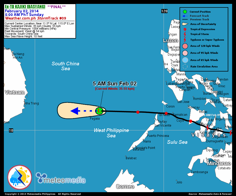
EX-TROPICAL DEPRESSION KAJIKI (BASYANG) UPDATE NUMBER 009 [FINAL]
Issued at: 6:00 AM PhT (22:00 GMT) Sunday 02 February 2014

KAJIKI (BASYANG) has dissipated into an area of low pressure...and quickly moved westward across the West Philippine and South China Seas.


*This is the last and final update on Kajiki (Basyang).

Information based on data collected by WeatherPhilippines Foundation, Inc. shall not be taken as official data. Weather information broadcasted and distributed by PAGASA remains as official data. WeatherPhilippines shall not be responsible for the private use and reliance of its weather information.


CURRENT CYCLONE INFORMATION

As of 5:00 AM PhT today...2100 GMT...

Location: Over the West Philippine-South China Seas (near 11.5N 115.0E)
About: 90 km northeast of Pagasa Island
Maximum Sustained Winds (1-min avg): 35 kph near the center...Gustiness: 55 kph
Past Movement: West at 54 kph
Towards: South China Sea


CYCLONE HAZARDS AFFECTING LAND

Below are the regions or places with possible or ongoing effects caused by the current tropical cyclone.

NONE .

Important Note: Please keep in mind that the above forecast outlook and hazards summary changes every 6 to 12 hrs!


ADDITIONAL DISTANCES & TECHNICAL INFO

Time/Date: 5:00 AM PhT Sun Feb 02, 2014
Class/Name: Ex-TD Kajiki (Basyang)
Minimum Central Pressure: 1004 millibars (hPa)

Location of Center: Near 11.5º N Lat 115.0º E Lon
Distance 1: 90 km NE of Pagasa Island, Spratlys
Distance 2: 515 km W of El Nido, Palawan
Distance 3: 635 km ESE of Nha Trang, Vietnam
Distance 4: 450 km NW of Puerto Princesa, Palawan
Distance 5: 735 km SW of Metro Manila
T2K/WP StormTracks (for Public): GIF

__________________________________________________________________________________________________

CURRENT TRACKING MAP:

http://www.typhoon2000.ph/advisorytrax/2014/basyang09.gif _____________________________________________________________________________


CURRENT NOAA/MTSAT-2 SATELLITE ANIMATION:

http://weather.com.ph/images/20140202002915.gif

__________________________________________________________________________________________________

CURRENT NOAA/MTSAT-2 INFRARED (IR) SATELLITE IMAGE
:


http://www.ssd.noaa.gov/PS/TROP/floaters/02W/imagery/rb0-lalo.jpg

__________________________________________________________________________________________________


NOTE:

>> To know the meteorological terminologies and acronyms used on this update visit the ff:

   
http://typhoon2000.ph/tcterm.htm  
   
http://www.nhc.noaa.gov/aboutgloss.shtml
    http://www.nhc.noaa.gov/acronyms.shtml
__________________________________________________________________________________________

For the complete details on TD KAJIKI (BASYANG)...go visit our website @:

>
http://www.typhoon2000.com
http://www.maybagyo.com

:: Kindly view our site's disclaimer at: 
   
http://www.typhoon2000.ph/disclaimer.htm
__________________________________________________________________________________________

<<<Typhoon2000.com Mobile >>>
Get the latest SMS Storm Alerts!
For more details: Text T2K TYPHOON to

2800 (Globe/TM) | Offline (Smart/TNT) | 2288 (Sun)
*Only P2.50 (Smart/Globe) / P2.00 (Sun) per msg received.

Click here on how to use this service (in PDF file)
Powered by: Synermaxx Corporation


Copyright © 2014 Typhoon2000.com     All Rights Reserved

__._,_.___
Reply via web post Reply to sender Reply to group Start a New Topic Messages in this topic (1)
Recent Activity:
.

__,_._,___

Saturday, February 01, 2014

TD KAJIKI (BASYANG) Update #008


for Saturday, 01 February 2014 [7:44 PM PhT]

WEATHER.COM.PH TROPICAL CYCLONE UPDATES

TROPICAL DEPRESSION KAJIKI (BASYANG) UPDATE NUMBER 008
Issued at: 7:30 PM PhT (11:30 GMT) Saturday 01 February 2014
Next Update: 6:00 AM PhT (22:00 GMT) Sunday 02 February 2014


The rain-free center of Tropical Depression KAJIKI (BASYANG) has started to cross the Calamian Island Group (Northern Palawan). Its thick convective rainbands remain displaced but is now over the West Philippine Sea...thus, improving weather expected across Palawan later tonight.

Residents and visitors along MiMaRoPa should closely monitor the development of TD Kajiki (Basyang).

Information based on data collected by WeatherPhilippines Foundation, Inc. shall not be taken as official data. Weather information broadcasted and distributed by PAGASA remains as official data. WeatherPhilippines shall not be responsible for the private use and reliance of its weather information.


CURRENT CYCLONE INFORMATION

As of 5:00 PM PhT today...0900 GMT...

Location: Near Beni Island or off Sulu Sea (near 11.3N 120.2E)
About: 55 km east of El Nido, Palawan...80 km south of Coron, Palawan
Maximum Sustained Winds (1-min avg): 55 kph near the center...Gustiness: 75 kph
24 hr. Rain Accumulation (west of center): 150 mm [Heavy to Extreme]
Size (in diameter): 500 km (Small)
Past Movement: West-northwest at 35 kph
Forecast Movement: Northwest at 15 kph
Towards: Calamian Group-West Philippine Sea Area


2-DAY FORECAST OUTLOOK*

Kajiki (Basyang) is expected to move west-northwest to northwest within the next 24 to 48 hrs On the forecast track, the core of TD Kajiki (Basyang) will be moving across the West Philippine Sea later tonight through Sunday afternoon and will exit the Philippine Area of Responsibility (PAR) early Monday morning. On Monday afternoon, Kajiki (Basyang) will be moving above the cooler waters of the South China Sea, east of Vietnam.

Kajiki (Basyang) is expected to weaken further within the next 24 hours as it moves over an area of unfavorable environment. Advance Intensity Forecast (AIF) shows its 1-minute maximum sustained winds decreasing to 45 kph on Sunday afternoon.

The following is the summary of the 2-day forecast outlook on this system:

SUNDAY AFTERNOON: Weakens further as it moves over the West Philippine Sea...about 300 km WNW of Coron, Palawan [2PM FEB 02: 12.5N 117.5E @ 45kph].
MONDAY AFTERNOON: Already outside of the PAR...dissipates into an area of low pressure while over the South China Sea...about 565 km SE of Da Nang, Vietnam [2PM FEB 03: 14.0N 113.0E @ 35kph].

*Please be reminded that the Forecast Outlook changes every 6 hours, and the Day 2 and 3 Forecast Track has an average error of 100 and 250 km respectively...while the wind speed forecast error, averages 35 kph per day. Therefore, a turn to the left or right of its future track and changes in its wind speed must be anticipated from time to time.


CYCLONE HAZARDS AFFECTING LAND

Below are the regions or places with possible or ongoing effects caused by the current tropical cyclone.

PALAWAN / CALAMIAN GROUP:  Moderate to heavy rains of 30-50 mm will be experienced along these areas until tonight. Residents living along hazard-prone areas are advised to seek shelter and take precautionary measures against flashfloods and landslides.

Important Note: Please keep in mind that the above forecast outlook and hazards summary changes every 6 to 12 hrs!


ADDITIONAL DISTANCES & TECHNICAL INFO

Time/Date: 5:00 PM PhT Sat Feb 01, 2014
Class/Name: TD Kajiki (Basyang)
Minimum Central Pressure: 1000 millibars (hPa)

Location of Center: Near 11.3º N Lat 120.2º E Lon
Distance 1: 55 km E of El Nido, Palawan
Distance 2: 55 km W of Pamalican Island
Distance 3: 80 km S of Coron, Palawan
Distance 4: 100 km NW of Cuyo Island
Distance 5: 195 km WSW of Boracay Island
T2K/WP StormTracks (for Public): GIF

__________________________________________________________________________________________________

CURRENT TRACKING MAP:

http://www.typhoon2000.ph/advisorytrax/2014/basyang08.gif _____________________________________________________________________________


CURRENT NOAA/MTSAT-2 SATELLITE ANIMATION:

http://weather.com.ph/images/20140201122039.gif

__________________________________________________________________________________________________

CURRENT NOAA/MTSAT-2 INFRARED (IR) SATELLITE IMAGE
:


http://www.ssd.noaa.gov/PS/TROP/floaters/02W/imagery/rb0-lalo.jpg

__________________________________________________________________________________________________


NOTE:

>> To know the meteorological terminologies and acronyms used on this update visit the ff:

   
http://typhoon2000.ph/tcterm.htm  
   
http://www.nhc.noaa.gov/aboutgloss.shtml
    http://www.nhc.noaa.gov/acronyms.shtml
__________________________________________________________________________________________

For the complete details on TD KAJIKI (BASYANG)...go visit our website @:

>
http://www.typhoon2000.com
http://www.maybagyo.com

:: Kindly view our site's disclaimer at: 
   
http://www.typhoon2000.ph/disclaimer.htm
__________________________________________________________________________________________

<<<Typhoon2000.com Mobile >>>
Get the latest SMS Storm Alerts!
For more details: Text T2K TYPHOON to

2800 (Globe/TM) | Offline (Smart/TNT) | 2288 (Sun)
*Only P2.50 (Smart/Globe) / P2.00 (Sun) per msg received.

Click here on how to use this service (in PDF file)
Powered by: Synermaxx Corporation


Copyright © 2014 Typhoon2000.com     All Rights Reserved

__._,_.___
Reply via web post Reply to sender Reply to group Start a New Topic Messages in this topic (1)
Recent Activity:
.

__,_._,___

TD KAJIKI (BASYANG) Update #007


for Saturday, 01 February 2014 [2:52 PM PhT]

WEATHER.COM.PH TROPICAL CYCLONE UPDATES

TROPICAL DEPRESSION KAJIKI (BASYANG) UPDATE NUMBER 007
Issued at: 12:30 PM PhT (04:30 GMT) Saturday 01 February 2014
Next Update: 6:00 PM PhT (10:00 GMT) Saturday 01 February 2014


KAJIKI (BASYANG) has weakened into a Tropical Depression as it traverses Western Visayas...associated cloudiness are still bringing moderate to heavy downpours across Western Visayas and Palawan which could trigger flashfloods and landslides.

Residents and visitors along MiMaRoPa should closely monitor the development of TD Kajiki (Basyang).

Information based on data collected by WeatherPhilippines Foundation, Inc. shall not be taken as official data. Weather information broadcasted and distributed by PAGASA remains as official data. WeatherPhilippines shall not be responsible for the private use and reliance of its weather information.


CURRENT CYCLONE INFORMATION

As of 11:00 AM PhT today...0300 GMT...

Location: Along the southern border of Iloilo and Antique (near 10.7N 122.1E)
About: 45 km west of Iloilo City...or 120 km east-southeast of Cuyo Island
Maximum Sustained Winds (1-min avg): 55 kph near the center...Gustiness: 75 kph
24 hr. Rain Accumulation (near its center): 300 mm [Extreme]
Size (in diameter): 500 km (Small)
Past Movement: West-northwest at 26 kph
Forecast Movement: West-northwest at 19 kph
Towards: Northern Sulu-West Philippine Seas


3-DAY FORECAST OUTLOOK*

Kajiki (Basyang) is expected to move west-northwest to northwest within the next 24 to 48 hrs, with a turn to the west through 72 hrs. On the forecast track, the core of TD Kajiki (Basyang) will be crossing Northern Sulu Sea this afternoon through evening...and will traverse the West Philippine Sea late tonight through Monday morning before it exits the Philippine Area of Responsibility. Kajiki will then be over the South China Sea by Tuesday noon.

Kajiki (Basyang) is expected to weaken further within the next 24 hours as it moves over an area of unfavorable environment. Advance Intensity Forecast (AIF) shows its 1-minute maximum sustained winds decreasing to 45 kph on Sunday morning.

The following is the summary of the 3-day forecast outlook on this system:

SUNDAY MORNING: Weakens further as it moves over the West Philippine Sea...about 175 km WNW of El Nido, Palawan [8AM FEB 02: 12.0N 118.2E @ 45kph].
MONDAY MORNING: Maintains its strength while moving farther into the West Philippine Sea...about 285 km NE of Pagasa Island, Spratlys [8AM FEB 03: 13.3N 115.5E @ 45kph].
TUESDAY MORNING: Dissipates into an area of low pressure as it moves over the South China Sea...about 290 km NW of Pagasa Island, Spratlys [8AM FEB 04: 13.4N 113.0E @ 35kph].

*Please be reminded that the Forecast Outlook changes every 6 hours, and the Day 2 and 3 Forecast Track has an average error of 100 and 250 km respectively...while the wind speed forecast error, averages 35 kph per day. Therefore, a turn to the left or right of its future track and changes in its wind speed must be anticipated from time to time.


CYCLONE HAZARDS AFFECTING LAND

Below are the regions or places with possible or ongoing effects caused by the current tropical cyclone.

NORTHERN PALAWAN:  Heavy rains of 50 to 100 mm will be experienced until Sunday morning. Residents living along the hazard-prone areas are advised to seek shelter and take precautionary measures against flashfloods and landslides.

WESTERN VISAYAS / ROMBLON / CALAMIAN AND CUYO ISLAND GROUP / PORTIONS OF CENTRAL PALAWAN:  Moderate to heavy rains of 30-50 mm will be experienced along these areas today...extending through Sunday morning across portions of Central Palawan and the Calamian Group of Islands.. Residents living along hazard-prone areas are advised to seek shelter and take precautionary measures against flashfloods and landslides.

Important Note: Please keep in mind that the above forecast outlook and hazards summary changes every 6 to 12 hrs!


ADDITIONAL DISTANCES & TECHNICAL INFO

Time/Date: 11:00 AM PhT Sat Feb 01, 2014
Class/Name: TD Kajiki (Basyang)
Minimum Central Pressure: 1000 millibars (hPa)

Location of Center: Near 10.7º N Lat 122.1º E Lon
Distance 1: 45 km W of Iloilo City
Distance 2: 120 km ESE of Cuyo Island
Distance 3: 125 km SW of Roxas City
Distance 4: 270 km ESE of El Nido Island
Distance 5: 390 km ENE of Puerto Princesa City
CPA [ETA] to Northern Palawan: Tonight [between 8-10 PM PhT]

Issued by: Leonilo C. Millanes for Weather.com.ph

__________________________________________________________________________________________________

CURRENT TRACKING MAP:

http://www.typhoon2000.ph/advisorytrax/2014/basyang07.gif _____________________________________________________________________________


CURRENT NOAA/MTSAT-2 SATELLITE ANIMATION:

http://weather.com.ph/images/20140201050236.gif

__________________________________________________________________________________________________

CURRENT NOAA/MTSAT-2 INFRARED (IR) SATELLITE IMAGE
:


http://www.ssd.noaa.gov/PS/TROP/floaters/02W/imagery/rb0-lalo.jpg

__________________________________________________________________________________________________


NOTE:

>> To know the meteorological terminologies and acronyms used on this update visit the ff:

   
http://typhoon2000.ph/tcterm.htm  
   
http://www.nhc.noaa.gov/aboutgloss.shtml
    http://www.nhc.noaa.gov/acronyms.shtml
__________________________________________________________________________________________

For the complete details on TD KAJIKI (BASYANG)...go visit our website @:

>
http://www.typhoon2000.com
http://www.maybagyo.com

:: Kindly view our site's disclaimer at: 
   
http://www.typhoon2000.ph/disclaimer.htm
__________________________________________________________________________________________

<<<Typhoon2000.com Mobile >>>
Get the latest SMS Storm Alerts!
For more details: Text T2K TYPHOON to

2800 (Globe/TM) | Offline (Smart/TNT) | 2288 (Sun)
*Only P2.50 (Smart/Globe) / P2.00 (Sun) per msg received.

Click here on how to use this service (in PDF file)
Powered by: Synermaxx Corporation


Copyright © 2014 Typhoon2000.com     All Rights Reserved

__._,_.___
Reply via web post Reply to sender Reply to group Start a New Topic Messages in this topic (1)
Recent Activity:
.

__,_._,___

TS KAJIKI (BASYANG) Update #006


for Saturday, 01 February 2014 [10:57 AM PhT]

WEATHER.COM.PH TROPICAL CYCLONE UPDATES

TROPICAL STORM KAJIKI (BASYANG) UPDATE NUMBER 006
Issued at: 7:30 AM PhT (23:30 GMT) Saturday 01 February 2014
Next Update: 12:00 PM PhT (04:00 GMT) Saturday 01 February 2014


Tropical Storm KAJIKI (BASYANG) with its thick convective rainbands moving ahead is currently traversing the Western Visayas - bringing moderate to heavy to sometimes extreme downpours which could trigger flashfloods and landslides across the affected areas.

Kajiki (Basyang) will continue to enhance the cool surge of the Northeast Monsoon (Hanging Amihan) - bringing mostly cloudy conditions w/ passing drizzles, slight to sometimes moderate rains and gusty winds (not exceeding 50 kph across the eastern sections of Luzon including Bicol Region and other parts of it this weekend.


Residents and visitors along the Visayas and MiMaRoPa should closely monitor the development of TS Kajiki (Basyang).

Information based on data collected by WeatherPhilippines Foundation, Inc. shall not be taken as official data. Weather information broadcasted and distributed by PAGASA remains as official data. WeatherPhilippines shall not be responsible for the private use and reliance of its weather information.


CURRENT CYCLONE INFORMATION

As of 5:00 AM PhT today...2100 GMT...

Location: Over Tanon Strait (near 10.2N 123.4E)
About: 70 km southeast of Bacolod City...or 55 km west-southwest of Cebu City
Maximum Sustained Winds (1-min avg): 65 kph near the center...Gustiness: 85 kph
24 hr. Rain Accumulation (near its center): 300 mm [Extreme]
Size (in diameter): 500 km (Small)
Past Movement: West to West-northwest at 32 kph
Forecast Movement: West-northwest at 20 kph
Towards: Sulu-West Philippine Seas


2-DAY FORECAST OUTLOOK*

Kajiki (Basyang) is expected to move west-northwest throughout the forecast period. On the forecast track, the core of TS Kajiki (Basyang) will be traversing Negros early this morning...and cross Sulu Sea in the afternoon through evening via the southern tip of Iloilo towards Northern Palawan. Kajiki will then be over the West Philippine Sea on Sunday early morning.

Kajiki (Basyang) is expected to weaken within the next 12 hours...becoming a Tropical Depression through the next 24 hours due to land interaction and unfavorable environment. Advance Intensity Forecast (AIF) shows its 1-minute maximum sustained winds decreasing to 45 kph on Sunday morning.

The following is the summary of the 3-day forecast outlook on this system:

SUNDAY EARLY MORNING: Weakens to a TD as it moves over the West Philippine Sea...about 60 km WNW of El Nido, Palawan [2AM FEB 02: 11.6N 119.2E @ 45kph].
MONDAY EARLY MORNING: Maintains its status as TD while moving farther into the West Philippine Sea...about 260 km NNE of Pagasa Island, Spratlys [2AM FEB 03: 13.0N 115.5E @ 45kph].
TUESDAY EARLY MORNING: Dissipates into an area of low pressure as it moves out into the South China Sea...about 290 km NW of Pagasa Island, Spratlys [8PM FEB 02: 13.5N 113.2E @ 35kph].

*Please be reminded that the Forecast Outlook changes every 6 hours, and the Day 2 and 3 Forecast Track has an average error of 100 and 250 km respectively...while the wind speed forecast error, averages 35 kph per day. Therefore, a turn to the left or right of its future track and changes in its wind speed must be anticipated from time to time.


CYCLONE HAZARDS AFFECTING LAND

Below are the regions or places with possible or ongoing effects caused by the current tropical cyclone.

NORTHERN PALAWAN:  Heavy rains of 50 to 100 mm will be experienced until Sunday morning. Residents living along the hazard-prone areas are advised to seek shelter and take precautionary measures against flashfloods and landslides.

WESTERN VISAYAS / ROMBLON / CALAMIAN AND CUYO ISLAND GROUP / PORTIONS OF CENTRAL PALAWAN:  Moderate to heavy rains of 30-50 mm will be experienced along these areas today...extending through Sunday morning across portions of Central Palawan and the Calamian Group of Islands.. Residents living along hazard-prone areas are advised to seek shelter and take precautionary measures against flashfloods and landslides.

Important Note: Please keep in mind that the above forecast outlook and hazards summary changes every 6 to 12 hrs!


ADDITIONAL DISTANCES & TECHNICAL INFO

Time/Date: 5:00 AM PhT Sat Feb 01, 2014
Class/Name: TS Kajiki (Basyang)
Minimum Central Pressure: 996 millibars (hPa)

Location of Center: Near 10.2º N Lat 123.4º E Lon
Distance 1: 70 km SE of Bacolod City
Distance 2: 55 km WSW of Cebu City
Distance 3: 105 km SE of Iloilo City
Distance 4: 70 km NW of Tagbilaran City
Distance 5: 160 km SSE of Roxas City
CPA [ETA] to Northern Palawan: Late tonight [between 11 PM-1 AM PhT]
T2K/WP StormTracks (for Public): GIF

__________________________________________________________________________________________________

CURRENT TRACKING MAP:

http://www.typhoon2000.ph/advisorytrax/2014/basyang06.gif _____________________________________________________________________________


CURRENT NOAA/MTSAT-2 SATELLITE ANIMATION:

http://weather.com.ph/images/20140201000008.gif

__________________________________________________________________________________________________

CURRENT NOAA/MTSAT-2 INFRARED (IR) SATELLITE IMAGE
:


http://www.ssd.noaa.gov/PS/TROP/floaters/02W/imagery/rb0-lalo.jpg

__________________________________________________________________________________________________


NOTE:

>> To know the meteorological terminologies and acronyms used on this update visit the ff:

   
http://typhoon2000.ph/tcterm.htm  
   
http://www.nhc.noaa.gov/aboutgloss.shtml
    http://www.nhc.noaa.gov/acronyms.shtml
__________________________________________________________________________________________

For the complete details on TS KAJIKI (BASYANG)...go visit our website @:

>
http://www.typhoon2000.com
http://www.maybagyo.com

:: Kindly view our site's disclaimer at: 
   
http://www.typhoon2000.ph/disclaimer.htm
__________________________________________________________________________________________

<<<Typhoon2000.com Mobile >>>
Get the latest SMS Storm Alerts!
For more details: Text T2K TYPHOON to

2800 (Globe/TM) | Offline (Smart/TNT) | 2288 (Sun)
*Only P2.50 (Smart/Globe) / P2.00 (Sun) per msg received.

Click here on how to use this service (in PDF file)
Powered by: Synermaxx Corporation


Copyright © 2014 Typhoon2000.com     All Rights Reserved

__._,_.___
Reply via web post Reply to sender Reply to group Start a New Topic Messages in this topic (1)
Recent Activity:
.

__,_._,___