Wednesday, June 25, 2008

T2K Philippine Tropical Outlook [for week June 24-July 07, 2008]


Typhoon2000 Philippine Tropical Outlook
Issued: 8:00 AM MANILA TIME (00:00 GMT) TUE 24 JUNE 2008
Next Update: 8:00 AM (00:00 GMT) TUE 07 JULY

_____________________________________________________________________________
 
 
Week One (1) Forecast: JUNE 24-30, 2008 [Tuesday to Monday] 
 
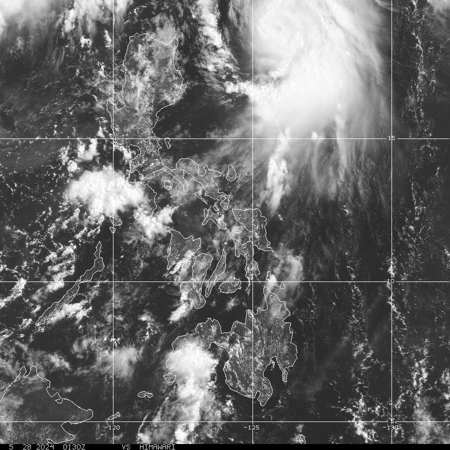
[1] Continued chance of above-average rainfall across Western Luzon &
Western Visayas. Wet conditions are expected in this area as a result of the
onset of the Southwest (SW) Monsoon, ITCZ and areas of above sea surface
temperatures. Confidence: MODERATE.


[2] Continued favorable conditions exist for Tropical Cyclogenesis for the
South China Sea, East of the Philippines (Philippine Sea) & Western Pacific
Ocean.
Active convection & increasingly more prevalent low-level westerly flow
equatorward of this region are expected to gradually lead to more favorable
conditions for Tropical Cyclone development. Confidence: LOW.

--------------------------------------------------------------------------------------

Week Two (2) Forecast: JULY 01-07, 2008 [Tuesday to Monday]
 

[1] Continued chance of above-average rainfall across Western
Philippines.
Wet conditions are expected in this area as a result of the
onset of the Southwest (SW) Monsoon, ITCZ and areas of above sea
surface temperatures. Confidence: LOW.

[2] Continued favorable conditions exist for Tropical Cyclogenesis for
the Philippine Sea & Western Pacific Ocean.
Prevailing convection and
prevalent low-level westerly flow equatorward of this region are expected
to lead to continued favorable conditions for Tropical Cyclone development.
Confidence: MODERATE.


Important Note: Please keep in mind that the above two-week tropical forecast outlook, does not
guarantee 100% accuracy! Errors & changes particularly the 2nd week forecast can happen 
within
the designated outlook week.


> This outlook is issued for planners every Saturday
.

> The next outlook will 
be issued on Tuesday, July 01, 2008.

Sources: NOAA Global Benefits/Hazards Assessment & Various Numerical Computer Models.
_____________________________________________________________________________
>>
To know the meteorological terminologies and acronyms 
   used on this update visit the ff:

    http://typhoon2000.ph/tcterm.htm  
    http://www.nhc.noaa.gov/aboutgloss.shtml
    http://www.srh.noaa.gov/oun/severewx/glossary.php
    http://www.srh.weather.gov/fwd/glossarynation.html
    http://www.nhc.noaa.gov/acronyms.shtml
_____________________________________________________________________________

:: Typhoon2000.com (T2K) Mobile >> 
Powered by: Synermaxx
Receive the latest storm updates directly to your mobile phones! To know more:
Send T2K HELP to: 2800
(GLOBE & TM) | 216 (SMART & TNT) | 2288 (SUN)
 
Note: Globe & Smart charges P2.50 per message, while Sun at P2.00.

_____________________________________________________________________________

Always visit these web addresses for the latest info on Philippine Tropical
Cyclones:

>
http://www.typhoon2000.com
http://www.maybagyo.com

:: Kindly view our site's disclaimer at: 
   
http://www.typhoon2000.ph/disclaimer.htm


Copyright © 2008 Typhoon2000.com All Rights Reserved

__._,_.___
MARKETPLACE

Yahoo! Groups users, check out this limited time offer from Blockbuster! Rent DVDs free for a month!
Recent Activity
Visit Your Group
Cat Zone

on Yahoo! Groups

Join a Group

all about cats.

Yahoo! Groups

Familyographer Zone

Learn how to capture

family moments.

Check out the

Y! Groups blog

Stay up to speed

on all things Groups!

.

__,_._,___

TS FENGSHEN (FRANK) now over Hong Kong [Update #010]


Typhoon2000 STORM UPDATE #010
Name: TROPICAL STORM FENGSHEN [FRANK/07W/0806] 
Issued: 7:00 AM MANILA TIME (23:00 GMT) WED 25 JUNE 2008
Source: HONG KONG OBSERVATORY BULLETIN
Note: Kindly refer to your country's official warnings or bulletins. This update is for additional information purposes only.
_____________________________________________________________________________
 
 
TROPICAL STORM FENGSHEN (FRANK) BATTERS HONG KONG...ITS CENTER HAS
PASSED WITHIN 50 KM EAST OF THE METROPOLIS...MODERATE TO HEAVY RAINS
WITH STRONG WIND GUSTS REACHING 100-130 KM/HR HAVE BEEN OBSERVED IN
SOME AREAS OF HONG KONG PARTICULARLY ALONG STANLEY, CHEUNG CHAU, KAI
TAK AND WAGLAN ISLAND. IN NGONG PING, WIND GUST HAVE REACHED 186 KM/HR
AT 6:30 AM HONG KONG TIME.
 
Click HERE TO VIEW WIND GUST MAP OF HONG KONG!

**Residents of Hong Kong & Eastern Guangdong must take precautionary measures, as
Storm Wind Signal No. 8 remains in effect. Kindly check out
Hong Kong Observatory's
hourly bulletin
on the passage of Tropical Storm FENGSHEN.

+ FORECAST OUTLOOK: FENGSHEN is expected to inland across Eastern
Guangdong, dissipating. The 24-hour forecast calls for further dissi-
pation of FENGSHEN, becoming a Tropical Depression while moving along
Eastern Guangdong tomorrow.

+ EFFECTS: FENGSHEN's core and its western inner bands continues to
lash Hong Kong and Macau. Moderate to heavy rains with wind gusts not
exceeding 120 km/hr can be expected. Meanwhile, its inner bands will
continue to affect the whole of Guangdong province this morning, bri-
nging rains and winds not exceeding 60 km/hr. Residents in low-lying
areas must seek higher grounds for possible flooding & landslides due
to the anticipated heavy rains brought about by this system. Precau-
tionary measures must be implemented today. Coastal Storm Surge floo-
ding of 1 to 3 feet above normal tide levels...along with large and
dangerous battering waves can be expected near and to the north of
FRANK's projected path particularly on where the center makes land-
fall in Eastern Guangdong Province in China. Minimal damage is po-
ssible on this type of storm surge. Far-fetched storm surge is po-
ssible along coastal areas of Western Guangdong and Fujian Province
with surf reaching 1 feet at most.

+ CURRENT MONSOON INTENSITY: The Southwest (SW) Monsoon continues to be
enhanced by FENSGHEN, affecting Western Luzon. Clear to Cloudy skies with
light to moderate passing rains & SW'ly winds not exceeding 40 km/hr may
be expected. Landslides, mudflows (lahars) and flooding is likely to occur
along steep mountain/volcano slopes, river banks, low-lying & flood-prone
areas of the affected areas. Meanwhile, big sea waves or surges generated
by this monsoon can affect the coastal and beach-front areas of the above-
mentioned areas
.

Important Note:
 Please keep in mind that the above forecast outlook,
effects & current monsoon intensity, and tropical cyclone watch changes 
every 06 to 12 hours!
_____________________________________________________________________________

TIME/DATE: 6:00 AM MANILA TIME (22:00 GMT) 25 JUNE
LOCATION OF CENTER: LATITUDE 22.6º N...LONGITUDE 114.4º E
DISTANCE 1: 40 KM (23
NM) NE OF HONG KONG, CHINA 
DISTANCE 2: 95 KM (50 NM) ENE OF MACAU, CHINA 
DISTANCE 3: 250 KM (135 NM) WSW OF SHANTOU, CHINA
DISTANCE 4: 810 KM (437 NM) NW OF LAOAG CITY, PH  
MAX WINDS [1-MIN AVG]: 95 KM/HR (50 KTS) NEAR THE CENTER
PEAK WIND GUSTS: 120 KM/HR (65 KTS)
SAFFIR-SIMPSON SCALE: N/A 
MINIMUM CENTRAL PRESSURE (est.): 985 MILLIBARS (hPa)
RECENT MOVEMENT: NNW @ 14 KM/HR (07 KTS)
GENERAL DIRECTION: SHENZHEN
STORM'S SIZE (IN DIAMETER): 390 KM (210 NM)/AVERAGE
MAX WAVE HEIGHT**: 17 FEET (5.1 METERS)
VIEW TRACKING MAP: 6 AM MANILA TIME TUE JUNE 24
TSR WIND PROBABILITIESCURRENT TO 36 HRS LEAD  
PHILIPPINE STORM SIGNALS*: N/A

12, 24, 36 HR. FORECAST:
2 PM (06 GMT) 25 JUNE: 23.6N 114.8E / 85-100 KPH / N @ 13 KPH
2 AM (18 GMT) 26 JUNE: 25.0N 115.0E / 55-75 KPH / NNE @ 11 KPH
2 PM (06 GMT) 26 JUNE: 26.1N 115.4E / 35-55 KPH / .. @ .. KPH

REMARKS: 2 AM (18 GMT) 25 JUNE POSITION: 22.2N 114.9E.
^TROPICAL STORM (TS) 07W HAS CONTINUED TO TRACK NORTH-NORTHWEST-
WARD AT ABOUT 10 KNOTS OVER THE PAST 12 HOURS UNDER THE INFLUENCE OF
A BROAD STEERING RIDGE TO THE EAST AND NORTHEAST OF THE SYSTEM. THE
TROPICAL STORM HAS NEARLY MAINTAINED INTENSITY DURING THIS TIME
UNDER THE COMPETING INFLUENCES OF MODERATE VERTICAL WIND SHEAR (VWS)
AND STRONG SOUTHWESTWARD OUTFLOW ALOFT. THE NORTHEASTERN PORTION OF
THE LOW LEVEL CIRCULATION CENTER (LLCC) REMAINS EXPOSED, BUT DEEP
CONVECTION HAS PERSISTED ALONG THE SOUTHWESTERN SIDE OF THE LLCC.
SEVERAL RECENT MICROWAVE SATELLITE PASSES INDICATE THAT THE LOW
LEVEL CIRCULATION HAS FURTHER BROADENED ALONG A NORTHEAST TO
SOUTHWEST-ORIENTED AXIS.
..
(more).

>> FENGSHEN {pronounced: feng~shen}, meaning: God of Wind
   
Name contributed by: China.

_____________________________________________________________________________
_____________________________________________________________________________


RECENT HKO TRACKING CHART:


_______________________________________________________________________________________

 
RECENT MTSAT-1R SATELLITE IMAGE:


> Image source:  Digital-Typhoon (http://www.digital-typhoon.org)
__________________________________________________________________________________________

NOTES:
 
  ^ - JTWC commentary remarks (for Meteorologists) from their 
      latest warning.
 
  * - Based on PAGASA's Philippine Storm Warning Signals, 
      # 4 being the highest. For more explanations on these 
      signals, visit:
http://www.typhoon2000.ph/signals.htm

 ** - Based on the Tropical Cyclone's Wave Height near 
      its center.

__________________________________________________________________________________________

>>
To know the meteorological terminologies and acronyms 
   used on this update visit the ff:

    http://typhoon2000.ph/tcterm.htm  
    http://www.nhc.noaa.gov/aboutgloss.shtml
    http://www.srh.noaa.gov/oun/severewx/glossary.php
    http://www.srh.weather.gov/fwd/glossarynation.html
    http://www.nhc.noaa.gov/acronyms.shtml
__________________________________________________________________________________________

:: Typhoon2000.com (T2K) Mobile >> Powered by: Synermaxx
Receive the latest storm updates directly to your mobile phones! To know more:
Send T2K HELP to: 2800
(GLOBE & TM) | 216 (SMART & TNT) | 2288 (SUN) 
Note: Globe & Smart charges P2.50 per message, while Sun at P2.00.
__________________________________________________________________________________________

For the complete details on TS FENGSHEN (FRANK)...go visit
our website @:

>
http://www.typhoon2000.com
http://www.maybagyo.com

:: Kindly view our site's disclaimer at: 
   
http://www.typhoon2000.ph/disclaimer.htm


Copyright © 2008 Typhoon2000.com All Rights Reserved

__._,_.___
MARKETPLACE

Attention, Yahoo! Groups users! Sign up now for a one-month free trial from Blockbuster. Limited time offer.
Recent Activity
Visit Your Group
Curves on Yahoo!

A group for women

to share & discuss

food & weight loss.

Weight Loss Group

on Yahoo! Groups

Get support and

make friends online.

Best of Y! Groups

Discover groups

that are the best

of their class.

.

__,_._,___

Tuesday, June 24, 2008

TS FENGSHEN (FRANK) approaching Southern China [Update #009]


Typhoon2000 STORM UPDATE #009
Name: TROPICAL STORM FENGSHEN [FRANK/07W/0806] 
Issued: 7:00 AM MANILA TIME (23:00 GMT) TUE 24 JUNE 2008
Source: JTWC TROPICAL CYCLONE WARNING #022
Note: Kindly refer to your country's official warnings or bulletins. This update is for additional information purposes only.
_____________________________________________________________________________
 
 
FENGSHEN (FRANK) WEAKENS INTO A TROPICAL STORM AS IT EXITS THE
NORTHWESTERN BORDER OF THE PHILIPPINE AREA OF RESPONSIBILITY (PAR)...
THREATENS SOUTHERN CHINA PARTICULARY EASTERN GUANGDONG PROVINCE...NO
LONGER A THREAT TO THE PHILIPPINES.

+ FORECAST OUTLOOK: FENGSHEN is expected to turn Northward within the
next 24 hours and shall gain strength before making landfall. The 2 to
5-day long-range forecast shows the system making landfall over Eastern
Guangdong in China (passing north of Shantou City) tomorrow morning,
and shall move across Fujian Province tomorrow afternoon - passing to
the north of Xiamen City in the evening, and north of Fuzhou City by
early Thursday morning (June 26). FENGSHEN shall then exit to the East
China Sea on Friday morning, and accelerate Northeastward across the
Sea of Japan, passing in between South Korea & Japan
.

+ EFFECTS: FENGSHEN's main circulation continues to struggle reorganizing
over the South China Sea is no longer affecting Western Philippines
.

+ CURRENT MONSOON INTENSITY: The Southwest (SW) Monsoon continues to be
enhanced by FENSGHEN, affecting Western & Southern Luzon, Mindoro, Bicol
Region, Palawan & Western Visayas. Cloudy skies with light to moderate
passing rains & SW'ly winds not exceeding 40 km/hr may be expected.
Landslides, mudflows (lahars) and flooding is likely to occur along
steep mountain/volcano slopes, river banks, low-lying & flood-prone
areas of the affected areas. Meanwhile, big sea waves or surges gene-
rated by this monsoon can affect the coastal and beach-front areas of
the abovementioned areas. Strong ITCZ (aka. Monsoon Trough) affecting
the whole Philippines - may continue to bring scattered rains and
chances of scattered thunderstorms - most especially in the afternoon
or evening
.

Important Note:
 Please keep in mind that the above forecast outlook,
effects & current monsoon intensity, and tropical cyclone watch changes 
every 06 to 12 hours!
_____________________________________________________________________________

TIME/DATE: 5:00 AM MANILA TIME (23:00 GMT) 24 JUNE
LOCATION OF CENTER: LATITUDE 18.7º N...LONGITUDE 116.2º E {Sat Fix}
DISTANCE 1: 465 KM (250
NM) WNW OF LAOAG CITY, PH 
DISTANCE 2: 440 KM (240 NM) SSE OF HONG KONG, CHINA 
DISTANCE 3: 525 KM (285 NM) SSE OF SHANTOU, CHINA
DISTANCE 4: 610 KM (330 NM) SW OF KAOSHIUNG, CHINA  
MAX WINDS [1-MIN AVG]: 100 KM/HR (55 KTS) NEAR THE CENTER
PEAK WIND GUSTS: 130 KM/HR (70 KTS)
SAFFIR-SIMPSON SCALE: N/A 
MINIMUM CENTRAL PRESSURE (est.): 982 MILLIBARS (hPa)
RECENT MOVEMENT: NW @ 13 KM/HR (07 KTS)
GENERAL DIRECTION: SOUTHERN CHINA
STORM'S SIZE (IN DIAMETER): 500 KM (270 NM)/AVERAGE
MAX WAVE HEIGHT**: 18 FEET (5.4 METERS)
VIEW TRACKING MAP: 2 AM MANILA TIME TUE JUNE 24
TSR WIND PROBABILITIESCURRENT TO 120 HRS LEAD  
PHILIPPINE STORM SIGNALS*: NOW LOWERED

12, 24, 48, 72 HR. FORECAST:
2 PM (06 GMT) 24 JUNE: 20.1N 115.8E / 110-140 KPH / N @ 15 KPH
2 AM (18 GMT) 25 JUNE: 21.7N 115.9E / 100-130 KPH / NNE @ 26 KPH
2 AM (18 GMT) 26 JUNE: 26.0N 119.0E / 85-100 KPH / NE @ 22 KPH
2 AM (18 GMT) 27 JUNE: 29.2N 122.9E / 85-100 KPH / NE @ 26 KPH

REMARKS: 2 AM (18 GMT) 24 JUNE POSITION: 18.5N 116.3E.
^TROPICAL STORM (TS) 07W HAS MAINTAINED INTENSITY OVER THE PAST 12
HOURS. ANIMATED INFRARED SATELLITE IMAGERY SHOWED THAT THE LOW-LEVEL
CIRCULATION CENTER (LLCC) BECAME PARTIALLY-EXPOSED BUT DEEP CONVECT-
ION QUICKLY RE-DEVELOPED OVER THE CENTER DESPITE MODERATE TO STRONG
VERTICAL WIND SHEAR (VWS). A 231136Z SSMIS 37 GHZ MICROWAVE IMAGE
DEPICTED A WELL-DEFINED CENTER WITH IMPROVED CONVECTIVE BANDING. TS
07W HAS TRACKED INCREASINGLY POLEWARD AND IS CURRENTLY TRACKING
NORTHWESTWARD AT 08 KNOTS. THE DYNAMIC MODEL TRACK GUIDANCE HAS
REMAINED CONSISTENT.
..
(more).

>> FENGSHEN {pronounced: feng~shen}, meaning: God of Wind
   
Name contributed by: China.

_____________________________________________________________________________
_____________________________________________________________________________


RECENT WUNDERGROUND.COM T2K TRACKING CHART:


_______________________________________________________________________________________

 
RECENT MTSAT-1R SATELLITE IMAGE:


> Image source:  Digital-Typhoon (http://www.digital-typhoon.org)
__________________________________________________________________________________________

NOTES:
 
  ^ - JTWC commentary remarks (for Meteorologists) from their 
      latest warning.
 
  * - Based on PAGASA's Philippine Storm Warning Signals, 
      # 4 being the highest. For more explanations on these 
      signals, visit:
http://www.typhoon2000.ph/signals.htm

 ** - Based on the Tropical Cyclone's Wave Height near 
      its center.

__________________________________________________________________________________________

>>
To know the meteorological terminologies and acronyms 
   used on this update visit the ff:

    http://typhoon2000.ph/tcterm.htm  
    http://www.nhc.noaa.gov/aboutgloss.shtml
    http://www.srh.noaa.gov/oun/severewx/glossary.php
    http://www.srh.weather.gov/fwd/glossarynation.html
    http://www.nhc.noaa.gov/acronyms.shtml
__________________________________________________________________________________________

:: Typhoon2000.com (T2K) Mobile >> Powered by: Synermaxx
Receive the latest storm updates directly to your mobile phones! To know more:
Send T2K HELP to: 2800
(GLOBE & TM) | 216 (SMART & TNT) | 2288 (SUN) 
Note: Globe & Smart charges P2.50 per message, while Sun at P2.00.
__________________________________________________________________________________________

For the complete details on TS FENGSHEN (FRANK)...go visit
our website @:

>
http://www.typhoon2000.com
http://www.maybagyo.com

:: Kindly view our site's disclaimer at: 
   
http://www.typhoon2000.ph/disclaimer.htm


Copyright © 2008 Typhoon2000.com All Rights Reserved

__._,_.___
MARKETPLACE
Blockbuster is giving away a free trial of Blockbuster Total Access to smart movie lovers like you.
Recent Activity
Visit Your Group
How-To Zone

on Yahoo! Groups

Find garden, home

& auto groups.

Best of Y! Groups

Check out the best

of what Yahoo!

Groups has to offer.

Everyday Wellness

on Yahoo! Groups

Find groups that will

help you stay fit.

.

__,_._,___

Monday, June 23, 2008

Typhoon FENGSHEN (FRANK) now over South China Sea [Update #008]


Typhoon2000 STORM UPDATE #007
Name: TYPHOON FENGSHEN [FRANK/07W/0806] 
Issued: 7:00 AM MANILA TIME (23:00 GMT) MON 23 JUNE 2008
Source: JTWC TROPICAL CYCLONE WARNING #018
Note: Kindly refer to your country's official warnings or bulletins. This update is for additional information purposes only.
_____________________________________________________________________________
 
 
TYPHOON FENGSHEN (FRANK) CONTINUES TO TRY REORGANIZING OVER THE SOUTH
CHINA SEA, DESPITE UNFAVORABLE UPPER LEVEL WINDS (VERTICAL WIND SHEAR)
OVER THE AREA. THE CENTER IS NOW MOVING AWAY FROM WESTERN LUZON...MAY
THREATEN SOUTHERN CHINA OR NORTHWESTERN TAIWAN.

Click
HERE to view zoom past track map on where the typhoon passed over
Luzon!

**Based on actual observation, calm conditions have been observed in Quezon City and
nearby areas of Metro Manila around 6:00-8:00 AM yesterday morning. Latest official
satellite fix confirms that around 7:30 AM (23:30 GMT) June 22 - the cloud-filled EYE
passed over Quezon City.

+ FORECAST OUTLOOK: FENGSHEN is expected to remain a weak Typhoon as it
moves NW'ly across the South China Sea within the next 24 hours. The
2 to 5-day long-range forecast shows the system recurving towards the
NE, and shall pass over Taiwan Strait on Wednesday morning, June 25.
It shall then weaken into a Tropical Storm as it enters the cooler sea
surface temperatures of the East China Sea and begin Extratropical
transition on Thursday, June 26. On Saturday, June 28, FENGSHEN shall
make landfall over Honshu, Japan as an Extratropical Cyclone.

+ EFFECTS: FENGSHEN's main circulation has returned back to sea and is
now reorganizing over the South China Sea, with only its Eastern Outer
(Rain) Bands spreading across Western Luzon. Passing moderate to heavy
rains with winds not exceeding 40 km/hr can be expected within the
outer bands today. Residents in low-lying areas must seek higher
grounds for possible flooding & landslides due to the anticipated heavy
rains brought about by this system. Precautionary measures must remain
implemented today. Far-fetched storm surge is possible along coastal
areas of Western Luzon with surf reaching 2-4 feet at most.

+ CURRENT MONSOON INTENSITY: The Southwest (SW) Monsoon continues to be
enhanced by FENSGHEN, affecting Western & Southern Luzon, Mindoro, Bicol
Region, Palawan & Western Visayas. Cloudy skies with light to moderate
passing rains & SW'ly winds not exceeding 40 km/hr may be expected.
Landslides, mudflows (lahars) and flooding is likely to occur along
steep mountain/volcano slopes, river banks, low-lying & flood-prone
areas of the affected areas. Meanwhile, big sea waves or surges gene-
rated by this monsoon can affect the coastal and beach-front areas of
the abovementioned areas. Strong ITCZ (aka. Monsoon Trough) affecting
the whole Philippines - may continue to bring scattered rains and
chances of scattered thunderstorms - most especially in the afternoon
or evening
.

Important Note:
 Please keep in mind that the above forecast outlook,
effects & current monsoon intensity, and tropical cyclone watch changes 
every 06 to 12 hours!
_____________________________________________________________________________
_____________________________________________________________________________

TIME/DATE: 5:00 AM MANILA TIME (21:00 GMT) 23 JUNE
LOCATION OF CENTER: LATITUDE 16.9º N...LONGITUDE 118.1º E {Sat Fix}
DISTANCE 1: 235 KM (127
NM) WNW OF SAN FERNANDO, LA UNION, PH 
DISTANCE 2: 255 KM (138 NM) WSW OF VIGAN CITY, PH 
DISTANCE 3: 255 KM (138 NM) NW OF DAGUPAN CITY, PH
DISTANCE 4: 300 KM (162 NM) SW OF LAOAG CITY, PH  
DISTANCE 5: 270 KM (145 NM) NW OF IBA, ZAMBALES, PH    
DISTANCE 6: 725 KM (390 NM) SE OF HONG KONG, CHINA    
DISTANCE 7: 410 KM (222 NM) NW OF MANILA, PH    
MAX WINDS [1-MIN AVG]: 120 KM/HR (65 KTS) NEAR THE CENTER
PEAK WIND GUSTS: 150 KM/HR (80 KTS)
SAFFIR-SIMPSON SCALE: CATEGORY ONE (1) 
MINIMUM CENTRAL PRESSURE (est.): 974 MILLIBARS (hPa)
RECENT MOVEMENT: NW @ 22 KM/HR (12 KTS)
GENERAL DIRECTION: SOUTH CHINA SEA
STORM'S SIZE (IN DIAMETER): 445 KM (240 NM)/AVERAGE
MAX WAVE HEIGHT**: 14 FEET (4.2 METERS)
VIEW TRACKING MAP: 2 AM MANILA TIME MON JUNE 23
TSR WIND PROBABILITIESCURRENT TO 120 HRS LEAD  

PHILIPPINE STORM SIGNALS*:
#02 - NORTHERN ZAMBALES, WESTERN PANGASINAN, & LA UNION.
#01 - ILOCOS SUR, ILOCOS NORTE, ABRA, BENGUET, REST OF PANGASINAN, 
      REST OF ZAMBALES, & TARLAC
.

12, 24, 48, 72 HR. FORECAST:
2 PM (06 GMT) 23 JUNE: 18.8N 117.5E / 120-150 KPH / N @ 15 KPH
2 AM (18 GMT) 24 JUNE: 20.4N 117.3E / 120-150 KPH / NNE @ 13 KPH
2 AM (18 GMT) 25 JUNE: 23.2N 119.0E / 120-150 KPH / NE @ 19 KPH
2 AM (18 GMT) 26 JUNE: 26.3N 122.0E / 100-130 KPH / NE @ 19 KPH

REMARKS: 2 AM (18 GMT) 23 JUNE POSITION: 17.1N 118.5E.
^TYPHOON (TY) O7W HAS MAINTAINED INTENSITY FAIRLY WELL OVER THE PAST
12 HOURS AS IT TRACKED OVER WESTERN LUZON. ANIMATED INFRARED SATELLITE
IMAGERY DEPICTS DECREASING CONVECTIVE ORGANIZATION AND A LARGE BURST
OF DEEP CONVECTION SHEARING WESTWARD. HOWEVER, RECENT MICROWAVE
IMAGERY SHOWS CONVECTIVE BANDING WRAPPING INTO THE CENTER WITH WELL-
DEFINED LOW-LEVEL CIRCULATION CENTER (LLCC). SURFACE OBSERVATIONS IN
THE VICINITY OF THE STORM INDICATED MAXIMUM WINDS LESS THAN 20 KNOTS
AND MINIMUM SLP NEAR 994 MB.
..
(more).

>> FENGSHEN {pronounced: feng~shen}, meaning: God of Wind
   
Name contributed by: China.

_____________________________________________________________________________

PAGASA CURRENT POSITION, MOVEMENT AND INTENSITY (10-min. ave.):
 
> 4 AM (20 GMT) 23 JUNE: 16.4N 118.4E / WNW @ 17 KPH / 120 kph

:: For the complete PAGASA bulletin, kindly visit their website at: 
   
http://www.pagasa.dost.gov.ph/wb/tcupdate.shtml
_____________________________________________________________________________


RECENT WUNDERGROUND.COM T2K TRACKING CHART:


_______________________________________________________________________________________

 
RECENT MTSAT-1R SATELLITE IMAGE:


> Image source:  NOAA Satellite and Information Service (http://www.goes.noaa.gov/)
__________________________________________________________________________________________

NOTES:
 
  ^ - JTWC commentary remarks (for Meteorologists) from their 
      latest warning.
 
  * - Based on PAGASA's Philippine Storm Warning Signals, 
      # 4 being the highest. For more explanations on these 
      signals, visit:
http://www.typhoon2000.ph/signals.htm

 ** - Based on the Tropical Cyclone's Wave Height near 
      its center.

__________________________________________________________________________________________

>>
To know the meteorological terminologies and acronyms 
   used on this update visit the ff:

    http://typhoon2000.ph/tcterm.htm  
    http://www.nhc.noaa.gov/aboutgloss.shtml
    http://www.srh.noaa.gov/oun/severewx/glossary.php
    http://www.srh.weather.gov/fwd/glossarynation.html
    http://www.nhc.noaa.gov/acronyms.shtml
__________________________________________________________________________________________

:: Typhoon2000.com (T2K) Mobile >> Powered by: Synermaxx
Receive the latest storm updates directly to your mobile phones! To know more:
Send T2K HELP to: 2800
(GLOBE & TM) | 216 (SMART & TNT) | 2288 (SUN) 
Note: Globe & Smart charges P2.50 per message, while Sun at P2.00.
__________________________________________________________________________________________

For the complete details on TY FENGSHEN (FRANK)...go visit
our website @:

>
http://www.typhoon2000.com
http://www.maybagyo.com

:: Kindly view our site's disclaimer at: 
   
http://www.typhoon2000.ph/disclaimer.htm


Copyright © 2008 Typhoon2000.com All Rights Reserved

__._,_.___
MARKETPLACE

You rock! Blockbuster wants to give you a complimentary trial of - Blockbuster Total Access.
Recent Activity
Visit Your Group
Cat Zone

on Yahoo! Groups

Join a Group

all about cats.

Wellness Spot

Embrace Change

Break the Yo-Yo

weight loss cycle.

Real Food Group

Share recipes,

restaurant ratings

and favorite meals.

.

__,_._,___