Friday, November 30, 2012

Typhoon BOPHA (26W) - Update #014


for Friday, 30 November 2012 [8:41 PM PhT]

WEATHER.COM.PH / T2K TROPICAL CYCLONE UPDATES

TYPHOON BOPHA UPDATE NUMBER 014
Issued: 6:00 PM PhT (10:00 GMT) Friday 30 Nov 2012
Next Update: 6:00 AM PhT (22:00 GMT) Saturday 01 Dec 2012


Bopha becomes a well-developed typhoon as turns west-northwest...Yap and the Republic of Palau under serious threat.

Residents and visitors along Micronesia, Marianas and the Philippines should closely monitor the development of Bopha (26W).

Do not use this for life or death decision. This update is intended for additional information purposes only. Kindly refer to your national weather agency for official warnings, advisories or bulletins.


CURRENT STORM ANALYSIS

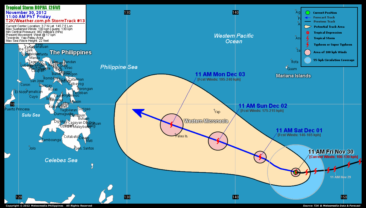
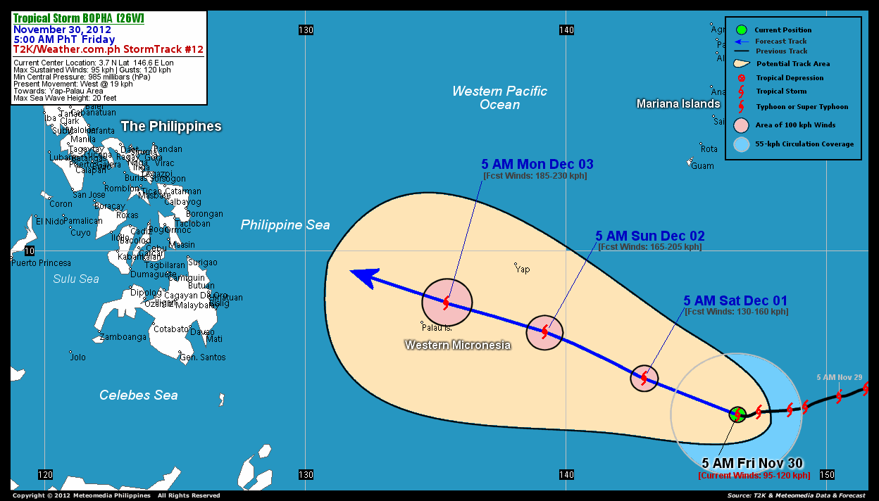
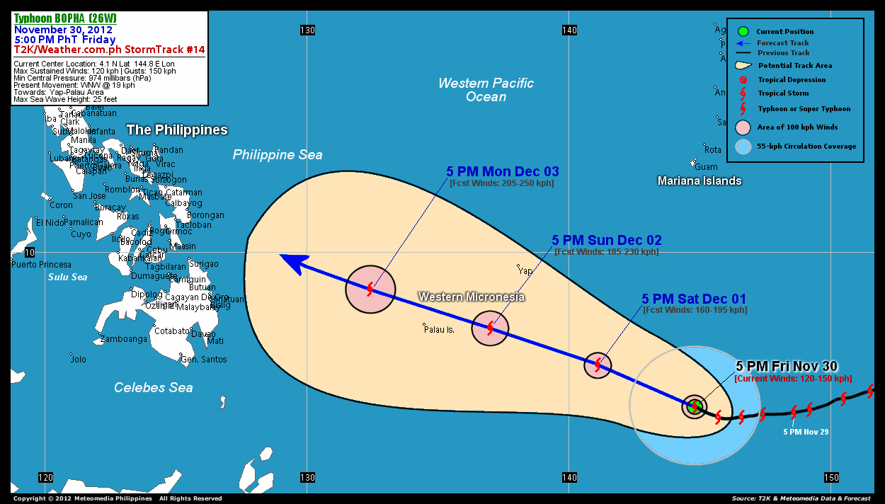
As of 5 pm today, the eye of Typhoon Bopha was located over Central Micronesia...about 952 km southeast of Colonia, Yap or 2,044 km east-southeast of Mindanao, Philippines...currently moving west-northwest with a forward speed of 19 km/hr in the general direction of Yap and Palau Area.

Maximum Sustained Winds (1-min. avg) have increased to 120 km/hr near the center with higher gusts. Tropical Storm Force Winds (62-100 km/hr) extend outward up to 130 kilometers from the center. Bopha is an average-sized tropical cyclone with a diameter of 555 kilometers across. The 24-hour rainfall accumulation near the center of TS Bopha is estimated to be extreme (400 mm).


3-DAY FORECAST OUTLOOK*

Tropical Storm Bopha is expected to continue moving generally west-northwest for the next 24 hours with a slight increase in its forward speed...and this motion will continue during the next 2 to 3 days. On the forecast track, the core of Bopha is expected to continue moving across Central Micronesia through Saturday...approaching Western Micronesia on Sunday morning. The potential typhoon will pass just south of Yap and Ulithi Islands on Sunday afternoon...and very near Palau Islands on Monday early morning, as it enters the Philippine Area of Responsibility (PAR).

Bopha will continue to gain strength throughout the forecast period...and could become a Category 2 Typhoon on Saturday afternoon or evening.

The following is the summary of the 3-day forecast outlook on this system:

SATURDAY AFTERNOON: Strengthens into a Category 2 Typhoon while heading towards Western Micronesia...maintains its WNW track...about 536 km southeast of Colonia, Yap Is., Federated State of Micronesia (FSM) [5PM DEC 01: 5.7N 141.1E @ 160kph].
SUNDAY AFTERNOON: Strengthens into a Category 3 Typhoon as it approaches Western Micronesia...about 276 km east of Koror, Republic of Palau [5PM DEC 02: 7.1N 137.0E @ 185kph].
MONDAY AFTERNOON: Enters the Philippine Area of Responsibility (PAR) as it moves across the Philippine Sea...threatens Eastern Visayas, Philippines...about 279 km northwest of Koror, Palau [5PM DEC 03: 8.6N 132.4E @ 205kph].

*Please be reminded that the Forecast Outlook changes every 6 hours, and the Day 3 Forecast Track have an average error of 250 km...while the wind speed forecast error, averages 35 kph per day. Therefore, a turn to the left or right of its future track and changes in its wind speed must be anticipated from time to time.


EFFECTS & HAZARDS SUMMARY

Below is the summary of the storm's parts and its hazards affecting specific areas. You can also view this image link for you to understand the parts.

CLOUD-FILLED EYE - over water (Western Pacific Ocean). Possible calm and lull conditions (with <20 kph winds) will be expected inside the eye (click here to know more about the EYE).
EYEWALL - over water (Western Pacific Ocean)...not yet affecting any land areas.. Typhoon Conditions with Typhoon Force Winds (>118 kph) will be expected within this wall (click here to know more about the Eyewall).
INNER RAINBANDS - affecting and spreading across the smaller islands of Central Micronesia. Tropical Storm Conditions with Tropical Storm Force Winds (62-117 kph) will be expected along these bands.
OUTER RAINBANDS - affecting and spreading across the smaller islands of Central Micronesia. Tropical Depression Conditions with moderate to strong winds (<62 kph) will be expected along these bands (click here to know more about Rainbands).
24HR TOTAL RAINFALL ACCUMULATION - from 5 up to 200 mm (slight to heavy rainfall) can be expected along areas affected by the outer & inner rainbands (see above)...with isolated amounts of 201 to 500 mm (heavy to extreme) along areas near the center of Bopha.
COASTAL STORM SURGE FLOODING - possible 4-5 ft (1.2-1.7 m) above normal tide levels...accompanied by large and dangerous battering waves can be expected along the coastal, inland lakes and beach front areas of Central Micronesia. Minimal damage is likely on this type of storm surge. Danger from Rip Currents or Rip Tides can be expected along the rest of the beach-front areas of Western Micronesia and the Marianas (click here to know more about Storm Surge).

Important Note: Please keep in mind that the above forecast outlook, effects and hazards summary changes every 6 to 12 hrs!


CURRENT TECHNICAL INFORMATION

Time/Date: 5:00 PM PhT Fri November 30, 2012
Class/Name: TY Bopha (26W)
Location of Eye: 4.1º N Lat 144.8º E Lon
Distance 1: 952 km (SE) from Colonia, Yap
Distance 2: 1,045 km (S) from Hagatna, Guam
Distance 3: 1,087 km (E) from the P.A.R.
Distance 4: 1,190 km (ESE) from Koror, Palau
Distance 5: 2,044 km (ESE) from Mindanao, PH
Distance 6: 2,265 km (SE) from Samar, PH
Distance 7: 2,477 km (SE) from Bicol Region, PH
MaxWinds (1-min avg): 120 kph near the center
Peak Wind Gusts: 150 kph
Saffir-Simpson Hurricane Scale: Category 1
Present Movement: WNW @ 19 kph
Towards: Yap-Palau Area
24hr Rainfall Accum (near center): Extreme [400 mm]
Minimum Central Pressure: 974 millibars (hPa)
Size (in Diameter): 555 km [Average]
Max Sea Wave Height (near center): 25 feet
Possible Storm Surge Height: 4-5 ft (1.2-1.7 m)

T2K/WP StormTracks (for Public): GIF | Google Map (Flash)

__________________________________________________________________________________________________

CURRENT NOAA/MTSAT-2 SATELLITE ANIMATION:

http://www.ssd.noaa.gov/PS/TROP/floaters/26W/imagery/rgb-animated.gif


CURRENT NOAA/MTSAT-2 INFRARED SATELLITE IMAGE
:

http://www.ssd.noaa.gov/PS/TROP/floaters/26W/imagery/rb0-lalo.jpg


CURRENT TRACKING CHART:


http://www.typhoon2000.ph/advisorytrax/2012/pablo14.gif

_____________________________________________________________________________


NOTE:

>> To know the meteorological terminologies and acronyms used on this update visit the ff:

   
http://typhoon2000.ph/tcterm.htm  
   
http://www.nhc.noaa.gov/aboutgloss.shtml
    http://www.nhc.noaa.gov/acronyms.shtml
__________________________________________________________________________________________

For the complete details on TY BOPHA...go visit our website @:

>
http://www.typhoon2000.com
http://www.maybagyo.com

:: Kindly view our site's disclaimer at: 
   
http://www.typhoon2000.ph/disclaimer.htm
__________________________________________________________________________________________

<<<Typhoon2000.com Mobile >>>
Get the latest SMS Storm Alerts!
For more details: Text T2K TYPHOON to

2800 (Globe/TM) | 216 (Smart/TNT) | 2288 (Sun)
*Only P2.50 (Smart/Globe) / P2.00 (Sun) per msg received.

Click here on how to use this service (in PDF file)
Powered by: Synermaxx Corporation


Copyright © 2012 Typhoon2000.com     All Rights Reserved

__._,_.___
Reply via web post Reply to sender Reply to group Start a New Topic Messages in this topic (1)
Recent Activity:
.

__,_._,___

TS BOPHA (26W) - Update #013


for Friday, 30 November 2012 [12:18 PM PhT]

WEATHER.COM.PH / T2K TROPICAL CYCLONE UPDATES

TROPICAL STORM BOPHA UPDATE NUMBER 013
Issued: 12:00 NN PhT (04:00 GMT) Friday 30 Nov 2012
Next Update: 6:00 PM PhT (10:00 GMT) Friday 30 Nov 2012


Tropical Storm Bopha has slightly gained strength as it moves towards Yap and the Republic of Palau.

Residents and visitors along Micronesia, Marianas and the Philippines should closely monitor the development of Bopha (26W).

Do not use this for life or death decision. This update is intended for additional information purposes only. Kindly refer to your national weather agency for official warnings, advisories or bulletins.


CURRENT STORM ANALYSIS

As of 11 am today, the center of Tropical Storm Bopha was located over Central Micronesia...about 1,095 km south of Hagatna, Guam or 2,150 km east-southeast of Mindanao, Philippines...currently moving west with a forward speed of 17 km/hr in the general direction of Yap and Palau Area.

Maximum Sustained Winds (1-min. avg) have increased to 100 km/hr near the center with higher gusts. Tropical Storm Force Winds (62-100 km/hr) extend outward up to 120 kilometers from the center. Bopha is an average-sized tropical cyclone with a diameter of 555 kilometers across. The 24-hour rainfall accumulation near the center of TS Bopha is estimated to be extreme (500 mm).


3-DAY FORECAST OUTLOOK*

Tropical Storm Bopha is expected to turn west-northwest for the next 12 to 24 hours with a slight forward speed...and this motion will continue during the next 2 to 3 days. On the forecast track, the core of Bopha is expected to continue moving across Central Micronesia through Saturday...approaching Western Micronesia on Sunday morning. The potential typhoon will pass just south of Yap and Ulithi Islands by noon of Sunday...and very near Palau Islands on Monday morning as Bopha enters the Philippine Area of Responsibility (PAR).

Bopha will continue to gain strength throughout the forecast period...and could become a Typhoon later this afternooon or tonight.

The following is the summary of the 3-day forecast outlook on this system:

SATURDAY MORNING: Strengthens into a Typhoon while moving across Central Micronesia...turns sharply WNW...about 674 km southeast of Colonia, Yap Is., Federated State of Micronesia (FSM) [11AM DEC 01: 5.1N 142.3E @ 140kph].
SUNDAY MORNING: Upgraded to a Category 2 Typhoon as it approaches Western Micronesia...about 324 km south of Colonia, Yap Is., FSM [11AM DEC 02: 6.6N 138.4E @ 175kph].
MONDAY MORNING: Upgraded to a Category 3 Typhoon as it moves away from the Republic of Palau...enters the Philippine Area of Responsibility (PAR)...about 109 km north-northwest of Koror, Palau [11AM DEC 03: 8.1N 134.1E @ 195kph].

*Please be reminded that the Forecast Outlook changes every 6 hours, and the Day 3 Forecast Track have an average error of 250 km...while the wind speed forecast error, averages 35 kph per day. Therefore, a turn to the left or right of its future track and changes in its wind speed must be anticipated from time to time.


EFFECTS & HAZARDS SUMMARY

Below is the summary of the storm's parts and its hazards affecting specific areas. You can also view this image link for you to understand the parts.

CENTRAL DENSE OVERCAST (CDO) - over water (West Pacific Ocean)...possible "Eye" may be forming underneath the cirrus canopy. Near-Typhoon Conditions w/ Near-Typhoon Force Winds (100-130 kph) will be expected along the CDO (click here to know more about CDO).
INNER RAINBANDS - affecting and spreading across the smaller islands of Central Micronesia. Tropical Storm Conditions with Tropical Storm Force Winds (62-117 kph) will be expected along these bands.
OUTER RAINBANDS - affecting and spreading across the smaller islands of Central Micronesia. Tropical Depression Conditions with moderate to strong winds (<62 kph) will be expected along these bands (click here to know more about Rainbands).
24HR TOTAL RAINFALL ACCUMULATION - from 5 up to 200 mm (slight to heavy rainfall) can be expected along areas affected by the outer & inner rainbands (see above)...with isolated amounts of 201 to 500 mm (heavy to extreme) along areas near the center of Bopha.

Important Note: Please keep in mind that the above forecast outlook, effects and hazards summary changes every 6 to 12 hrs!


CURRENT TECHNICAL INFORMATION

Time/Date: 11:00 AM PhT Fri November 30, 2012
Class/Name: TS Bopha (26W)
Location of Center: 3.7º N Lat 145.7º E Lon
Distance 1: 1,095 km (S) from Hagatna, Guam
Distance 2: 1,058 km (SE) from Colonia, Yap
Distance 3: 1,187 km (E) from the P.A.R.
Distance 4: 1,300 km (ESE) from Koror, Palau
Distance 5: 2,150 km (ESE) from Mindanao, PH
Distance 6: 2,373 km (SE) from Samar, PH
Distance 7: 2,587 km (SE) from Bicol Region, PH
MaxWinds (1-min avg): 100 kph near the center
Peak Wind Gusts: 130 kph
Present Movement: West @ 17 kph
Towards: Yap-Palau Area
24hr Rainfall Accum (near center): Extreme [500 mm]
Minimum Central Pressure: 982 millibars (hPa)
Size (in Diameter): 555 km [Average]
Max Sea Wave Height (near center): 22 feet
Possible Storm Surge Height: 1-3 ft (0.3-0.9 m)

T2K/WP StormTracks (for Public): GIF | Google Map (Flash)

__________________________________________________________________________________________________

CURRENT NOAA/MTSAT-2 SATELLITE ANIMATION:

http://www.ssd.noaa.gov/PS/TROP/floaters/26W/imagery/rgb-animated.gif


CURRENT NOAA/MTSAT-2 INFRARED SATELLITE IMAGE
:

http://www.ssd.noaa.gov/PS/TROP/floaters/26W/imagery/rb0-lalo.jpg


CURRENT TRACKING CHART:


http://www.typhoon2000.ph/advisorytrax/2012/pablo13.gif

_____________________________________________________________________________


NOTE:

>> To know the meteorological terminologies and acronyms used on this update visit the ff:

   
http://typhoon2000.ph/tcterm.htm  
   
http://www.nhc.noaa.gov/aboutgloss.shtml
    http://www.nhc.noaa.gov/acronyms.shtml
__________________________________________________________________________________________

For the complete details on TS BOPHA...go visit our website @:

>
http://www.typhoon2000.com
http://www.maybagyo.com

:: Kindly view our site's disclaimer at: 
   
http://www.typhoon2000.ph/disclaimer.htm
__________________________________________________________________________________________

<<<Typhoon2000.com Mobile >>>
Get the latest SMS Storm Alerts!
For more details: Text T2K TYPHOON to

2800 (Globe/TM) | 216 (Smart/TNT) | 2288 (Sun)
*Only P2.50 (Smart/Globe) / P2.00 (Sun) per msg received.

Click here on how to use this service (in PDF file)
Powered by: Synermaxx Corporation


Copyright © 2012 Typhoon2000.com     All Rights Reserved

__._,_.___
Reply via web post Reply to sender Reply to group Start a New Topic Messages in this topic (1)
Recent Activity:
.

__,_._,___

TS BOPHA (26W) - Update #012


for Friday, 30 November 2012 [7:06 AM PhT]

WEATHER.COM.PH / T2K TROPICAL CYCLONE UPDATES

TROPICAL STORM BOPHA UPDATE NUMBER 012
Issued: 6:00 AM PhT (22:00 GMT) Friday 30 Nov 2012
Next Update: 12:00 NN PhT (04:00 GMT) Friday 30 Nov 2012


Tropical Storm Bopha continues to move westward across Central Micronesia...slowly intensifying...forecast to reach Palau Islands early Monday morning.

Residents and visitors along Micronesia, Marianas and the Philippines should closely monitor the development of Bopha (26W).

Do not use this for life or death decision. This update is intended for additional information purposes only. Kindly refer to your national weather agency for official warnings, advisories or bulletins.


CURRENT STORM ANALYSIS

As of 5 am today, the center of Tropical Storm Bopha was located over Central Micronesia...about 1,107 km south-southeast of Hagatna, Guam or 2,250 km east-southeast of Mindanao, Philippines...currently moving west with a forward speed of 19 km/hr in the general direction of Yap and Palau Area.

Maximum Sustained Winds (1-min. avg) remain at 95 km/hr near the center with higher gusts. Tropical Storm Force Winds (62-100 km/hr) extend outward up to 100 kilometers from the center. Bopha is an average-sized tropical cyclone with a diameter of 555 kilometers across. The 24-hour rainfall accumulation near the center of TS Bopha is estimated to be extreme (500 mm).


3-DAY FORECAST OUTLOOK*

Tropical Storm Bopha is expected to continue moving westward for the next 12 hours...with a gradual turn to the west-northwest during the next 48 to 72 hours. On the forecast track, the core of Bopha is expected to move across Central Micronesia through Saturday...approaching Western Micronesia on Sunday morning. The potential typhoon will pass just south of Yap and Ulithi Islands on Sunday afternoon...and near Palau Islands Monday morning. Bopha may enter the Philippine Area of Responsibility (PAR) approximately between 7-8 am Manila Time on Monday.

Bopha is expected to gain strength throughout the forecast period...and may become a Typhoon tonight.

The following is the summary of the 3-day forecast outlook on this system:

SATURDAY MORNING: Strengthens into a Typhoon while moving across Central Micronesia...turns sharply WNW...about 729 km southeast of Colonia, Yap Is., Federated State of Micronesia (FSM) [5AM DEC 01: 5.1N 143.0E @ 130kph].
SUNDAY MORNING: Upgraded to a Category 2 Typhoon as it approaches Western Micronesia...about 313 km south-southeast of Colonia, Yap Is., FSM [5AM DEC 02: 6.9N 139.2E @ 165kph].
MONDAY MORNING: Upgraded to a Category 3 Typhoon as it passes close to Palau Islands...approaching the Philippine Area of Responsibility (PAR)...about 133 km northeast of Koror [5AM DEC 03: 8.0N 135.4E @ 185kph].

*Please be reminded that the Forecast Outlook changes every 6 hours, and the Day 3 Forecast Track have an average error of 250 km...while the wind speed forecast error, averages 35 kph per day. Therefore, a turn to the left or right of its future track and changes in its wind speed must be anticipated from time to time.


EFFECTS & HAZARDS SUMMARY

Below is the summary of the storm's parts and its hazards affecting specific areas. You can also view this image link for you to understand the parts.

CENTRAL DENSE OVERCAST (CDO) - over water (West Pacific Ocean)...possible "Eye" may be forming underneath the cirrus canopy. Near-Typhoon Conditions w/ Near-Typhoon Force Winds (95-120 kph) will be expected along the CDO (click here to know more about CDO).
INNER RAINBANDS - affecting and spreading across the smaller islands of Central Micronesia. Tropical Storm Conditions with Tropical Storm Force Winds (62-117 kph) will be expected along these bands.
OUTER RAINBANDS - affecting and spreading across the smaller islands of Central Micronesia. Tropical Depression Conditions with moderate to strong winds (<62 kph) will be expected along these bands (click here to know more about Rainbands).
24HR TOTAL RAINFALL ACCUMULATION - from 5 up to 200 mm (slight to heavy rainfall) can be expected along areas affected by the outer & inner rainbands (see above)...with isolated amounts of 201 to 500 mm (heavy to extreme) along areas near the center of Bopha.

Important Note: Please keep in mind that the above forecast outlook, effects and hazards summary changes every 6 to 12 hrs!


CURRENT TECHNICAL INFORMATION

Time/Date: 5:00 AM PhT Fri November 30, 2012
Class/Name: TS Bopha (26W)
Location of Center: 3.7º N Lat 146.6º E Lon
Distance 1: 1,107 km (SSE) from Hagatna, Guam
Distance 2: 1,139 km (SE) from Colonia, Yap
Distance 3: 1,287 km (E) from the P.A.R.
Distance 4: 1,394 km (ESE) from Koror, Palau
Distance 5: 2,250 km (ESE) from Mindanao, PH
Distance 6: 2,495 km (SE) from Samar, PH
Distance 7: 2,677 km (SE) from Bicol Region, PH
MaxWinds (1-min avg): 95 kph near the center
Peak Wind Gusts: 120 kph
Present Movement: West @ 19 kph
Towards: Yap-Palau Area
24hr Rainfall Accum (near center): Extreme [500 mm]
Minimum Central Pressure: 985 millibars (hPa)
Size (in Diameter): 555 km [Average]
Max Sea Wave Height (near center): 20 feet
Possible Storm Surge Height: 1-3 ft (0.3-0.9 m)

T2K/WP StormTracks (for Public): GIF | Google Map (Flash)

__________________________________________________________________________________________________

CURRENT NOAA/MTSAT-2 SATELLITE ANIMATION:

http://www.ssd.noaa.gov/PS/TROP/floaters/26W/imagery/rgb-animated.gif


CURRENT NOAA/MTSAT-2 INFRARED SATELLITE IMAGE
:

http://www.ssd.noaa.gov/PS/TROP/floaters/26W/imagery/rb0-lalo.jpg


CURRENT TRACKING CHART:


http://www.typhoon2000.ph/advisorytrax/2012/pablo12.gif

_____________________________________________________________________________


NOTE:

>> To know the meteorological terminologies and acronyms used on this update visit the ff:

   
http://typhoon2000.ph/tcterm.htm  
   
http://www.nhc.noaa.gov/aboutgloss.shtml
    http://www.nhc.noaa.gov/acronyms.shtml
__________________________________________________________________________________________

For the complete details on TS BOPHA...go visit our website @:

>
http://www.typhoon2000.com
http://www.maybagyo.com

:: Kindly view our site's disclaimer at: 
   
http://www.typhoon2000.ph/disclaimer.htm
__________________________________________________________________________________________

<<<Typhoon2000.com Mobile >>>
Get the latest SMS Storm Alerts!
For more details: Text T2K TYPHOON to

2800 (Globe/TM) | 216 (Smart/TNT) | 2288 (Sun)
*Only P2.50 (Smart/Globe) / P2.00 (Sun) per msg received.

Click here on how to use this service (in PDF file)
Powered by: Synermaxx Corporation


Copyright © 2012 Typhoon2000.com     All Rights Reserved

__._,_.___
Reply via web post Reply to sender Reply to group Start a New Topic Messages in this topic (1)
Recent Activity:
.

__,_._,___