
WEATHER.COM.PH / T2K TROPICAL CYCLONE UPDATES
TROPICAL STORM BOPHA UPDATE NUMBER 010
Issued: 12:00 NN PhT (04:00 GMT) Thursday 29 Nov 2012
Next Update: 6:00 PM PhT (10:00 GMT) Thursday 29 Nov 2012
Tropical Storm Bopha continues to move west-southwest across Central Micronesia...farther away from Chuuk Islands. Forecast to reach Palau Islands on Sunday.
Residents and visitors along Micronesia, Marianas and the Philippines should closely monitor the development of Bopha (26W).
Do not use this for life or death decision. This update is intended for additional information purposes only. Kindly refer to your national weather agency for official warnings, advisories or bulletins.
CURRENT STORM ANALYSIS
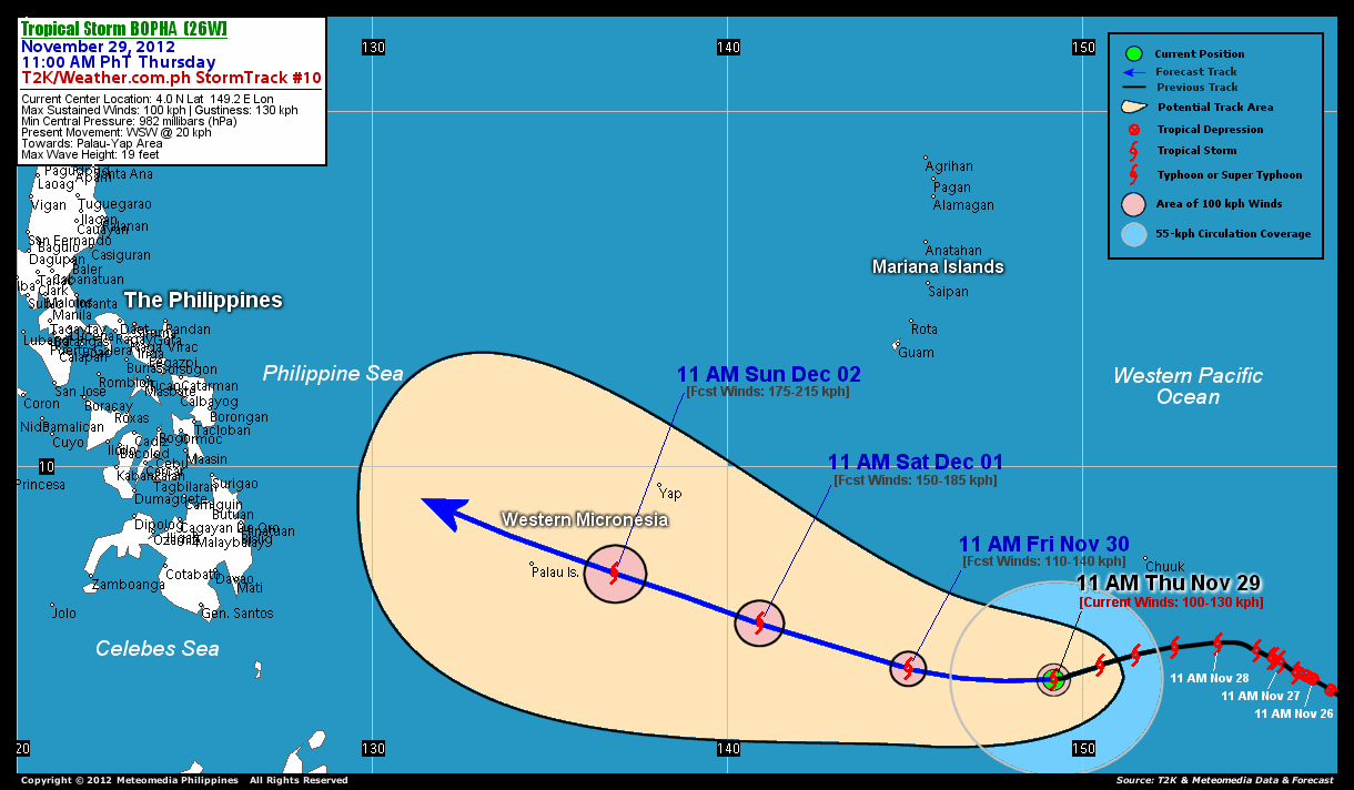
As of 11 am today, the center of Tropical Storm Bopha was located over Central Micronesia...about 475 km southwest of Chuuk Islands, Micronesia or 2,527 km east-southeast of Mindanao, Philippines...currently moving west-southwest with a forward speed of 20 km/hr in the general direction of Yap and Palau Area.
Maximum Sustained Winds (1-min. avg) are at 100 km/hr near the center with higher gusts. Tropical Storm Force Winds (62-100 km/hr) extend outward up to 100 kilometers from the center. Bopha is an average-sized tropical cyclone with a diameter of 555 kilometers across. The 24-hour rainfall accumulation near the center of TS Bopha is estimated to be heavy (350 mm).
3-DAY FORECAST OUTLOOK*
Tropical Storm Bopha is expected to resume moving westward for the next 24 hours...with a west-northwest turn during the next 48 to 72 hours. On the forecast track, the core of Bopha is expected to move across Central and Western Micronesia thru Saturday morning...approaching Palau Islands on Sunday morning.
Bopha is expected to intensify throughout the forecast period...and may become a Typhoon on Friday.
The following is the summary of the 3-day forecast outlook on this system:
 FRIDAY MORNING: Almost a typhoon as it moves across Central Micronesia...about 965 km southeast of Colonia, Yap Is., FSM [11AM NOV 30: 4.3N 145.1E @ 110kph].
SATURDAY MORNING: Continues to stengthen while moving closer to Western Micronesia...about 532 km southeast of Colonia, Yap Is., FSM [11AM DEC 01: 5.6N 140.9E @ 150kph].
SUNDAY MORNING: Intensifies into a Category 2 Typhoon as it approaches Palau Islands...about 256 km east of Koror, Palau [11AM DEC 02: 7.0N 136.8E @ 175kph].
*Please be reminded that the Forecast Outlook changes every 6 hours, and the Day 3 Forecast Track have an average error of 250 km...while the wind speed forecast error, averages 35 kph per day. Therefore, a turn to the left or right of its future track and changes in its wind speed must be anticipated from time to time.
EFFECTS & HAZARDS SUMMARY
Below is the summary of the storm's parts and its hazards affecting specific areas. You can also view this image link for you to understand the parts.
CENTRAL DENSE OVERCAST (CDO) - over water (West Pacific Ocean)...possible "Eye" may be forming underneath the cirrus canopy. Near-Typhoon Conditions w/ Near-Typhoon Force Winds (100-130 kph) will be expected along the CDO (click here to know more about CDO). INNER RAINBANDS - over water (Western Pacific Ocean)...not affecting any land areas. Tropical Storm Conditions with Tropical Storm Force Winds (62-117 kph) will be expected along these bands. OUTER RAINBANDS - affecting and spreading across portions of Eastern and Central Micronesia (including Chuuk Islands). Tropical Depression Conditions with moderate to strong winds (<62 kph) will be expected along these bands (click here to know more about Rainbands). 24HR TOTAL RAINFALL ACCUMULATION - from 5 up to 200 mm (slight to heavy rainfall) can be expected along areas affected by the outer & inner rainbands (see above)...with isolated amounts of 201 to 350 mm (heavy) along areas near the center of Bopha.
Important Note: Please keep in mind that the above forecast outlook, effects and hazards summary changes every 6 to 12 hrs!
CURRENT TECHNICAL INFORMATION
Time/Date: 11:00 AM PhT Thu November 29, 2012
Class/Name: TS Bopha (26W)
Location of Center: 4.0º N Lat 149.2º E Lon
Distance 1: 475 km (SW) away from Chuuk Is., FSM
Distance 2: 1,150 km (SSE) closer to Guam, CNMI
Distance 3: 1,370 km (SE) closer to Colonia, Yap
Distance 4: 1,575 km (E) closer to P.A.R.
Distance 5: 1,667 km (ESE) closer to Koror, Palau
Distance 6: 2,527 km (ESE) closer to Mindanao, PH
Distance 7: 3,045 km (SE) closer to Metro Naga, PH
MaxWinds (1-min avg): 100 kph near the center
Peak Wind Gusts: 130 kph
Present Movement: WSW @ 20 kph
Towards: Yap-Palau Area
24hr Rainfall Accum (near center): Heavy [350 mm]
Minimum Central Pressure: 982 millibars (hPa)
Size (in Diameter): 555 km [Average]
Max Sea Wave Height (near center): 19 feet
Possible Storm Surge Height: 1-3 ft (0.3-0.9 m)
T2K/WP StormTracks (for Public): GIF | Google Map (Flash)

CURRENT NOAA/MTSAT-2 INFRARED SATELLITE IMAGE:

CURRENT TRACKING CHART:
_____________________________________________________________________________
>> To know the meteorological terminologies and acronyms used on this update visit the ff:
http://typhoon2000.ph/tcterm.htm
http://www.nhc.noaa.gov/aboutgloss.shtml
http://www.nhc.noaa.gov/acronyms.shtml
__________________________________________________________________________________________
For the complete details on TS BOPHA...go visit our website @:
> http://www.typhoon2000.com
> http://www.maybagyo.com
<<<Typhoon2000.com Mobile >>>
Get the latest SMS Storm Alerts!
For more details: Text T2K TYPHOON to
2800 (Globe/TM) | 216 (Smart/TNT) | 2288 (Sun)
*Only P2.50 (Smart/Globe) / P2.00 (Sun) per msg received.
Click here on how to use this service (in PDF file)
Powered by: Synermaxx Corporation
Copyright © 2012 Typhoon2000.com All Rights Reserved
| Reply via web post | Reply to sender | Reply to group | Start a New Topic | Messages in this topic (1) |

No comments:
Post a Comment