
WEATHER.COM.PH / T2K TROPICAL CYCLONE UPDATES
TROPICAL DEPRESSION 25W (UNNAMED) UPDATE NUMBER 001
Issued: 12:00 MN PhT (16:00 GMT) Thursday 15 Nov 2012
Next Update: 6:00 AM PhT (22:00 GMT) Thursday 15 Nov 2012
The strong disturbance (LPA) off the South China Sea, near the coast of Southern Vietnam has become Tropical Depression 25W (Unnamed)...approaching the southern tip of Vietnam. Its rainbands continues to spread across the southern portions of Vietnam and Cambodia.
Residents and visitors along Southern Vietnam and Southern Thailand should closely monitor the development of 25W.
Do not use this for life or death decision. This update is intended for additional information purposes only. Kindly refer to your national weather agency for official warnings, advisories or bulletins.
CURRENT STORM ANALYSIS
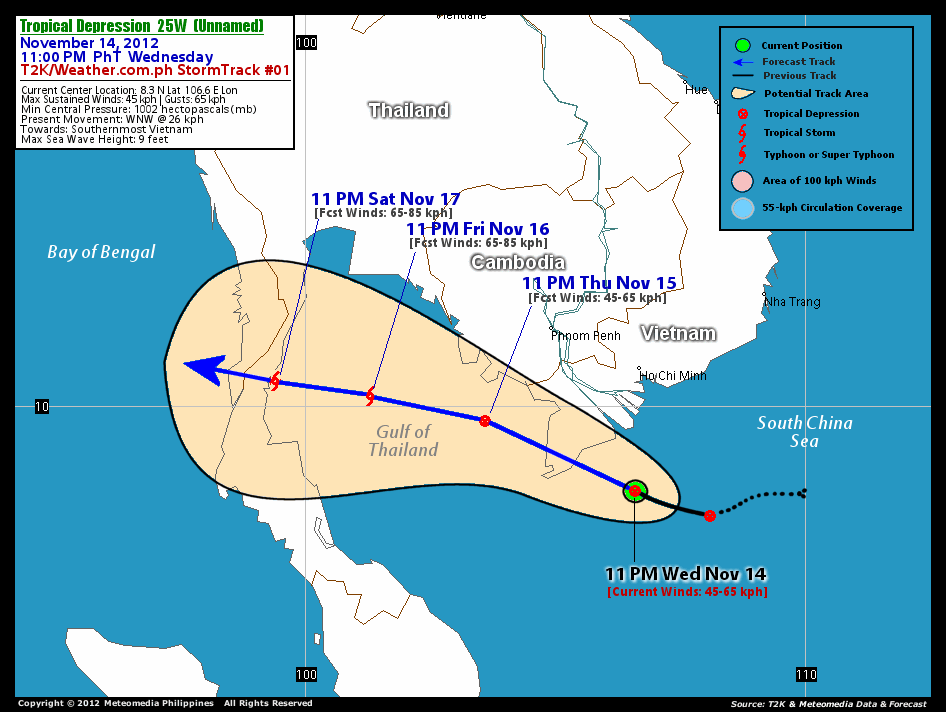
As of 11 pm today, the center of Tropical Depression 25W was located near the southernmost point of Vietnam...about 245 km south of Ho Chi Minh City, Vietnam or 382 km south-southeast of Phnom Penh City, Cambodia...currently moving west-northwest with a forward speed of 24 km/hr in the general direction of the Southern tip of Vietnam.
Maximum Sustained Winds (1-min. avg) are at 45 km/hr near the center with higher gusts. . The 24-hour rainfall accumulation near and to the north of the center of TD 25W is estimated to be heavy (220 mm).
3-DAY FORECAST OUTLOOK*
Tropical Depression 25W is expected to move slowly west-northwest during the next 24 hours...with a turn to the west between 36 to 48 hours. By 72 hours, 25W may resume its west-northwest movement. On the forecast track, the core of 25W is expected to pass over the Southern tip of Vietnam on Thursday morning...and emerge across the Gulf of Thailand Thursday evening thru Saturday. TD 25W will cut across the southern part of Thailand by late Saturday evening.
TD 25W is expected to slowly intensify during the next 24 to 48 hours...and could become a Tropical Storm on Friday evening.
The following is the summary of the 3-day forecast outlook on this system:
 THURSDAY EVENING: Emerging over the Gulf of Thailand after passing over the Southern tip of Vietnam...about 225 km south-southwest of Phnom Penh, Cambodia [11PM NOV 15: 9.7N 103.6E @ 45kph].
FRIDAY EVENING: Strengthens into a Tropical Storm as it moves across the Gulf of Thailand...about 221 km east of Southern Thailand [11PM NOV 16: 10.2N 101.3E @ 65kph].
SATURDAY EVENING: Just along the east coast of Southern Thailand...maintains its Tropical Storm status [11PM NOV 17: 10.5N 99.4E @ 65kph].
*Please be reminded that the Forecast Outlook changes every 6 hours, and the Day 3 Forecast Track have an average error of 250 km...while the wind speed forecast error, averages 35 kph per day. Therefore, a turn to the left or right of its future track and changes in its wind speed must be anticipated from time to time.
EFFECTS & HAZARDS SUMMARY
Below is the summary of the storm's parts and its hazards affecting specific areas. You can also view this image link for you to understand the parts.
RAINBANDS - affecting and spreading across Southern parts of Vietnam and Cambodia. Tropical Depression Conditions with moderate to strong winds (<62 kph) will be expected along these bands (click here to know more about Rainbands). 24HR TOTAL RAINFALL ACCUMULATION - from 5 up to 100 mm (slight to heavy rainfall) can be expected along areas affected by the outer & inner rainbands (see above)...with isolated amounts of 201 to 220 mm (heavy) along areas near and to the north of the center of 25W.
Important Note: Please keep in mind that the above forecast outlook, effects and hazards summary changes every 6 to 12 hrs!
CURRENT TECHNICAL INFORMATION
Time/Date: 11:00 PM PhT Wed November 14, 2012
Class/Name: TD 25W (Unnamed)
Location of Center: 8.3º N Lat 106.6º E Lon
Distance 1: 245 km (S) closer to Ho Chi Minh, Vietnam
Distance 2: 382 km (SSE) closer to Phnom Penh, Cambodia
Distance 3: 187 km (E) closer to the Southern tip of Vietnam
MaxWinds (1-min avg): 45 kph near the center
Peak Wind Gusts: 65 kph
Present Movement: WNW @ 26 kph
Towards: Southern Tip of Vietnam
24hr Rainfall Accum (near center): Heavy [220 mm]
Minimum Central Pressure: 1002 millibars (hPa)
Size (in Diameter): --- km [N/A]
Max Sea Wave Height (near center): XX feet
Possible Storm Surge Height: 0 ft (0 m)
T2K/WP StormTracks (for Public): GIF | Google Map (Flash)

CURRENT NOAA/MTSAT-2 INFRARED SATELLITE IMAGE:

CURRENT TRACKING CHART:
_____________________________________________________________________________
>> To know the meteorological terminologies and acronyms used on this update visit the ff:
http://typhoon2000.ph/tcterm.htm
http://www.nhc.noaa.gov/aboutgloss.shtml
http://www.nhc.noaa.gov/acronyms.shtml
__________________________________________________________________________________________
For the complete details on TD 25W (UNNAMED)...go visit our website @:
> http://www.typhoon2000.com
> http://www.maybagyo.com
<<<Typhoon2000.com Mobile >>>
Get the latest SMS Storm Alerts!
For more details: Text T2K TYPHOON to
2800 (Globe/TM) | 216 (Smart/TNT) | 2288 (Sun)
*Only P2.50 (Smart/Globe) / P2.00 (Sun) per msg received.
Click here on how to use this service (in PDF file)
Powered by: Synermaxx Corporation
Copyright © 2012 Typhoon2000.com All Rights Reserved
| Reply via web post | Reply to sender | Reply to group | Start a New Topic | Messages in this topic (1) |

No comments:
Post a Comment