
WEATHER.COM.PH / T2K TROPICAL CYCLONE UPDATES
TROPICAL STORM SON-TINH (OFEL) UPDATE NUMBER 018 [FINAL]
Issued: 12:00 NN PhT (04:00 GMT) Monday 29 Oct 2012
Son-Tinh (Ofel) rapidly dissipating over land...just a Tropical Storm moving over the southern part of the Chinese province of Guangxi.
This is the last and final update on Son-Tinh (Ofel).
Do not use this for life or death decision. This update is intended for additional information purposes only. Kindly refer to your national weather agency for official warnings, advisories or bulletins.
CURRENT STORM ANALYSIS
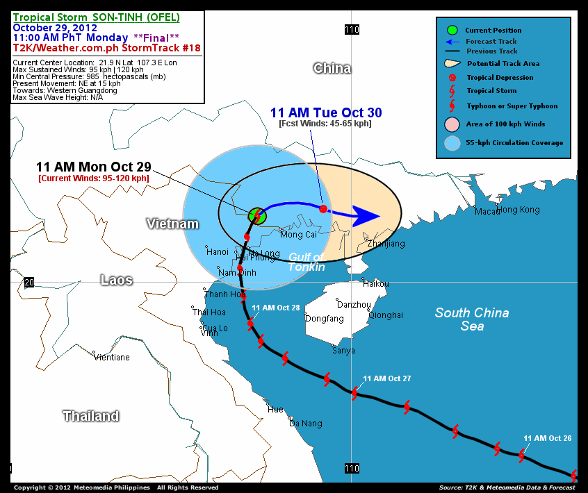
As of 11 am today, the center of Tropical Storm Son-Tinh (Ofel) was located over the southern part of Guangxi Province, China...about 76 km west-northwest of Mong Cai, Vietnam or 105 km north-northeast of Ha Long, Vietnam...currently moving northeast with a forward speed of 15 km/hr in the general direction of Southern Guangxi and Western Guangdong.
Maximum Sustained Winds (1-min. avg) have rapidly decreased to 95 km/hr near the center with higher gusts. . Son-Tinh (Ofel) is an average-sized tropical cyclone with a diameter of 445 kilometers across. The 24-hour rainfall accumulation near the center of Son-Tinh (Ofel) is estimated to be heavy (350 mm).
1-DAY FORECAST OUTLOOK*
Tropical Storm Son-Tinh (Ofel) is expected to move slowly east-northeast to eastward during the next 24 hours. On the forecast track, the core of Son-Tinh (Ofel) is expected to move over the western part of Guangdong Province on Tuesday.
This storm will continue to lose strength, weakening into a Tropical Depression later tonight until Tuesday morning...and Son-Tinh (Ofel) will dissipate into an area of low pressure on Tuesday afternoon.
The following is the summary of the 1-day forecast outlook on this system:
 TUESDAY MORNING: Over Southwestern China...just a Tropical Depression dissipating over land...about 150 km east-northeast of Mong Cai, Vietnam [11AM OCT 30: 22.1N 109.2E @ 45kph].
*Please be reminded that the Forecast Outlook changes every 6 hours, and the Day 3 Forecast Track have an average error of 250 km...while the wind speed forecast error, averages 35 kph per day. Therefore, a turn to the left or right of its future track and changes in its wind speed must be anticipated from time to time.
EFFECTS & HAZARDS SUMMARY
Below is the summary of the storm's parts and its hazards affecting specific areas. You can also view this image link for you to understand the parts.
INNER RAINBANDS - affecting and spreading across the Northeastern portion of Northern Vietnam and southern portion of Guangxi Province. Tropical Storm Conditions with Tropical Storm Force Winds (62-117 kph) will be expected along these bands. OUTER RAINBANDS - affecting and spreading across the northern part of Hainan Island, the northern part of the Gulf of Tonkin, and Southwestern China. Tropical Depression Conditions with moderate to strong winds (<62 kph) will be expected along these bands (click here to know more about Rainbands). 24HR TOTAL RAINFALL ACCUMULATION - from 5 up to 200 mm (light to heavy rainfall) can be expected along areas affected by the outer & inner rainbands (see above)...with isolated amounts of 201 to 350 mm (heavy) along areas near the center of Son-Tinh (Ofel).
Important Note: Please keep in mind that the above forecast outlook, effects and hazards summary changes every 6 to 12 hrs!
CURRENT TECHNICAL INFORMATION
Time/Date: 11:00 AM PhT Mon October 29, 2012
Class/Name: TS Son-Tinh (Ofel)
Location of Center: 21.9� N Lat 107.3� E Lon
Distance 1: 76 km (WNW) closer to Mong Cai, Vietnam
Distance 2: 105 km (NNE) away from Ha Long, Vietnam
Distance 3: 127 km (NE) away from Hai Phong, Vietnam
Distance 4: 185 km (ENE) away from Hanoi, Vietnam
Distance 5: 327 km (WNW) closer to Zhanjiang, China
MaxWinds (1-min avg): 95 kph near the center
Peak Wind Gusts: 120 kph
Present Movement: NE @ 15 kph
Towards: Southern Guangxi-Western Guangdong Area
24hr Rainfall Accum (near center): Heavy [350 mm]
Minimum Central Pressure: 985 millibars (hPa)
Size (in Diameter): 445 km [Large]
Max Sea Wave Height (near center): XX feet
Possible Storm Surge Height: 1-3 ft (0.3-0.9 m)
T2K Final StormTracks (for Public): GIF | Google Map (Flash)

CURRENT NOAA/MTSAT-2 INFRARED SATELLITE IMAGE:

CURRENT TRACKING CHART:
_____________________________________________________________________________
>> To know the meteorological terminologies and acronyms used on this update visit the ff:
http://typhoon2000.ph/tcterm.htm
http://www.nhc.noaa.gov/aboutgloss.shtml
http://www.nhc.noaa.gov/acronyms.shtml
__________________________________________________________________________________________
For the complete details on TS SON-TINH (OFEL)...go visit our website @:
> http://www.typhoon2000.com
> http://www.maybagyo.com
<<<Typhoon2000.com Mobile >>>
Get the latest SMS Storm Alerts!
For more details: Text T2K TYPHOON to
2800 (Globe/TM) | 216 (Smart/TNT) | 2288 (Sun)
*Only P2.50 (Smart/Globe) / P2.00 (Sun) per msg received.
Click here on how to use this service (in PDF file)
Powered by: Synermaxx Corporation
Copyright © 2012 Typhoon2000.com All Rights Reserved
| Reply via web post | Reply to sender | Reply to group | Start a New Topic | Messages in this topic (1) |

No comments:
Post a Comment