
WEATHER.COM.PH / T2K TROPICAL CYCLONE UPDATES
TYPHOON PRAPIROON (NINA) UPDATE NUMBER 017
Issued: 12:00 NN PhT (04:00 GMT) Saturday 13 Oct 2012
Next Update: 6:00 PM PhT (10:00 GMT) Saturday 13 Oct 2012
Typhoon PRAPIROON (NINA) creeping northeastward across the North Philippine Sea...continues to weaken. Outer rainbands now spreading across Okinawa and the Ryukyu Islands.
Residents and visitors along Okinawa and Southern Japan should closely monitor the development of Prapiroon (Nina).
Do not use this for life or death decision. This update is intended for additional information purposes only. Kindly refer to your national weather agency for official warnings, advisories or bulletins.
CURRENT STORM ANALYSIS
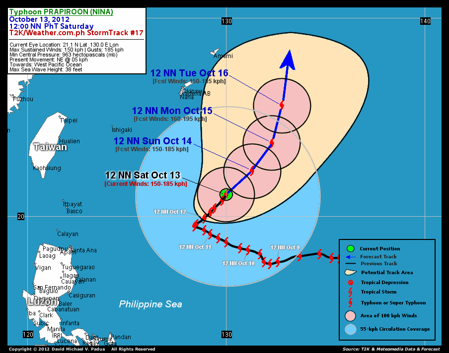
As of 12 noon today, the eye of Typhoon Prapiroon (Nina) was located over the open waters of the North Philippine Sea...about 835 km east-northeast of Basco, Batanes or 641 km south-southeast of Okinawa City, Japan...currently moving northeast slowly with a forward speed of 5 km/hr.
Maximum Sustained Winds (1-min. avg) have decreased to 150 km/hr near the center with higher gusts. Typhoon Force Winds (118 km/hr or more) extend outward up to 75 kilometers (40 nautical miles) from the center...and Tropical Storm Force Winds (62-117 km/hr) extend outward up to 350 kilometers. These winds will remain over the open sea, not affecting any land areas. Prapiroon (Nina) is a very large-sized tropical cyclone with a diameter of 1,000 kilometers across. The 24-hour rainfall accumulation near and south of the center of Prapiroon (Nina) is estimated to be heavy (400 mm).
3-DAY FORECAST OUTLOOK*
Prapiroon (Nina) is expected to continue moving slowly northeast to north-northeastward during the next 24 hours...and this movement will continue throughout the forecast period. On the forecast track, the core of Prapiroon (Nina) will continue to remain over the open sea...and may exit the Philippine Area of Responsibility (PAR) on Tuesday.
This typhoon may still gain a little bit of strength during the next 24 hours before it weakens. This weakening trend of Prapiroon (Nina) in the next couple of days is due to its movement across cooler sea surface temperatures (lower heat content) and unfavorable atmospheric conditions.
The following is the summary of the 3-day forecast outlook on this system:
 SUNDAY NOON: Moving slowly northeastward as it maintains its category 1 strength...about 586 km southeast of Okinawa, Japan [12PM OCT 14: 22.3N 131.3E @ 150kph].
MONDAY NOON: Regains category 2 strength while moving away from the North Philippine Sea...about 550 km southeast of Okinawa, Japan [12PM OCT 15: 23.7N 132.3E @ 160kph].
TUESDAY NOON: Exits the PAR as it nears Okinawa and the Ryukyu Islands...about 509 east-southeast of Okinawa, Japan [12PM OCT 16: 25.6N 132.8E @ 150kph].
*Please be reminded that the Forecast Outlook changes every 6 hours, and the Day 3 Forecast Track have an average error of 250 km...while the wind speed forecast error, averages 35 kph per day. Therefore, a turn to the left or right of its future track and changes in its wind speed must be anticipated from time to time.
EFFECTS & HAZARDS SUMMARY
Below is the summary of the storm's parts and its hazards affecting specific areas. You can also view this image link for you to understand the parts.
EYE - over water (North Philippine Sea)...not affecting any land areas. Possible calm and lull conditions (with <20 kph winds) will be expected inside the eye (click here to know more about the EYE). EYEWALL - over water (North Philippine Sea)...not affecting any land areas. Typhoon Conditions with Typhoon Force Winds (>118 kph) will be expected within this wall (click here to know more about the Eyewall). INNER RAINBANDS - over water (North Philippine Sea)...not affecting any land areas. Tropical Storm Conditions with Tropical Storm Force Winds (62-117 kph) will be expected along these bands. OUTER RAINBANDS - affecting and spreading across Okinawa and Ryukyu Islands. Tropical Depression Conditions with moderate to strong winds (<62 kph) will be expected along these bands (click here to know more about Rainbands). 24HR TOTAL RAINFALL ACCUMULATION - from 5 up to 200 mm (low to heavy rainfall) can be expected along areas affected by the outer & inner rainbands (see above)...with isolated amounts of 201 to 400 mm (heavy) along areas near the center of Prapiroon (Nina).
Important Note: Please keep in mind that the above forecast outlook, effects and hazards summary changes every 6 to 12 hrs!
CURRENT TECHNICAL INFORMATION
Time/Date: 12:00 NN PhT Sat October 13, 2012
Class/Name: Typhoon Prapiroon (Nina)
Location of Eye: 21.1º N Lat 130.0º E Lon
Distance 1: 613 km (SSE) closer to Naha Airport, Okinawa
Distance 2: 630 km (SSE) closer to Kadena Air Base, Okinawa
Distance 3: 641 km (SSE) closer to Okinawa City
Distance 4: 803 km (S) closer to Amami Is., Ryukyus
Distance 5: 835 km (ENE) away from Basco, Batanes
MaxWinds (1-min avg): 150 kph near the center
Peak Wind Gusts: 185 kph
Present Movement: NE @ 05 kph
Towards: Western Pacific Ocean
24hr Rainfall Accum (near center): Heavy [400 mm]
Minimum Central Pressure: 963 millibars (hPa)
Size (in Diameter): 1,000 km [Very Large]
Max Sea Wave Height (near center): 38 feet
Possible Storm Surge Height: 4-5 ft (1.2-1.7 m)
T2K StormTracks (for Public): GIF | Google Map (Flash)

CURRENT NOAA/MTSAT-2 INFRARED SATELLITE IMAGE:

CURRENT TRACKING CHART:
_____________________________________________________________________________
>> To know the meteorological terminologies and acronyms used on this update visit the ff:
http://typhoon2000.ph/tcterm.htm
http://www.nhc.noaa.gov/aboutgloss.shtml
http://www.nhc.noaa.gov/acronyms.shtml
__________________________________________________________________________________________
For the complete details on TY PRAPIROON (NINA)...go visit our website @:
> http://www.typhoon2000.com
> http://www.maybagyo.com
<<<Typhoon2000.com Mobile >>>
Get the latest SMS Storm Alerts!
For more details: Text T2K TYPHOON to
2800 (Globe/TM) | 216 (Smart/TNT) | 2288 (Sun)
*Only P2.50 (Smart/Globe) / P2.00 (Sun) per msg received.
Click here on how to use this service (in PDF file)
Powered by: Synermaxx Corporation
Copyright © 2012 Typhoon2000.com All Rights Reserved
| Reply via web post | Reply to sender | Reply to group | Start a New Topic | Messages in this topic (1) |

No comments:
Post a Comment