
WEATHER.COM.PH / T2K TROPICAL CYCLONE UPDATES
TROPICAL STORM PRAPIROON (NINA) UPDATE NUMBER 032 [FINAL]
Issued: 1:00 PM PhT (23:00 GMT) Friday 19 Oct 2012
Tropical Storm Prapiroon (Nina) weakens while moving rapidly across the open sea of the Western Pacific Ocean. Outer rainbands has started to recede away from the coastal areas of Southeastern Japan.
This is the last and final update on Prapiroon (Nina).
Do not use this for life or death decision. This update is intended for additional information purposes only. Kindly refer to your national weather agency for official warnings, advisories or bulletins.
CURRENT STORM ANALYSIS
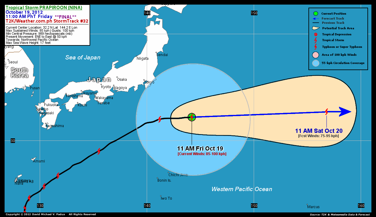
As of 11 am today, the center of Tropical Storm Prapiroon (Nina) was located over the open waters of the Sea southeast of Japan...about 561 km southeast of Tokyo, Japan or 1,712 km east-northeast of Okinawa, Japan...currently moving rapidly to the east with a forward speed of 50 km/hr.
Maximum Sustained Winds (1-min. avg) have decreased to 95 km/hr near the center with higher gusts. Tropical Storm Force Winds (62-117 km/hr) extend outward up to 290 kilometers from the center. Improving weather conditions will be expected later tonight across Ryukyus as the storm continues to move away. Prapiroon (Nina) is a very large-sized tropical cyclone with a diameter of 1,000 kilometers across. The 24-hour rainfall accumulation near the center of Prapiroon (Nina) is estimated to be heavy (200 mm).
1-DAY FORECAST OUTLOOK*
Tropical Storm Prapiroon (Nina) is expected to continue moving rapidly eastward during the next 24 hours. On the forecast track, the core of Prapiroon (Nina) will continue to move across the open sea of the Western Pacific today and Saturday.
This storm will continue to weaken during the next 24 hours...and Prapiroon (Nina) will become an Extratropical Cyclone later tonight or Saturday.
The following is the summary of the 1-day forecast outlook on this system:
 SATURDAY MORNING: Completed its Extratropical transition as it tracks eastward...about 1,593 km east-southeast of Tokyo, Japan [11AM OCT 20: 33.4N 156.9E @ 75kph].
*Please be reminded that the Forecast Outlook changes every 6 hours, and the Day 3 Forecast Track have an average error of 250 km...while the wind speed forecast error, averages 35 kph per day. Therefore, a turn to the left or right of its future track and changes in its wind speed must be anticipated from time to time.
EFFECTS & HAZARDS SUMMARY
Below is the summary of the storm's parts and its hazards affecting specific areas. You can also view this image link for you to understand the parts.
INNER RAINBANDS - over water (Sea south of Japan). Tropical Storm Conditions with Tropical Storm Force Winds (62-117 kph) will be expected along these bands. OUTER RAINBANDS - affecting and spreading across Eastern Honshu. Tropical Depression Conditions with moderate to strong winds (<62 kph) will be expected along these bands (click here to know more about Rainbands). 24HR TOTAL RAINFALL ACCUMULATION - from 5 up to 100 mm (light to heavy rainfall) can be expected along areas affected by the outer & inner rainbands (see above)...with isolated amounts of 101 to 200 mm (heavy) along areas near the center of Prapiroon (Nina).
Important Note: Please keep in mind that the above forecast outlook, effects and hazards summary changes every 6 to 12 hrs!
CURRENT TECHNICAL INFORMATION
Time/Date: 11:00 AM PhT Fri October 19, 2012
Class/Name: TS Prapiroon (Nina)
Location of Center: 32.2º N Lat 144.2º E Lon
Distance 1: 561 km (SE) away from Tokyo, Japan
Distance 2: 626 km (NNE) away from Chichi Jima
Distance 3: 1,712 km (ENE) away from Okinawa, Japan
MaxWinds (1-min avg): 85 kph near the center
Peak Wind Gusts: 100 kph
Present Movement: East @ 50 kph
Towards: NW Pacific Ocean
24hr Rainfall Accum (near center): Heavy [200 mm]
Minimum Central Pressure: 989 millibars (hPa)
Size (in Diameter): 1,000 km [Very Large]
Max Sea Wave Height (near center): 17 feet
Possible Storm Surge Height: 1-3 ft (0.3-0.9 m)
T2K StormTracks (for Public): GIF | Google Map (Flash)

CURRENT NOAA/MTSAT-2 INFRARED SATELLITE IMAGE:

CURRENT TRACKING CHART:
_____________________________________________________________________________
>> To know the meteorological terminologies and acronyms used on this update visit the ff:
http://typhoon2000.ph/tcterm.htm
http://www.nhc.noaa.gov/aboutgloss.shtml
http://www.nhc.noaa.gov/acronyms.shtml
__________________________________________________________________________________________
For the complete details on TS PRAPIROON (NINA)...go visit our website @:
> http://www.typhoon2000.com
> http://www.maybagyo.com
<<<Typhoon2000.com Mobile >>>
Get the latest SMS Storm Alerts!
For more details: Text T2K TYPHOON to
2800 (Globe/TM) | 216 (Smart/TNT) | 2288 (Sun)
*Only P2.50 (Smart/Globe) / P2.00 (Sun) per msg received.
Click here on how to use this service (in PDF file)
Powered by: Synermaxx Corporation
Copyright © 2012 Typhoon2000.com All Rights Reserved
| Reply via web post | Reply to sender | Reply to group | Start a New Topic | Messages in this topic (1) |

No comments:
Post a Comment