
WEATHER.COM.PH / T2K TROPICAL CYCLONE UPDATES
TROPICAL DEPRESSION SON-TINH (OFEL) UPDATE NUMBER 001
Issued: 7:00 AM PhT (23:00 GMT) Wednesday 24 Oct 2012
Next Update: 1:00 PM PhT (05:00 GMT) Wednesday 24 Oct 2012
The strong disturbance near the coast of Surigao Del Sur has strengthened into a Tropical Depression named Son-Tinh (Ofel)...now threatening Northern Mindanao and Visayas. Its rainbands now spreading across the area. Son-Tinh is a Vietnamese name for their mythical God of Mountain.
Meanwhile, this system will continue to enhance the Northeast Monsoon (Amihan) and bring on-and-off rains, squalls, thunderstorms across the Bicol Region and Northern Visayas including some parts of Quezon. Winds will be moderate to strong not in excess of 50 km/hr. The sea waves along the coast will be rough and dangerous (8-11 feet).
Residents and visitors along Northern Mindanao, Visayas and Bicol Region should closely monitor the development of Son-Tinh (Ofel).
Do not use this for life or death decision. This update is intended for additional information purposes only. Kindly refer to your national weather agency for official warnings, advisories or bulletins.
CURRENT STORM ANALYSIS
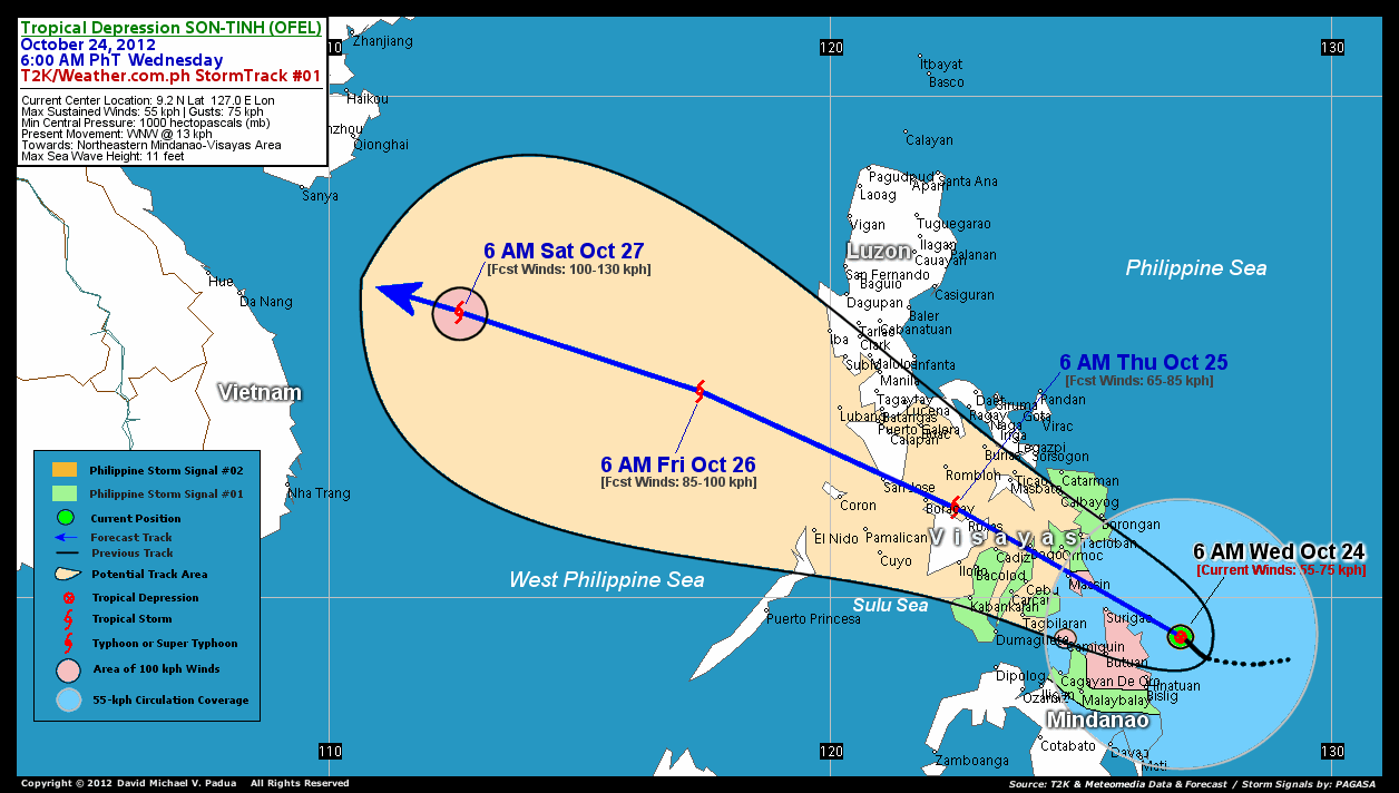
As of 6 am today, the center of Tropical Depression Son-Tinh (Ofel) was located near the east coast of Surigao De Norte...about 167 km east-southeast of Siargao Island or 177 km east-southeast of Surigao City...currently moving west-northwest with a forward speed of 13 km/hr in the general direction of Surigao Del Norte and Leyte Area.
Maximum Sustained Winds (1-min. avg) are at 55 km/hr near the center with higher gusts. Son-Tinh (Ofel) is an average-sized tropical cyclone with a diameter of 555 kilometers across. The 24-hour rainfall accumulation near the center of Son-Tinh (Ofel) is estimated to be extreme (400 mm).
3-DAY FORECAST OUTLOOK*
Tropical Depression Son-Tinh (Ofel) is expected to accelerate west-northwestward during the next 24 hours and will continue to maintain this track through the next 3 days. On the forecast track, the core of Son-Tinh (Ofel) is expected make landfall over Southern Leyte early tonight and pass very close to Maasin City...and could traverse the northern part of Cebu (near Bogo City) late tonight. By Thursday, Son-Tinh (Ofel) may be in the vicinity of Northern Coast of Panay, passing very close to Roxas City and Boracay Island Resort during the morning and should be crossing the Southern tip of Mindoro, passing very close San Jose in the afternoon. On Friday and Saturday, Son-Tinh (Ofel) shall be moving into the West Philippine Sea-South China Sea area, well outside of the Philippine Area of Responsibility (PAR).
This depression is expected to slowly intensify as it moves across the Visayas during the next 12 to 24 hours...and Son-Tinh (Ofel) could become a Tropical Storm today.
The following is the summary of the 3-day forecast outlook on this system:
 THURSDAY MORNING: Traversing Central Visayas as it becomes a minimal Tropical Storm...just along the Northern Coast of Panay Island...about 66 km east-southeast of Boracay Island Resort [6AM OCT 25: 11.8N 122.5E @ 65kph].
FRIDAY MORNING: Becoming a strong Tropical Storn as it moves faster across the West Philippine Sea...about 390 km west-southwest of Manila [6AM OCT 26: 14.1N 117.4E @ 85kph].
SATURDAY MORNING: Exits the Philippine Area of Responsibility (PAR)...approaching the east coast of Vietnam...about 473 east-southeast of Da Nang, Vietnam [6AM OCT 27: 15.7N 112.6E @ 100kph].
*Please be reminded that the Forecast Outlook changes every 6 hours, and the Day 3 Forecast Track have an average error of 250 km...while the wind speed forecast error, averages 35 kph per day. Therefore, a turn to the left or right of its future track and changes in its wind speed must be anticipated from time to time.
EFFECTS & HAZARDS SUMMARY
Below is the summary of the storm's parts and its hazards affecting specific areas. You can also view this image link for you to understand the parts.
INNER RAINBANDS - affecting and spreading across Siargao and Dinagat Islands and the Coastal Areas of Surigao Provinces. Near-Tropical Storm Conditions with Near-Tropical Storm Force Winds (62-75 kph) will be expected along these bands. OUTER RAINBANDS - affecting and spreading across Northern Mindanao particularly the rest of CARAGA, Leyte and Samar Provinces. Tropical Depression Conditions with moderate to strong winds (<62 kph) will be expected along these bands (click here to know more about Rainbands). 24HR TOTAL RAINFALL ACCUMULATION - from 5 up to 200 mm (light to heavy rainfall) can be expected along areas affected by the outer & inner rainbands (see above)...with isolated amounts of 201 to 400 mm (heavy to extreme) along areas near and north of the center of Son-Tinh (Ofel).
Important Note: Please keep in mind that the above forecast outlook, effects and hazards summary changes every 6 to 12 hrs!
CURRENT TECHNICAL INFORMATION
Time/Date: 6:00 AM PhT Wed October 24, 2012
Class/Name: TD Son-Tinh (Ofel)
Location of Center: 9.2º N Lat 127.0º E Lon
Distance 1: 167 km (ESE) closer to Siargao Is.
Distance 2: 177 km (ESE) closer to Surigao City
Distance 3: 135 km (NNE) away from Bislig City
Distance 4: 168 km (ENE) closer to Butuan City
Distance 5: 275 km (SE) closer to Maasin City
Distance 6: 312 km (SE) closer to Tacloban City
Distance 7: 354 km (ESE) closer to Tagbilaran City
Distance 8: 252 km (E) closer to Camiguin Is.
Distance 9: 330 km (SE) closer to Ormoc City
Distance 10: 361 km (ESE) closer to Metro Cebu
MaxWinds (1-min avg): 55 kph near the center
Peak Wind Gusts: 75 kph
Present Movement: WNW @ 13 kph
Towards: Surigao-Leyte Area
24hr Rainfall Accum (near center): Extreme [400 mm]
Minimum Central Pressure: 1000 millibars (hPa)
Size (in Diameter): 555 km [Average]
Max Sea Wave Height (near center): 11 feet
Possible Storm Surge Height: 1-3 ft (0.3-0.9 m)
T2K StormTracks (for Public): GIF | Google Map (Flash)

CURRENT NOAA/MTSAT-2 INFRARED SATELLITE IMAGE:

CURRENT TRACKING CHART:
_____________________________________________________________________________
>> To know the meteorological terminologies and acronyms used on this update visit the ff:
http://typhoon2000.ph/tcterm.htm
http://www.nhc.noaa.gov/aboutgloss.shtml
http://www.nhc.noaa.gov/acronyms.shtml
__________________________________________________________________________________________
For the complete details on TD SON-TINH (OFEL)...go visit our website @:
> http://www.typhoon2000.com
> http://www.maybagyo.com
<<<Typhoon2000.com Mobile >>>
Get the latest SMS Storm Alerts!
For more details: Text T2K TYPHOON to
2800 (Globe/TM) | 216 (Smart/TNT) | 2288 (Sun)
*Only P2.50 (Smart/Globe) / P2.00 (Sun) per msg received.
Click here on how to use this service (in PDF file)
Powered by: Synermaxx Corporation
Copyright © 2012 Typhoon2000.com All Rights Reserved
| Reply via web post | Reply to sender | Reply to group | Start a New Topic | Messages in this topic (1) |

No comments:
Post a Comment