
WEATHER.COM.PH / T2K TROPICAL CYCLONE UPDATES
TROPICAL STORM SON-TINH (OFEL) UPDATE NUMBER 009
Issued: 1:00 PM PhT (05:00 GMT) Friday 26 Oct 2012
Next Update: 6:00 PM PhT (10:00 GMT) Friday 26 Oct 2012
Tropical Storm Son-Tinh (Ofel) has gained strength as it moved out of the Philippine Area of Responsibility (PAR)...accelerating west-northwest towards Northern Vietnam.
Meanwhile, this system will continue to enhance the Northeast Monsoon (Amihan) and bring on-and-off rains, squalls, thunderstorms across Extreme Northern and Eastern Luzon. Winds will be moderate to strong not in excess of 40 km/hr. The sea waves along the coast will be rough and dangerous (8-12 feet).
Residents and visitors along Central and Northern Vietnam including Hainan Island should closely monitor the development of Son-Tinh (Ofel).
Do not use this for life or death decision. This update is intended for additional information purposes only. Kindly refer to your national weather agency for official warnings, advisories or bulletins.
CURRENT STORM ANALYSIS
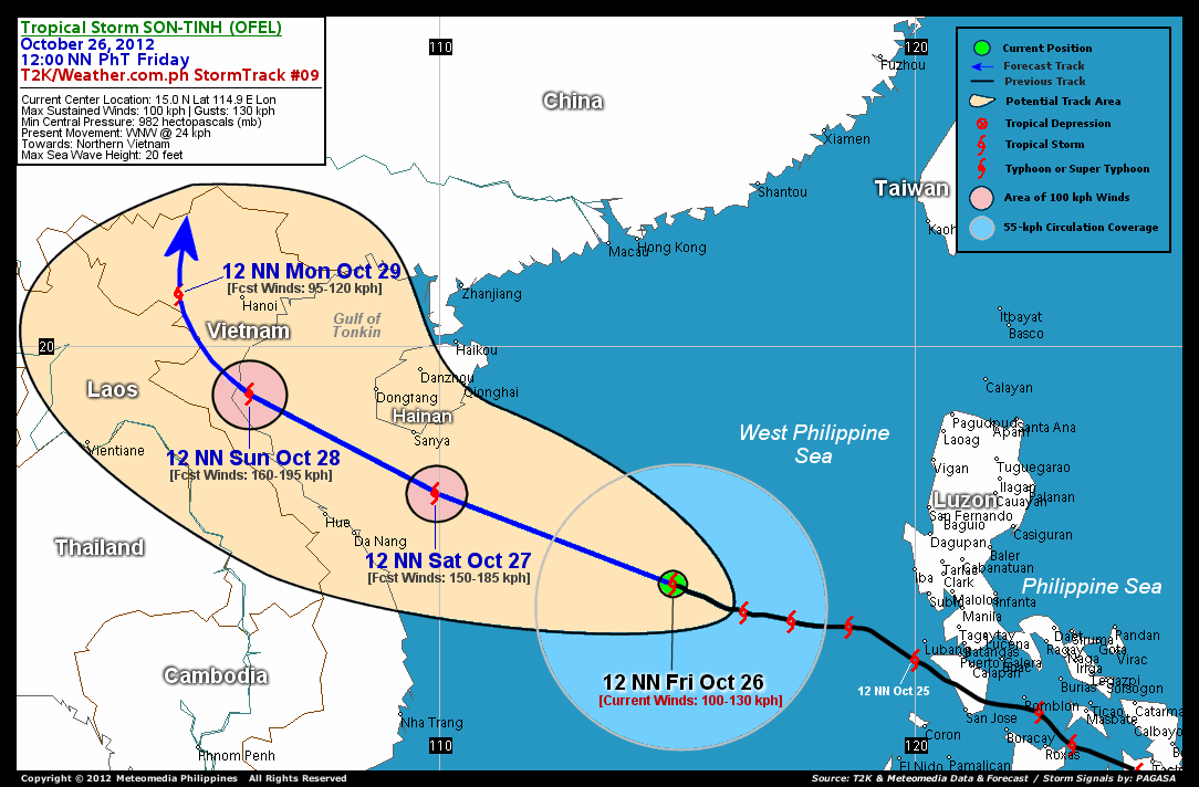
As of 12 noon today, the center of Tropical Storm Son-Tinh (Ofel) was located over the western boundary of the Philippine Area of Responsibility (PAR) off the West Philippine Sea...about 668 km west-northwest of Metro Manila or 676 km southeast of Sanya, Hainan Island...currently moving west-northwest with a forward speed of 24 km/hr in the general direction of Northern Vietnam.
Maximum Sustained Winds (1-min. avg) have increased to 100 km/hr near the center with higher gusts. Tropical Storm Force Winds (62-100 km/hr) extend outward up to 120 kilometers from the center. Son-Tinh (Ofel) is an average-sized tropical cyclone with a diameter of 665 kilometers across. The 24-hour rainfall accumulation near the center of Son-Tinh (Ofel) is estimated to be heavy (220 mm).
3-DAY FORECAST OUTLOOK*
Tropical Storm Son-Tinh (Ofel) is expected to continue moving west-northwestward during the next 12 to 24 hours with an increase in its forward speed. It will therefore maintain its track through 48 hours. Between 48 to 72 hours, Son-Tinh (Ofel) may start turning northwestward. On the forecast track, the core of Son-Tinh (Ofel) is expected to continue moving across the South China Sea today until Saturday. The storm should then be passing south of Hainan Island Saturday evening and approach the coast of Northern Vietnam Sunday morning. Son-Tinh (Ofel) is forecast to make landfall along the shores of Northern Vietnam on Sunday afternoon and move over land into the northernmost part of Vietnam Monday afternoon.
This storm is expected to rapidly intensify during the next 2 days, while over the South China Seas...and Son-Tinh (Ofel) could become a Typhoon tonight.
The following is the summary of the 3-day forecast outlook on this system:
 SATURDAY NOON: Passing to the south of Hainan Island...intensifies into a well-developed Typhoon...about 151 km south-southeast of Sanya, Hainan Island [12PM OCT 27: 16.9N 109.9E @ 150kph].
SUNDAY NOON: Becomes a Category 2 Typhoon as it prepares to make landfall over Northern Vietnam...about 223 km south-southeast of Hanoi, Vietnam [12PM OCT 28: 19.0N 106.0E @ 160kph].
MONDAY NOON: Weakens into a Tropical Storm as it dissipates over land...in the vicinity of Northern Vietnam...about 135 km west of Hanoi [12PM OCT 29: 21.1N 104.5E @ 95kph].
*Please be reminded that the Forecast Outlook changes every 6 hours, and the Day 3 Forecast Track have an average error of 250 km...while the wind speed forecast error, averages 35 kph per day. Therefore, a turn to the left or right of its future track and changes in its wind speed must be anticipated from time to time.
EFFECTS & HAZARDS SUMMARY
Below is the summary of the storm's parts and its hazards affecting specific areas. You can also view this image link for you to understand the parts.
INNER RAINBANDS - over water (West Philippine Sea)...not affecting any land areas. Tropical Storm Conditions with Tropical Storm Force Winds (62-85 kph) will be expected along these bands. OUTER RAINBANDS - affecting and spreading across Western Coast of Luzon. Tropical Depression Conditions with moderate to strong winds (<62 kph) will be expected along these bands (click here to know more about Rainbands). 24HR TOTAL RAINFALL ACCUMULATION - from 5 up to 100 mm (light to heavy rainfall) can be expected along areas affected by the outer & inner rainbands (see above)...with isolated amounts of 101 to 220 mm (heavy) along areas near the center of Son-Tinh (Ofel).
Important Note: Please keep in mind that the above forecast outlook, effects and hazards summary changes every 6 to 12 hrs!
CURRENT TECHNICAL INFORMATION
Time/Date: 12:00 NN PhT Fri October 26, 2012
Class/Name: TS Son-Tinh (Ofel)
Location of Center: 15.0� N Lat 114.9� E Lon
Distance 1: 548 km (W) away from Iba, Zambales
Distance 2: 581 km (WNW) away from Subic Bay
Distance 3: 589 km (WSW) away from Dagupan City
Distance 4: 668 km (WNW) away from Metro Manila
Distance 5: 676 km (SE) closer to Sanya, Hainan
Distance 6: 728 km (ESE) closer to Da Nang, Vietnam
Distance 7: 799 km (ESE) closer to Hue, Vietnam
Distance 8: 801 km (SE) closer to Dongfang, Hainan
Distance 9: 1,162 km (NE) closer to Hanoi, Vietnam
MaxWinds (1-min avg): 100 kph near the center
Peak Wind Gusts: 130 kph
Present Movement: WNW @ 24 kph
Towards: Northern Vietnam
24hr Rainfall Accum (near center): Heavy [220 mm]
Minimum Central Pressure: 982 millibars (hPa)
Size (in Diameter): 665 km [Average]
Max Sea Wave Height (near center): 20 feet
Possible Storm Surge Height: 1-3 ft (0.3-0.9 m)
T2K StormTracks (for Public): GIF | Google Map (Flash)

CURRENT NOAA/MTSAT-2 INFRARED SATELLITE IMAGE:

CURRENT TRACKING CHART:
_____________________________________________________________________________
>> To know the meteorological terminologies and acronyms used on this update visit the ff:
http://typhoon2000.ph/tcterm.htm
http://www.nhc.noaa.gov/aboutgloss.shtml
http://www.nhc.noaa.gov/acronyms.shtml
__________________________________________________________________________________________
For the complete details on TS SON-TINH (OFEL)...go visit our website @:
> http://www.typhoon2000.com
> http://www.maybagyo.com
<<<Typhoon2000.com Mobile >>>
Get the latest SMS Storm Alerts!
For more details: Text T2K TYPHOON to
2800 (Globe/TM) | 216 (Smart/TNT) | 2288 (Sun)
*Only P2.50 (Smart/Globe) / P2.00 (Sun) per msg received.
Click here on how to use this service (in PDF file)
Powered by: Synermaxx Corporation
Copyright © 2012 Typhoon2000.com All Rights Reserved
| Reply via web post | Reply to sender | Reply to group | Start a New Topic | Messages in this topic (1) |

No comments:
Post a Comment