
WEATHER.COM.PH / T2K TROPICAL CYCLONE UPDATES
TROPICAL STORM GAEMI (MARCE) UPDATE NUMBER 014
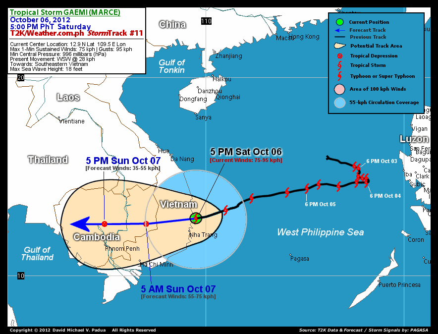
Issued: 5:00 PM PhT (09:00 GMT) Sat 06 October 2012
Next Update: 5:00 AM PhT (21:00 GMT) Sun 07 October 2012
Tropical Storm GAEMI (MARCE) just along the shores of Southeastern Vietnam...starts to make landfall just north of Nha Trang City. Tropical Storm Conditions occurring across the area.
Residents and visitors along Vietnam and Cambodia should closely monitor the development of Gaemi (Marce).
Do not use this for life or death decision. This update is intended for additional information purposes only. Kindly refer to your national weather agency for official warnings, advisories or bulletins.
CURRENT STORM ANALYSIS
As of 5 am today, the center of Tropical Storm Gaemi (Marce) was located off the shores of Ninh Hoa...about 74 km north-northeast of Nha Trang, Vietnam and is currently moving west-southwestward with a forward speed of 28 kph in the general direction of Southern Vietnam and Cambodia.
Maximum Sustained Winds (1-min. avg) remain at 75 km/hr near the center with higher gusts. Tropical Storm Force Winds (62-117 km/hr) extend outward up to 120 kilometers from the center. These winds are now occurring along the shores of Southeastern Vietnam (from Qui Nhon down to Cam Ranh Bay) and is likely to persist until tonight. Gaemi (Marce) is an average-sized tropical cyclone with a diameter of 555 kilometers across. The 24-hour rainfall accumulation near the center of Gaeme (Marce) is estimated to be extreme (500 mm).
1-DAY FORECAST OUTLOOK*
Gaemi (Marce) is expected to continue moving west to west-southwestward throughout the forecast period, with a possible decrease in its forward speed. On the forecast track, the center of Gaemi (Marce) will be crossing Southeastern Vietnam tonight and is forecast to traverse the mountainous terrain of Cambodia throughout Sunday.
Rapid weakening of its wind speed is expected as the system moves over land, across Vietnam overnight. Gaemi (Marce) is likely to dissipate rapidly once it enters Cambodia on Sunday.
The following is the summary of the 1-day forecast outlook on this system:
 SUNDAY AFTERNOON: Dissipating along the central part of Cambodia...just a Tropical Disturbance (LPA)...about 111 km north of Phnom Penh, Cambodia [5PM OCT 07: 12.6N 104.9E @ 35kph].
*Please be reminded that the Forecast Outlook changes every 6 hours, and the Day 3 Forecast Track have an average error of 250 km...while the wind speed forecast error, averages 35 kph per day. Therefore, a turn to the left or right of its future track and changes in its wind speed must be anticipated from time to time.
EFFECTS & HAZARDS SUMMARY
Below is the summary of the storm's parts and its hazards affecting specific areas. You can also view this image link for you to understand the parts.
INNER RAINBANDS - affecting and spreading across the coastal areas of Southeastern Vietnam (from Qui Nhon down to Cam Ranh Bay). Tropical Storm Conditions with Tropical Storm Force Winds (62-117 kph) will be expected along these bands. OUTER RAINBANDS - affecting and spreading across Southern Vietnam and Eastern Cambodia. Cloudy/Rainy Conditions with moderate to strong winds (<62 kph) will be expected along these bands (click here to know more about Rainbands). 24HR TOTAL RAINFALL ACCUMULATION - from 5 up to 200 mm (low to heavy rainfall) can be expected along areas affected by the outer & inner rainbands (see above)...with isolated amounts of 201 to 500 mm (heavy to extreme) along areas near the center of Gaemi (Marce).
Important Note: Please keep in mind that the above forecast outlook, effects-hazards, current monsoon intensity, & tropical cyclone watch changes every 6 to 12 hrs!
CURRENT TECHNICAL INFORMATION
Time/Date: 5:00 PM PhT Sat October 06, 2012
Class/Name: Tropical Storm Gaemi (Marce)
Location of Center: 12.9º N Lat 109.5º E Lon
Distance 1: 74 km (NNE) closer to Nha Trang, Vietnam
Distance 2: 382 km (SSE) away from Da Nang, Vietnam
Distance 3: 384 km (NE) closer to Ho Chi Minh City
Distance 4: 449 km (SSE) away from Hue, Vietnam
Distance 5: 520 km (ENE) closer to Phnom Penh, Cambodia
Distance 6: 1267 km (WSW) away from Metro Manila
MaxWinds (1-min avg): 75 kph near the center
Peak Wind Gusts: 95 kph
Present Movement: WSW @ 28 kph
Towards: Southeastern Vietnam
24hr Rainfall Accum (near center): Extreme [500 mm]
Minimum Central Pressure: 993 millibars (hPa)
Size (in Diameter): 555 km (300 nm) [Average]
Max Sea Wave Height (near center): 18 ft
Possible Coastal Storm Surge Height: 1-3 ft (0.3-0.9 m)
T2K StormTracks (for Public): Google Map (Flash) | GIF

CURRENT NOAA/MTSAT-2 INFRARED (IR) SATELLITE IMAGE:

CURRENT TRACKING MAP:
 _____________________________________________________________________________
>> To know the meteorological terminologies and acronyms used on this update visit the ff:
http://typhoon2000.ph/tcterm.htm
http://www.nhc.noaa.gov/aboutgloss.shtml
http://www.nhc.noaa.gov/acronyms.shtml
__________________________________________________________________________________________
For the complete details on TS GAEMI (MARCE)...go visit our website @:
> http://www.typhoon2000.com
> http://www.maybagyo.com
<<<Typhoon2000.com Mobile >>>
Get the latest SMS Storm Alerts!
For more details: Text T2K TYPHOON to
2800 (Globe/TM) | 216 (Smart/TNT) | 2288 (Sun)
*Only P2.50 (Smart/Globe) / P2.00 (Sun) per msg received.
Click here on how to use this service (in PDF file)
Powered by: Synermaxx Corporation
Copyright © 2012 Typhoon2000.com All Rights Reserved
| Reply via web post | Reply to sender | Reply to group | Start a New Topic | Messages in this topic (1) |

No comments:
Post a Comment