Tuesday, October 31, 2006

Typhoon CIMARON (PAENG) stalls over the South China Sea...[Update #009]


Typhoon2000 STORM UPDATE #009
Name: TYPHOON CIMARON [PAENG/22W/0619] 
Issued: 7:00 AM MANILA TIME (23:00 GMT) TUE 31 OCTOBER 2006
Next Update: 7:00 PM (11:00 GMT) TUE 31 OCTOBER 2006
Source: JTWC TROPICAL CYCLONE WARNING #017
_______________________________________________________________________
 
 
TYPHOON CIMARON (PAENG) SLOWS DOWN ABRUPTLY OVER THE
SOUTH CHINA SEA
.

+ FORECAST OUTLOOK: CIMARON is expected to re-intensify
over the South China Sea and move on a West to WSW track
in the direction of Vietnam. The 3 to 5-day (Nov 3-5)
long-range forecast shows CIMARON weakening but making
its 2nd landfall along Vietnam as a downgraded Tropical
Storm by Saturday morning, Nov 4...and dissipating over
Laos Sunday Nov 5
. 

+ EFFECTS: The system's outer bands continues to affect
La Union, Zambales, Western Pangasinan & Ilocos Provin-
ces...however improving weather conditions can be expec-
ted later today as the typhoon slowly moves away. The
rest of Luzon is now free from the storm's circulation.
Coastal Storm Surge flooding of more than 2 to 5 feet
above normal tide levels...along with large and dange-
rous battering waves can be expected along the western
coast of Luzon today
.

Important Note: Please keep in mind that the above forecast
outlook, effects & current monsoon intensity, and tropical
cyclone watch changes every 06 to 12 hours!

_______________________________________________________________________

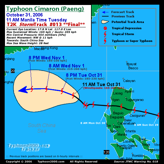
TIME/DATE: 5:00 AM MANILA TIME (21:00 GMT) 31 OCTOBER
LOCATION OF EYE: LATITUDE 17.1º N...LONGITUDE 117.7º E
DISTANCE 1: 290 KM (157 NM) WSW OF VIGAN CITY
DISTANCE 2: 315 KM (170 NM) WNW OF BAGUIO CITY
DISTANCE 3: 305 KM (165 NM) NW OF DAGUPAN CITY
DISTANCE 4: 460 KM (248 NM) NW OF METRO MANILA
MAX SUSTAINED WINDS [1-MIN AVG]: 165 KM/HR (90 KTS)
PEAK WIND GUSTS: 205 KM/HR (110 KTS)
SAFFIR-SIMPSON SCALE: CATEGORY TWO (2)
MINIMUM CENTRAL PRESSURE (est.): 954 MILLIBARS (hPa)
RECENT MOVEMENT: WNW @ 03 KM/HR (02 KTS)
GENERAL DIRECTION: SOUTH CHINA SEA
STORM'S SIZE (IN DIAMETER): 555 KM (300 NM)/AVERAGE
MAX WAVE HEIGHT**: 28 FEET (8.5 METERS)
VIEW TRACKING MAP: 5 AM PST TUE OCTOBER 31
TSR WIND PROBABILITIESCURRENT TO 120 HRS LEAD
  

PHILIPPINE STORM SIGNALS*:
#01 - LA UNION, PANGASINAN & ZAMBALES.
           
12, 24 & 48 HR. FORECAST:
2 PM (06 GMT) 31 OCT: 17.3N 116.9E / 185-230 KPH / W @ 13 KPH
2 AM (18 GMT) 01 NOV: 17.6N 115.4E / 215-260 KPH / W @ 13 KPH
2 AM (18 GMT) 02 NOV: 17.3N 112.7E / 165-205 KPH / W @ 11 KPH

REMARKS: 2 AM (18 GMT) 31 OCTOBER POSITION: 17.0N 118.0E.
^TY Cimaron has slowed over the last six hours as it has
reached its closest Point of approach to a weakness in the
subtropical ridge (str) located over Taiwan. TY Cimaron
will track westward under the influence of the section of
the str currently located over Hainan Island. This steering
str will shift steadily westward through 36 hours to a new
position over northern laos. From 48 hours, TY Cimaron will
track west-southwestward along the southeastern periphery
of the str..
.
(more info)

>> CIMARON {pronounced: see~mah~ron}, meaning: 
Philippine 
   Wild Ox
Name contributed by: Philippines
_______________________________________________________________________
_______________________________________________________________________

PAGASA CURRENT POSITION, MOVEMENT AND INTENSITY (10-min. ave.): 
> 4 AM (20 GMT) 31 OCTOBER: 16.7N 117.5E / WSW @ 13 KPH / 120 kph

:: For the complete PAGASA bulletin, kindly visit their website 
   at:
http://www.pagasa.dost.gov.ph/wb/tcupdate.shtml
_______________________________________________________________________

RECENT T2K TRACKING CHART:


_______________________________________________________________________________________

 
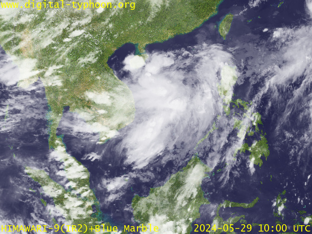
RECENT MTSAT-1R SATELLITE IMAGE:


> Image source:  Digital-Typhoon.org (Nat'l. Institute of Informatics) (http://www.digital-typhoon.org)
__________________________________________________________________________________________

NOTES:
 
  ^ - JTWC commentary remarks (for Meteorologists) from their 
      latest warning.
 
  * - Based on PAGASA's Philippine Storm Warning Signals, 
      # 4 being the highest. Red letters indicate new areas 
      being hoisted.
For more explanations on these signals, 
      visit:
http://www.typhoon2000.ph/signals.htm

 ** - Based on the Tropical Cyclone's Wave Height near 
      its center.

__________________________________________________________________________________________

>>
To know the meteorological terminologies and acronyms 
   used on this update visit the ff:

    http://typhoon2000.ph/tcterm.htm  
    http://www.nhc.noaa.gov/aboutgloss.shtml
    http://www.srh.noaa.gov/oun/severewx/glossary.php
    http://www.srh.weather.gov/fwd/glossarynation.html
    http://www.nhc.noaa.gov/acronyms.shtml
__________________________________________________________________________________________

:: Typhoon2000.com (T2K) Mobile >> Powered by: Synermaxx
Receive the latest storm updates directly to your mobile phones! To know more:
Send T2K HELP to: 2800
(GLOBE & TM) | 216 (SMART & TNT) | 2288 (SUN) 
Note: Globe & Smart charges P2.50 per message, while Sun at P2.00.
__________________________________________________________________________________________

For the complete details on TY CIMARON (PAENG)...go visit
our website @:

>
http://www.typhoon2000.com
http://www.maybagyo.com

:: Kindly view our site's disclaimer at: 
   
http://www.typhoon2000.ph/disclaimer.htm


__._,_.___
Recent Activity
Visit Your Group
SPONSORED LINKS
Get Low Fares

Yahoo! Travel

Flights, Hotels,

Cars, Cruises...

Make History

Make Your Mark

The Yahoo! Time

Capsule Project

Yahoo! Groups

Start a group

in 3 easy steps.

Connect with others.

.

__,_._,___

Monday, October 30, 2006

CIMARON (PAENG) becomes Super Typhoon, makes landfall...[Update #006]


Typhoon2000 STORM UPDATE #006
Name: SUPER TYPHOON CIMARON [PAENG/22W/0619] 
Issued: 7:00 PM MANILA TIME (11:00 GMT) SUN 29 OCTOBER 2006
Next Update: 7:00 AM (23:00 GMT) MON 30 OCTOBER 2006
Source: JTWC TROPICAL CYCLONE WARNING #012
_______________________________________________________________________
 
 
CIMARON (PAENG) BECOMES THE 6TH SUPER TYPHOON OF 2006
...TO MAKE LANDFALL ALONG ISABELA-NORTHERN AURORA TONIGHT
...TO CROSS NORTHERN LUZON OVERNIGHT TIL TOMORROW.

...CIMARON MAY BECOME THE MOST POWERFUL TYPHOON EVER
TO HIT NORTHERN LUZON SINCE SUPER TYPHOON ZEB (ILIANG)
OF OCTOBER 16, 1998.

+ FORECAST OUTLOOK: CIMARON is expected to cross Nor-
thern Luzon passing over the provinces of Aurora,
Northern Nueva Vizcaya, Ifugao, Northern Benguet,
and Ilocos Sur
. Advance forecast shows that Cimaron
will exit the South China Sea tomorrow afternoon and
move towards Vietnam. It shall strike Vietnam as a
weakened Tropical Storm sometime Nov 3, Friday. 

+ EFFECTS: The system's inner bands now affecting
Eastern Northern Luzon with the eye and eyewall
approaching Isabela-Northern Aurora. Typhoon conditions
can be expected across Northern Luzon overnight.
Coastal Storm Surge flooding of more than 18 feet
above normal tide levels...along with large and dange-
rous battering waves can be expected near and to the
north of where the center of Cimaron makes landfall in
Northern Luzon, Philippines tonight
.

Important Note: Please keep in mind that the above forecast
outlook, effects & current monsoon intensity, and tropical
cyclone watch changes every 06 to 12 hours!

_______________________________________________________________________

TIME/DATE: 5:00 PM MANILA TIME (09:00 GMT) 29 OCTOBER
LOCATION OF EYE: LATITUDE 16.4º N...LONGITUDE 123.0º E
DISTANCE 1: 100 KM (55 NM) ENE OF CASIGURAN, AURORA
DISTANCE 2: 310 KM (168 NM) NNW OF NAGA CITY
DISTANCE 3: 255 KM (138 NM) EAST OF BAGUIO CITY
MAX SUSTAINED WINDS [1-MIN AVG]: 260 KM/HR (140 KTS)
PEAK WIND GUSTS: 315 KM/HR (170 KTS)
SAFFIR-SIMPSON SCALE: CATEGORY FIVE (5)
MINIMUM CENTRAL PRESSURE (est.): 898 MILLIBARS (hPa)
RECENT MOVEMENT: WNW @ 19 KM/HR (10 KTS)
GENERAL DIRECTION: NORTHERN AURORA-ISABELA
STORM'S SIZE (IN DIAMETER): 590 KM (320 NM)/AVERAGE
MAX WAVE HEIGHT**: 33 FEET (10.0 METERS)
VIEW TRACKING MAP: 11 PM PST MON OCTOBER 30
TSR WIND PROBABILITIESCURRENT TO 120 HRS LEAD
  

PHILIPPINE STORM SIGNALS*:
#04 - ISABELA, SOUTHERN CAGAYAN, QUIRINO & NORTHERN AURORA.
#03 - REST OF AURORA, NUEVA VIZCAYA, IFUGAO, MT. PROVINCE, 
      PANGASINAN, BENGUET, LA UNION, ABRA, ILOCOS SUR, APAYAO, 
      KALINGA AND REST OF CAGAYAN.
#02 - CALAYAN ISLANDS, ILOCOS NORTE, NORTHERN ZAMBALES, TARLAC,
      NUEVA ECIJA, NORTHERN BULACAN, NORTHERN QUEZON, POLILLO
      ISLAND.
#01
- REST OF ZAMBALES, PAMPANGA, REST OF BULACAN, RIZAL, REST
      OF QUEZON AND CAMARINES NORTE.

           
12, 24 & 48 HR. FORECAST:
2 AM (18 GMT) 30 OCT: 16.8N 121.6E / 230-280 KPH / WNW @ 17 KPH
2 PM (06 GMT) 30 OCT: 17.3N 119.8E / 175-215 KPH / WEST @ 15 KPH
2 PM (06 GMT) 31 OCT: 17.3N 116.7E / 185-230 KPH / WEST @ 13 KPH

REMARKS: 2 PM (06 GMT) 29 OCTOBER POSITION: 16.3N 123.5E.
^STY Cimaron is tracking westward along the southwestern
periphery of a section of the subtropical ridge located east
of Taiwan. Between 00 and 24 hours, STY Cimaron will pass
over the island of Luzon causing the system to slow and
weaken as it interacts with the terrain. As STY Cimaron
departs Luzon, another section of the subtropical ridge
located over northern Vietnam will become the primary
steering influence around 36 hours and begin steering
the system west-southwestward..
.(more info)

>> CIMARON {pronounced: see~mah~ron}, meaning: Philippine 
   Wild Ox
Name contributed by: Philippines
_______________________________________________________________________

PAGASA CURRENT POSITION, MOVEMENT AND INTENSITY (10-min. ave.): 
> 4 PM (08 GMT) 29 OCTOBER: 16.4N 123.6E / WNW @ 19 KPH / 195 kph

:: For the complete PAGASA bulletin, kindly visit their website 
   at:
http://www.pagasa.dost.gov.ph/wb/tcupdate.shtml
_______________________________________________________________________

RECENT T2K TRACKING CHART:


_______________________________________________________________________________________

 
RECENT MTSAT-1R SATELLITE IMAGE:


> Image source:  Digital-Typhoon.org (Nat'l. Institute of Informatics) (http://www.digital-typhoon.org)
__________________________________________________________________________________________

NOTES:
 
  ^ - JTWC commentary remarks (for Meteorologists) from their 
      latest warning.
 
  * - Based on PAGASA's Philippine Storm Warning Signals, 
      # 4 being the highest. Red letters indicate new areas 
      being hoisted.
For more explanations on these signals, 
      visit:
http://www.typhoon2000.ph/signals.htm

 ** - Based on the Tropical Cyclone's Wave Height near 
      its center.

__________________________________________________________________________________________

>>
To know the meteorological terminologies and acronyms 
   used on this update visit the ff:

    http://typhoon2000.ph/tcterm.htm  
    http://www.nhc.noaa.gov/aboutgloss.shtml
    http://www.srh.noaa.gov/oun/severewx/glossary.php
    http://www.srh.weather.gov/fwd/glossarynation.html
    http://www.nhc.noaa.gov/acronyms.shtml
__________________________________________________________________________________________

:: Typhoon2000.com (T2K) Mobile >> Powered by: Synermaxx
Receive the latest storm updates directly to your mobile phones! To know more:
Send T2K HELP to: 2800
(GLOBE & TM) | 216 (SMART & TNT) | 2288 (SUN) 
Note: Globe & Smart charges P2.50 per message, while Sun at P2.00.
__________________________________________________________________________________________

For the complete details on STY CIMARON (PAENG)...go visit
our website @:

>
http://www.typhoon2000.com
http://www.maybagyo.com

:: Kindly view our site's disclaimer at: 
   
http://www.typhoon2000.ph/disclaimer.htm


__._,_.___
Recent Activity
Visit Your Group
SPONSORED LINKS
Take a Trip

Find Great Deals

Yahoo! Travel

makes it easy

In Year 2020

Where Will You Be?

The Yahoo! Time

Capsule Project

Yahoo! Groups

Start a group

in 3 easy steps.

Connect with others.

.

__,_._,___

CIMARON (PAENG) weakens..now over Northern Benguet...[Update #007]


Typhoon2000 STORM UPDATE #007
Name: TYPHOON CIMARON [PAENG/22W/0619] 
Issued: 7:00 AM MANILA TIME (23:00 GMT) MON 30 OCTOBER 2006
Next Update: 7:00 PM (11:00 GMT) MON 30 OCTOBER 2006
Source: JTWC TROPICAL CYCLONE WARNING #013
_______________________________________________________________________
 
 
SUPER TYPHOON CIMARON (PAENG) WEAKENS TO A CATEGORY 4
CYCLONE AFTER HITTING (LANDFALL) THE SIERRA MADRE MOUN-
TAINS JUST NORTH OF CASIGURAN, AURORA LAST NIGHT AROUND
9 PM (13 GMT) LAST NIGHT...NOW OVER THE CORDILLERA MOUN-
TAIN RANGES OR OFF THE NORTHERN PART OF BENGUET.


+ FORECAST OUTLOOK: CIMARON is expected return back to
the South China Sea this morning after crossing Northern
Benguet and Southern Ilocos Sur in just a few hours. The
2 to 4-day (Nov 1-4) long-range forecast shows CIMARON
over the South China Sea moving on a West to WSW path,
weakening and shall make its 2nd landfall along Vietnam
as a downgraded Tropical Storm by Friday evening, Nov 3
. 

+ EFFECTS: The system's main core (eye & Eyewall) is now
over Northern Benguet & currently moving towards Ilocos
Sur, with typhoon conditions being felt across the area.
The provinces of Nueva Vizcaya, Ifugao, La Union, Benguet,
Pangasinan - remains under the typhoon's inner bands
where strong winds and rains can be expected this early
morning. The rest of Luzon including Metro Manila conti-
nues to be affected by its outer bands Moderate winds with
light to sometimes heavy rainfall can be expected over
the affected areas under Cimaron's outer bands. Coastal
Storm Surge flooding of more than 15 feet above normal
tide levels...along with large and dangerous battering
waves can be expected along the western coast of Luzon
today
.

Important Note: Please keep in mind that the above forecast
outlook, effects & current monsoon intensity, and tropical
cyclone watch changes every 06 to 12 hours!

_______________________________________________________________________

TIME/DATE: 5:00 AM MANILA TIME (21:00 GMT) 30 OCTOBER
LOCATION OF EYE: LATITUDE 16.9º N...LONGITUDE 120.8º E
DISTANCE 1: 50 KM (27 NM) NNE OF BAGUIO CITY
DISTANCE 2: 90 KM (48 NM) SSE OF VIGAN CITY
DISTANCE 3: 115 KM (62 NM) NNE OF DAGUPAN CITY
MAX SUSTAINED WINDS [1-MIN AVG]: 215 KM/HR (115 KTS)
PEAK WIND GUSTS: 260 KM/HR (140 KTS)
SAFFIR-SIMPSON SCALE: CATEGORY FOUR (4)
MINIMUM CENTRAL PRESSURE (est.): 927 MILLIBARS (hPa)
RECENT MOVEMENT: WNW @ 22 KM/HR (12 KTS)
GENERAL DIRECTION: ILOCOS SUR
STORM'S SIZE (IN DIAMETER): 555 KM (300 NM)/AVERAGE
MAX WAVE HEIGHT**: 28 FEET (8.5 METERS)
VIEW TRACKING MAP: 5 AM PST MON OCTOBER 30
TSR WIND PROBABILITIESCURRENT TO 120 HRS LEAD
  

PHILIPPINE STORM SIGNALS*:
#03 - ISABELA, NUEVA VIZCAYA, NORTHERN AURORA, QUIRINO, SOU-
      THERN CAGAYAN, SOUTHERN APAYAO, ABRA, MT. PROVINCE, 
      ILOCOS SUR, LA UNION, BENGUET, PANGASINAN, NORTHERN 
      ZAMBALES, IFUGAO & KALINGA.
#02 - ILOCOS NORTE, REST OF APAYAO, CALAYAN GROUP, NUEVA 
      ECIJA, TARLAC, PAMPANGA, REST OF ZAMBALES, REST OF 
      CAGAYAN AND REST OF AURORA
.
#01
- BATANES GROUP, BULACAN, NORTHERN QUEZON, POLILLO 
      ISLAND AND BATAAN.

           
12, 24 & 48 HR. FORECAST:
2 PM (06 GMT) 30 OCT: 17.1N 119.2E / 175-215 KPH / W @ 15 KPH
2 AM (18 GMT) 31 OCT: 17.3N 117.5E / 185-230 KPH / W @ 11 KPH
2 AM (18 GMT) 01 NOV: 17.2N 114.9E / 165-205 KPH / W @ 13 KPH

REMARKS: 2 AM (18 GMT) 30 OCTOBER POSITION: 16.8N 121.3E.
^STY Cimaron is tracking westward along the southwestern
periphery of a section of the subtropical ridge located east
of Taiwan. Between 00 and 24 hours, STY Cimaron will pass
over the island of Luzon causing the system to slow and
weaken as it interacts with the terrain. As STY Cimaron
departs Luzon, another section of the subtropical ridge
located over northern Vietnam will become the primary
steering influence around 36 hours and begin steering
the system west-southwestward..
.
(more info)

>> CIMARON {pronounced: see~mah~ron}, meaning: 
Philippine 
   Wild Ox
Name contributed by: Philippines
_______________________________________________________________________

EYEWALL PASSAGE FORECAST TIMES (EPFT):

+ Ifugao: Ongoing til 7AM today
+ Benguet-La Union: Ongoing til 10AM today
+ Ilocos Sur: Ongoing til 11AM today.


Note: The EyeWall - is the ring of rain clouds surrounding the "EYE" of a Typhoon.
It is here where the strongest winds and heaviest rain of a typhoon can be found.
EPFT will show what local times on a given area the most damaging winds and
heaviest rainfall could be experienced. EPFT changes everytime a new warning
synopsis is issued.
Important: This is only an estimate analysis, do not use this
for life or death decisions.

_______________________________________________________________________


PAGASA CURRENT POSITION, MOVEMENT AND INTENSITY (10-min. ave.): 
> 4 AM (20 GMT) 30 OCTOBER: 16.5N 121.2E / WEST @ 17 KPH / 175 kph

:: For the complete PAGASA bulletin, kindly visit their website 
   at:
http://www.pagasa.dost.gov.ph/wb/tcupdate.shtml
_______________________________________________________________________

RECENT T2K TRACKING CHART:


_______________________________________________________________________________________

 
RECENT MTSAT-1R SATELLITE IMAGE:


> Image source:  Digital-Typhoon.org (Nat'l. Institute of Informatics) (http://www.digital-typhoon.org)
__________________________________________________________________________________________

NOTES:
 
  ^ - JTWC commentary remarks (for Meteorologists) from their 
      latest warning.
 
  * - Based on PAGASA's Philippine Storm Warning Signals, 
      # 4 being the highest. Red letters indicate new areas 
      being hoisted.
For more explanations on these signals, 
      visit:
http://www.typhoon2000.ph/signals.htm

 ** - Based on the Tropical Cyclone's Wave Height near 
      its center.

__________________________________________________________________________________________

>>
To know the meteorological terminologies and acronyms 
   used on this update visit the ff:

    http://typhoon2000.ph/tcterm.htm  
    http://www.nhc.noaa.gov/aboutgloss.shtml
    http://www.srh.noaa.gov/oun/severewx/glossary.php
    http://www.srh.weather.gov/fwd/glossarynation.html
    http://www.nhc.noaa.gov/acronyms.shtml
__________________________________________________________________________________________

:: Typhoon2000.com (T2K) Mobile >> Powered by: Synermaxx
Receive the latest storm updates directly to your mobile phones! To know more:
Send T2K HELP to: 2800
(GLOBE & TM) | 216 (SMART & TNT) | 2288 (SUN) 
Note: Globe & Smart charges P2.50 per message, while Sun at P2.00.
__________________________________________________________________________________________

For the complete details on TY CIMARON (PAENG)...go visit
our website @:

>
http://www.typhoon2000.com
http://www.maybagyo.com

:: Kindly view our site's disclaimer at: 
   
http://www.typhoon2000.ph/disclaimer.htm


__._,_.___
Recent Activity
Visit Your Group
SPONSORED LINKS
Travel Deals

Yahoo! FareChase

Searches sites so

you don't have to

Contribute

Be Part of History

The Yahoo! Time

Capsule Project

Yahoo! Groups

Start a group

in 3 easy steps.

Connect with others.

.

__,_._,___

Sunday, October 29, 2006

CIMARON (PAENG) nears Super Typhoon status..aims for Isabela...[Update #005]


Typhoon2000 STORM UPDATE #005
Name: TYPHOON CIMARON [PAENG/22W/0619] 
Issued: 1:00 PM MANILA TIME (05:00 GMT) SUN 29 OCTOBER 2006
Next Update: 7:00 PM (11:00 GMT) SUN 29 OCTOBER 2006
Source: JTWC TROPICAL CYCLONE WARNING #010
_______________________________________________________________________
 
 
TYPHOON CIMARON (PAENG) RAPIDLY INTENSIFYING AND IS NOW
A MOUNTROUS 220-KM/HR CATEGORY 4 HOWLER...AIMS FOR
ISABELA AND WHICH COULD BRING DAMAGING WINDS AND HEAVY
RAINS ACROSS NORTHERN LUZON TONIGHT & TOMORROW.

...LATEST SATELLITE IMAGERY REVEALS A 33-KM. ROUND EYE
...ALL INTERESTS IN THE CENTRAL & NORTHERN LUZON AREA
SHOULD CLOSELY MONITOR THE PROGRESS OF THIS DANGEROUS
TYPHOON.

+ FORECAST OUTLOOK: CIMARON is expected to continue mo-
ving WNW for the next 24 hours and is expected to make
landfall along Palanan Bay, Isabela around 12 MN Monday.
This system is forecast to turn cross Northern Luzon
tomorrow morning (Mon Oct 30). The 3 to 5-day (Nov 1-3)
long-range forecast shows CIMARON over the South China
Sea moving on a WSW path, weakening and shall make its
2nd landfall along Vietnam as a downgraded Tropical
Storm by Friday morning, Nov 3


+ EFFECTS: The system's western outer bands continues to
cover the whole of Luzon from Cagayan down to Bicol Region.
Moderate winds with light to sometimes heavy rainfall can
be expected over the affected areas. Meanwhile, its inner
bands expected to arrive over Aurora and Isabela including
Quirino and Southern Cagayan before sunset. Increasing sea
swells and high waves shall prevail along the eastern
coasts of the Philippines as CIMARON continues to move
closer to Luzon. Please take all necessary precautions and
start boarding up as this system may cause considerable
damage along its projected forecast path. Coastal Storm
Surge flooding of 13 to 18 feet above normal tide levels...
along with large and dangerous battering waves can be ex-
pected near and to the north of where the center of Cimaron
makes landfall in Northern Luzon, Philippines tonight
.

Important Note: Please keep in mind that the above forecast
outlook, effects & current monsoon intensity, and tropical
cyclone watch changes every 06 to 12 hours!

_______________________________________________________________________

TIME/DATE: 11:00 AM MANILA TIME (03:00 GMT) 29 OCTOBER
LOCATION OF EYE: LATITUDE 16.2º N...LONGITUDE 124.2º E
DISTANCE 1: 225 KM (122 NM) EAST OF CASIGURAN, AURORA
DISTANCE 2: 310 KM (168 NM) NNE OF NAGA CITY
DISTANCE 3: 310 KM (168 NM) SE OF TUGUEGARAO CITY
DISTANCE 4: 385 KM (208 NM) EAST OF BAGUIO CITY
MAX SUSTAINED WINDS [1-MIN AVG]: 220 KM/HR (120 KTS)
PEAK WIND GUSTS: 270 KM/HR (145 KTS)
SAFFIR-SIMPSON SCALE: CATEGORY FOUR (4)
MINIMUM CENTRAL PRESSURE (est.): 922 MILLIBARS (hPa)
RECENT MOVEMENT: WNW @ 19 KM/HR (10 KTS)
GENERAL DIRECTION: ISABELA
STORM'S SIZE (IN DIAMETER): 590 KM (320 NM)/AVERAGE
MAX WAVE HEIGHT**: 26 FEET (7.9 METERS)
VIEW TRACKING MAP: 11 AM PST SUN OCTOBER 29
TSR WIND PROBABILITIESCURRENT TO 120 HRS LEAD
  

PHILIPPINE STORM SIGNALS*:
#03 - Isabela, Southern Cagayan, Northern Aurora & Quirino.
#02 - Rest of Cagayan, Kalinga, Apayao, Mt. Province, Benguet, 
      Ifugao, Nueva Viscaya, Rest of Aurora, Polillo island 
      & Catanduanes.

#01
- Calayan Group of islands, Ilocos Provinces, Abra, La 
      Union, Pangasinan, Tarlac, Nueva Ecija, Pampanga, Bulacan,
      Quezon, Camarines provinces & Albay.

           
12, 24 & 48 HR. FORECAST:
8 PM (12 GMT) 29 OCT: 16.7N 123.1E / 240-295 KPH / WNW @ 19 KPH
8 AM (00 GMT) 30 OCT: 17.4N 121.2E / 205-250 KPH / WEST @ 17 KPH
8 AM (00 GMT) 31 OCT: 17.6N 117.9E / 165-205 KPH / WSW @ 11 KPH

REMARKS: 8 AM (00 GMT) 29 OCTOBER POSITION: 16.0N 124.6E.
^THE 28/12Z 500 MB ANALYSIS INDICATED A STRONG SUBTROPICAL
RIDGE EXTENDING EASTWARD FROM A HIGH CENTERED NEAR 23N 112E.
THERE IS A SLIGHT WEAKNESS IN THIS RIDGE SITUATED OVER TAIWAN
ASSOCIATED WITH THE SOUTHERN END OF A MIDLATITUDE TROUGH THAT
IS CURRENTLY MOVING QUICKLY EAST ACROSS THE KOREAN PENINSULA.
TY CIMARON WILL CONTINUE TRACKING WEST-NORTHWESTWARD UNDER THE
STEERING INFLUENCE OF THE RIDGE TO THE NORTH AND IS EXPECTED
TO MAKE LANDFALL ON LUZON NEAR 18 HOURS AS A 130-KNOT SYSTEM.
TY CIMARON WILL SLOW SLIGHTLY AND WEAKEN RAPIDLY AS IT INTER-
ACTS WITH 3000-7000 FOOT MOUNTAINS OVER NORTHERN LUZON AND IS
FORECAST TO ENTER THE SOUTH CHINA SEA NEAR 36 HOURS. AFTER-
WARDS, THE SYSTEM WILL TRACK WESTWARD TO WEST-SOUTHWESTWARD
UNDER THE STEERING INFLUENCE OF THE RIDGE SITUATED NORTH OF
THE SYSTEM, WHICH IS ORIENTED WEST-SOUTHWEST TO EAST-NORTHEAST
..
.(more info)

>> CIMARON {pronounced: see~mah~ron}, meaning: Philippine 
   Wild Ox
Name contributed by: Philippines
_______________________________________________________________________

PAGASA CURRENT POSITION, MOVEMENT AND INTENSITY (10-min. ave.): 
> 10 AM (02 GMT) 29 OCTOBER: 16.1N 124.3E / WNW @ 15 KPH / 175 kph

:: For the complete PAGASA bulletin, kindly visit their website 
   at:
http://www.pagasa.dost.gov.ph/wb/tcupdate.shtml
_______________________________________________________________________

RECENT T2K TRACKING CHART:


_______________________________________________________________________________________

 
RECENT MTSAT-1R SATELLITE IMAGE:


> Image source:  Digital-Typhoon.org (Nat'l. Institute of Informatics) (http://www.digital-typhoon.org)
__________________________________________________________________________________________

NOTES:
 
  ^ - JTWC commentary remarks (for Meteorologists) from their 
      latest warning.
 
  * - Based on PAGASA's Philippine Storm Warning Signals, 
      # 4 being the highest. Red letters indicate new areas 
      being hoisted.
For more explanations on these signals, 
      visit:
http://www.typhoon2000.ph/signals.htm

 ** - Based on the Tropical Cyclone's Wave Height near 
      its center.

__________________________________________________________________________________________

>>
To know the meteorological terminologies and acronyms 
   used on this update visit the ff:

    http://typhoon2000.ph/tcterm.htm  
    http://www.nhc.noaa.gov/aboutgloss.shtml
    http://www.srh.noaa.gov/oun/severewx/glossary.php
    http://www.srh.weather.gov/fwd/glossarynation.html
    http://www.nhc.noaa.gov/acronyms.shtml
__________________________________________________________________________________________

:: Typhoon2000.com (T2K) Mobile >> Powered by: Synermaxx
Receive the latest storm updates directly to your mobile phones! To know more:
Send T2K HELP to: 2800
(GLOBE & TM) | 216 (SMART & TNT) | 2288 (SUN) 
Note: Globe & Smart charges P2.50 per message, while Sun at P2.00.
__________________________________________________________________________________________

For the complete details on TY CIMARON (PAENG)...go visit
our website @:

>
http://www.typhoon2000.com
http://www.maybagyo.com

:: Kindly view our site's disclaimer at: 
   
http://www.typhoon2000.ph/disclaimer.htm


__._,_.___
Recent Activity
Visit Your Group
SPONSORED LINKS
Get Low Fares

Yahoo! FareChase

The best way to

find travel deals

Your Story

Opened in the 2020

The Yahoo! Time

Capsule Project

Yahoo! Groups

Start a group

in 3 easy steps.

Connect with others.

.

__,_._,___