Typhoon2000 STORM UPDATE #006
Name: TYPHOON XANGSANE [MILENYO/18W/0615]
Issued: 7:00 PM MANILA TIME (11:00 GMT) SAT 30 SEPTEMBER 2006
Next Update: 7:00 AM (23:00 GMT) SUN 01 OCTOBER 2006
Source: JTWC TROPICAL CYCLONE WARNING #020
_______________________________________________________________________
Next Update: 7:00 AM (23:00 GMT) SUN 01 OCTOBER 2006
Source: JTWC TROPICAL CYCLONE WARNING #020
____________
TYPHOON XANGSANE (MILENYO) SLOWING DOWN AS IT APPROACHES
THE COAST OF CENTRAL VIETNAM.
...ALL INTERESTS IN VIETNAM SHOULD CLOSELY MONITOR THE
PROGRESS OF XANGSANE.
THE COAST OF CENTRAL VIETNAM.
...ALL INTERESTS IN VIETNAM SHOULD CLOSELY MONITOR THE
PROGRESS OF XANGSANE.
+ FORECAST OUTLOOK: XANGSANE is forecast to continue tra-
cking West across the South China Sea and make landfall over
Central Vietnam just south of Da Nang tomorrow morning (Oct
1). After making landfall, this typhoon shall dissipate
rapidly over Laos Monday Oct 02. All interests in Vietnam,
Laos & Cambodia should closely monitor the progress of
Xangsane.
+ EFFECTS: XANGSANE's outer circulation remains large with
its outer bands spreading across Hainan Island and Vietnam
...Inner bands of this typhoon is now affecting the Vietna-
mese cities of Hue and Da Nang and nearby areas. Cloudy
skies with passing rains and winds not exceeding 50 km/hr
will be expected along the affected areas situated within
the outer bands, while increasing winds of more than 50
km/hr an be expected over the inner bands. Deteriorating
weather conditions can be expected along Hue-Da Nang area
tomorrow morning as the Eye and Eyewall pass by. Coastal
Storm Surge flooding of 13 to 18 feet above normal tide
levels...along with large and dangerous battering waves can
be expected near and to the north or east of where the cen-
ter of Xangsane makes landfall in Vietnam tomorrow.
+ TROPICAL CYCLONE WATCH: The Tropical Disturbance (LPA/91W/
1004 mb) over the Caroline Islands continues to organize and
it was located about 1,485 km East of Catarman, Northern
Samar (12.8N 138.3E)...drifting Westward over the past 6
hours. This system will be closely monitored for possible
development into a Tropical Cyclone within a day or two.
Kindly check out the latest Western Pacific satellite image
by clicking this link.
outlook, effects & current monsoon intensity, and tropical
cyclone watch changes every 06 to 12 hours!
____________
TIME/DATE: 5:00 PM MANILA TIME (09:00 GMT) 30 SEPTEMBER
LOCATION OF EYE: LATITUDE 15.6º N...LONGITUDE 111.0º E
DISTANCE 1: 305 KM (165 NM) ESE OF DA NANG, VIETNAM
DISTANCE 2: 375 KM (202 NM) ESE OF HUE, VIETNAM
PEAK WIND GUSTS: 260 KM/HR (140 KTS)
SAFFIR-SIMPSON SCALE: CATEGORY FOUR (4)
MINIMUM CENTRAL PRESSURE (est.): 927 MILLIBARS (hPa)
RECENT MOVEMENT: WEST @ 15 KM/HR (08 KTS)
GENERAL DIRECTION: VIETNAM
STORM'S SIZE (IN DIAMETER): 740 KM (400 NM)/LARGE
MAX WAVE HEIGHT**: 35 FEET (10.6 METERS)
VIEW TRACKING MAP: 2 PM HKT SAT SEPTEMBER 30
TSR WIND PROBABILITIES: CURRENT TO 36 HRS LEAD
PHILIPPINE STORM SIGNALS*: N/A.
12, 24 & 36 HR. FORECAST:
2 AM (18 GMT) 01 OCT: 15.6N 109.6E / 195-240 KPH / WEST @ 15 KPH
2 PM (06 GMT) 01 OCT: 15.5N 108.0E / 140-165 KPH / WEST @ 13 KPH
2 AM (18 GMT) 02 OCT: 15.3N 106.6E / 65-85 KPH / WEST @ 13 KPH
DISTANCE 3: 1,080 KM (583 NM) WNW OF METRO MANILA
MAX SUSTAINED WINDS [1-MIN AVG]: 215 KM/HR (115 KTS)PEAK WIND GUSTS: 260 KM/HR (140 KTS)
SAFFIR-SIMPSON SCALE: CATEGORY FOUR (4)
MINIMUM CENTRAL PRESSURE (est.): 927 MILLIBARS (hPa)
RECENT MOVEMENT: WEST @ 15 KM/HR (08 KTS)
GENERAL DIRECTION: VIETNAM
STORM'S SIZE (IN DIAMETER): 740 KM (400 NM)/LARGE
MAX WAVE HEIGHT**: 35 FEET (10.6 METERS)
VIEW TRACKING MAP: 2 PM HKT SAT SEPTEMBER 30
TSR WIND PROBABILITIES: CURRENT TO 36 HRS LEAD
PHILIPPINE STORM SIGNALS*: N/A.
12, 24 & 36 HR. FORECAST:
2 AM (18 GMT) 01 OCT: 15.6N 109.6E / 195-240 KPH / WEST @ 15 KPH
2 PM (06 GMT) 01 OCT: 15.5N 108.0E / 140-165 KPH / WEST @ 13 KPH
2 AM (18 GMT) 02 OCT: 15.3N 106.6E / 65-85 KPH / WEST @ 13 KPH
REMARKS: 2 PM (06 GMT) 30 SEPTEMBER POSITION: 15.6N 111.5E.
^TY XANGSANE CONTINUES TO TRACK ALONG THE SOUTHERN PERIPHERY
OF THE SUBTROPICAL RIDGE ANCHORED OVER SOUTHERN CHINA...
(more info)
>> XANGSANE {pronounced: xang~sa}, meaning: Elephant.
Name contributed by: Laos
____________
_______________________________________________________________________
RECENT WUNDERGROUND.
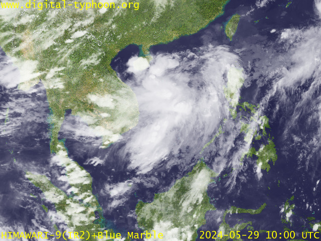
RECENT MTSAT-1R SATELLITE IMAGE:

> Image source: Digital-Typhoon.org (Nat'l. Institute of Informatics) (http://www.digital-typhoon.org )
__________________________________________________________________________________________
NOTES:

> Image source: Digital-Typhoon.
^ - JTWC commentary remarks (for Meteorologists) from their
latest warning.
latest warning.
* - Based on PAGASA's Philippine Storm Warning Signals,
# 4 being the highest. Red letters indicate new areas
being hoisted. For more explanations on these signals,
visit: http://www.typhoon2000.ph/signals.htm
** - Based on the Tropical Cyclone's Wave Height near
its center.
__________________________________________________________________________________________
>> To know the meteorological terminologies and acronyms
used on this update visit the ff:
http://typhoon2000.ph/tcterm.htm
http://www.nhc.noaa.gov/aboutgloss.shtml
http://www.srh.noaa.gov/oun/severewx/glossary.php
http://www.srh.weather.gov/fwd/glossarynation.html
http://www.nhc.noaa.gov/acronyms.shtml
__________________________________________________________________________________________
:: Typhoon2000.com (T2K) Mobile >> Powered by: Synermaxx
Receive the latest storm updates directly to your mobile phones! To know more:
Send T2K HELP to: 2800 (GLOBE & TM) | 216 (SMART & TNT) | 2288 (SUN)
Note: Globe & Smart charges P2.50 per message, while Sun at P2.00.
__________________________________________________________________________________________
For the complete details on TY XANGSANE (MILENYO)...go visit
our website @:
> http://www.typhoon2000.com
> http://www.maybagyo.com
# 4 being the highest. Red letters indicate new areas
being hoisted. For more explanations on these signals,
visit: http://www.typhoon2
** - Based on the Tropical Cyclone's Wave Height near
its center.
____________
>> To know the meteorological terminologies and acronyms
used on this update visit the ff:
http://typhoon2000.
http://www.nhc.
http://www.srh.
http://www.srh.
http://www.nhc.
____________
:: Typhoon2000.
Receive the latest storm updates directly to your mobile phones! To know more:
Send T2K HELP to: 2800 (GLOBE & TM) | 216 (SMART & TNT) | 2288 (SUN)
Note: Globe & Smart charges P2.50 per message, while Sun at P2.00.
For the complete details on TY XANGSANE (MILENYO)...
our website @:
> http://www.typhoon2
> http://www.maybagyo
Change settings via the Web (Yahoo! ID required)
Change settings via email: Switch delivery to Daily Digest | Switch format to Traditional
Visit Your Group | Yahoo! Groups Terms of Use | Unsubscribe
SPONSORED LINKS
.
__,_._,___
No comments:
Post a Comment