
Typhoon2000 STORM UPDATE #009
Name: TYPHOON CIMARON [PAENG/22W/0619]
Issued: 7:00 AM MANILA TIME (23:00 GMT) TUE 31 OCTOBER 2006
Next Update: 7:00 PM (11:00 GMT) TUE 31 OCTOBER 2006
Source: JTWC TROPICAL CYCLONE WARNING #017
_______________________________________________________________________
Next Update: 7:00 PM (11:00 GMT) TUE 31 OCTOBER 2006
Source: JTWC TROPICAL CYCLONE WARNING #017
____________
TYPHOON CIMARON (PAENG) SLOWS DOWN ABRUPTLY OVER THE
SOUTH CHINA SEA.
+ FORECAST OUTLOOK: CIMARON is expected to re-intensify SOUTH CHINA SEA.
over the South China Sea and move on a West to WSW track
in the direction of Vietnam. The 3 to 5-day (Nov 3-5)
long-range forecast shows CIMARON weakening but making
its 2nd landfall along Vietnam as a downgraded Tropical
Storm by Saturday morning, Nov 4...and dissipating over
Laos Sunday Nov 5.
+ EFFECTS: The system's outer bands continues to affect
La Union, Zambales, Western Pangasinan & Ilocos Provin-
ces...however improving weather conditions can be expec-
ted later today as the typhoon slowly moves away. The
rest of Luzon is now free from the storm's circulation.
Coastal Storm Surge flooding of more than 2 to 5 feet
above normal tide levels...along with large and dange-
rous battering waves can be expected along the western
coast of Luzon today.
outlook, effects & current monsoon intensity, and tropical
cyclone watch changes every 06 to 12 hours!
____________
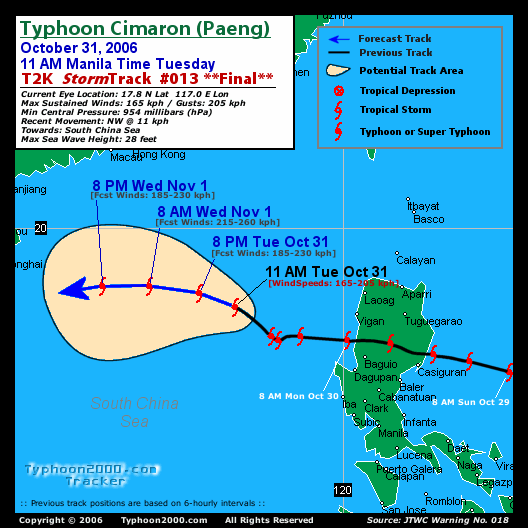
TIME/DATE: 5:00 AM MANILA TIME (21:00 GMT) 31 OCTOBER
LOCATION OF EYE: LATITUDE 17.1º N...LONGITUDE 117.7º E
DISTANCE 1: 290 KM (157 NM) WSW OF VIGAN CITY
DISTANCE 2: 315 KM (170 NM) WNW OF BAGUIO CITY
DISTANCE 3: 305 KM (165 NM) NW OF DAGUPAN CITY
DISTANCE 4: 460 KM (248 NM) NW OF METRO MANILA
PEAK WIND GUSTS: 205 KM/HR (110 KTS)
SAFFIR-SIMPSON SCALE: CATEGORY TWO (2)
MINIMUM CENTRAL PRESSURE (est.): 954 MILLIBARS (hPa)
RECENT MOVEMENT: WNW @ 03 KM/HR (02 KTS)
GENERAL DIRECTION: SOUTH CHINA SEA
STORM'S SIZE (IN DIAMETER): 555 KM (300 NM)/AVERAGE
MAX WAVE HEIGHT**: 28 FEET (8.5 METERS)
VIEW TRACKING MAP: 5 AM PST TUE OCTOBER 31
TSR WIND PROBABILITIES: CURRENT TO 120 HRS LEAD
PHILIPPINE STORM SIGNALS*:
#01 - LA UNION, PANGASINAN & ZAMBALES.
12, 24 & 48 HR. FORECAST:
2 PM (06 GMT) 31 OCT: 17.3N 116.9E / 185-230 KPH / W @ 13 KPH
2 AM (18 GMT) 01 NOV: 17.6N 115.4E / 215-260 KPH / W @ 13 KPH
2 AM (18 GMT) 02 NOV: 17.3N 112.7E / 165-205 KPH / W @ 11 KPH
12, 24 & 48 HR. FORECAST:
2 PM (06 GMT) 31 OCT: 17.3N 116.9E / 185-230 KPH / W @ 13 KPH
2 AM (18 GMT) 01 NOV: 17.6N 115.4E / 215-260 KPH / W @ 13 KPH
2 AM (18 GMT) 02 NOV: 17.3N 112.7E / 165-205 KPH / W @ 11 KPH
REMARKS: 2 AM (18 GMT) 31 OCTOBER POSITION: 17.0N 118.0E.
^TY Cimaron has slowed over the last six hours as it has
reached its closest Point of approach to a weakness in the
subtropical ridge (str) located over Taiwan. TY Cimaron
will track westward under the influence of the section of
the str currently located over Hainan Island. This steering
str will shift steadily westward through 36 hours to a new
position over northern laos. From 48 hours, TY Cimaron will
track west-southwestward along the southeastern periphery
of the str...(more info)
>> CIMARON {pronounced: see~mah~ron}
Wild Ox. Name contributed by: Philippines
____________
____________
PAGASA CURRENT POSITION, MOVEMENT AND INTENSITY (10-min. ave.):
> 4 AM (20 GMT) 31 OCTOBER: 16.7N 117.5E / WSW @ 13 KPH / 120 kph
:: For the complete PAGASA bulletin, kindly visit their website
at: http://www.pagasa.dost.gov.ph/wb/tcupdate.shtml
:: For the complete PAGASA bulletin, kindly visit their website
at: http://www.pagasa.
_______________________________________________________________________
RECENT T2K TRACKING CHART:
________________________
RECENT MTSAT-1R SATELLITE IMAGE:

> Image source: Digital-Typhoon.org (Nat'l. Institute of Informatics) (http://www.digital-typhoon.org )
__________________________________________________________________________________________
NOTES:
> Image source: Digital-Typhoon.
^ - JTWC commentary remarks (for Meteorologists) from their
latest warning.
latest warning.
* - Based on PAGASA's Philippine Storm Warning Signals,
# 4 being the highest. Red letters indicate new areas
being hoisted. For more explanations on these signals,
visit: http://www.typhoon2000.ph/signals.htm
** - Based on the Tropical Cyclone's Wave Height near
its center.
__________________________________________________________________________________________
>> To know the meteorological terminologies and acronyms
used on this update visit the ff:
http://typhoon2000.ph/tcterm.htm
http://www.nhc.noaa.gov/aboutgloss.shtml
http://www.srh.noaa.gov/oun/severewx/glossary.php
http://www.srh.weather.gov/fwd/glossarynation.html
http://www.nhc.noaa.gov/acronyms.shtml
__________________________________________________________________________________________
:: Typhoon2000.com (T2K) Mobile >> Powered by: Synermaxx
Receive the latest storm updates directly to your mobile phones! To know more:
Send T2K HELP to: 2800 (GLOBE & TM) | 216 (SMART & TNT) | 2288 (SUN)
Note: Globe & Smart charges P2.50 per message, while Sun at P2.00.
__________________________________________________________________________________________
For the complete details on TY CIMARON (PAENG)...go visit
our website @:
> http://www.typhoon2000.com
> http://www.maybagyo.com
# 4 being the highest. Red letters indicate new areas
being hoisted. For more explanations on these signals,
visit: http://www.typhoon2
** - Based on the Tropical Cyclone's Wave Height near
its center.
____________
>> To know the meteorological terminologies and acronyms
used on this update visit the ff:
http://typhoon2000.
http://www.nhc.
http://www.srh.
http://www.srh.
http://www.nhc.
____________
:: Typhoon2000.
Receive the latest storm updates directly to your mobile phones! To know more:
Send T2K HELP to: 2800 (GLOBE & TM) | 216 (SMART & TNT) | 2288 (SUN)
Note: Globe & Smart charges P2.50 per message, while Sun at P2.00.
For the complete details on TY CIMARON (PAENG)...go visit
our website @:
> http://www.typhoon2
> http://www.maybagyo
Change settings via the Web (Yahoo! ID required)
Change settings via email: Switch delivery to Daily Digest | Switch format to Traditional
Visit Your Group | Yahoo! Groups Terms of Use | Unsubscribe
SPONSORED LINKS
.
__,_._,___

No comments:
Post a Comment