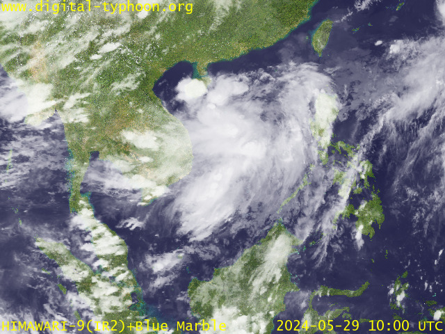
Typhoon2000 STORM UPDATE #001
Name: TROPICAL DEPRESSION OMPONG [91W]
Issued: 7:00 PM MANILA TIME (11:00 GMT) THU 12 OCTOBER 2006
Next Update: 7:00 AM (23:00 GMT) FRI 13 OCTOBER 2006
Source: PAGASA TC WARNING FOR SHIPPING #002
_______________________________________________________________________
Next Update: 7:00 AM (23:00 GMT) FRI 13 OCTOBER 2006
Source: PAGASA TC WARNING FOR SHIPPING #002
____________
TROPICAL DEPRESSION OMPONG (91W) NEWLY FORMED OVER THE
PHILIPPINE SEA...MIGHT THREATEN CENTRAL AND NORTHERN
LUZON THIS WEEKEND.
...ALL INTERESTS IN THE CENTRAL & NORTHERN LUZON AND
PHILIPPINE SEA...MIGHT THREATEN CENTRAL AND NORTHERN
LUZON THIS WEEKEND.
...ALL INTERESTS IN THE CENTRAL & NORTHERN LUZON AND
BICOL REGION SHOULD CLOSELY MONITOR THE PROGRESS OF OMPONG.
+ FORECAST OUTLOOK: OMPONG is expected to drift slowly West
or WSW across the Philippine Sea for the next 2 to 3 days.
+ EFFECTS: OMPONG's circulation especially the Western Outer
Bands will continue to affect the Eastern Coastal Areas of
Luzon and Bicol Peninsula tonight and tomorrow. These outer
bands shall bring light to moderate rainfall associated with
passing squalls & increasing Northerly to NW'ly winds of not
more than 35 km/hr. People living along mountain slopes,
river banks & low-lying areas must take extra-precautions
against mudslides and flash floods caused by heavy rains.
against mudslides and flash floods caused by heavy rains.
Important Note: Please keep in mind that the above forecast
outlook, effects & current monsoon intensity, and tropical
cyclone watch changes every 06 to 12 hours!
_______________________________________________________________________
TIME/DATE: 2:00 PM MANILA TIME (06:00 GMT) 12 OCTOBER
LOCATION OF CENTER: LATITUDE 16.0º N...LONGITUDE 129.3º E
DISTANCE 1: 610 KM (330 NM) NE OF VIRAC, CATANDUANES, PH
outlook, effects & current monsoon intensity, and tropical
cyclone watch changes every 06 to 12 hours!
____________
TIME/DATE: 2:00 PM MANILA TIME (06:00 GMT) 12 OCTOBER
LOCATION OF CENTER: LATITUDE 16.0º N...LONGITUDE 129.3º E
DISTANCE 1: 610 KM (330 NM) NE OF VIRAC, CATANDUANES, PH
DISTANCE 2: 710 KM (383 NM) ENE OF NAGA CITY, PH
PEAK WIND GUSTS: 70 KM/HR (38 KTS)
SAFFIR-SIMPSON SCALE: N/A
MINIMUM CENTRAL PRESSURE (est.): 1000 MILLIBARS (hPa)
RECENT MOVEMENT: WEST @ 03 KM/HR (02 KTS)
GENERAL DIRECTION: EASTERN LUZON
STORM'S SIZE (IN DIAMETER): 400 KM (215 NM)/AVERAGE
MAX WAVE HEIGHT**: 10 FEET (3.0 METERS)
VIEW PAGASA TRACKING MAP: 2 PM PST THU OCTOBER 12
TSR WIND PROBABILITIES: N/A
PHILIPPINE STORM SIGNALS*: N/A.
24, 48 & 72 HR. FORECAST:
2 PM (06 GMT) 13 OCT: 16.0N 128.4E
2 PM (06 GMT) 14 OCT: 15.9N 127.5E
DISTANCE 3: 770 KM (415 NM) EAST OF CASIGURAN, AURORA, PH
DISTANCE 4: 895 KM (483 NM) ENE OF METRO MANILA, PH
MAX SUSTAINED WINDS [10-MIN AVG]: 55 KM/HR (30 KTS)PEAK WIND GUSTS: 70 KM/HR (38 KTS)
SAFFIR-SIMPSON SCALE: N/A
MINIMUM CENTRAL PRESSURE (est.): 1000 MILLIBARS (hPa)
RECENT MOVEMENT: WEST @ 03 KM/HR (02 KTS)
GENERAL DIRECTION: EASTERN LUZON
STORM'S SIZE (IN DIAMETER): 400 KM (215 NM)/AVERAGE
MAX WAVE HEIGHT**: 10 FEET (3.0 METERS)
VIEW PAGASA TRACKING MAP: 2 PM PST THU OCTOBER 12
TSR WIND PROBABILITIES: N/A
PHILIPPINE STORM SIGNALS*: N/A.
24, 48 & 72 HR. FORECAST:
2 PM (06 GMT) 13 OCT: 16.0N 128.4E
2 PM (06 GMT) 14 OCT: 15.9N 127.5E
2 PM (06 GMT) 15 OCT: 15.7N 126.7E
REMARKS: X PM (XX GMT) 12 OCTOBER POSITION: XX.XN XXX.XE.
_______________________________________________________________________
_______________________________________________________________________
RECENT PAGASA TRACKING CHART:
REMARKS: X PM (XX GMT) 12 OCTOBER POSITION: XX.XN XXX.XE.
____________
____________
RECENT PAGASA TRACKING CHART:
RECENT MTSAT-1R SATELLITE IMAGE:

> Image source: Digital-Typhoon.org (Nat'l. Institute of Informatics) (http://www.digital-typhoon.org )
__________________________________________________________________________________________
NOTES:

> Image source: Digital-Typhoon.
^ - JTWC commentary remarks (for Meteorologists) from their
latest warning.
latest warning.
* - Based on PAGASA's Philippine Storm Warning Signals,
# 4 being the highest. Red letters indicate new areas
being hoisted. For more explanations on these signals,
visit: http://www.typhoon2000.ph/signals.htm
** - Based on the Tropical Cyclone's Wave Height near
its center.
__________________________________________________________________________________________
>> To know the meteorological terminologies and acronyms
used on this update visit the ff:
http://typhoon2000.ph/tcterm.htm
http://www.nhc.noaa.gov/aboutgloss.shtml
http://www.srh.noaa.gov/oun/severewx/glossary.php
http://www.srh.weather.gov/fwd/glossarynation.html
http://www.nhc.noaa.gov/acronyms.shtml
__________________________________________________________________________________________
:: Typhoon2000.com (T2K) Mobile >> Powered by: Synermaxx
Receive the latest storm updates directly to your mobile phones! To know more:
Send T2K HELP to: 2800 (GLOBE & TM) | 216 (SMART & TNT) | 2288 (SUN)
Note: Globe & Smart charges P2.50 per message, while Sun at P2.00.
Offline Status: Servers under migration to a new location..services will resume
October 16 or 17 (Monday or Tuesday). Sorry for the inconvenience.
__________________________________________________________________________________________
For the complete details on TD OMPONG (91W)...go visit
our website @:
> http://www.typhoon2000.com
> http://www.maybagyo.com
# 4 being the highest. Red letters indicate new areas
being hoisted. For more explanations on these signals,
visit: http://www.typhoon2
** - Based on the Tropical Cyclone's Wave Height near
its center.
____________
>> To know the meteorological terminologies and acronyms
used on this update visit the ff:
http://typhoon2000.
http://www.nhc.
http://www.srh.
http://www.srh.
http://www.nhc.
____________
:: Typhoon2000.
Receive the latest storm updates directly to your mobile phones! To know more:
Send T2K HELP to: 2800 (GLOBE & TM) | 216 (SMART & TNT) | 2288 (SUN)
Note: Globe & Smart charges P2.50 per message, while Sun at P2.00.
Offline Status: Servers under migration to a new location..services will resume
October 16 or 17 (Monday or Tuesday). Sorry for the inconvenience.
For the complete details on TD OMPONG (91W)...go visit
our website @:
> http://www.typhoon2
> http://www.maybagyo
Change settings via the Web (Yahoo! ID required)
Change settings via email: Switch delivery to Daily Digest | Switch format to Traditional
Visit Your Group | Yahoo! Groups Terms of Use | Unsubscribe
SPONSORED LINKS
.
__,_._,___

No comments:
Post a Comment