Thursday, December 27, 2012

LPA WUKONG (QUINTA) Final Update


for Thursday, 27 December 2012 [12:51 PM PhT]

WEATHER.COM.PH / T2K TROPICAL CYCLONE UPDATES

TROPICAL DISTURBANCE (LPA) WUKONG (QUINTA) UPDATE NUMBER 009 [Final]
Issued: 1:00 PM PhT (05:00 GMT) Thursday 27 Dec 2012

Wukong (Quinta) continues to dissipate...just an area of low pressure, or Tropical Disturbance moving across the West Philippine Sea away from Palawan.

This disturbance will continue to enhance the strong Northeast Monsoon (Amihan) and bring moderate to strong winds with "on-and-off" slight rains across Eastern & Southern Luzon including Metro Manila, becoming more frequent along the Bicol Region.


This is the last and final update on Wukong (Quinta).

Do not use this for life or death decision. This update is intended for additional information purposes only. Kindly refer to your national weather agency for official warnings, advisories or bulletins.


CURRENT STORM ANALYSIS

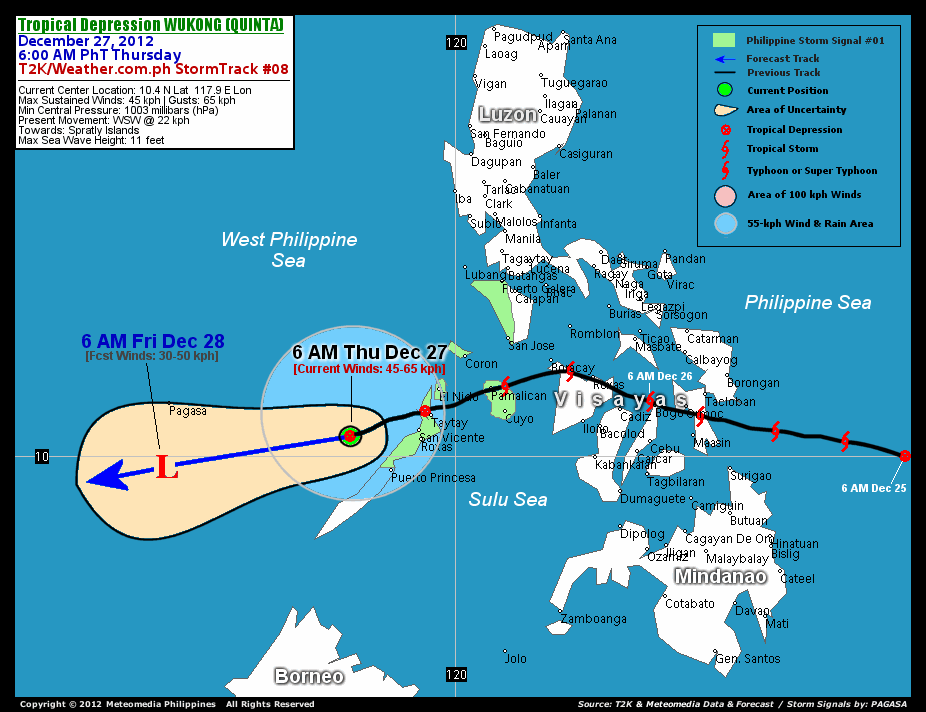
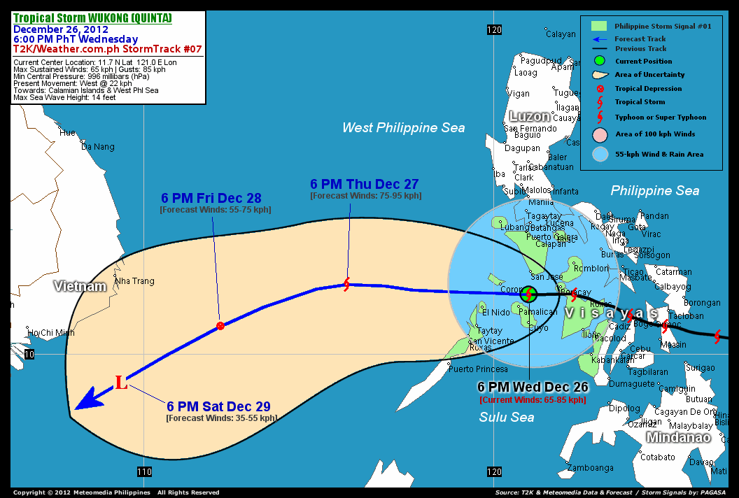
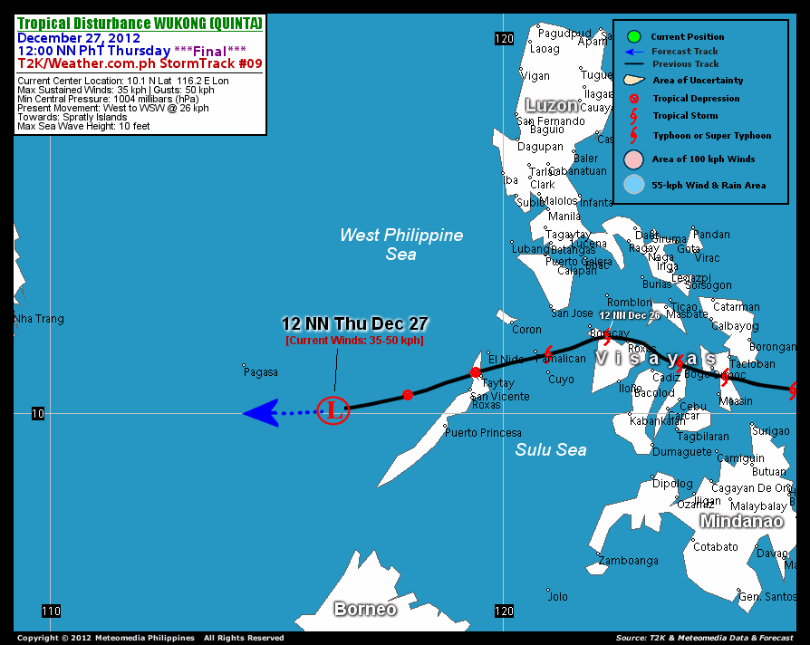
As of 12 noon today, the ill-defined center of Tropical Disturbance Wukong (Quinta) was located over the West Philippine Sea...about 277 km west-northwest of Puerto Princesa, Palawan or 236 km southeast of Pagasa Island, Spratlys...currently moving west to west-southwestward with a forward speed of 26 km/hr in the general direction of the Spratly Islands.

Maximum Sustained Winds (1-min. avg) have decreased to 35 km/hr near the center with higher gusts. Yesterday, a WeatherPhilippines/Meteomedia Automated Weather Station (AWS) situated in Bacolod City has recorded wind gusts of 70 km/hr blowing from the northwest at 8:00 AM. Meanwhile, various AWS also recorded 24-hour rainfall accumulations between 20-150 millimeters around Negros and Panay Islands, with Cadiz City in Negros Occidental as the highest rainfall recorded.


EFFECTS & HAZARDS SUMMARY

Below is the summary of the storm's parts and its hazards affecting specific areas. You can also view this image link for you to understand the parts.

DECAYING RAINBANDS - affecting and spreading across Palawan including the Calamian Islands. Tropical Disturbance Conditions with light to moderate winds (<35 kph) will be expected along these bands (click here to know more about Rainbands).
24HR TOTAL RAINFALL ACCUMULATION - from 5 up to 25 mm (slight to moderate rainfall) can be expected along areas affected by the decaying rainbands (see above) of Ex-TD Wukong (Quinta).

Important Note: Please keep in mind that the above forecast outlook, effects and hazards summary changes every 6 to 12 hrs!


CURRENT TECHNICAL INFORMATION

Time/Date: 12:00 NN PhT Thu December 27, 2012
Class/Name: Ex-TD (LPA) Wukong (Quinta)
Location of Center: 10.1º N Lat 116.2º E Lon
Distance 1: 236 km (SE) from Pagasa Is., Spratlys
Distance 2: 277 km (WNW) away from Puerto Princesa
Distance 3: 340 km (W) away from Roxas, Palawan
Distance 4: 342 km (WSW) away from San Vicente, Palawan
Distance 5: 369 km (WSW) away from Taytay, Palawan
MaxWinds (1-min avg): 35 kph near the center
Peak Wind Gusts: 50 kph
Present Movement: West @ 26 kph
Towards: Spratly Islands
CPA [ETA] to Spratlys: Tonight [8-10PM PhT]
24hr Rainfall Accum (near center): Slight/Moderate [25 mm]
Minimum Central Pressure: 1004 millibars (hPa)
Size (in Diameter): 445 km [Average]
Max Sea Wave Height (near center): 10 feet
Possible Storm Surge Height: 0 ft (0 m)

T2K/WP StormTracks (for Public): GIF | Google Map (Flash)


__________________________________________________________________________________________________

CURRENT NOAA/MTSAT-2 SATELLITE ANIMATION:

http://www.ssd.noaa.gov/PS/TROP/floaters/27W/imagery/rgb-animated.gif


CURRENT NOAA/MTSAT-2 INFRARED SATELLITE IMAGE
:

http://www.ssd.noaa.gov/PS/TROP/floaters/27W/imagery/rb0-lalo.jpg


CURRENT TRACKING CHART:


http://www.typhoon2000.ph/advisorytrax/2012/quinta09.gif

_____________________________________________________________________________


NOTE:

>> To know the meteorological terminologies and acronyms used on this update visit the ff:

   
http://typhoon2000.ph/tcterm.htm  
   
http://www.nhc.noaa.gov/aboutgloss.shtml
    http://www.nhc.noaa.gov/acronyms.shtml
__________________________________________________________________________________________

For the complete details on Ex-TD WUKONG (QUINTA)...go visit our website @:

>
http://www.typhoon2000.com
http://www.maybagyo.com

:: Kindly view our site's disclaimer at: 
   
http://www.typhoon2000.ph/disclaimer.htm
__________________________________________________________________________________________

<<<Typhoon2000.com Mobile >>>
Get the latest SMS Storm Alerts!
For more details: Text T2K TYPHOON to

2800 (Globe/TM) | 216 (Smart/TNT) | 2288 (Sun)
*Only P2.50 (Smart/Globe) / P2.00 (Sun) per msg received.

Click here on how to use this service (in PDF file)
Powered by: Synermaxx Corporation


Copyright © 2012 Typhoon2000.com     All Rights Reserved

__._,_.___
Reply via web post Reply to sender Reply to group Start a New Topic Messages in this topic (1)
Recent Activity:
.

__,_._,___

TD WUKONG (QUINTA) - Update #008


for Thursday, 27 December 2012 [7:20 AM PhT]

WEATHER.COM.PH / T2K TROPICAL CYCLONE UPDATES

TROPICAL DEPRESSION WUKONG (QUINTA) UPDATE NUMBER 008
Issued: 7:00 AM PhT (23:00 GMT) Thursday 27 Dec 2012
Next Update: 1:00 PM PhT (23:00 GMT) Thursday 27 Dec 2012


Wukong (Quinta) has weakened rapidly into a weak Tropical Depression as it turns west-southwestward across the West Philippine Sea...now passing to the northwest of Palawan.

Wukong (Quinta) will continue to enhance the strong Northeast Monsoon (Amihan) and bring moderate to strong winds with "on-and-off" slight rains across Eastern & Southern Luzon including Metro Manila, becoming moderate to heavy rains over the Bicol Region.

Residents and visitors along Palawan and Spratly Islands should closely monitor the development of Wukong (Quinta).

Do not use this for life or death decision. This update is intended for additional information purposes only. Kindly refer to your national weather agency for official warnings, advisories or bulletins.


CURRENT STORM ANALYSIS

As of 6 AM today, the center of Tropical Depression Wukong (Quinta) was located over the West Philippine Sea...about 110 km northwest of Puerto Princesa, Palawan or 401 km east-southeast of Pagasa Island, Spratlys...currently moving west-southwestward with a forward speed of 22 km/hr in the general direction of the Spratly Islands.

Maximum Sustained Winds (1-min. avg) have decreased to 45 km/hr near the center with higher gusts. Yesterday, a WeatherPhilippines/Meteomedia Automated Weather Station (AWS) situated in Bacolod City has recorded wind gusts of 70 km/hr blowing from the northwest at 8:00 AM. Meanwhile, various AWS also recorded 24-hour rainfall accumulations between 20-150 millimeters around Negros and Panay Islands, with Cadiz City in Negros Occidental as the highest rainfall recorded. Wukong (Quinta) is an average-sized tropical cyclone with a diameter of 445 kilometers across. The 24-hour rainfall accumulation near and to north of the center of TS Wukong (Quinta) is estimated to be slight to moderate (25 mm).


1-DAY FORECAST OUTLOOK*

Tropical Depression Wukong (Quinta) is expected to continue moving west-southwest throughout the forecast period. On the forecast track, the core of Wukong (Quinta) is expected to pass over the Spratly Islands tonight or Friday.

WUKONG (Quinta) is forecast to dissipate within the next 12 to 24 hours as it moves into the hostile atmospheric environment of the West Philippine Sea.

The following is the summary of the 1-day forecast outlook on this system:

FRIDAY MORNING: Dissipated as an area of low pressure over the Spratly Islands...about 493 km west of Puerto Princesa, Palawan [6AM DEC 28: 9.8N 114.2E @ 30kph].

*Please be reminded that the Forecast Outlook changes every 6 hours, and the Day 3 Forecast Track have an average error of 250 km...while the wind speed forecast error, averages 35 kph per day. Therefore, a turn to the left or right of its future track and changes in its wind speed must be anticipated from time to time.


EFFECTS & HAZARDS SUMMARY

Below is the summary of the storm's parts and its hazards affecting specific areas. You can also view this image link for you to understand the parts.

DECAYING RAINBANDS - affecting and spreading across Palawan including the Calamian Islands. Tropical Depression Conditions with moderate to strong winds (<62 kph) will be expected along these bands (click here to know more about Rainbands).
24HR TOTAL RAINFALL ACCUMULATION - from 5 up to 25 mm (slight to moderate rainfall) can be expected along areas affected by the decaying rainbands (see above) of Wukong (Quinta).

Important Note: Please keep in mind that the above forecast outlook, effects and hazards summary changes every 6 to 12 hrs!


CURRENT TECHNICAL INFORMATION

Time/Date: 6:00 AM PhT Thu December 27, 2012
Class/Name: TD Wukong (Quinta)
Location of Center: 10.4º N Lat 117.9º E Lon
Distance 1: 110 km (NW) away from Puerto Princesa
Distance 2: 153 km (W) away from San Vicente, Palawan
Distance 3: 155 km (W) away from Roxas, Palawan
Distance 4: 180 km (WSW) away from Taytay, Palawan
Distance 5: 226 km (WSW) away from El Nido, Palawan
Distance 6: 308 km (SW) away from Coron, Palawan
Distance 7: 325 km (WSW) away from Amanpulo, Pamalican Is.
Distance 8: 343 km (WSW) away from Cuyo Island
Distance 9: 401 km (ESE) from Pagasa Is., Spratlys
Distance 10: 582 km (SSW) away from Metro Manila
MaxWinds (1-min avg): 45 kph near the center
Peak Wind Gusts: 65 kph
Present Movement: WSW @ 22 kph
Towards: Spratly Islands
CPA [ETA] to Spratlys: Fri Morning [5-7AM PhT]
24hr Rainfall Accum (near center): Slight/Moderate [25 mm]
Minimum Central Pressure: 1003 millibars (hPa)
Size (in Diameter): 445 km [Average]
Max Sea Wave Height (near center): 11 feet
Possible Storm Surge Height: 0 ft (0 m)

T2K/WP StormTracks (for Public): GIF | Google Map (Flash)


__________________________________________________________________________________________________

CURRENT NOAA/MTSAT-2 SATELLITE ANIMATION:

http://www.ssd.noaa.gov/PS/TROP/floaters/27W/imagery/rgb-animated.gif


CURRENT NOAA/MTSAT-2 INFRARED SATELLITE IMAGE
:

http://www.ssd.noaa.gov/PS/TROP/floaters/27W/imagery/rb0-lalo.jpg


CURRENT TRACKING CHART:


http://www.typhoon2000.ph/advisorytrax/2012/quinta08.gif

_____________________________________________________________________________


NOTE:

>> To know the meteorological terminologies and acronyms used on this update visit the ff:

   
http://typhoon2000.ph/tcterm.htm  
   
http://www.nhc.noaa.gov/aboutgloss.shtml
    http://www.nhc.noaa.gov/acronyms.shtml
__________________________________________________________________________________________

For the complete details on TD WUKONG (QUINTA)...go visit our website @:

>
http://www.typhoon2000.com
http://www.maybagyo.com

:: Kindly view our site's disclaimer at: 
   
http://www.typhoon2000.ph/disclaimer.htm
__________________________________________________________________________________________

<<<Typhoon2000.com Mobile >>>
Get the latest SMS Storm Alerts!
For more details: Text T2K TYPHOON to

2800 (Globe/TM) | 216 (Smart/TNT) | 2288 (Sun)
*Only P2.50 (Smart/Globe) / P2.00 (Sun) per msg received.

Click here on how to use this service (in PDF file)
Powered by: Synermaxx Corporation


Copyright © 2012 Typhoon2000.com     All Rights Reserved

__._,_.___
Reply via web post Reply to sender Reply to group Start a New Topic Messages in this topic (1)
Recent Activity:
.

__,_._,___

Wednesday, December 26, 2012

TS WUKONG (QUINTA) - Update #007


for Wednesday, 26 December 2012 [7:27 PM PhT]

WEATHER.COM.PH / T2K TROPICAL CYCLONE UPDATES

TROPICAL STORM WUKONG (QUINTA) UPDATE NUMBER 007
Issued: 7:00 PM PhT (11:00 GMT) Wednesday 26 Dec 2012
Next Update: 7:00 AM PhT (23:00 GMT) Thursday 27 Dec 2012


Tropical Storm Wukong (Quinta) is now emerging over the northern part of Sulu Sea after it crossed Northern Panay...approaching the Calamian Islands. Storm's rainbands continues to affect Western Visayas, Mindoro, and the Calamian Islands.

Wukong (Quinta) will continue to enhance the Northeast Monsoon (Amihan) and bring moderate to strong winds with "on-and-off" rains across Eastern & Southern Luzon including Metro Manila and Bicol Region tonight.

Residents and visitors along Southwestern Luzon including Mindoro, Western Visayas and Northern Palawan should closely monitor the development of Wukong (Quinta).

Do not use this for life or death decision. This update is intended for additional information purposes only. Kindly refer to your national weather agency for official warnings, advisories or bulletins.


CURRENT STORM ANALYSIS

As of 6 AM today, the center of Tropical Storm Wukong (Quinta) was located over Sulu Sea...about 47 km north-northeast of Amanpulo, Pamalican Island or 79 km south of San Jose, Occidental Mindoro...currently moving westward with a forward speed of 22 km/hr in the general direction of Calamian Islands and the West Philippine Sea.

Maximum Sustained Winds (1-min. avg) are at 65 km/hr near the center with higher gusts. Tropical Storm Force Winds (62-117 km/hr) extend outward up to 15 kilometers from the center. A WeatherPhilippines/Meteomedia Automated Weather Station (AWS) situated in Bacolod City has recorded wind gusts of 70 km/hr blowing from the northwest at 8:00 AM this morning. Meanwhile, various AWS also recorded 24-hour rainfall accumulations between 20-130 millimeters around Negros and Panay Islands, with Cadiz City in Negros Occidental as the highest rainfall recorded. Wukong (Quinta) is an average-sized tropical cyclone with a diameter of 445 kilometers across. The 24-hour rainfall accumulation near and to north of the center of TS Wukong (Quinta) is estimated to be heavy (210 mm).


3-DAY FORECAST OUTLOOK*

Tropical Storm Wukong (Quinta) is expected to continue moving westward during the next 12 to 24 hours...with a turn to the west-southwest around 36 to 72 hours. On the forecast track, the core of Wukong (Quinta) is expected to pass over the Calamian Group of Islands later tonight...and will be over the West Philippine Sea on Thursday. This storm should move out of the Philippine Area of Responsibility (PAR) on Thursday evening. On Friday and Saturday, Wukong (Quinta) should be moving across the South China Sea, well to the southeast of Vietnam.

WUKONG (Quinta) is forecast to slightly re-intensify during the next 12 to 24 hours as it moves into the warm waters of the Sulu and West Philippine Seas later this evening until Thursday.

The following is the summary of the 3-day forecast outlook on this system:

THURSDAY EVENING: Gains strength as it moves over the West Philippine Sea...about 478 km west of Coron, Palawan [6PM DEC 27: 12.0N 115.8E @ 75kph].
FRIDAY EVENING: Exits the Philippine Area of Responsibility (PAR) as it turns west-southwest across the South China Sea...downgraded into a Tropical Depression (TD)...about 362 km southeast of Nha Trang, Vietnam [6PM DEC 28: 10.8N 112.2E @ 55kph].
SATURDAY EVENING: Still moving west-southwest while over the South China Sea...dissipated into an area of low pressure...about 336 km southeast of Ho Chi Minh City, Vietnam [6PM DEC 29: 9.2N 109.3E @ 35kph].

*Please be reminded that the Forecast Outlook changes every 6 hours, and the Day 3 Forecast Track have an average error of 250 km...while the wind speed forecast error, averages 35 kph per day. Therefore, a turn to the left or right of its future track and changes in its wind speed must be anticipated from time to time.


EFFECTS & HAZARDS SUMMARY

Below is the summary of the storm's parts and its hazards affecting specific areas. You can also view this image link for you to understand the parts.

INNER RAINBANDS - affecting and spreading across Northern Panay, Boracay, Mindoro Provinces, Romblon-Tablas Islands, and Calamian Islands. Tropical Storm Conditions with Tropical Storm Force Winds (62-85 kph) will be expected along these bands.
OUTER RAINBANDS - affecting and spreading across Bicol Region including Masbate, Ticao-Burias Islands, Southern Panay, Negros, Northern Palawan, Marinduque, Lubang Island and Southern Tagalog Provinces. Tropical Depression Conditions with moderate to strong winds (<62 kph) will be expected along these bands (click here to know more about Rainbands).
24HR TOTAL RAINFALL ACCUMULATION - from 5 up to 100 mm (slight to heavy rainfall) can be expected along areas affected by the outer & inner rainbands (see above)...with isolated amounts of 101 to 210 mm (heavy) along areas near and north of the center of Wukong (Quinta).

Important Note: Please keep in mind that the above forecast outlook, effects and hazards summary changes every 6 to 12 hrs!


CURRENT TECHNICAL INFORMATION

Time/Date: 6:00 PM PhT Wed December 26, 2012
Class/Name: TS Wukong (Quinta)
Location of Center: 11.7º N Lat 121.0º E Lon
Distance 1: 47 km (NNE) from Amanpulo, Pamalican Is.
Distance 2: 79 km (S) from San Jose, Occ.Mindoro
Distance 3: 89 km (N) from Cuyo Island
Distance 4: 93 km (ESE) from Coron, Palawan
Distance 5: 100 km (WSW) away from Boracay
Distance 6: 148 km (ENE) from El Nido
Distance 7: 196 km (W) away from Roxas City
Distance 8: 198 km (NW) away from Iloilo City
Distance 9: 200 km (S) from Puerto Galera
Distance 10: 241 km (NW) away from Bacolod City
Distance 11: 323 km (S) from Metro Manila
MaxWinds (1-min avg): 65 kph near the center
Peak Wind Gusts: 85 kph
Present Movement: West @ 22 kph
Towards: Calamian Islands
CPA [ETA] to Calamian Group: Tonight [9-11PM PhT]
24hr Rainfall Accum (near center): Heavy [210 mm]
Minimum Central Pressure: 996 millibars (hPa)
Size (in Diameter): 445 km [Average]
Max Sea Wave Height (near center): 14 feet
Possible Storm Surge Height: 1-3 ft (0.3-0.9 m)

T2K/WP StormTracks (for Public): GIF | Google Map (Flash)


__________________________________________________________________________________________________

CURRENT NOAA/MTSAT-2 SATELLITE ANIMATION:

http://www.ssd.noaa.gov/PS/TROP/floaters/27W/imagery/rgb-animated.gif


CURRENT NOAA/MTSAT-2 INFRARED SATELLITE IMAGE
:

http://www.ssd.noaa.gov/PS/TROP/floaters/27W/imagery/rb0-lalo.jpg


CURRENT TRACKING CHART:


http://www.typhoon2000.ph/advisorytrax/2012/quinta07.gif

_____________________________________________________________________________


NOTE:

>> To know the meteorological terminologies and acronyms used on this update visit the ff:

   
http://typhoon2000.ph/tcterm.htm  
   
http://www.nhc.noaa.gov/aboutgloss.shtml
    http://www.nhc.noaa.gov/acronyms.shtml
__________________________________________________________________________________________

For the complete details on TS WUKONG (QUINTA)...go visit our website @:

>
http://www.typhoon2000.com
http://www.maybagyo.com

:: Kindly view our site's disclaimer at: 
   
http://www.typhoon2000.ph/disclaimer.htm
__________________________________________________________________________________________

<<<Typhoon2000.com Mobile >>>
Get the latest SMS Storm Alerts!
For more details: Text T2K TYPHOON to

2800 (Globe/TM) | 216 (Smart/TNT) | 2288 (Sun)
*Only P2.50 (Smart/Globe) / P2.00 (Sun) per msg received.

Click here on how to use this service (in PDF file)
Powered by: Synermaxx Corporation


Copyright © 2012 Typhoon2000.com     All Rights Reserved

__._,_.___
Reply via web post Reply to sender Reply to group Start a New Topic Messages in this topic (1)
Recent Activity:
.

__,_._,___