
WEATHER.COM.PH / T2K TROPICAL CYCLONE UPDATES
SUPER TYPHOON BOPHA (PABLO) UPDATE NUMBER 025
Issued: 7:00 AM PhT (23:00 GMT) Tuesday 04 Dec 2012
Next Update: 1:00 PM PhT (05:00 GMT) Tuesday 04 Dec 2012
The eye of Super Typhoon Bopha (Pablo) has made landfall over Cateel, Davao Oriental around 5 am...and is now moving across the northern part of Davao Oriental.
Important Note: Super Typhoon Bopha (Pablo) is almost three times the strength of Tropical Storm Washi (Sendong) which crossed North-Central Mindanao on December 16, 2011. Please take all precautionary measures on this dangerous cyclone. Refer to your national disaster agencies for more details.
Residents and visitors along Mindanao and Visayas should closely monitor the development of Bopha (Pablo).
Do not use this for life or death decision. This update is intended for additional information purposes only. Kindly refer to your national weather agency for official warnings, advisories or bulletins.
CURRENT STORM ANALYSIS
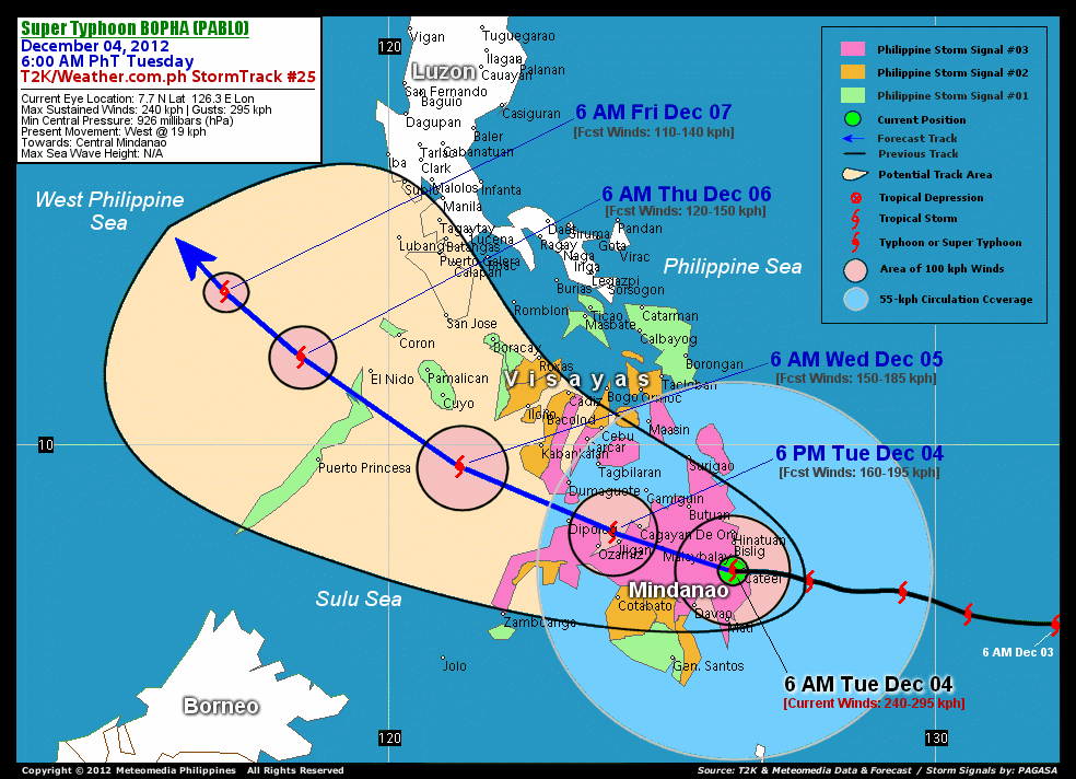
As of 6 am today, the eye of Super Typhoon Bopha was located over the northern part of Davao Oriental...about 22 km west of Cateel or 56 km south of Bislig City, Surigao Del Sur...currently moving west to west-northwest with a forward speed of 19 km/hr in the general direction of Bukidnon and Misamis Oriental.
Maximum Sustained Winds (1-min. avg) have decreased to 240 km/hr near the center with higher gusts. Typhoon Force Winds (118 km/hr or more) extend outward up to 65 kilometers from the center...and Tropical Storm Force Winds (62-117 km/hr) extend outward up to 220 kilometers. Bopha remains a large-sized tropical cyclone with a diameter of 775 kilometers across. The 24-hour rainfall accumulation near the center of Typhoon Bopha is estimated to be extreme (400 mm).
3-DAY FORECAST OUTLOOK*
Super Typhoon Bopha is expected to continue moving west to west-northwest for the next 24 hours with a slight decrease in its forward speed. After 24 hours, its track will turn to the northwest...and this motion will continue throughout the forecast period. On the forecast track, the core of Bopha is expected to continue traversing along the Davao Del Norte and Agusan Del Sur Border...and should cross Bukidnon around noon today. Bopha is likely to move across the southern part of Misamis Oriental later this afternoon, passing in between the cities of Iligan and Cagayan De Oro before sunset today. By Tuesday evening, the typhoon should emerge over the coast of Misamis Occidental passing very close to Dipolog City before midnight of Wednesday. On Wednesday morning, it should be moving across the Sulu Sea, crossing Northern Palawan Wednesday evening. By Thursday and Friday, Bopha shall be over the West Philippine Sea.
Bopha will continue to weaken upon crossing the mountains of Central Mindanao today. Further weakening will be anticipated once the typhoon emerges over the Sulu and West Philippine Sea due to the surge of cool northeast monsoon from mainland China.
The following is the summary of the 3-day forecast outlook on this system:
 WEDNESDAY MORNING: Over Sulu Sea...weakens to a Category 1 Typhoon as it turns northwestward...about 285 km east of Puerto Princesa, Palawan [6AM DEC 05: 9.6N 121.3E @ 150kph].
THURSDAY MORNING: Moving into the West Philippine Sea, just barely a Typhoon...about 146 km west-northwest of El Nido, Northern Palawan [6AM DEC 06: 11.6N 118.4E @ 120kph].
FRIDAY MORNING: Weakens to a Tropical Storm while over the West Philippine Sea...moving northwest slowly away from the Philippines...about 359 km west-northwest of Coron, Calamian Group [6AM DEC 07: 12.8N 117.0E @ 110kph].
*Please be reminded that the Forecast Outlook changes every 6 hours, and the Day 3 Forecast Track have an average error of 250 km...while the wind speed forecast error, averages 35 kph per day. Therefore, a turn to the left or right of its future track and changes in its wind speed must be anticipated from time to time.
EFFECTS & HAZARDS SUMMARY
Below is the summary of the storm's parts and its hazards affecting specific areas. You can also view this image link for you to understand the parts.
ROUND EYE - just west of Cateel and Boston Town of Davao Oriental. Possible calm and lull conditions (with <20 kph winds) will be expected inside the eye (click here to know more about the EYE). EYEWALL - affecting Northern part of Davao Oriental, Southern part of Surigao Del Sur, Southern part of Agusan Del Sur, and Davao Del Norte. Typhoon Conditions with Typhoon Force Winds (>118 kph) will be expected within this wall (click here to know more about the Eyewall). INNER RAINBANDS - affecting and spreading across the Rest of Caraga Region and Davao Provinces, Bukidnon, Compostela Valley, North Cotabato, and Misamis Oriental. Tropical Storm Conditions with Tropical Storm Force Winds (62-117 kph) will be expected along these bands. OUTER RAINBANDS - affecting and spreading across the Rest of Mindanao, Eastern and Central Visayas. Tropical Depression Conditions with moderate to strong winds (<62 kph) will be expected along these bands (click here to know more about Rainbands). 24HR TOTAL RAINFALL ACCUMULATION - from 5 up to 200 mm (slight to heavy rainfall) can be expected along areas affected by the outer & inner rainbands (see above)...with isolated amounts of 201 to 400 mm (heavy to extreme) along areas near the center of Bopha. COASTAL STORM SURGE FLOODING - possible 13-18 ft (4-5.5 m) above normal tide levels...accompanied by large and dangerous battering waves can be expected along the coastal, inland lakes and beach front areas of Caraga Region and Davao Oriental today. Extreme damage is likely on this type of storm surge. Danger from Rip Currents or Rip Tides can be expected along the rest of the beach-front areas of Western Micronesia, Rest of Mindanao and the Visayas (click here to know more about Storm Surge).
Important Note: Please keep in mind that the above forecast outlook, effects and hazards summary changes every 6 to 12 hrs!
CURRENT TECHNICAL INFORMATION
Time/Date: 6:00 AM PhT Tue December 04, 2012
Class/Name: STY Bopha (Pablo)
Location of Eye: 7.7º N Lat 126.3º E Lon
Distance 1: 22 km (W) from Cateel, Davao Oriental
Distance 2: 56 km (S) from Bislig City
Distance 3: 102 km (NE) from Metro Davao
Distance 4: 150 km (ESE) from Malaybalay City
Distance 5: 160 km (SSE) from Butuan City
Distance 6: 207 km (ESE) from Cagayan De Oro City
Distance 7: 238 km (ESE) from Iligan City
Distance 8: 242 km (SE) from Camiguin Island
Distance 9: 281 km (ESE) from Ozamiz City
Distance 10: 345 km (ESE) from Dipolog City
MaxWinds (1-min avg): 240 kph near the center
Peak Wind Gusts: 295 kph
Saffir-Simpson Hurricane Scale: Category 4
Present Movement: West @ 19 kph
Towards: Bukidnon-Misamis Oriental Area
24hr Rainfall Accum (near center): Extreme [400 mm]
Minimum Central Pressure: 926 millibars (hPa)
Size (in Diameter): 775 km [Large]
Max Sea Wave Height (near center): XX feet
Possible Storm Surge Height: 13-18 ft (4-5.5 m)
T2K/WP StormTracks (for Public): GIF | Google Map (Flash)

CURRENT NOAA/MTSAT-2 INFRARED SATELLITE IMAGE:

CURRENT TRACKING CHART:
_____________________________________________________________________________
>> To know the meteorological terminologies and acronyms used on this update visit the ff:
http://typhoon2000.ph/tcterm.htm
http://www.nhc.noaa.gov/aboutgloss.shtml
http://www.nhc.noaa.gov/acronyms.shtml
__________________________________________________________________________________________
For the complete details on STY BOPHA (PABLO)...go visit our website @:
> http://www.typhoon2000.com
> http://www.maybagyo.com
<<<Typhoon2000.com Mobile >>>
Get the latest SMS Storm Alerts!
For more details: Text T2K TYPHOON to
2800 (Globe/TM) | 216 (Smart/TNT) | 2288 (Sun)
*Only P2.50 (Smart/Globe) / P2.00 (Sun) per msg received.
Click here on how to use this service (in PDF file)
Powered by: Synermaxx Corporation
Copyright © 2012 Typhoon2000.com All Rights Reserved
| Reply via web post | Reply to sender | Reply to group | Start a New Topic | Messages in this topic (1) |

No comments:
Post a Comment