
WEATHER.COM.PH / T2K TROPICAL CYCLONE UPDATES
TROPICAL STORM BOPHA (PABLO) UPDATE NUMBER 035
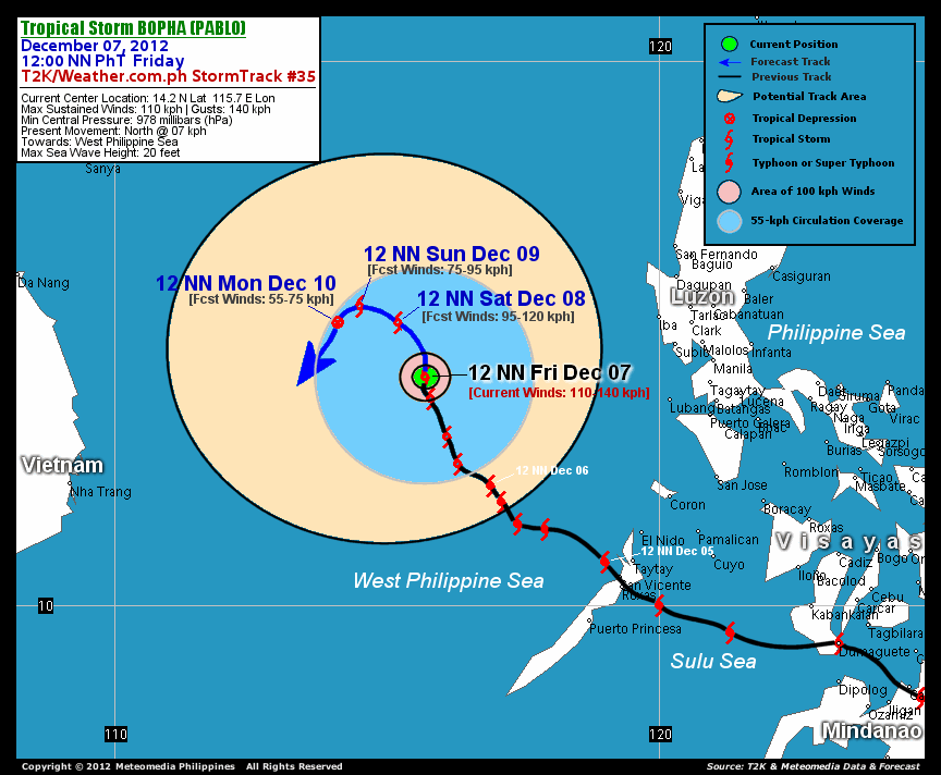
Issued: 12:00 NN PhT (04:00 GMT) Friday 07 Dec 2012
Next Update: 6:00 PM PhT (10:00 GMT) Friday 07 Dec 2012
Tropical Storm Bopha (Pablo) regained strength as it drifted slowly northward...circulation remains over the middle of the West Philippine Sea.
Residents and visitors along Palawan, Vietnam and Western Luzon should closely monitor the development of Bopha (Pablo).
Do not use this for life or death decision. This update is intended for additional information purposes only. Kindly refer to your national weather agency for official warnings, advisories or bulletins.
CURRENT STORM ANALYSIS
As of 12 noon today, the center of Tropical Storm Bopha was located over the West Philippine Sea...about 500 km west-southwest of Subic Bay or 583 km west of Metro Manila...currently moving north-northwest with a forward speed of 11 km/hr..
Maximum Sustained Winds (1-min. avg) have increased to 110 km/hr near the center with higher gusts. Tropical Storm Force Winds (62-117 km/hr) extend outward up to 110 kilometers from the center. Bopha remains an average-sized tropical cyclone with a diameter of 445 kilometers across. The 24-hour rainfall accumulation near the center of Tropical Storm Bopha is estimated to be exteme (450 mm).
3-DAY FORECAST OUTLOOK*
Tropical Storm Bopha is expected to turn slowly north-northwest to west-northwest for the next 36 hours...with a turn to the west and south through 72 hours. On the forecast track, the core of Bopha is expected to remain over the West Philippine Sea during the next 3 days and could move out of the Philippine Area of Responsibility (PAR) by late Saturday evening or Sunday morning.
Bopha will start to weaken and dissipate after 72 hours due to the effects of cooler dry air from the Northeast Monsoon and lower sea surface temperatures in the West Philippine Sea .
The following is the summary of the 3-day forecast outlook on this system:
SATURDAY NOON: Moving slowly across the West Philippine Sea...continues to weaken...about 515 km west of Iba, Zambales [12PM DEC 08: 15.2N 115.2E @ 95kph].
SUNDAY NOON: Decaying as it moves very slowly across the West Philippine Sea, exits the Philippine Area of Responsibility (PAR)...about 590 km west of Iba, Zambales [12PM DEC 09: 15.5N 115.5E @ 75kph].
MONDAY NOON: Weakens into a Tropical Depression...about 633 km west of Iba, Zambales [12PM DEC 10: 15.2N 114.1E @ 55kph].
*Please be reminded that the Forecast Outlook changes every 6 hours, and the Day 3 Forecast Track have an average error of 250 km...while the wind speed forecast error, averages 35 kph per day. Therefore, a turn to the left or right of its future track and changes in its wind speed must be anticipated from time to time.
EFFECTS & HAZARDS SUMMARY
Below is the summary of the storm's parts and its hazards affecting specific areas. You can also view this image link for you to understand the parts.
CENTRAL DENSE OVERCAST (CDO) - over water (West Philippine Sea). Near-Typhoon Conditions w/ Near-Typhoon Force Winds (110-140 kph) will be expected along the CDO (click here to know more about CDO).
INNER RAINBANDS - over water (West Philippine Sea)...not affecting any land areas. Tropical Storm Conditions with Tropical Storm Force Winds (62-117 kph) will be expected along these bands.
OUTER RAINBANDS - over water (West Philippine Sea)...not affecting any land areas. Tropical Depression Conditions with moderate to strong winds (<62 kph) will be expected along these bands (click here to know more about Rainbands).
24HR TOTAL RAINFALL ACCUMULATION - from 5 up to 200 mm (slight to heavy rainfall) can be expected along areas affected by the outer & inner rainbands (see above)...with isolated amounts of 201 to 450 mm (heavy to extreme) along areas near the center of Bopha.
Important Note: Please keep in mind that the above forecast outlook, effects and hazards summary changes every 6 to 12 hrs!
CURRENT TECHNICAL INFORMATION
Time/Date: 12:00 NN PhT Fri December 07, 2012
Class/Name: TS Bopha (Pablo)
Location of Center: 14.2º N Lat 115.7º E Lon
Distance 1: 478 km (WSW) from , Zambales
Distance 2: 487 km (WNW) from Lubang Island
Distance 3: 500 km (WSW) from Subic Bay
Distance 4: 583 km (W) from Metro Manila
MaxWinds (1-min avg): 110 kph near the center
Peak Wind Gusts: 140 kph
Present Movement: North @ 07 kph
Towards: West Philippine Sea
24hr Rainfall Accum (near center): Extreme [450 mm]
Minimum Central Pressure: 978 millibars (hPa)
Size (in Diameter): 445 km [Average]
Max Sea Wave Height (near center): 20 feet
Possible Storm Surge Height: 1-3 ft (0.3-0.9 m)

CURRENT NOAA/MTSAT-2 INFRARED SATELLITE IMAGE:

CURRENT TRACKING CHART:
_____________________________________________________________________________
>> To know the meteorological terminologies and acronyms used on this update visit the ff:
http://typhoon2000.ph/tcterm.htm
http://www.nhc.noaa.gov/aboutgloss.shtml
http://www.nhc.noaa.gov/acronyms.shtml
__________________________________________________________________________________________
For the complete details on TS BOPHA (PABLO)...go visit our website @:
> http://www.typhoon2000.com
> http://www.maybagyo.com
<<<Typhoon2000.com Mobile >>>
Get the latest SMS Storm Alerts!
For more details: Text T2K TYPHOON to
2800 (Globe/TM) | 216 (Smart/TNT) | 2288 (Sun)
*Only P2.50 (Smart/Globe) / P2.00 (Sun) per msg received.
Click here on how to use this service (in PDF file)
Powered by: Synermaxx Corporation
Copyright © 2012 Typhoon2000.com All Rights Reserved
| Reply via web post | Reply to sender | Reply to group | Start a New Topic | Messages in this topic (1) |

No comments:
Post a Comment