
WEATHER.COM.PH / T2K TROPICAL CYCLONE UPDATES
TYPHOON BOPHA (PABLO) UPDATE NUMBER 023
Issued: 7:00 PM PhT (11:00 GMT) Monday 03 Dec 2012
Next Update: 1:00 AM PhT (17:00 GMT) Tuesday 04 Dec 2012
Typhoon Bopha (Pablo) regained strength as it moves closer to Davao Oriental and Surigao Del Sur...continues to endanger Caraga Region. The possible landfall area is between Bislig and Hinatuan Area by tomorrow morning..
Important Note: Typhoon Bopha (Pablo) is almost three times the strength of Tropical Storm Washi (Sendong) which crossed North-Central Mindanao on December 16, 2011. Please take all precautionary measures on this dangerous cyclone. Refer to your national disaster agencies for more details.
Residents and visitors along Mindanao and Visayas should closely monitor the development of Bopha (Pablo).
Do not use this for life or death decision. This update is intended for additional information purposes only. Kindly refer to your national weather agency for official warnings, advisories or bulletins.
CURRENT STORM ANALYSIS
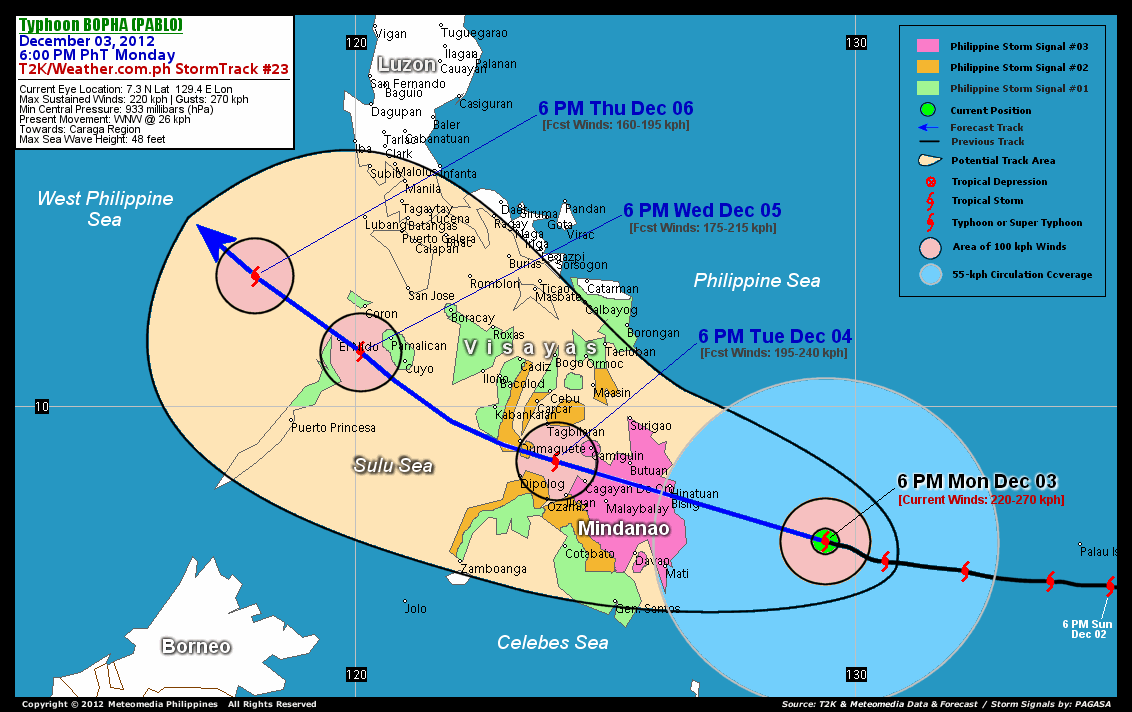
As of 6 pm today, the eye of Typhoon Bopha was located over the Philippine Sea...about 356 km east-southeast of Bislig City, Surigao Del Sur or 420 km east-northeast of Metro Davao...currently moving west-northwest with a forward speed of 26 km/hr in the general direction of Davao Oriental-Surigao Del Sur Area.
Maximum Sustained Winds (1-min. avg) have increased to 220 km/hr near the center with higher gusts. Typhoon Force Winds (118 km/hr or more) extend outward up to 55 kilometers from the center...and Tropical Storm Force Winds (62-117 km/hr) extend outward up to 185 kilometers. Bopha remains a large-sized tropical cyclone with a diameter of 775 kilometers across. The 24-hour rainfall accumulation near the center of Typhoon Bopha is estimated to be extreme (400 mm).
3-DAY FORECAST OUTLOOK*
Typhoon Bopha is expected to continue moving west-northwest for the next 24 to 36 hours with a slight decrease in its forward speed. After 36 hours, its track will turn to the northwest...and this motion will continue throughout the forecast period. On the forecast track, the core of Bopha is expected to make landfall in between Bislig and Hinatuan on Tuesday morning (approx. 6-7 am Manila Time)...and cross Surigao Del Sur, Agusan Del Sur and Misamis Oriental Tuesday morning until the afternoon, passing more or less 50 km north of Cagayan De Oro City between 4-5pm. By Tuesday evening, Bopha should emerge over the Bohol Sea and then traverse Southern Negros passing very close to Dumaguete City between 11 pm to 12 midnight. The typhoon will traverse Sulu Sea Wednesday morning...passing close to Cuyo and Pamalican Islands late Wednesday afternoon...and over or very close to El Nido, Palawan by late Wednesday evening.
Bopha will still slightly gain strength prior in making landfall and could regain Super Typhoon status tonight. It will then weaken throughout the forecast period due to its passage across the landmass of Mindanao and the Visayas.
The following is the summary of the 3-day forecast outlook on this system:
 TUESDAY EVENING: Over Bohol Sea as it weakens to Category 3...about 80 km northwest of Cagayan De Oro [6PM DEC 04: 8.9N 124.0E @ 195kph].
WEDNESDAY EVENING: Over the shores of Northern Palawan as it weakens to Category 2...about 49 km southeast of El Nido, Northern Palawan [6PM DEC 05: 11.1N 120.1E @ 175kph].
THURSDAY EVENING: Maintains its strength as it moves slowly northwestward across the West Philippine Sea...about 248 km west-northwest of Coron, Northern Palawan [6PM DEC 06: 12.6N 118.0E @ 160kph].
*Please be reminded that the Forecast Outlook changes every 6 hours, and the Day 3 Forecast Track have an average error of 250 km...while the wind speed forecast error, averages 35 kph per day. Therefore, a turn to the left or right of its future track and changes in its wind speed must be anticipated from time to time.
EFFECTS & HAZARDS SUMMARY
Below is the summary of the storm's parts and its hazards affecting specific areas. You can also view this image link for you to understand the parts.
RAGGED EYE - over water (Philippine Sea) Possible calm and lull conditions (with <20 kph winds) will be expected inside the eye (click here to know more about the EYE). EYEWALL - over water (Philippine Sea)...not yet affecting any land areas....but the western part of the eyewall will reach the coast of Surigao Del Sur before sunrise Tuesday. Typhoon Conditions with Typhoon Force Winds (>118 kph) will be expected within this wall (click here to know more about the Eyewall). INNER RAINBANDS - over water (Philippine Sea)...not affecting any land areas...but will reach Caraga Region and Davao Oriental tonight. Tropical Storm Conditions with Tropical Storm Force Winds (62-117 kph) will be expected along these bands. OUTER RAINBANDS - affecting and spreading across Caraga Region and Davao Oriental. Tropical Depression Conditions with moderate to strong winds (<62 kph) will be expected along these bands (click here to know more about Rainbands). 24HR TOTAL RAINFALL ACCUMULATION - from 5 up to 200 mm (slight to heavy rainfall) can be expected along areas affected by the outer & inner rainbands (see above)...with isolated amounts of 201 to 400 mm (heavy to extreme) along areas near the center of Bopha. COASTAL STORM SURGE FLOODING - possible 13-18 ft (4-5.5 m) above normal tide levels...accompanied by large and dangerous battering waves can be expected along the coastal, inland lakes and beach front areas of Caraga Region and Davao Oriental beginning tonight. Extreme damage is likely on this type of storm surge. Danger from Rip Currents or Rip Tides can be expected along the rest of the beach-front areas of Western Micronesia, Rest of Mindanao and the Visayas (click here to know more about Storm Surge).
Important Note: Please keep in mind that the above forecast outlook, effects and hazards summary changes every 6 to 12 hrs!
CURRENT TECHNICAL INFORMATION
Time/Date: 6:00 PM PhT Mon December 03, 2012
Class/Name: TY Bopha (Pablo)
Location of Eye: 7.3º N Lat 129.4º E Lon
Distance 1: 356 km (ESE) from Bislig City
Distance 2: 357 km (ENE) from Mati City
Distance 3: 420 km (ESE) from Metro Davao
Distance 4: 465 km (ESE) from Butuan City
Distance 5: 477 km (SE) from Siargao Island
Distance 6: 493 km (ESE) from Malaybalay City
Distance 7: 511 km (SE) from Surigao City
Distance 8: 545 km (ESE) from Cagayan De Oro City
Distance 9: 559 km (ESE) from Camiguin Island
Distance 10: 582 km (ESE) from Iligan City
Distance 11: 667 km (SE) from Tagbilaran City
Distance 12: 690 km (SE) from Metro Cebu
MaxWinds (1-min avg): 220 kph near the center
Peak Wind Gusts: 270 kph
Saffir-Simpson Hurricane Scale: Category 4
Present Movement: WNW @ 28 kph
Towards: Davao Oriental-Surigao Del Sur Area
CPA [ETA] to Surigao Del Sur: Tue Morning [6-7AM PhT]
24hr Rainfall Accum (near center): Extreme [400 mm]
Minimum Central Pressure: 933 millibars (hPa)
Size (in Diameter): 775 km [Large]
Max Sea Wave Height (near center): 48 feet
Possible Storm Surge Height: 13-18 ft (4-5.5 m)
T2K/WP StormTracks (for Public): GIF | Google Map (Flash)

CURRENT NOAA/MTSAT-2 INFRARED SATELLITE IMAGE:

CURRENT TRACKING CHART:
_____________________________________________________________________________
>> To know the meteorological terminologies and acronyms used on this update visit the ff:
http://typhoon2000.ph/tcterm.htm
http://www.nhc.noaa.gov/aboutgloss.shtml
http://www.nhc.noaa.gov/acronyms.shtml
__________________________________________________________________________________________
For the complete details on TY BOPHA (PABLO)...go visit our website @:
> http://www.typhoon2000.com
> http://www.maybagyo.com
<<<Typhoon2000.com Mobile >>>
Get the latest SMS Storm Alerts!
For more details: Text T2K TYPHOON to
2800 (Globe/TM) | 216 (Smart/TNT) | 2288 (Sun)
*Only P2.50 (Smart/Globe) / P2.00 (Sun) per msg received.
Click here on how to use this service (in PDF file)
Powered by: Synermaxx Corporation
Copyright © 2012 Typhoon2000.com All Rights Reserved
| Reply via web post | Reply to sender | Reply to group | Start a New Topic | Messages in this topic (1) |

No comments:
Post a Comment