
WEATHER.COM.PH / T2K TROPICAL CYCLONE UPDATES
SUPER TYPHOON BOPHA (PABLO) UPDATE NUMBER 020
Issued: 7:00 PM PhT (10:00 GMT) Sunday 02 Dec 2012
Next Update: 7:00 AM PhT (23:00 GMT) Monday 03 Dec 2012
Super Typhoon Bopha (Pablo) is now entering the Philippine Area of Responsibility (PAR) as it strengthened to a 250-km/hr howler. Its small eye is expected to pass near to the south of Koror within the next few hours...with the northern eyewall passing over Southern Palau.
Important Note: This howler is similar in strength and track of Super Typhoon Mike (Ruping) which passed over Palau in November 1990. Please take all precautionary measures on this extremely dangerous cyclone. Refer to your national disaster agencies for more details.
Residents and visitors along Western Micronesia and the Philippines (particularly the Republic of Palau, Mindanao, Visayas and Bicol Region) should closely monitor the development of Bopha (Pablo).
Do not use this for life or death decision. This update is intended for additional information purposes only. Kindly refer to your national weather agency for official warnings, advisories or bulletins.
CURRENT STORM ANALYSIS
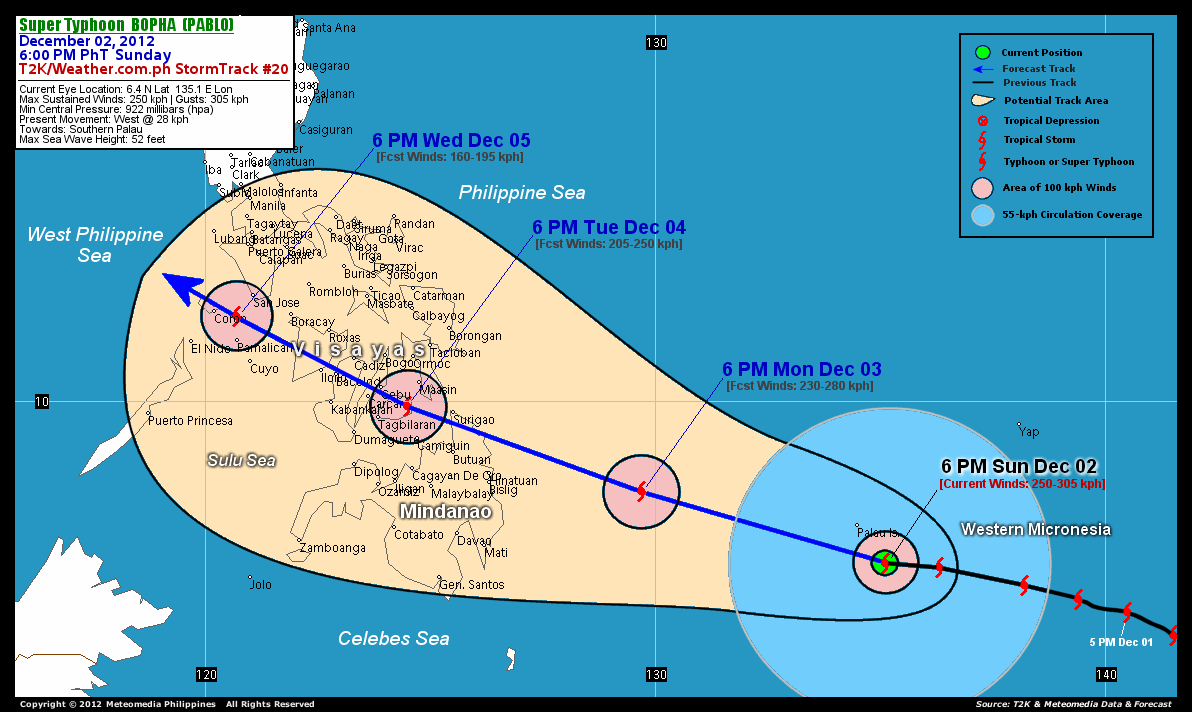
As of 6 pm today, the small eye of Super Typhoon Bopha was located over Western Micronesia...about 105 km south-southeast of Koror, Palau or 1,087 km east-southeast of Siargao Island, Surigao Del Norte...currently moving faster westerly with a forward speed of 28 km/hr in the general direction of Southern Palau and Philippine Sea.
Maximum Sustained Winds (1-min. avg) have increased to 250 km/hr near the center with higher gusts. Typhoon Force Winds (118 km/hr or more) extend outward up to 55 kilometers from the center...and Tropical Storm Force Winds (62-117 km/hr) extend outward up to 230 kilometers. Bopha is a large-sized tropical cyclone with a diameter of 775 kilometers across. The 24-hour rainfall accumulation near the center of Typhoon Bopha is estimated to be heavy (300 mm).
3-DAY FORECAST OUTLOOK*
Super Typhoon Bopha is expected to resume its west-northwest track for the next 24 to 48 hours with a decrease in its forward speed...and this motion will continue throughout the forecast period. On the forecast track, the core of Bopha is expected to pass over or very close to Southern Palau (approx. 75 km South of Koror) this evening between 9:00-10:00 pm Manila Time...and should make landfall over Surigao Del Norte on Tuesday morning (passing very close to Surigao City before noontime). Bopha may start to traverse Central Visayas Tuesday evening, passing over Bohol and crossing Central Cebu before midnight of Wednesday. On Wednesday early morning, the typhoon should traverse Central Negros passing over or very close to Bacolod City before sunrise...over Guimaras-Iloilo City after sunrise...and approaching Coron, Palawan on Wednesday evening.
Bopha may start to slowly weaken during the next 12 to 24 hours...and could be downgraded due to lower Ocean Heat Content (OHC) or slightly cooler sea-surface temperatures along the Philippine Sea. Further weakening is anticipated once the system moves across Northern Mindanao and the Visayas due to the effects of land interaction.
The following is the summary of the 3-day forecast outlook on this system:
 MONDAY EVENING: Starts to weaken as it moves across the Philippine Sea, farther away from the Republic of Palau towards Surigao Provinces...about 375 km east of Bislig City, Surigao Del Sur [6PM DEC 03: 8.0N 129.7E @ 230kph].
TUESDAY EVENING: Over Eastern Bohol, approaching Cebu...about 79 km southeast of Metro Cebu...weakens to a Category 3 Typhoon [6PM DEC 04: 9.9N 124.5E @ 205kph].
WEDNESDAY EVENING: Weakens to a Category 2 Typhoon as it approaches Coron, Palawan...about 56 km north of Amanpulo, Pamalican Island [6PM DEC 05: 11.9N 120.7E @ 160kph].
*Please be reminded that the Forecast Outlook changes every 6 hours, and the Day 3 Forecast Track have an average error of 250 km...while the wind speed forecast error, averages 35 kph per day. Therefore, a turn to the left or right of its future track and changes in its wind speed must be anticipated from time to time.
EFFECTS & HAZARDS SUMMARY
Below is the summary of the storm's parts and its hazards affecting specific areas. You can also view this image link for you to understand the parts.
17-KM. CLOUD-FILLED EYE - over water (Western Micronesia)...but will pass along the Southernmost part of Palau. Possible calm and lull conditions (with <20 kph winds) will be expected inside the eye (click here to know more about the EYE). EYEWALL - affecting Southern Palau tonight. Typhoon Conditions with Typhoon Force Winds (>118 kph) will be expected within this wall (click here to know more about the Eyewall). INNER RAINBANDS - affecting and spreading across the smaller islands of Western Micronesia and the rest of Palau. Tropical Storm Conditions with Tropical Storm Force Winds (62-117 kph) will be expected along these bands. OUTER RAINBANDS - affecting and spreading across Yap and Ulithi Islands and other smaller islands of Western and Central Micronesia. Tropical Depression Conditions with moderate to strong winds (<62 kph) will be expected along these bands (click here to know more about Rainbands). 24HR TOTAL RAINFALL ACCUMULATION - from 5 up to 200 mm (slight to heavy rainfall) can be expected along areas affected by the outer & inner rainbands (see above)...with isolated amounts of 201 to 300 mm (heavy) along areas near the center of Bopha. COASTAL STORM SURGE FLOODING - possible 13-18 ft (4-5.5 m) above normal tide levels...accompanied by large and dangerous battering waves can be expected along the coastal, inland lakes and beach front areas of the Republic of Palau. Extreme damage is likely on this type of storm surge. Danger from Rip Currents or Rip Tides can be expected along the rest of the beach-front areas of Western Micronesia, Eastern Mindanao and the Marianas (click here to know more about Storm Surge).
Important Note: Please keep in mind that the above forecast outlook, effects and hazards summary changes every 6 to 12 hrs!
CURRENT TECHNICAL INFORMATION
Time/Date: 6:00 PM PhT Sun December 02, 2012
Class/Name: STY Bopha (26W)
Location of Eye: 6.4º N Lat 135.0º E Lon
Distance 1: 0 km (E) from the PAR
Distance 2: 105 km (SSE) from Koror, Palau
Distance 3: 973 km (E) from Mati City
Distance 4: 980 km (ESE) from Bislig City
Distance 5: 1,094 km (ESE) from Butuan City
Distance 6: 1,087 km (ESE) from Siargao Island
Distance 7: 1,122 km (ESE) from Surigao City
Distance 8: 1,187 km (ESE) from Camiguin Island
Distance 9: 1,212 km (SE) from Borongan City
Distance 10: 1,227 km (SE) from Maasin City
Distance 11: 1,231 km (SE) from Tacloban City
Distance 12: 1,306 km (ESE) from Metro Cebu
MaxWinds (1-min avg): 250 kph near the center
Peak Wind Gusts: 305 kph
Saffir-Simpson Hurricane Scale: Category 4
Present Movement: West @ 28 kph
Towards: Southern Palau
24hr Rainfall Accum (near center): Heavy [300 mm]
Minimum Central Pressure: 922 millibars (hPa)
Size (in Diameter): 775 km [Large]
Max Sea Wave Height (near center): 52 feet
Possible Storm Surge Height: 13-18 ft (4-5.5 m)
T2K/WP StormTracks (for Public): GIF | Google Map (Flash)

CURRENT NOAA/MTSAT-2 INFRARED RB-TOP SATELLITE IMAGE:

CURRENT TRACKING CHART:
_____________________________________________________________________________
>> To know the meteorological terminologies and acronyms used on this update visit the ff:
http://typhoon2000.ph/tcterm.htm
http://www.nhc.noaa.gov/aboutgloss.shtml
http://www.nhc.noaa.gov/acronyms.shtml
__________________________________________________________________________________________
For the complete details on STY BOPHA (PABLO)...go visit our website @:
> http://www.typhoon2000.com
> http://www.maybagyo.com
<<<Typhoon2000.com Mobile >>>
Get the latest SMS Storm Alerts!
For more details: Text T2K TYPHOON to
2800 (Globe/TM) | 216 (Smart/TNT) | 2288 (Sun)
*Only P2.50 (Smart/Globe) / P2.00 (Sun) per msg received.
Click here on how to use this service (in PDF file)
Powered by: Synermaxx Corporation
Copyright © 2012 Typhoon2000.com All Rights Reserved
| Reply via web post | Reply to sender | Reply to group | Start a New Topic | Messages in this topic (1) |

No comments:
Post a Comment