
WEATHER.COM.PH / T2K TROPICAL CYCLONE UPDATES
TROPICAL STORM PRAPIROON (NINA) UPDATE NUMBER 028
Issued: 7:00 PM PhT (11:00 GMT) Wednesday 17 Oct 2012
Next Update: 7:00 AM PhT (22:00 GMT) Thursday 18 Oct 2012
The decaying Tropical Storm Prapiroon (Nina) has turned north-northeastward closer to Okinawa and the Ryukyus. Stormy conditions now occurring across these islands...expected to leave the Philippine Area of Responsibility (PAR) later tonight.
Meanwhile, Tropical Storm Maria (23W) has started to speed up away from Chichi Jima, across the Northwest Pacific Ocean. Its center was located about 500 km northeast of Chichi Jima...with winds of 95 km/hr...moving east-northeast at 24 kph. Maria is forecast to continue moving across the sea to the southeast of Japan on Thursday through Friday.
Residents and visitors along Okinawa and Southern Japan should closely monitor the development of Prapiroon (Nina).
Do not use this for life or death decision. This update is intended for additional information purposes only. Kindly refer to your national weather agency for official warnings, advisories or bulletins.
CURRENT STORM ANALYSIS
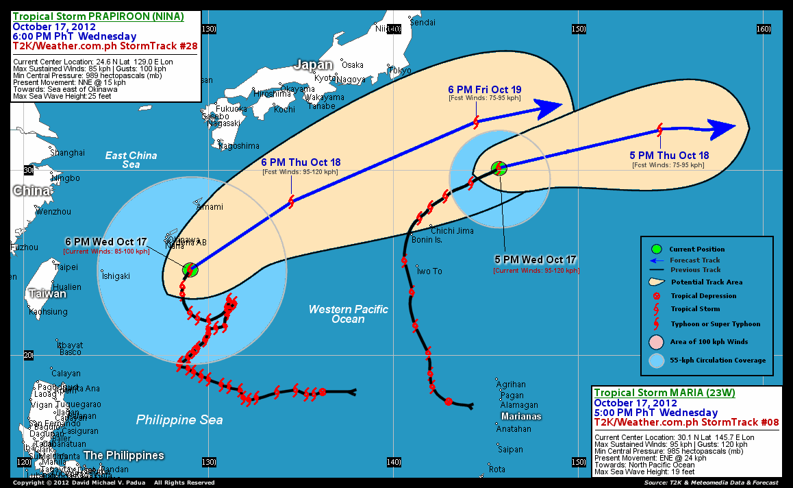
As of 6 pm today, the center of Tropical Storm Prapiroon (Nina) was located over the open waters of the North Philippine Sea...about 850 km northeast of Basco, Batanes or 221 km southeast of Naha International Airport, Okinawa...currently moving north-northeast with a forward speed of 15 km/hr.
Maximum Sustained Winds (1-min. avg) have decreased to 85 km/hr near the center with higher gusts. Tropical Storm Force Winds (62-117 km/hr) extend outward up to 290 kilometers from the center. Areas around Okinawa are now starting to feel tropical storm force winds and will persist until early Thursday. Prapiroon (Nina) is a very large-sized tropical cyclone with a diameter of 1,110 kilometers across. The 24-hour rainfall accumulation near and south of the center of Prapiroon (Nina) is estimated to be moderate to heavy (120 mm).
2-DAY FORECAST OUTLOOK*
Tropical Storm Prapiroon (Nina) is expected to turn more northeasterly during the next 24 hours...moving faster to the east-northeast through 48 hours. On the forecast track, the core of Prapiroon (Nina) will move out of the Philippine Area of Responsibility (PAR) later tonight, as it passes just to the east-southeast of Okinawa. This storm may then start to accelerate at a faster speed towards the sea south of Japan on Thursday through Saturday.
Some fluctuations on the strength of this storm is likely during the next 24 hours before it starts to decay. The decay of Prapiroon (Nina) in the next couple of days is due to its movement across cooler sea surface temperatures (lower heat content) and unfavorable atmospheric conditions.
The following is the summary of the 2-day forecast outlook on this system:
 THURSDAY EVENING: Accelerating rapidly east-northeastward while passing to the sea south of Japan...intensifies slightly...about 606 km south-southwest of Tanabe, Japan [6PM OCT 18: 28.3N 134.5E @ 95kph].
FRIDAY EVENING: Still on a rapid east-northeasterly track across the Northwest Pacific Ocean...weakens over cooler ocean temperatures...about 560 km southeast of Tokyo, Japan [6PM OCT 19: 32.6N 144.5E @ 75kph].
*Please be reminded that the Forecast Outlook changes every 6 hours, and the Day 3 Forecast Track have an average error of 250 km...while the wind speed forecast error, averages 35 kph per day. Therefore, a turn to the left or right of its future track and changes in its wind speed must be anticipated from time to time.
EFFECTS & HAZARDS SUMMARY
Below is the summary of the storm's parts and its hazards affecting specific areas. You can also view this image link for you to understand the parts.
INNER RAINBANDS - affecting and spreading across Okinawa, Amami and the rest of the Ryukyus. Tropical Storm Conditions with Tropical Storm Force Winds (62-117 kph) will be expected along these bands. OUTER RAINBANDS - affecting and spreading across Ishigaki and Yaeyama Islands. Tropical Depression Conditions with moderate to strong winds (<62 kph) will be expected along these bands (click here to know more about Rainbands). 24HR TOTAL RAINFALL ACCUMULATION - from 5 up to 50 mm (light to moderate rainfall) can be expected along areas affected by the outer & inner rainbands (see above)...with isolated amounts of 51 to 120 mm (moderate to heavy) along areas near and south of the center of Prapiroon (Nina).
Important Note: Please keep in mind that the above forecast outlook, effects and hazards summary changes every 6 to 12 hrs!
CURRENT TECHNICAL INFORMATION
Time/Date: 6:00 PM PhT Wed October 17, 2012
Class/Name: TS Prapiroon (Nina)
Location of Center: 24.6º N Lat 129.0º E Lon
Distance 1: 221 km (SE) closer to Naha Airport, Okinawa
Distance 2: 239 km (SE) closer to Kadena Air Base, Okinawa
Distance 3: 243 km (SSE) closer to Okinawa City
Distance 4: 413 km (S) closer to Amami Is., Ryukyus
Distance 5: 850 km (NE) away from Basco, Batanes
MaxWinds (1-min avg): 85 kph near the center
Peak Wind Gusts: 100 kph
Present Movement: NNE @ 15 kph
Towards: Sea East of Okinawa
24hr Rainfall Accum (near center): Mod-Heavy [120 mm]
Minimum Central Pressure: 989 millibars (hPa)
Size (in Diameter): 1,110 km [Very Large]
Max Sea Wave Height (near center): 25 feet
Possible Storm Surge Height: 1-3 ft (0.3-0.9 m)
T2K StormTracks (for Public): GIF | Google Map (Flash)

CURRENT NOAA/MTSAT-2 INFRARED SATELLITE IMAGE:

CURRENT TRACKING CHART:
_____________________________________________________________________________
>> To know the meteorological terminologies and acronyms used on this update visit the ff:
http://typhoon2000.ph/tcterm.htm
http://www.nhc.noaa.gov/aboutgloss.shtml
http://www.nhc.noaa.gov/acronyms.shtml
__________________________________________________________________________________________
For the complete details on TS PRAPIROON (NINA)...go visit our website @:
> http://www.typhoon2000.com
> http://www.maybagyo.com
<<<Typhoon2000.com Mobile >>>
Get the latest SMS Storm Alerts!
For more details: Text T2K TYPHOON to
2800 (Globe/TM) | 216 (Smart/TNT) | 2288 (Sun)
*Only P2.50 (Smart/Globe) / P2.00 (Sun) per msg received.
Click here on how to use this service (in PDF file)
Powered by: Synermaxx Corporation
Copyright © 2012 Typhoon2000.com All Rights Reserved
| Reply via web post | Reply to sender | Reply to group | Start a New Topic | Messages in this topic (1) |

No comments:
Post a Comment