
WEATHER.COM.PH / T2K TROPICAL CYCLONE UPDATES
TROPICAL STORM SON-TINH (OFEL) UPDATE NUMBER 007
Issued: 7:00 PM PhT (11:00 GMT) Thursday 25 Oct 2012
Next Update: 7:00 AM PhT (23:00 GMT) Friday 26 Oct 2012
Tropical Storm Son-Tinh (Ofel) continues to move fast across the West Philippine Sea, farther away from the Philippines.
Meanwhile, this system will continue to enhance the Northeast Monsoon (Amihan) and bring on-and-off rains, squalls, thunderstorms across Extreme Northern Luzon. Winds will be moderate to strong not in excess of 40 km/hr. The sea waves along the coast will be rough and dangerous (8-12 feet).
Residents and visitors along Central Vietnam and Hainan Island should closely monitor the development of Son-Tinh (Ofel).
Do not use this for life or death decision. This update is intended for additional information purposes only. Kindly refer to your national weather agency for official warnings, advisories or bulletins.
CURRENT STORM ANALYSIS
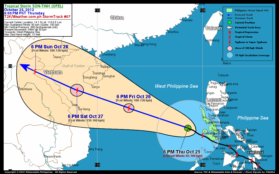
As of 6 pm today, the center of Tropical Storm Son-Tinh (Ofel) was located over the West Philippine Sea...about 199 km west-southwest of Subic Bay, Zambales or 275 km west-southwest of Metro Manila...currently moving west-northwest with a forward speed of 30 km/hr in the general direction of the West Philippine and South China Seas.
Maximum Sustained Winds (1-min. avg) remain at 85 km/hr near the center with higher gusts. Tropical Storm Force Winds (62-100 km/hr) extend outward up to 85 kilometers from the center. Son-Tinh (Ofel) is a large-sized tropical cyclone with a diameter of 780 kilometers across. The 24-hour rainfall accumulation near the center of Son-Tinh (Ofel) is estimated to be heavy (150 mm).
3-DAY FORECAST OUTLOOK*
Tropical Storm Son-Tinh (Ofel) is expected to continue moving west-northwestward during the next 12 to 24 hours with a decrease in its forward speed. It will therefore maintain its track throughout the forecast period. On the forecast track, the core of Son-Tinh (Ofel) is expected to continue moving across the West Philippine Sea tonight...exiting the Philippine Area of Responsibility (PAR) on Friday morning. The storm should then pass just south of Hainan Island on Saturday afternoon...and make landfall along the shores of North-Central Vietnam on Sunday.
This storm is expected to slowly intensify during the next 2 days, while over the West Philippine and South China Seas...and Son-Tinh (Ofel) could become a Typhoon on Saturday.
The following is the summary of the 3-day forecast outlook on this system:
 FRIDAY EVENING: Continuing moving west-northwest across the West Philippine Sea...exits the Philippine Area of Responsibility (PAR)...about 513 km east of Da Nang, Vietnam [6PM OCT 26: 16.0N 113.0E @ 100kph].
SATURDAY EVENING: Becomes a Typhoon as it passes south of Hainan Island, prepares to make landfall over North-Central Vietnam...about 144 km north of Hue, Vietnam [6PM OCT 27: 17.7N 108.1E @ 130kph].
SUNDAY EVENING: Makes landfall over North-Central Vietnam...just along the Laos-Vietnam Border...weakens to a Tropical Storm...about 243 km southwest of Hanoi, Vietnam [6PM OCT 28: 19.5N 104.1E @ 100kph].
*Please be reminded that the Forecast Outlook changes every 6 hours, and the Day 3 Forecast Track have an average error of 250 km...while the wind speed forecast error, averages 35 kph per day. Therefore, a turn to the left or right of its future track and changes in its wind speed must be anticipated from time to time.
EFFECTS & HAZARDS SUMMARY
Below is the summary of the storm's parts and its hazards affecting specific areas. You can also view this image link for you to understand the parts.
INNER RAINBANDS - affecting and spreading across Lubang Island and Calamian Group of Islands. Tropical Storm Conditions with Tropical Storm Force Winds (62-85 kph) will be expected along these bands. OUTER RAINBANDS - affecting and spreading across Metro Manila, Rest of Luzon, Mindoro, Northern Palawan, Western Visayas, Masbate, Romblon, and Boracay. Tropical Depression Conditions with moderate to strong winds (<62 kph) will be expected along these bands (click here to know more about Rainbands). 24HR TOTAL RAINFALL ACCUMULATION - from 5 up to 100 mm (light to heavy rainfall) can be expected along areas affected by the outer & inner rainbands (see above)...with isolated amounts of 101 to 150 mm (heavy) along areas near the center of Son-Tinh (Ofel). COASTAL STORM SURGE FLOODING - possible 1-3 ft (0.3-0.9 m) above normal tide levels...accompanied by large and dangerous battering waves can be expected along the coastal, inland lakes and beach front areas of Western Mindoro and Lubang Island. Very minimal damage is likely on this type of storm surge. Danger from Rip Currents or Rip Tides can be expected along the rest of the beach-front areas of Luzon, Palawan and the Visayas (click here to know more about Storm Surge).
Important Note: Please keep in mind that the above forecast outlook, effects and hazards summary changes every 6 to 12 hrs!
CURRENT TECHNICAL INFORMATION
Time/Date: 6:00 PM PhT Thu October 25, 2012
Class/Name: TS Son-Tinh (Ofel)
Location of Center: 14.1� N Lat 118.6� E Lon
Distance 1: 176 km (WNW) away from Lubang Island
Distance 2: 199 km (WSW) away from Subic Bay
Distance 3: 201 km (SW) away from Iba, Zambales
Distance 4: 275 km (WSW) away from Metro Manila
Distance 5: 248 km (W) away from Tagaytay City
Distance 6: 257 km (WNW) away from Puerto Galera
Distance 7: 261 km (WNW) away from Batangas City
Distance 8: 279 km (SSW) away from Dagupan City
Distance 9: 291 km (NW) away from Coron, Palawan
Distance 10: 1,138 km (ESE) closer to Da Nang, Vietnam
MaxWinds (1-min avg): 85 kph near the center
Peak Wind Gusts: 100 kph
Present Movement: WNW @ 30 kph
Towards: West Philippine Sea
24hr Rainfall Accum (near center): Heavy [150 mm]
Minimum Central Pressure: 989 millibars (hPa)
Size (in Diameter): 780 km [Large]
Max Sea Wave Height (near center): 15 feet
Possible Storm Surge Height: 1-3 ft (0.3-0.9 m)
T2K StormTracks (for Public): GIF | Google Map (Flash)

CURRENT NOAA/MTSAT-2 INFRARED SATELLITE IMAGE:

CURRENT TRACKING CHART:
_____________________________________________________________________________
>> To know the meteorological terminologies and acronyms used on this update visit the ff:
http://typhoon2000.ph/tcterm.htm
http://www.nhc.noaa.gov/aboutgloss.shtml
http://www.nhc.noaa.gov/acronyms.shtml
__________________________________________________________________________________________
For the complete details on TS SON-TINH (OFEL)...go visit our website @:
> http://www.typhoon2000.com
> http://www.maybagyo.com
<<<Typhoon2000.com Mobile >>>
Get the latest SMS Storm Alerts!
For more details: Text T2K TYPHOON to
2800 (Globe/TM) | 216 (Smart/TNT) | 2288 (Sun)
*Only P2.50 (Smart/Globe) / P2.00 (Sun) per msg received.
Click here on how to use this service (in PDF file)
Powered by: Synermaxx Corporation
Copyright © 2012 Typhoon2000.com All Rights Reserved
| Reply via web post | Reply to sender | Reply to group | Start a New Topic | Messages in this topic (1) |

No comments:
Post a Comment