
WEATHER.COM.PH / T2K TROPICAL CYCLONE UPDATES
TROPICAL DEPRESSION GAEMI (MARCE) UPDATE NUMBER 015 [FINAL]
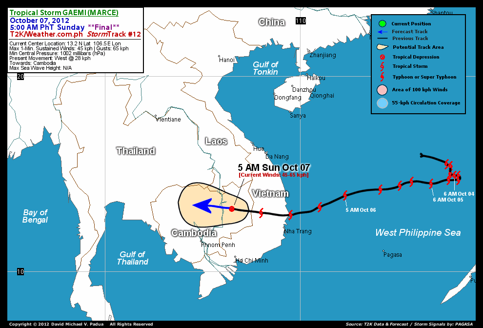
Issued: 5:00 AM PhT (21:00 GMT) Sunday 07 Oct 2012
GAEMI (MARCE) rapidly dissipating over Cambodia...just a weak Tropical Depression. This system has made landfall over Southeastern Vietnam, just north of Nha Trang City around sunset yesterday.
This is the last and final update on Gaemi (Marce).
Do not use this for life or death decision. This update is intended for additional information purposes only. Kindly refer to your national weather agency for official warnings, advisories or bulletins.
CURRENT STORM ANALYSIS
As of 5 am today, the center of Tropical Depression Gaemi (Marce) was located over Cambodia...about 256 km northeast of Phnom Penh City and is currently moving westward with a forward speed of 28 kph in the general direction of Central Cambodia.
Maximum Sustained Winds (1-min. avg) have decreased to 45 km/hr near the center with higher gusts. Gaemi (Marce) is an average-sized tropical cyclone with a diameter of 500 kilometers across. The 24-hour rainfall accumulation near the center of Gaeme (Marce) is estimated to be heavy (350 mm).
EFFECTS & HAZARDS SUMMARY
Below is the summary of the storm's parts and its hazards affecting specific areas. You can also view this image link for you to understand the parts.
 DECAYING RAINBANDS - affecting and spreading across Cambodia. Cloudy/Rainy Conditions with moderate to strong winds (<62 kph) will be expected along these bands (click here to know more about Rainbands). 24HR TOTAL RAINFALL ACCUMULATION - from 5 up to 200 mm (low to heavy rainfall) can be expected along areas affected by the outer & inner rainbands (see above)...with isolated amounts of 201 to 350 mm (heavy) along areas near the center of Gaemi (Marce).
Important Note: Please keep in mind that the above forecast outlook, effects-hazards, current monsoon intensity, & tropical cyclone watch changes every 6 to 12 hrs!
CURRENT TECHNICAL INFORMATION
Time/Date: 5:00 AM PhT Sat October 06, 2012
Class/Name: Tropical Depression Gaemi (Marce)
Location of Center: 13.2º N Lat 106.5º E Lon
Distance 1: 256 km (NE) away from Phnom Penh, Cambodia
Distance 2: 267 km (NNW) away from Ho Chi Minh City
Distance 3: 300 km (WNW) away from Nha Trang, Vietnam
Distance 4: 365 km (SSW) away from Da Nang, Vietnam
Distance 5: 382 km (SSW) away from Hue, Vietnam
MaxWinds (1-min avg): 45 kph near the center
Peak Wind Gusts: 65 kph
Present Movement: West @ 28 kph
Towards: Cambodia
24hr Rainfall Accum (near center): Heavy [350 mm]
Minimum Central Pressure: 1002 millibars (hPa)
Size (in Diameter): 500 km [Average]
Max Sea Wave Height (near center): N/A
Possible Coastal Storm Surge Height: 0 ft (0 m)
T2K StormTracks (for Public): Google Map (Flash) | GIF

CURRENT NOAA/MTSAT-2 INFRARED (IR) SATELLITE IMAGE:

CURRENT TRACKING MAP:
 _____________________________________________________________________________
>> To know the meteorological terminologies and acronyms used on this update visit the ff:
http://typhoon2000.ph/tcterm.htm
http://www.nhc.noaa.gov/aboutgloss.shtml
http://www.nhc.noaa.gov/acronyms.shtml
__________________________________________________________________________________________
For the complete final details on TD GAEMI (MARCE)...go visit our website @:
> http://www.typhoon2000.com
> http://www.maybagyo.com
<<<Typhoon2000.com Mobile >>>
Get the latest SMS Storm Alerts!
For more details: Text T2K TYPHOON to
2800 (Globe/TM) | 216 (Smart/TNT) | 2288 (Sun)
*Only P2.50 (Smart/Globe) / P2.00 (Sun) per msg received.
Click here on how to use this service (in PDF file)
Powered by: Synermaxx Corporation
Copyright © 2012 Typhoon2000.com All Rights Reserved
| Reply via web post | Reply to sender | Reply to group | Start a New Topic | Messages in this topic (1) |

No comments:
Post a Comment