
WEATHER.COM.PH / T2K TROPICAL CYCLONE UPDATES
TROPICAL STORM PRAPIROON (22W) UPDATE NUMBER 001
Issued: 6:00 AM PhT (22:00 GMT) Monday 08 Oct 2012
Next Update: 12:00 NN PhT (04:00 GMT) Monday 08 Oct 2012
The strong disturbance off the Western Pacific has developed into a Tropical Depression last night, and eventually into Tropical Storm PRAPIROON. This newly-formed cyclone is located far away at sea. The dynamic forecast models are showing it to remain over the North Philippine Sea as it slowly strengthens. Prapiroon is a Thai word for their God of Rain.
Residents and visitors along Extreme Northern Luzon, Taiwan and Okinawa should closely monitor the development of Prapiroon.
Do not use this for life or death decision. This update is intended for additional information purposes only. Kindly refer to your national weather agency for official warnings, advisories or bulletins.
CURRENT STORM ANALYSIS
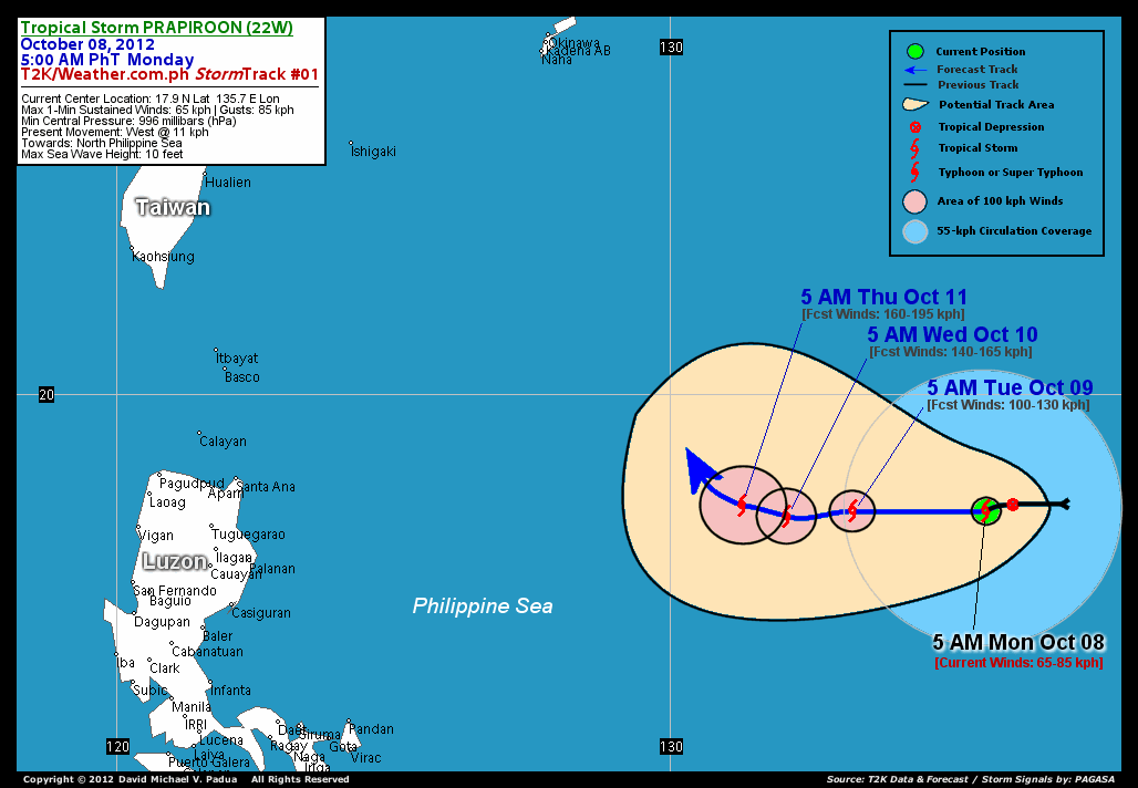
As of 5 am today, the center of Tropical Storm Prapiroon (22W) was located over the open sea of the Western Pacific, near the northeastern boundary of the Philippine Area of Responsibility (PAR)...about 1095 km west-northwest of Guam or 1428 km east of Cagayan, Philippines and is currently moving westward slowly with a forward speed of 11 kph.
Maximum Sustained Winds (1-min. avg) are at 65 km/hr near the center with higher gusts. Prapiroon (22W) is an average-sized tropical cyclone with a diameter of 610 kilometers across. The 24-hour rainfall accumulation near the center of Prapiroon (22W) is estimated to be heavy (200 mm).
3-DAY FORECAST OUTLOOK*
Prapiroon (22W) is expected to continue moving on a slow westward track during the next 2 days with a slight west-northwest turn by Day 3. On the forecast track, the center of Prapiroon (22W) will remain over the open sea through Thursday.
Continued strengthening of its wind speed is expected as the system moves over warm sea surface temperatures...and Prapiroon (22W) could become a minimal typhoon by late Tuesday.
The following is the summary of the 3-day forecast outlook on this system:
 TUESDAY MORNING: Moving very slowly westward across the North Philippine Sea...about 1174 km east of Cagayan, PH [5AM OCT 09: 17.9N 133.3E @ 100kph].
WEDNESDAY MORNING: Becomes a minimal typhoon (Category 1) as it maintains its westward drift...about 1049 km east-southeast of Santa Ana, Cagayan [5AM OCT 10: 17.8N 132.1E @ 140kph].
THURSDAY MORNING: Upgraded into a Category 2 typhoon as it turns slightly west-northwestward...about 962 east-southeast of Santa Ana, Cagayan [5AM OCT 11: 18.0N 131.3E @ 160kph].
*Please be reminded that the Forecast Outlook changes every 6 hours, and the Day 3 Forecast Track have an average error of 250 km...while the wind speed forecast error, averages 35 kph per day. Therefore, a turn to the left or right of its future track and changes in its wind speed must be anticipated from time to time.
EFFECTS & HAZARDS SUMMARY
Below is the summary of the storm's parts and its hazards affecting specific areas. You can also view this image link for you to understand the parts.
INNER RAINBANDS - over water (Western Pacific Ocean)...not yet affecting any land areas. Tropical Storm Conditions with Tropical Storm Force Winds (62-117 kph) will be expected along these bands. OUTER RAINBANDS - over water (Western Pacific Ocean)...not yet affecting any land areas. Cloudy/Rainy Conditions with moderate to strong winds (<62 kph) will be expected along these bands (click here to know more about Rainbands). 24HR TOTAL RAINFALL ACCUMULATION - from 5 up to 100 mm (low to heavy rainfall) can be expected along areas affected by the outer & inner rainbands (see above)...with isolated amounts of 101 to 200 mm (heavy) along areas near the center of Prapiroon (22W).
Important Note: Please keep in mind that the above forecast outlook, effects-hazards, current monsoon intensity, & tropical cyclone watch changes every 6 to 12 hrs!
CURRENT TECHNICAL INFORMATION
Time/Date: 5:00 AM PhT Mon October 08, 2012
Class/Name: Tropical Storm Prapiroon (22W)
Location of Center: 17.9º N Lat 135.7º E Lon
Distance 1: 74 km (E) closer to P.A.R.
Distance 2: 1095 km (WNW) away from Guam, CNMI
Distance 3: 1254 km (SE) away from Okinawa, Japan
Distance 4: 1428 km (E) away from Cagayan, PH
Distance 5: 1467 km (ESE) away from Batanes, PH
MaxWinds (1-min avg): 65 kph near the center
Peak Wind Gusts: 85 kph
Present Movement: West @ 11 kph
Towards: North Philippine Sea
24hr Rainfall Accum (near center): Heavy [200 mm]
Minimum Central Pressure: 996 millibars (hPa)
Size (in Diameter): 610 km [Average]
Max Sea Wave Height (near center): 10 feet
Possible Coastal Storm Surge Height: 1-3 ft (0.3-0.9 m)
T2K StormTracks (for Public): Google Map (Flash) | GIF

CURRENT NOAA/MTSAT-2 INFRARED (IR) SATELLITE IMAGE:

CURRENT TRACKING MAP:
 _____________________________________________________________________________
>> To know the meteorological terminologies and acronyms used on this update visit the ff:
http://typhoon2000.ph/tcterm.htm
http://www.nhc.noaa.gov/aboutgloss.shtml
http://www.nhc.noaa.gov/acronyms.shtml
__________________________________________________________________________________________
For the complete details on TS PRAPIROON (22W)...go visit our website @:
> http://www.typhoon2000.com
> http://www.maybagyo.com
<<<Typhoon2000.com Mobile >>>
Get the latest SMS Storm Alerts!
For more details: Text T2K TYPHOON to
2800 (Globe/TM) | 216 (Smart/TNT) | 2288 (Sun)
*Only P2.50 (Smart/Globe) / P2.00 (Sun) per msg received.
Click here on how to use this service (in PDF file)
Powered by: Synermaxx Corporation
Copyright © 2012 Typhoon2000.com All Rights Reserved
| Reply via web post | Reply to sender | Reply to group | Start a New Topic | Messages in this topic (1) |

No comments:
Post a Comment