
WEATHER.COM.PH / T2K TROPICAL CYCLONE UPDATES
TROPICAL STORM SON-TINH (OFEL) UPDATE NUMBER 004
Issued: 1:00 AM PhT (17:00 GMT) Thursday 25 Oct 2012
Next Update: 7:00 AM PhT (23:00 GMT) Thursday 25 Oct 2012
Tropical Storm Son-Tinh (Ofel) now moving across the Jintotolo Channel near the northern shores of Capiz, passing very close to Roxas City...expected to pass just north of Boracay on or before sunrise. Its rainbands continues to spread across Metro Manila, Southern Luzon, Bicol, Visayas and Northern Mindanao.
Meanwhile, this system will continue to enhance the Northeast Monsoon (Amihan) and bring on-and-off rains, squalls, thunderstorms across Eastern & Central Luzon. Winds will be moderate to strong not in excess of 45 km/hr. The sea waves along the coast will be rough and dangerous (8-12 feet).
Residents and visitors along the Visayas, Bicol Region and Southern Luzon including Metro Manila should closely monitor the development of Son-Tinh (Ofel).
Do not use this for life or death decision. This update is intended for additional information purposes only. Kindly refer to your national weather agency for official warnings, advisories or bulletins.
CURRENT STORM ANALYSIS
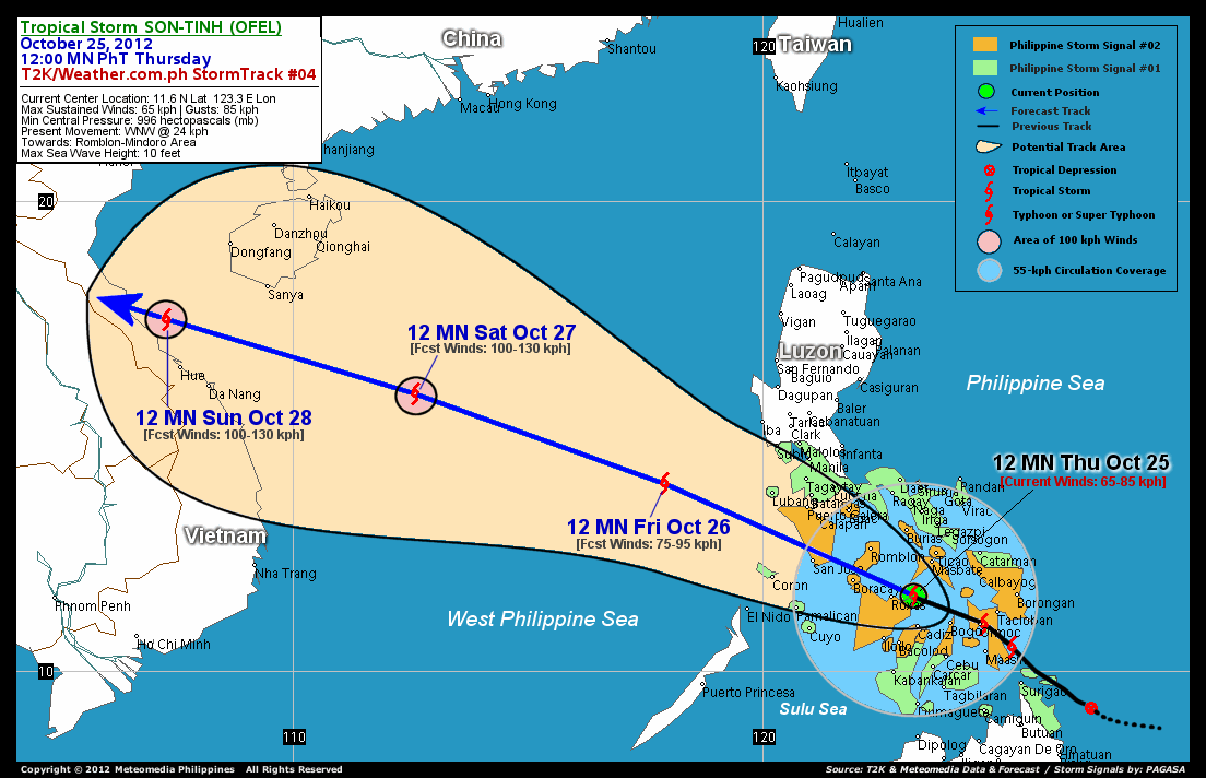
As of 12 midnight today, the center of Tropical Storm Son-Tinh (Ofel) was located off the Jintotolo Channel near the northern coast of Capiz...about 65 km east of Roxas City or 84 km south-southwest of Masbate City...currently moving west-northwest with a forward speed of 26 km/hr in the general direction of Romblon-Mindoro Area.
Maximum Sustained Winds (1-min. avg) remain at 65 km/hr near the center with higher gusts. Son-Tinh (Ofel) is an average-sized tropical cyclone with a diameter of 555 kilometers across. The 24-hour rainfall accumulation near the center of Son-Tinh (Ofel) is estimated to be heavy (200 mm).
3-DAY FORECAST OUTLOOK*
Tropical Storm Son-Tinh (Ofel) is expected to continue moving west-northwest during the next 24 hours with some fluctuations in its forward speed. It will therefore maintain its track throughout the forecast period. On the forecast track, the core of Son-Tinh (Ofel) is expected to pass in between Boracay and Tablas Island early this morning (approx 5-8AM) and is likely to make landfall along Southern Mindoro on or before noontime today. By Thursday afternoon, Son-Tinh (Ofel) may move out of Southern Mindoro, into the West Philippine Sea...and will leave the Philippine Area of Responsibility (PAR) on Friday afternoon. On Saturday through Sunday, Son-Tinh (Ofel) should be approaching the shores of Central Vietnam with a possible landfall just to the northwest of Hue City.
This storm is expected to slowly intensify once it emerges over the West Philippine Sea within the next 12 24 hours...and Son-Tinh (Ofel) could become a powerful Tropical Storm on Saturday while over the West Philippine-South China Sea Area.
The following is the summary of the 3-day forecast outlook on this system:
 FRIDAY MIDNIGHT: Moving overr the West Philippine Sea...farther away from the Philippines...about 273 km west-southwest of Subic Bay, Zambales [12AM OCT 26: 14.0N 117.9E @ 75kph].
SATURDAY MIDNIGHT: Becomes a strong Tropical Storm as it moves out of the Philippine Area of Responsibility (PAR)...about 471 km east of Da Nang, Vietnam [12AM OCT 27: 15.9N 112.6E @ 100kph].
SUNDAY MIDNIGHT: Just along the shores of Central Vietnam...at near typhoon intensity...about 116 km north-northwest of Hue, Vietnam [12AM OCT 28: 17.5N 107.3E @ 100kph].
*Please be reminded that the Forecast Outlook changes every 6 hours, and the Day 3 Forecast Track have an average error of 250 km...while the wind speed forecast error, averages 35 kph per day. Therefore, a turn to the left or right of its future track and changes in its wind speed must be anticipated from time to time.
EFFECTS & HAZARDS SUMMARY
Below is the summary of the storm's parts and its hazards affecting specific areas. You can also view this image link for you to understand the parts.
INNER RAINBANDS - affecting and spreading across Masbate, Ticao and Burias Islands, Northwestern Samar, Sorsogon, Albay, Central and Northern Panay incl. Boracay, Tablas-Romblon-Sibuyan Islands, and Biliran Island. Tropical Storm Conditions with Tropical Storm Force Winds (62-85 kph) will be expected along these bands. OUTER RAINBANDS - affecting and spreading across Metro Manila, Laguna, Rizal, Bulacan, Quezon Provinces, Southern Luzon, Rest of Bicol Region, the Rest of Visayas, Northern and Western Mindanao. Tropical Depression Conditions with moderate to strong winds (<62 kph) will be expected along these bands (click here to know more about Rainbands). 24HR TOTAL RAINFALL ACCUMULATION - from 5 up to 100 mm (light to heavy rainfall) can be expected along areas affected by the outer & inner rainbands (see above)...with isolated amounts of 101 to 200 mm (heavy) along areas near the center of Son-Tinh (Ofel). COASTAL STORM SURGE FLOODING - possible 1-3 ft (0.3-0.9 m) above normal tide levels...accompanied by large and dangerous battering waves can be expected along the coastal, inland lakes and beach front areas of Northern and Central Visayas including Boracay, Romblon and Masbate. Very minimal damage is likely on this type of storm surge. Danger from Rip Currents or Rip Tides can be expected along the rest of the beach-front areas of Bicol Region, Eastern and Southern Luzon, and Northern Visayas (click here to know more about Storm Surge).
Important Note: Please keep in mind that the above forecast outlook, effects and hazards summary changes every 6 to 12 hrs!
CURRENT TECHNICAL INFORMATION
Time/Date: 12:00 MN PhT Thu October 25, 2012
Class/Name: TS Son-Tinh (Ofel)
Location of Center: 11.6� N Lat 123.3� E Lon
Distance 1: 62 km (NW) away from Bantayan Island
Distance 2: 65 km (E) closer to Roxas City
Distance 3: 67 km (N) away from Cadiz City
Distance 4: 84 km (SSW) away from Masbate City
Distance 5: 101 km (NW) away from Bogo City
Distance 6: 119 km (NNE) away from Bacolod City
Distance 7: 126 km (NE) closer to Iloilo City
Distance 8: 155 km (SE) closer to Romblon
Distance 9: 156 km (ESE) closer to Boracay
Distance 10: 157 km (WNW) away from Ormoc City
Distance 11: 159 km (NNW) away from Metro Cebu
Distance 12: 188 km (WNW) away from Tacloban City
Distance 13: 223 km (S) away from Metro Naga
Distance 14: 252 km (SE) closer to San Jose, Occ.Mindoro
Distance 15: 410 km (SSE) closer to Metro Manila
MaxWinds (1-min avg): 65 kph near the center
Peak Wind Gusts: 85 kph
Present Movement: WNW @ 26 kph
Towards: Romblon-Mindoro Area
CPA [ETA] to Boracay-Romblon: Thursday Morning [5-7AM PhT]
24hr Rainfall Accum (near center): Heavy [200 mm]
Minimum Central Pressure: 996 millibars (hPa)
Size (in Diameter): 555 km [Average]
Max Sea Wave Height (near center): 10 feet
Possible Storm Surge Height: 1-3 ft (0.3-0.9 m)
T2K StormTracks (for Public): GIF | Google Map (Flash)

CURRENT NOAA/MTSAT-2 INFRARED SATELLITE IMAGE:

CURRENT TRACKING CHART:
_____________________________________________________________________________
>> To know the meteorological terminologies and acronyms used on this update visit the ff:
http://typhoon2000.ph/tcterm.htm
http://www.nhc.noaa.gov/aboutgloss.shtml
http://www.nhc.noaa.gov/acronyms.shtml
__________________________________________________________________________________________
For the complete details on TS SON-TINH (OFEL)...go visit our website @:
> http://www.typhoon2000.com
> http://www.maybagyo.com
<<<Typhoon2000.com Mobile >>>
Get the latest SMS Storm Alerts!
For more details: Text T2K TYPHOON to
2800 (Globe/TM) | 216 (Smart/TNT) | 2288 (Sun)
*Only P2.50 (Smart/Globe) / P2.00 (Sun) per msg received.
Click here on how to use this service (in PDF file)
Powered by: Synermaxx Corporation
Copyright © 2012 Typhoon2000.com All Rights Reserved
| Reply via web post | Reply to sender | Reply to group | Start a New Topic | Messages in this topic (1) |

No comments:
Post a Comment