
WEATHER.COM.PH / T2K TROPICAL CYCLONE UPDATES
TROPICAL STORM GAEMI (MARCE) UPDATE NUMBER 009
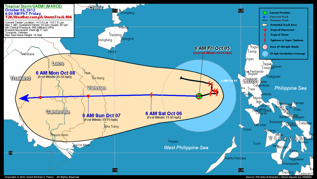
Issued: 6:00 AM PhT (22:00 GMT) Fri 05 October 2012
Next Update: 12:00 NN PhT (04:00 GMT) Fri 05 October 2012
Tropical Storm GAEMI (MARCE) has weakened slightly during the past 12 hours...now moving westward slowly across the West Philippine Sea, away from Luzon. Its rainbands has moved away from Western Luzon...improving weather expected.
Residents and visitors along Vietnam, Laos and Cambodia should closely monitor the development of Gaemi (Marce).
Do not use this for life or death decision. This update is intended for additional information purposes only. Kindly refer to your national weather agency for official warnings, advisories or bulletins.
CURRENT STORM ANALYSIS
As of 6 am today, the center of Tropical Storm Gaemi (Marce) was located over the West Philippine Sea...about 389 km west of Subic Bay or 474 km west of Quezon City and is currently moving west with a forward speed of 11 kph in the general direction of Vietnam.
Maximum Sustained Winds (1-min. avg) have decreased to 65 km/hr near the center with higher gusts. These winds will remain over the West Philippine Sea and will not affect any land areas. Gaemi (Marce) is an average-sized tropical cyclone with a diameter of 555 kilometers across. The 24-hour rainfall accumulation near the center of Gaeme (Marce) is estimated to be heavy (350 mm).
3-DAY FORECAST OUTLOOK*
Gaemi (Marce) is expected to continue moving westward during the next 12 to 24 hours, accelerating more to the West through 72 hours. On the forecast track, the center of Gaemi (Marce) will remain over the open waters of the West Philippine and South China Seas, and will exit the Philippine Area of Responsibility (PAR) tonight. This storm is forecast to make landfall over Vietnam on Sunday.
Some slight re-strengthening of its wind speed is forecast during the next 24 hours before it starts to decay. Gaemi (Marce) is likely to dissipate once it makes landfall over Vietnam.
The following is the summary of the 3-day forecast outlook on this system:
 SATURDAY MORNING: Accelerating westward towards Vietnam...exits the PAR as it slightly intensify...about 531 km east-southeast of Da Nang, Vietnam [6AM OCT 06: 14.6N 112.9E @ 75kph].
SUNDAY MORNING: Makes landfall over Vietnam...weakens to a Tropical Depression...about 181 km south-southwest of Da Nang, Vietnam [6AM OCT 07: 14.5N 107.9E @ 55kph].
MONDAY MORNING: Dissipating along the Cambodian and Thai Border...just a Tropical Disturbance (LPA) [6AM OCT 08: 14.4N 104.1E @ 35kph].
*Please be reminded that the Forecast Outlook changes every 6 hours, and the Day 3 Forecast Track have an average error of 250 km...while the wind speed forecast error, averages 35 kph per day. Therefore, a turn to the left or right of its future track and changes in its wind speed must be anticipated from time to time.
EFFECTS & HAZARDS SUMMARY
Below is the summary of the storm's parts and its hazards affecting specific areas. You can also view this image link for you to understand the parts.
INNER RAINBANDS - over water (West Philippine Sea)...not affecting any land areas.. Tropical Storm Conditions with Tropical Storm Force Winds (62-117 kph) will be expected along these bands. SCATTERED OUTER RAINBANDS - over water (West Philippine Sea)...no longer affecting any land areas...but is expected to reach the coastal areas of Eastern Vietnam on Saturday. Cloudy/Rainy Conditions with moderate to strong winds (<62 kph) will be expected along these bands (click here to know more about Rainbands). 24HR TOTAL RAINFALL ACCUMULATION - from 5 up to 200 mm (low to heavy rainfall) can be expected along areas affected by the outer & inner rainbands (see above)...with isolated amounts of 201 to 350 mm (heavy) along areas near the center of Gaemi (Marce).
Important Note: Please keep in mind that the above forecast outlook, effects-hazards, current monsoon intensity, & tropical cyclone watch changes every 6 to 12 hrs!
CURRENT TECHNICAL INFORMATION
Time/Date: 6:00 AM PhT Fri October 05, 2012
Class/Name: Tropical Storm Gaemi (Marce)
Location of Center: 14.5º N Lat 116.7º E Lon
Distance 1: 366 km (WSW) away from Iba, Zambales
Distance 2: 389 km (W) away from Subic Bay
Distance 3: 421 km (WSW) away from Dagupan City
Distance 4: 426 km (WSW) away from Clark Intl. Airport
Distance 5: 474 km (W) away from Quezon City
MaxWinds (1-min avg): 65 kph near the center
Peak Wind Gusts: 85 kph
Present Movement: West @ 11 kph
Towards: Vietnam
24hr Rainfall Accum (near center): Heavy [350 mm]
Minimum Central Pressure: 996 millibars (hPa)
Size (in Diameter): 555 km (300 nm) [Average]
Max Sea Wave Height (near center): 18 ft
Possible Coastal Storm Surge Height: 1-3 ft (0.3-0.9 m)
T2K StormTracks (for Public): Google Map (Flash) | GIF (for Philippines only)

CURRENT NOAA/MTSAT-2 INFRARED (IR) SATELLITE IMAGE:

CURRENT TYPHOON2000.COM / WEATHER.COM.PH TRACKING MAP:
 _____________________________________________________________________________
>> To know the meteorological terminologies and acronyms used on this update visit the ff:
http://typhoon2000.ph/tcterm.htm
http://www.nhc.noaa.gov/aboutgloss.shtml
http://www.nhc.noaa.gov/acronyms.shtml
__________________________________________________________________________________________
For the complete details on TS GAEMI (MARCE)...go visit our website @:
> http://www.typhoon2000.com
> http://www.maybagyo.com
<<<Typhoon2000.com Mobile >>>
Get the latest SMS Storm Alerts!
For more details: Text T2K TYPHOON to
2800 (Globe/TM) | 216 (Smart/TNT) | 2288 (Sun)
*Only P2.50 (Smart/Globe) / P2.00 (Sun) per msg received.
Click here on how to use this service (in PDF file)
Powered by: Synermaxx Corporation
Copyright © 2012 Typhoon2000.com All Rights Reserved
| Reply via web post | Reply to sender | Reply to group | Start a New Topic | Messages in this topic (1) |

No comments:
Post a Comment