Typhoon2000 STORM UPDATE #009
Name: TROPICAL STORM FENGSHEN [FRANK/07W/0806]
Issued: 7:00 AM MANILA TIME (23:00 GMT) TUE 24 JUNE 2008
Source: JTWC TROPICAL CYCLONE WARNING #022
Note: Kindly refer to your country's official warnings or bulletins. This update is for additional information purposes only.
Source: JTWC TROPICAL CYCLONE WARNING #022
Note: Kindly refer to your country's official warnings or bulletins. This update is for additional information purposes only.
_____________________________________________________________________________
FENGSHEN (FRANK) WEAKENS INTO A TROPICAL STORM AS IT EXITS THE
NORTHWESTERN BORDER OF THE PHILIPPINE AREA OF RESPONSIBILITY (PAR)...
THREATENS SOUTHERN CHINA PARTICULARY EASTERN GUANGDONG PROVINCE...NO
LONGER A THREAT TO THE PHILIPPINES.
+ FORECAST OUTLOOK: FENGSHEN is expected to turn Northward within the
next 24 hours and shall gain strength before making landfall. The 2 to
5-day long-range forecast shows the system making landfall over Eastern
Guangdong in China (passing north of Shantou City) tomorrow morning,
and shall move across Fujian Province tomorrow afternoon - passing to
the north of Xiamen City in the evening, and north of Fuzhou City by
early Thursday morning (June 26). FENGSHEN shall then exit to the East
China Sea on Friday morning, and accelerate Northeastward across the
Sea of Japan, passing in between South Korea & Japan.
over the South China Sea is no longer affecting Western Philippines.
+ CURRENT MONSOON INTENSITY: The Southwest (SW) Monsoon continues to be
enhanced by FENSGHEN, affecting Western & Southern Luzon, Mindoro, Bicol
Region, Palawan & Western Visayas. Cloudy skies with light to moderate
passing rains & SW'ly winds not exceeding 40 km/hr may be expected.
Landslides, mudflows (lahars) and flooding is likely to occur along
steep mountain/volcano slopes, river banks, low-lying & flood-prone
areas of the affected areas. Meanwhile, big sea waves or surges gene-
rated by this monsoon can affect the coastal and beach-front areas of
the abovementioned areas. Strong ITCZ (aka. Monsoon Trough) affecting
the whole Philippines - may continue to bring scattered rains and
chances of scattered thunderstorms - most especially in the afternoon
or evening.
Important Note: Please keep in mind that the above forecast outlook,
effects & current monsoon intensity, and tropical cyclone watch changes
every 06 to 12 hours!
____________
TIME/DATE: 5:00 AM MANILA TIME (23:00 GMT) 24 JUNE
LOCATION OF CENTER: LATITUDE 18.7º N...LONGITUDE 116.2º E {Sat Fix}
DISTANCE 1: 465 KM (250 NM) WNW OF LAOAG CITY, PH
DISTANCE 2: 440 KM (240 NM) SSE OF HONG KONG, CHINA
DISTANCE 3: 525 KM (285 NM) SSE OF SHANTOU, CHINA
DISTANCE 4: 610 KM (330 NM) SW OF KAOSHIUNG, CHINA
MAX WINDS [1-MIN AVG]: 100 KM/HR (55 KTS) NEAR THE CENTER
PEAK WIND GUSTS: 130 KM/HR (70 KTS)
SAFFIR-SIMPSON SCALE: N/A
MINIMUM CENTRAL PRESSURE (est.): 982 MILLIBARS (hPa)
RECENT MOVEMENT: NW @ 13 KM/HR (07 KTS)
GENERAL DIRECTION: SOUTHERN CHINA
STORM'S SIZE (IN DIAMETER): 500 KM (270 NM)/AVERAGE
MAX WAVE HEIGHT**: 18 FEET (5.4 METERS)
VIEW TRACKING MAP: 2 AM MANILA TIME TUE JUNE 24
TSR WIND PROBABILITIES: CURRENT TO 120 HRS LEAD
PHILIPPINE STORM SIGNALS*: NOW LOWERED
12, 24, 48, 72 HR. FORECAST:
2 PM (06 GMT) 24 JUNE: 20.1N 115.8E / 110-140 KPH / N @ 15 KPH
2 AM (18 GMT) 25 JUNE: 21.7N 115.9E / 100-130 KPH / NNE @ 26 KPH
2 AM (18 GMT) 26 JUNE: 26.0N 119.0E / 85-100 KPH / NE @ 22 KPH
2 AM (18 GMT) 27 JUNE: 29.2N 122.9E / 85-100 KPH / NE @ 26 KPH
REMARKS: 2 AM (18 GMT) 24 JUNE POSITION: 18.5N 116.3E.
^TROPICAL STORM (TS) 07W HAS MAINTAINED INTENSITY OVER THE PAST 12
HOURS. ANIMATED INFRARED SATELLITE IMAGERY SHOWED THAT THE LOW-LEVEL
CIRCULATION CENTER (LLCC) BECAME PARTIALLY-EXPOSED BUT DEEP CONVECT-
ION QUICKLY RE-DEVELOPED OVER THE CENTER DESPITE MODERATE TO STRONG
VERTICAL WIND SHEAR (VWS). A 231136Z SSMIS 37 GHZ MICROWAVE IMAGE
DEPICTED A WELL-DEFINED CENTER WITH IMPROVED CONVECTIVE BANDING. TS
07W HAS TRACKED INCREASINGLY POLEWARD AND IS CURRENTLY TRACKING
NORTHWESTWARD AT 08 KNOTS. THE DYNAMIC MODEL TRACK GUIDANCE HAS
REMAINED CONSISTENT...(more).
>> FENGSHEN {pronounced: feng~shen}, meaning: God of Wind.
Name contributed by: China.
_____________________________________________________________________________
RECENT WUNDERGROUND.COM T2K TRACKING CHART :
2 AM (18 GMT) 27 JUNE: 29.2N 122.9E / 85-100 KPH / NE @ 26 KPH
REMARKS: 2 AM (18 GMT) 24 JUNE POSITION: 18.5N 116.3E.
^TROPICAL STORM (TS) 07W HAS MAINTAINED INTENSITY OVER THE PAST 12
HOURS. ANIMATED INFRARED SATELLITE IMAGERY SHOWED THAT THE LOW-LEVEL
CIRCULATION CENTER (LLCC) BECAME PARTIALLY-EXPOSED BUT DEEP CONVECT-
ION QUICKLY RE-DEVELOPED OVER THE CENTER DESPITE MODERATE TO STRONG
VERTICAL WIND SHEAR (VWS). A 231136Z SSMIS 37 GHZ MICROWAVE IMAGE
DEPICTED A WELL-DEFINED CENTER WITH IMPROVED CONVECTIVE BANDING. TS
07W HAS TRACKED INCREASINGLY POLEWARD AND IS CURRENTLY TRACKING
NORTHWESTWARD AT 08 KNOTS. THE DYNAMIC MODEL TRACK GUIDANCE HAS
REMAINED CONSISTENT...(more).
>> FENGSHEN {pronounced: feng~shen}, meaning: God of Wind.
Name contributed by: China.
____________
_____________________________________________________________________________
RECENT WUNDERGROUND.
________________________
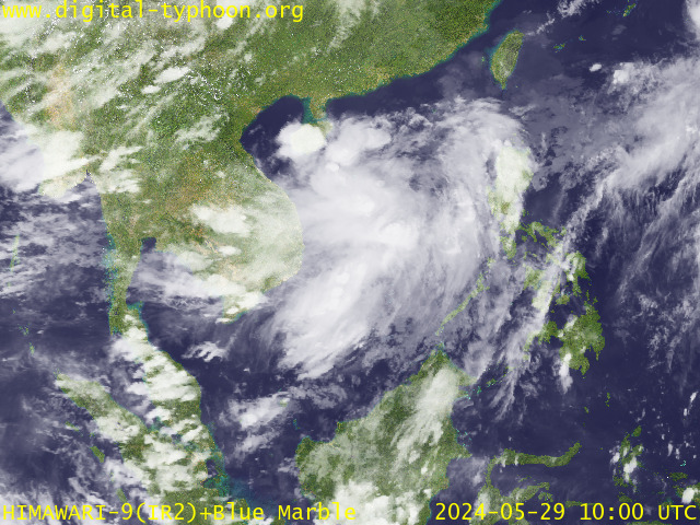
RECENT MTSAT-1R SATELLITE IMAGE:

> Image source: Digital-Typhoon (http://www.digital-typhoon.org )
__________________________________________________________________________________________
NOTES:

> Image source: Digital-Typhoon (http://www.digital-
____________
^ - JTWC commentary remarks (for Meteorologists) from their
latest warning.
latest warning.
* - Based on PAGASA's Philippine Storm Warning Signals,
# 4 being the highest. For more explanations on these
signals, visit: http://www.typhoon2000.ph/signals.htm
** - Based on the Tropical Cyclone's Wave Height near
its center.
__________________________________________________________________________________________
>> To know the meteorological terminologies and acronyms
used on this update visit the ff:
http://typhoon2000.ph/tcterm.htm
http://www.nhc.noaa.gov/aboutgloss.shtml
http://www.srh.noaa.gov/oun/severewx/glossary.php
http://www.srh.weather.gov/fwd/glossarynation.html
http://www.nhc.noaa.gov/acronyms.shtml
__________________________________________________________________________________________
:: Typhoon2000.com (T2K) Mobile >> Powered by: Synermaxx
Receive the latest storm updates directly to your mobile phones! To know more:
Send T2K HELP to: 2800 (GLOBE & TM) | 216 (SMART & TNT) | 2288 (SUN)
Note: Globe & Smart charges P2.50 per message, while Sun at P2.00.
__________________________________________________________________________________________
For the complete details on TS FENGSHEN (FRANK)...go visit
our website @:
> http://www.typhoon2000.com
> http://www.maybagyo.com
# 4 being the highest. For more explanations on these
signals, visit: http://www.typhoon2
** - Based on the Tropical Cyclone's Wave Height near
its center.
____________
>> To know the meteorological terminologies and acronyms
used on this update visit the ff:
http://typhoon2000.
http://www.nhc.
http://www.srh.
http://www.srh.
http://www.nhc.
____________
:: Typhoon2000.
Receive the latest storm updates directly to your mobile phones! To know more:
Send T2K HELP to: 2800 (GLOBE & TM) | 216 (SMART & TNT) | 2288 (SUN)
Note: Globe & Smart charges P2.50 per message, while Sun at P2.00.
For the complete details on TS FENGSHEN (FRANK)...go visit
our website @:
> http://www.typhoon2
> http://www.maybagyo
Copyright © 2008 Typhoon2000.
MARKETPLACE
Change settings via the Web (Yahoo! ID required)
Change settings via email: Switch delivery to Daily Digest | Switch format to Traditional
Visit Your Group | Yahoo! Groups Terms of Use | Unsubscribe
.
__,_._,___
No comments:
Post a Comment