for Sunday, 02 February 2014 [12:52 PM PhT]
WEATHER.COM.PH TROPICAL CYCLONE UPDATES
EX-TROPICAL DEPRESSION KAJIKI (BASYANG) UPDATE NUMBER 009 [FINAL]
Issued at: 6:00 AM PhT (22:00 GMT) Sunday 02 February 2014
KAJIKI (BASYANG) has dissipated into an area of low pressure...and quickly moved westward across the West Philippine and South China Seas.
*This is the last and final update on Kajiki (Basyang).
Information based on data collected by WeatherPhilippines Foundation, Inc. shall not be taken as official data. Weather information broadcasted and distributed by PAGASA remains as official data. WeatherPhilippines shall not be responsible for the private use and reliance of its weather information.
CURRENT CYCLONE INFORMATION
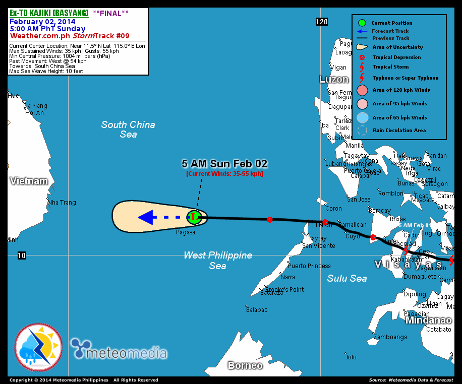
As of 5:00 AM PhT today...2100 GMT...
Location: Over the West Philippine-South China Seas (near 11.5N 115.0E)
About: 90 km northeast of Pagasa Island
Maximum Sustained Winds (1-min avg): 35 kph near the center...Gustiness: 55 kph
Past Movement: West at 54 kph
Towards: South China Sea
CYCLONE HAZARDS AFFECTING LAND
Below are the regions or places with possible or ongoing effects caused by the current tropical cyclone.
 NONE .
Important Note: Please keep in mind that the above forecast outlook and hazards summary changes every 6 to 12 hrs!
ADDITIONAL DISTANCES & TECHNICAL INFO
Time/Date: 5:00 AM PhT Sun Feb 02, 2014
Class/Name: Ex-TD Kajiki (Basyang)
Minimum Central Pressure: 1004 millibars (hPa)
Location of Center: Near 11.5º N Lat 115.0º E Lon
Distance 1: 90 km NE of Pagasa Island, Spratlys
Distance 2: 515 km W of El Nido, Palawan
Distance 3: 635 km ESE of Nha Trang, Vietnam
Distance 4: 450 km NW of Puerto Princesa, Palawan
Distance 5: 735 km SW of Metro Manila
T2K/WP StormTracks (for Public): GIF
CURRENT TRACKING MAP:
 _____________________________________________________________________________
__________________________________________________________________________________________________
CURRENT NOAA/MTSAT-2 INFRARED (IR) SATELLITE IMAGE:

__________________________________________________________________________________________________
>> To know the meteorological terminologies and acronyms used on this update visit the ff:
http://typhoon2000.ph/tcterm.htm
http://www.nhc.noaa.gov/aboutgloss.shtml
http://www.nhc.noaa.gov/acronyms.shtml
__________________________________________________________________________________________
For the complete details on TD KAJIKI (BASYANG)...go visit our website @:
> http://www.typhoon2000.com
> http://www.maybagyo.com
<<<Typhoon2000.com Mobile >>>
Get the latest SMS Storm Alerts!
For more details: Text T2K TYPHOON to
2800 (Globe/TM) | Offline (Smart/TNT) | 2288 (Sun)
*Only P2.50 (Smart/Globe) / P2.00 (Sun) per msg received.
Click here on how to use this service (in PDF file)
Powered by: Synermaxx Corporation
Copyright © 2014 Typhoon2000.com All Rights Reserved
| Reply via web post | Reply to sender | Reply to group | Start a New Topic | Messages in this topic (1) |
No comments:
Post a Comment