
WEATHER.COM.PH TROPICAL CYCLONE UPDATES
TYPHOON SOULIK (HUANING) UPDATE NUMBER 014
Issued: 7:00 AM PhT (23:00 GMT) Saturday 13 July 2013
Next Update: 1:00 PM PhT (05:00 GMT) Saturday 13 July 2013
Typhoon SOULIK (HUANING) has moved quickly during the past 12 hours and made landfall over Northern Taiwan early this morning...now emerging along the northwestern shores of Taiwan, entering the Strait of Taiwan. Typhoon Force Winds w/ moderate to heavy rains continues to prevail across the area.
Residents and visitors along Taiwan and Southeastern China should closely monitor the development of Soulik (Huaning).
Do not use this for life or death decisions. This update is intended for additional information purposes only. Kindly refer to your national weather agency for official warnings, advisories or bulletins.
CURRENT STORM ANALYSIS
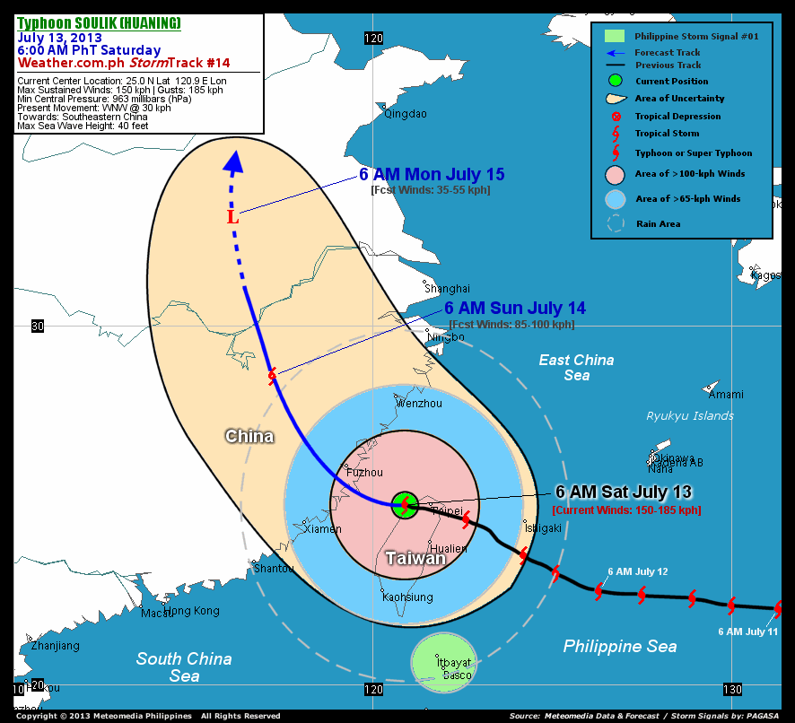
As of 6:00 am today, the eye of Typhoon Soulik (Huaning) was located over the northwestern coast of Taiwan...about 70 km west of Taipei, Taiwan or 200 km southeast of Taipei, Taiwan...currently moving west-northwest with an accelerated forward speed of 30 km/hr in the general direction of Fujian Province, Southeastern China.
Maximum Sustained Winds (1-min. avg) have decreased to near 150 km/hr near the center with higher gusts. Typhoon Force Winds (118 km/hr or more) extend outward up to 85 kilometers from the center...and Tropical Storm Force Winds (62-117 km/hr) extend outward up to 370 kilometers. Soulik (Huaning) is a very large-sized tropical cyclone with a diameter of 905 kilometers across. The 24-hour rainfall accumulation near the center of Soulik (Huaning) is estimated to be heavy (300 mm).
2-DAY FORECAST OUTLOOK*
Typhoon Soulik (Huaning) is expected to continue moving west-northwest during the next 12 hours...turning northwest to north-northwest between 12 to 48 hours. On the forecast track, the core of Soulik (Huaning) will make landfall along Fujian Province, passing over or very near Fuzhou City, China this afternoon or evening. On Sunday until Monday, the cyclone will be moving along the rugged terrain of mainland China, crossing the Fujian-Zhejiang-Jiangxi border.
Soulik (Huaning) will continue to weaken upon its final landfall over Fujian Province in Southeastern China later today. Advance intensity forecast shows the system starting to gradually weaken as it moves over land across mainland China throughout Sunday and will dissipate into an area of low pressure while remaining over mainland China on Monday morning.
The following is the summary of the 2-day forecast outlook on this system:
 SUNDAY MORNING: Weakens into a TS as it moves across Mainland China...about 350 km west-northwest of Wenzhou, China [6AM JULY 14: 28.6N 117.2E @ 85kph].
MONDAY MORNING: Dissipated over Mainland China...just a very weak Tropical Disturbance (LPA)...about 540 km west-northwest of Shanghai, China [6AM JULY 15: 33.1N 116.1E @ 35kph].
*Please be reminded that the Forecast Outlook changes every 6 hours, and the Day 3 Forecast Track have an average error of 250 km...while the wind speed forecast error, averages 35 kph per day. Therefore, a turn to the left or right of its future track and changes in its wind speed must be anticipated from time to time.
EFFECTS & HAZARDS SUMMARY
Below is the summary of the storm's parts and its hazards affecting specific areas. You can also view this image link for you to understand the parts.
CLOUD-FILLED EYE - over water (Taiwan Strait). Affected Areas: Shores of Northwestern Taiwan. Possible calm and lull conditions (with <20 kph winds) will be expected inside the eye (click here to know more about the EYE). EYEWALL - over water (Taiwan Strait) and land areas. Affected Areas: Northwestern Taiwan. Typhoon Conditions with Typhoon Force Winds (>118 kph) will be expected within this wall (click here to know more about the Eyewall). INNER RAINBANDS - over water (Taiwan Strait) and land areas. Affected Areas: The Rest of Taiwan. Tropical Storm Conditions with Tropical Storm Force Winds (63-117 kph) will be expected along these bands. OUTER RAINBANDS - over water (Northernmost Philippine Sea & East China Sea), smaller islands, and land areas. -- Affected Areas: Southeastern China and the islands of Batanes-Calayan-Babuyan-Yaeyama-Miyako-Ryukyus incl. Okinawa. Tropical Depression Conditions with light, moderate to strong winds (30-62 kph) will be expected along these bands (click here to know more about Rainbands). 24HR TOTAL RAINFALL ACCUMULATION - from 5 up to 100 mm (slight to heavy rainfall) can be expected along areas affected by the outer & inner rainbands (see above)...with isolated amounts of 101 to 300 mm (heavy) along areas near the center of Soulik (Huaning). COASTAL STORM SURGE FLOODING - possible 4-5 ft (1.2-1.7 m) above normal tide levels...accompanied by large and dangerous battering waves can be expected along the coastal, inland lakes and beach front areas of Taiwan and Southeastern China especially Fujian Province today. Minimal damage is likely on this type of storm surge. Danger from Rip Currents or Rip Tides can be expected along the rest of the beach-front areas of Southern and Eastern China, Yaeyama-Miyako-Ryukyu Islands, and Extreme Northern Luzon including Batanes-Babuyan-Calayan Islands (click here to know more about Storm Surge).
Important Note: Please keep in mind that the above forecast outlook, effects and hazards summary changes every 6 to 12 hrs!
CURRENT TECHNICAL INFORMATION
Time/Date: 6:00 AM PhT Sat July 13, 2013
Class/Name: TY Soulik (Huaning)
Location of Eye: 25.0º N Lat 120.9º E Lon
Distance 1: 70 km W of Taipei, Taiwan
Distance 2: 130 km NNW of Hualien, Taiwan
Distance 3: 200 km SE of Fuzhou, China
Distance 4: 275 km NNE of Kaohsiung, Taiwan
Distance 5: 290 km ENE of Xiamen, China
Distance 6: 340 km WNW of Ishigaki City
Distance 7: 475 km NNW of Itbayat, Batanes
Distance 8: 515 km NNW of Basco, Batanes
MaxWinds (1-min avg): 150 kph near the center
Peak Wind Gusts: 185 kph
Present Movement: WNW @ 30 kph
Towards: Southeastern China
CPA [ETA] to Fujian Province: Sat Afternoon [4-6PM PhT]
24hr Rainfall Accum (near center): Heavy [300 mm]
Minimum Central Pressure: 963 millibars (hPa)
Size (in Diameter): 905 km [Very Large]
Max Sea Wave Height (near center): 40 feet
Possible Storm Surge Height: 4-5 ft (1.2-1.7 m)
T2K/WP StormTracks (for Public): GIF | Google Map (Flash)

__________________________________________________________________________________________________
CURRENT NOAA/MTSAT-2 INFRARED (IR) SATELLITE IMAGE:

CURRENT TRACKING MAP:
 _____________________________________________________________________________
>> To know the meteorological terminologies and acronyms used on this update visit the ff:
http://typhoon2000.ph/tcterm.htm
http://www.nhc.noaa.gov/aboutgloss.shtml
http://www.nhc.noaa.gov/acronyms.shtml
__________________________________________________________________________________________
For the complete details on TY SOULIK (HUANING)...go visit our website @:
> http://www.typhoon2000.com
> http://www.maybagyo.com
<<<Typhoon2000.com Mobile >>>
Get the latest SMS Storm Alerts!
For more details: Text T2K TYPHOON to
2800 (Globe/TM) | Offline (Smart/TNT) | 2288 (Sun)
*Only P2.50 (Smart/Globe) / P2.00 (Sun) per msg received.
Click here on how to use this service (in PDF file)
Powered by: Synermaxx Corporation
Copyright © 2013 Typhoon2000.com All Rights Reserved
| Reply via web post | Reply to sender | Reply to group | Start a New Topic | Messages in this topic (1) |

No comments:
Post a Comment