
WEATHER.COM.PH TROPICAL CYCLONE UPDATES
TROPICAL DEPRESSION CIMARON (ISANG) UPDATE NUMBER 010 [FINAL]
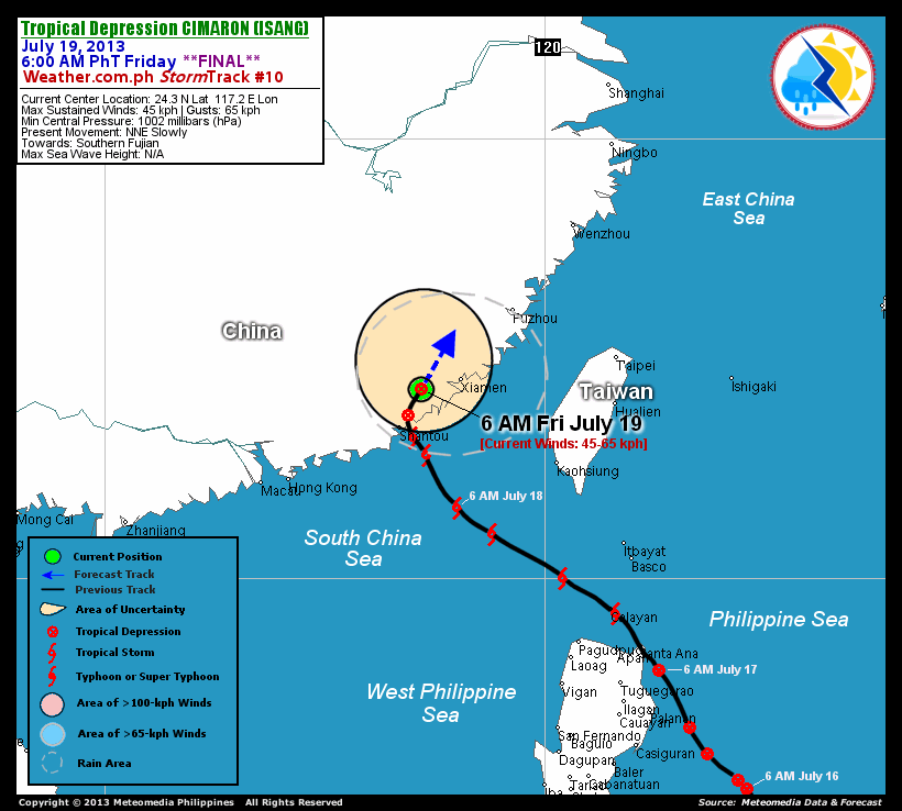
Issued: 7:00 AM PhT (23:00 GMT) Friday 19 July 2013
CIMARON (ISANG) downgraded to a Tropical Depression (TD) as it lingers over the southern part of Fujian Province in Southern China. Dissipating rainbands will continue to dump moderate to heavy rains over the area.
*This is the last and final update on Cimaron (Isang).
Do not use this for life or death decisions. This update is intended for additional information purposes only. Kindly refer to your national weather agency for official warnings, advisories or bulletins.
CURRENT STORM ANALYSIS
As of 6:00 am today, the center of TD Cimaron (Isang) was located over Southern Fujian...about 95 km west-southwest of Xiamen City, China or 100 km north-northeast of Shantou City, China...currently moving north-northeast slowly.
Maximum Sustained Winds (1-min. avg) have decreased to near 45 km/hr near the center with higher gusts. Cimaron (Isang) is a small-sized tropical cyclone with a diameter of 300 kilometers across. The 24-hour rainfall accumulation near the center of Cimaron (Isang) is estimated to be extreme (400 mm).
EFFECTS & HAZARDS SUMMARY
Below is the summary of the storm's parts and its hazards affecting specific areas. You can also view this image link for you to understand the parts.
 DECAYING RAINBANDS - where Tropical Depression Conditions with light, moderate to strong winds (30-55 kph) will be expected. Affected Areas: The rest of the coastal areas of Eastern Guangdong and Fujian, and Taiwan Strait. (click here to know more about Rainbands) 24HR TOTAL RAINFALL ACCUMULATION - from 5 up to 100 mm (slight to heavy rainfall) can be expected along areas affected by the outer & inner rainbands (see above)...with isolated amounts of 101 to 400 mm (heavy) along areas to the east and near the center of Cimaron (Isang).
Important Note: Please keep in mind that the above forecast outlook, effects and hazards summary changes every 6 to 12 hrs!
CURRENT TECHNICAL INFORMATION
Time/Date: 6:00 AM PhT Fri July 19, 2013
Class/Name: TD Cimaron (Isang)
Location of Center: 24.3º N Lat 117.2º E Lon
Distance 1: 95 km WSW of Xiamen, China
Distance 2: 100 km NNE of Shantou, China
Distance 3: 290 km SW of Fuzhou, Taiwan
Distance 4: 370 km NW of Kaohsiung, Taiwan
Distance 5: 380 km ENE of Hong Kong
MaxWinds (1-min avg): 45 kph near the center
Peak Wind Gusts: 65 kph
Present Movement: NNE Slowly
Towards: Southern Fujian
24hr Rainfall Accum (near center): Extreme [400 mm]
Minimum Central Pressure: 1002 millibars (hPa)
Size (in Diameter): 300 km [Small]
Max Sea Wave Height (near center): 16 feet
Possible Storm Surge Height: 0 ft (0 m)
T2K/WP StormTracks (for Public): GIF | Google Map (Flash)
CURRENT TRACKING MAP:
 _____________________________________________________________________________
__________________________________________________________________________________________________
CURRENT NOAA/MTSAT-2 INFRARED (IR) SATELLITE IMAGE:

__________________________________________________________________________________________________
>> To know the meteorological terminologies and acronyms used on this update visit the ff:
http://typhoon2000.ph/tcterm.htm
http://www.nhc.noaa.gov/aboutgloss.shtml
http://www.nhc.noaa.gov/acronyms.shtml
__________________________________________________________________________________________
For the complete final details on TD CIMARON (ISANG)...go visit our website @:
> http://www.typhoon2000.com
> http://www.maybagyo.com
<<<Typhoon2000.com Mobile >>>
Get the latest SMS Storm Alerts!
For more details: Text T2K TYPHOON to
2800 (Globe/TM) | Offline (Smart/TNT) | 2288 (Sun)
*Only P2.50 (Smart/Globe) / P2.00 (Sun) per msg received.
Click here on how to use this service (in PDF file)
Powered by: Synermaxx Corporation
Copyright © 2013 Typhoon2000.com All Rights Reserved
| Reply via web post | Reply to sender | Reply to group | Start a New Topic | Messages in this topic (1) |

No comments:
Post a Comment