
WEATHER.COM.PH TROPICAL CYCLONE UPDATES
TYPHOON SOULIK (HUANING) UPDATE NUMBER 009
Issued: 1:00 PM PhT (05:00 GMT) Thursday 11 July 2013
Next Update: 7:00 PM PhT (11:00 GMT) Thursday 11 July 2013
Typhoon SOULIK (HUANING) still losing strength while moving across the Western Pacific...just a Category 3 cyclone...threat to Yaeyama-Miyako-Northern Taiwan Area continues.
Residents and visitors along Batanes Group of Islands, Taiwan, Yaeyama and Miyako Islands, Okinawa and the Ryukyu Islands should closely monitor the development of Soulik (Huaning).
Do not use this for life or death decisions. This update is intended for additional information purposes only. Kindly refer to your national weather agency for official warnings, advisories or bulletins.
CURRENT STORM ANALYSIS
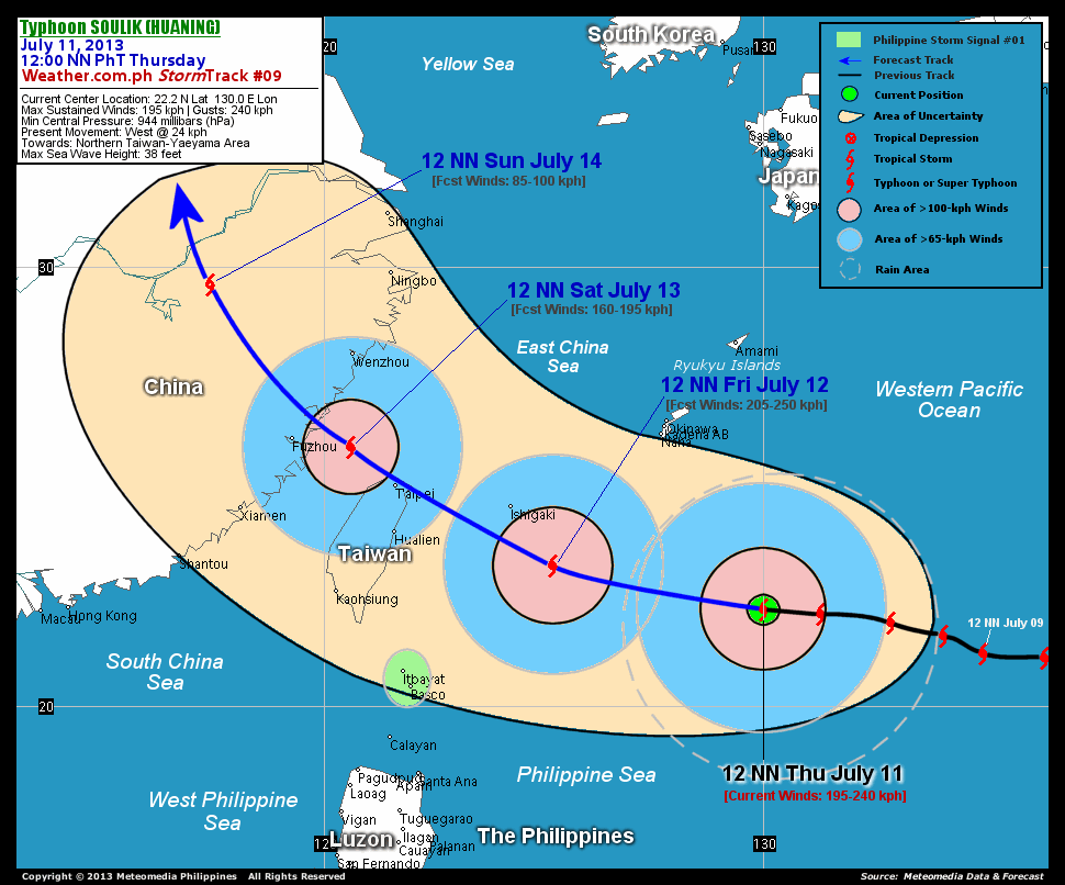
As of 12:00 noon today, the eye of Typhoon Soulik (Huaning) was located over the open seas of the Western Pacific Ocean...about 500 km south-southeast of Naha International Airport, Okinawa or 850 km east-northeast of Basco, Batanes...currently moving west with a decreased forward speed of 24 km/hr in the general direction of Yaeyama Islands-Northern Taiwan Area.
Maximum Sustained Winds (1-min. avg) have decreased to 195 km/hr near the center with higher gusts. Typhoon Force Winds (118 km/hr or more) extend outward up to 100 kilometers from the center...and Tropical Storm Force Winds (62-117 km/hr) extend outward up to 315 kilometers. Soulik (Huaning) remains a very large-sized tropical cyclone with a diameter of 945 kilometers across. The 24-hour rainfall accumulation near the center of Soulik (Huaning) is estimated to be extreme (400 mm).
3-DAY FORECAST OUTLOOK*
Typhoon Soulik (Huaning) is expected to move towards the west-northwest during the next 24 hours...turning northwest to north-northwest between 24 to 72 hours. On the forecast track, the core of Soulik (Huaning) will pass close to the south of Yaeyama Islands on Friday afternoon...passing along the Northeastern tip of Taiwan - very close to Taipei on or before sunrise on Saturday (approx 5-7am). By Saturday noon, the typhoon will be moving across the Taiwan Strait and will make its final landfall over Fujian Province, just to the northeast of Fuzhou City, China on Saturday evening. Throughout Sunday, the cyclone will be moving along the rugged terrain of China or along the Fujian-Zhejiang-Jiangxi border.
Soulik (Huaning) will likely to re-intensify within the next 24 hours. Advance intensity forecast shows the system starting to weaken as it passes over Northern Taiwan on Saturday morning and will be downgraded to a Tropical Storm (TS) while over mainland China on Sunday noon due to frictional effects of land and dry air entering the system.
The following is the summary of the 3-day forecast outlook on this system:
 FRIDAY NOON: Regains strength as it approaches the Yaeyama and Miyalp Islands...about 170 km southeast of Naha International Airport, Okinawa [12PM JULY 12: 23.2N 125.2E @ 205kph].
SATURDAY NOON: Over Taiwan Strait as it approaches Southeastern China (Fuzhou Province)...gradually weakens...about 130 km east-southeast of Fuzhou, China [12PM JULY 13: 25.9N 120.6E @ 160kph].
SUNDAY NOON: Weakens to a TS...rapidly dissipating over Mainland China...about 425 km west-northwest of Shanghai, China [12PM JULY 14: 29.6N 117.4E @ 85kph].
*Please be reminded that the Forecast Outlook changes every 6 hours, and the Day 3 Forecast Track have an average error of 250 km...while the wind speed forecast error, averages 35 kph per day. Therefore, a turn to the left or right of its future track and changes in its wind speed must be anticipated from time to time.
EFFECTS & HAZARDS SUMMARY
Below is the summary of the storm's parts and its hazards affecting specific areas. You can also view this image link for you to understand the parts.
45-KM RAGGED EYE - over water (Western Pacific Ocean). Affected Areas: None. Possible calm and lull conditions (with <20 kph winds) will be expected inside the eye (click here to know more about the EYE). EYEWALL - over water (Western Pacific Ocean). Affected Areas: None. Typhoon Conditions with Typhoon Force Winds (>118 kph) will be expected within this wall (click here to know more about the Eyewall). INNER RAINBANDS - over water (Western Pacific Ocean). Affected Areas: None. Tropical Storm Conditions with Tropical Storm Force Winds (63-117 kph) will be expected along these bands. OUTER RAINBANDS - over water (Western Pacific Ocean). Affected Areas: None. Tropical Depression Conditions with light, moderate to strong winds (30-62 kph) will be expected along these bands (click here to know more about Rainbands). 24HR TOTAL RAINFALL ACCUMULATION - from 5 up to 200 mm (slight to heavy rainfall) can be expected along areas affected by the outer & inner rainbands (see above)...with isolated amounts of 201 to 400 mm (heavy to extreme) along areas near the center of Soulik (Huaning).
Important Note: Please keep in mind that the above forecast outlook, effects and hazards summary changes every 6 to 12 hrs!
CURRENT TECHNICAL INFORMATION
Time/Date: 12:00 NN PhT Thu July 11, 2013
Class/Name: TY Soulik (Huaning)
Location of Eye: 22.2º N Lat 130.0º E Lon
Distance 1: 500 km SSE of Naha Intl. Airport, Okinawa
Distance 2: 520 km SSE of Kadena Air Base, Okinawa
Distance 3: 525 km SSE of Okinawa City, Okinawa
Distance 4: 635 km ESE of Ishigaki City
Distance 5: 850 km ENE of Basco, Batanes
Distance 6: 860 km ENE of Itbayat, Batanes
Distance 7: 880 km ESE of Hualien, Taiwan
Distance 8: 910 km ESE of Taipei, Taiwan
MaxWinds (1-min avg): 195 kph near the center
Peak Wind Gusts: 240 kph
Present Movement: West @ 24 kph
Towards: Yaeyama Is.-Northern Taiwan Area
CPA [ETA] to Northern Taiwan: Sat Morning [4-6AM PhT]
24hr Rainfall Accum (near center): Extreme [400 mm]
Minimum Central Pressure: 944 millibars (hPa)
Size (in Diameter): 945 km [Very Large]
Max Sea Wave Height (near center): 38 feet
Possible Storm Surge Height: 9-12 ft (2.7-3.9 m)
T2K/WP StormTracks (for Public): GIF | Google Map (Flash)
 __________________________________________________________________________________________________
CURRENT NOAA/MTSAT-2 INFRARED (IR) SATELLITE IMAGE:

CURRENT TRACKING MAP:
 _____________________________________________________________________________
>> To know the meteorological terminologies and acronyms used on this update visit the ff:
http://typhoon2000.ph/tcterm.htm
http://www.nhc.noaa.gov/aboutgloss.shtml
http://www.nhc.noaa.gov/acronyms.shtml
__________________________________________________________________________________________
For the complete details on TY SOULIK (HUANING)...go visit our website @:
> http://www.typhoon2000.com
> http://www.maybagyo.com
<<<Typhoon2000.com Mobile >>>
Get the latest SMS Storm Alerts!
For more details: Text T2K TYPHOON to
2800 (Globe/TM) | Offline (Smart/TNT) | 2288 (Sun)
*Only P2.50 (Smart/Globe) / P2.00 (Sun) per msg received.
Click here on how to use this service (in PDF file)
Powered by: Synermaxx Corporation
Copyright © 2013 Typhoon2000.com All Rights Reserved
| Reply via web post | Reply to sender | Reply to group | Start a New Topic | Messages in this topic (1) |

No comments:
Post a Comment