
WEATHER.COM.PH TROPICAL CYCLONE UPDATES
TYPHOON SOULIK (07W) UPDATE NUMBER 003
Issued: 7:00 AM PhT (23:00 GMT) Tuesday 09 July 2013
Next Update: 7:00 PM PhT (11:00 GMT) Tuesday 09 July 2013
SOULIK (07W) now a Typhoon as it continues to rapidly intensify while over the Western Pacific Ocean...threatens Taiwan and Ishigakijima.
Residents and visitors along Extreme Northern Luzon, Taiwan, Ishigakijima, Okinawa and the Ryukyu Islands should closely monitor the development of Soulik (07W).
Do not use this for life or death decision. This update is intended for additional information purposes only. Kindly refer to your national weather agency for official warnings, advisories or bulletins.
CURRENT STORM ANALYSIS
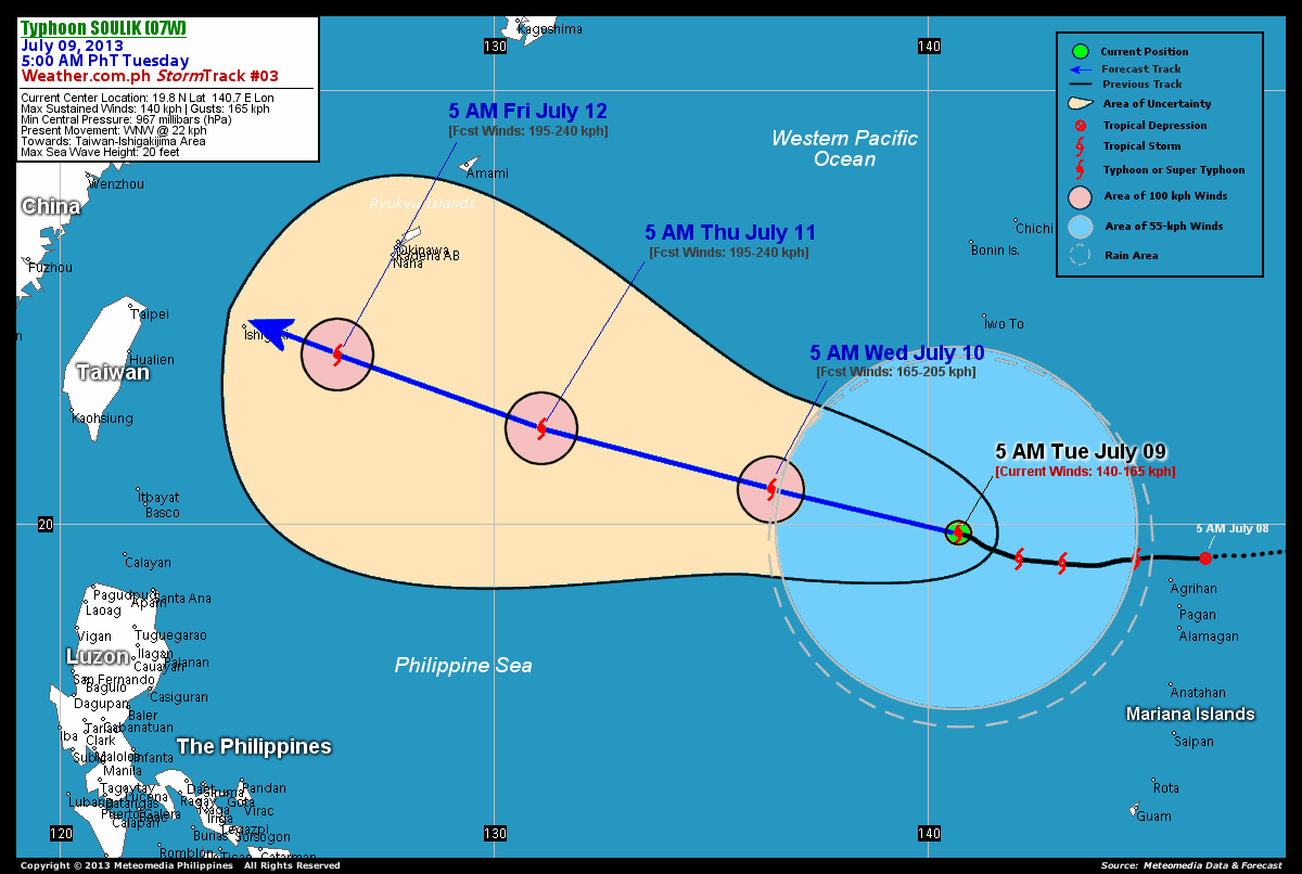
As of 5:00 am today, the eye of Typhoon Soulik (07W) was located over the open seas of the Western Pacific Ocean...about 529 km west-northwest of Agrihan Island or 1,952 km east of Basco, Batanes...currently moving west-northwest with a decreased forward speed of 22 km/hr in the general direction of Taiwan-Ishigakijima Area.
Maximum Sustained Winds (1-min. avg) have rapidly increased to 140 km/hr near the center with higher gusts. Typhoon Force Winds (118 km/hr or more) extend outward up to 65 kilometers from the center...and Tropical Storm Force Winds (62-117 km/hr) extend outward up to 165 kilometers from the center. Soulik (07W) is a very large-sized tropical cyclone with a diameter of 925 kilometers across. The 24-hour rainfall accumulation near the center of Soulik (07W) is estimated to be extreme (400 mm).
3-DAY FORECAST OUTLOOK*
Typhoon Soulik (07W) is expected to maintain its west-northwest track throughout the forecast period. On the forecast track, the core of Soulik (07W) will enter the northeastern border of the Philippine Area of Responsibility (PAR) on Wednesday morning...and will be approaching the Ishigakijima and the Yaeyama Island Chain on Friday morning.
Soulik (07W) will continue to gradually intensify within the next 12 to 24 hours, becoming a Category 2 Typhoon on Wednesday. Advance intensity forecast shows the system approaching Category 3 strength with wind speeds of 195 km/hr on Thursday through Friday.
The following is the summary of the 3-day forecast outlook on this system:
 WEDNESDAY MORNING: About to enter the northeastern border of the PAR...intensifying into a Category 2 Typhoon...about 1,080 km southeast of Okinawa, Japan [5AM JULY 10: 20.8N 136.4E @ 165kph].
THURSDAY MORNING: Becoming a major Typhoon as it nears Category 3 status...about 583 km southeast of Okinawa, Japan [5AM JULY 11: 22.2N 131.1E @ 195kph].
FRIDAY MORNING: Approaching the Yaeyama and Ishigakijima Islands...maintains its strength...about 223 km east-southeast of Ishigakijima [5AM JULY 12: 23.9N 126.4E @ 195kph].
*Please be reminded that the Forecast Outlook changes every 6 hours, and the Day 3 Forecast Track have an average error of 250 km...while the wind speed forecast error, averages 35 kph per day. Therefore, a turn to the left or right of its future track and changes in its wind speed must be anticipated from time to time.
EFFECTS & HAZARDS SUMMARY
Below is the summary of the storm's parts and its hazards affecting specific areas. You can also view this image link for you to understand the parts.
CLOUD-FILLED EYE - over water (Western Pacific Ocean). Affected Areas: None. Possible calm and lull conditions (with <20 kph winds) will be expected inside the eye (click here to know more about the EYE). EYEWALL - over water (Western Pacific Ocean). Affected Areas: None. Near-Typhoon Conditions with Typhoon Force Winds (>118 kph) will be expected within this wall (click here to know more about the Eyewall). INNER RAINBANDS - over water (Western Pacific Ocean). Affected Areas: None. Tropical Storm Conditions with Tropical Storm Force Winds (63-117 kph) will be expected along these bands. OUTER RAINBANDS - over water (Western Pacific Ocean). Affected Areas: None. Tropical Depression Conditions with light, moderate to strong winds (30-62 kph) will be expected along these bands (click here to know more about Rainbands). 24HR TOTAL RAINFALL ACCUMULATION - from 5 up to 200 mm (slight to heavy rainfall) can be expected along areas affected by the outer & inner rainbands (see above)...with isolated amounts of 201 to 400 mm (heavy to extreme) along areas near the center of Soulik (07W).
Important Note: Please keep in mind that the above forecast outlook, effects and hazards summary changes every 6 to 12 hrs!
CURRENT TECHNICAL INFORMATION
Time/Date: 5:00 AM PhT Tue July 09, 2013
Class/Name: TY Soulik (07W)
Location of Eye: 19.8º N Lat 140.7º E Lon
Distance 1: 529 km WNW of Agrihan Is., CNMI
Distance 2: 559 km SSW of Iwo To
Distance 3: 596 km E of P.A.R.
Distance 4: 736 km NW of Saipan, CNMI
Distance 5: 835 km NNW of Guam, CNMI
Distance 6: 1,513 km SE of Okinawa, Japan
Distance 7: 1,952 km E of Basco, Batanes
Distance 8: 2,044 km ESE of Taipei, Taiwan
MaxWinds (1-min avg): 140 kph near the center
Peak Wind Gusts: 165 kph
Present Movement: WNW @ 22 kph
Towards: Taiwan-Ishigakijima Area
24hr Rainfall Accum (near center): Extreme [400 mm]
Minimum Central Pressure: 967 millibars (hPa)
Size (in Diameter): 925 km [Very Large]
Max Sea Wave Height (near center): 20 feet
Possible Storm Surge Height: 4-5 ft (1.2-1.7 m)
T2K/WP StormTracks (for Public): GIF | Google Map (Flash)
 __________________________________________________________________________________________________
CURRENT NOAA/MTSAT-2 INFRARED (IR) SATELLITE IMAGE:

CURRENT TRACKING MAP:
 _____________________________________________________________________________
>> To know the meteorological terminologies and acronyms used on this update visit the ff:
http://typhoon2000.ph/tcterm.htm
http://www.nhc.noaa.gov/aboutgloss.shtml
http://www.nhc.noaa.gov/acronyms.shtml
__________________________________________________________________________________________
For the complete details on TY SOULIK (07W)...go visit our website @:
> http://www.typhoon2000.com
> http://www.maybagyo.com
<<<Typhoon2000.com Mobile >>>
Get the latest SMS Storm Alerts!
For more details: Text T2K TYPHOON to
2800 (Globe/TM) | Offline (Smart/TNT) | 2288 (Sun)
*Only P2.50 (Smart/Globe) / P2.00 (Sun) per msg received.
Click here on how to use this service (in PDF file)
Powered by: Synermaxx Corporation
Copyright © 2013 Typhoon2000.com All Rights Reserved
| Reply via web post | Reply to sender | Reply to group | Start a New Topic | Messages in this topic (1) |

No comments:
Post a Comment