
WEATHER.COM.PH TROPICAL CYCLONE UPDATES
TROPICAL DEPRESSION 08W (ISANG) UPDATE NUMBER 004
Issued: 7:00 AM PhT (23:00 GMT) Wednesday 17 July 2013
Next Update: 1:00 PM PhT (05:00 GMT) Wednesday 17 July 2013
Tropical Depression 08W (ISANG) has accelerated slightly closer to Northern Cagayan...now along the eastern coast of Cagayan...approaching Port Santa Ana.
This depression will slightly enhance the Southwest Monsoon (Hanging Habagat) and bring cloudy conditions with occasionally slight to moderate to sometimes heavy rains and thunderstorms across MiMaRoPa, Sulu Sea, and Western Panay today. Flash floods and landslides are likely in hazard-prone areas especially along mountain slopes.
Residents and visitors along Northern Luzon incl. Batanes-Calayan-Babuyan Islands, and Taiwan should closely monitor the development of 08W (Isang).
Do not use this for life or death decisions. This update is intended for additional information purposes only. Kindly refer to your national weather agency for official warnings, advisories or bulletins.
CURRENT STORM ANALYSIS
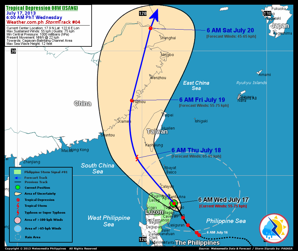
As of 6:00 am today, the center of TD 08W (Isang) was located over the east coast of Cagayan...about 80 km southeast of Santa Ana, Cagayan or 100 km east-northeast of Tuguegarao City, Cagayan...currently moving north-northwest with an increased forward speed of 22 km/hr in the general direction of Northern Cagayan-Balintang Channel Area.
Maximum Sustained Winds (1-min. avg) remain near 55 km/hr near the center with higher gusts. 08W (Isang) is a small-sized tropical cyclone with a diameter of 300 kilometers across. The 24-hour rainfall accumulation near the center of 08W (Isang) is estimated to be heavy (200 mm).
3-DAY FORECAST OUTLOOK*
TD 08W (Isang) is expected to continue moving north-northwest to northwest during the next 24 hours...turning north to north-northeast between 24 to 72 hours. On the forecast track, the core of 08W (Isang) will pass along the northeastern Cagayan this morning, passing over or very close to Port Santa Ana...and will be crossing the Balintang Channel this afternoon. On Thursday morning, 08W should be just to the west of Bashi Channel or Luzon Strait...making landfall along Fujian Province on Friday morning...and over Jiangsu Province on Saturday morning.
08W (Isang) will slightly intensify within the next 12 to 24 hours...and could become a Tropical Storm (TS) later today or Thursday. Advance Intensity Forecast (AIF) shows the system reaching winds of about 65 km/hr on Thursday morning...maintaining this strength before making landfall over Southeastern China on Friday...and weakening into a Tropical Depression (TD) through Saturday.
The following is the summary of the 3-day forecast outlook on this system:
 THURSDAY MORNING: Strengthens into a minimal TS as it moves across the West Philippine Sea, west of Bashi Channel...about 150 km south-southwest of Kaohsiung, Taiwan [6AM JULY 18: 21.4N 119.6E @ 65kph].
FRIDAY MORNING: Making landfall over Fujian Province, Southeastern China...weakens to a TD...about 15 km south-southwest of Fuzhou, China [6AM JULY 19: 26.0N 119.2E @ 55kph].
SATURDAY MORNING: Dissipating over land...or along Jiangsu Province, Eastern China...about 95 km northwest of Shanghai, China [6AM JULY 20: 31.8N 120.7E @ 45kph].
*Please be reminded that the Forecast Outlook changes every 6 hours, and the Day 3 Forecast Track have an average error of 250 km...while the wind speed forecast error, averages 35 kph per day. Therefore, a turn to the left or right of its future track and changes in its wind speed must be anticipated from time to time.
EFFECTS & HAZARDS SUMMARY
Below is the summary of the storm's parts and its hazards affecting specific areas. You can also view this image link for you to understand the parts.
DEVELOPING RAINBANDS - where Tropical Depression Conditions with light, moderate to strong winds (30-62 kph) will be expected. Affected Areas: Cagayan, Isabela, the islands of Calayan-Babuyan-Batanes, Ilocos Provinces, Aurora, Quirino, Kalinga, and Apayao. (click here to know more about Rainbands) 24HR TOTAL RAINFALL ACCUMULATION - from 5 up to 100 mm (slight to heavy rainfall) can be expected along areas affected by the outer & inner rainbands (see above)...with isolated amounts of 101 to 200 mm (heavy) along areas near the center of 08W (Isang).
Important Note: Please keep in mind that the above forecast outlook, effects and hazards summary changes every 6 to 12 hrs!
CURRENT TECHNICAL INFORMATION
Time/Date: 6:00 AM PhT Wed July 17, 2013
Class/Name: TD 08W (Isang)
Location of Center: 17.9º N Lat 122.6º E Lon
Distance 1: 80 km SE of Santa Ana, Cagayan
Distance 2: 100 km ENE of Tuguegarao City
Distance 3: 100 km NNE of Palanan, Isabela
Distance 4: 110 km SE of Aparri, Cagayan
Distance 5: 115 km NE of Ilagan City
Distance 6: 195 km SE of Calayan Island
Distance 7: 195 km NNE of Casiguran, Aurora
Distance 8: 215 km ESE of Laoag City
Distance 9: 300 km SSE of Basco, Batanes
Distance 10: 400 km NNE of Metro Manila
MaxWinds (1-min avg): 55 kph near the center
Peak Wind Gusts: 75 kph
Present Movement: NNW @ 22 kph
Towards: Northern Cagayan-Balintang Channel Area
24hr Rainfall Accum (near center): Heavy [200 mm]
Minimum Central Pressure: 1000 millibars (hPa)
Size (in Diameter): 300 km [Small]
Max Sea Wave Height (near center): 12 feet
Possible Storm Surge Height: 0 ft (0 m)
T2K/WP StormTracks (for Public): GIF | Google Map (Flash)

__________________________________________________________________________________________________
CURRENT NOAA/MTSAT-2 INFRARED (IR) SATELLITE IMAGE:

__________________________________________________________________________________________________
CURRENT TRACKING MAP:
 _____________________________________________________________________________
>> To know the meteorological terminologies and acronyms used on this update visit the ff:
http://typhoon2000.ph/tcterm.htm
http://www.nhc.noaa.gov/aboutgloss.shtml
http://www.nhc.noaa.gov/acronyms.shtml
__________________________________________________________________________________________
For the complete details on TD 08W (ISANG)...go visit our website @:
> http://www.typhoon2000.com
> http://www.maybagyo.com
<<<Typhoon2000.com Mobile >>>
Get the latest SMS Storm Alerts!
For more details: Text T2K TYPHOON to
2800 (Globe/TM) | Offline (Smart/TNT) | 2288 (Sun)
*Only P2.50 (Smart/Globe) / P2.00 (Sun) per msg received.
Click here on how to use this service (in PDF file)
Powered by: Synermaxx Corporation
Copyright © 2013 Typhoon2000.com All Rights Reserved
| Reply via web post | Reply to sender | Reply to group | Start a New Topic | Messages in this topic (1) |

No comments:
Post a Comment