
for Thursday, 28 July 2011 [11:35 AM PhT]

<<<Typhoon2000.com Mobile >>>
Get the latest 6-hrly SMS Storm Alerts on JUANING!
For more details: Text T2K TYPHOON to
2800 (Globe/TM) | 216 (Smart/TNT) | 2288 (Sun)
*Only P2.50 (Smart/Globe) / P2.00 (Sun) per msg received.
Click here on how to use this service (in PDF file)
Powered by: Synermaxx Corporation
Typhoon2000 (T2K) NEWS (Thursday July 28 2011):
Resuming the 6-hrly web, twitter and e-mail updates (except 12:00 Midnight & 3:00 AM) on NOCK-TEN (JUANING).
NOCK-TEN (JUANING) MAX WIND SPEED PER AGENCY:
+ USA (JTWC/1-min avg): 95 km/hr
+ Japan (JMA/10-min avg): 75 km/hr
+ Philippines (PAGASA/10-min avg): 95 km/hr
+ Korea (KMA/10-min avg): 95 km/hr
+ Taiwan (CWB/10-min avg): 85 km/hr
+ Beijing (NMC/2-min avg): 85 km/hr
+ Hong Kong (HKO/10-min avg): 95 km/hr
:: Click here to see Multi-Agency Forecast Tracks
TROPICAL STORM NOCK-TEN [JUANING/10W/1108]
T2K PUBLIC ADVISORY NUMBER 012
11:00 AM PhT (03:00 GMT) Thu 28 July 2011
Source: T2K Extrap Analysis/JTWC Warning #014/SatFixes
View: Advisory Archives (2004-2011)
Tropical Storm NOCK-TEN (JUANING) has quickly moved out of the Philippine Area of Responsibility (PAR)...now threatens Hainan Island. Meanwhile, TD 11W is now a Tropical Storm as it nears the PAR...not yet a threat to the Philippines.
Residents and visitors along Southern China particularly Hainan Island should closely monitor the progress of NOCK-TEN (JUANING).
Do not use this for life or death decision. This advisory is intended for additional information purposes only. Kindly refer to your country's official weather agency for local warnings, advisories & bulletins.
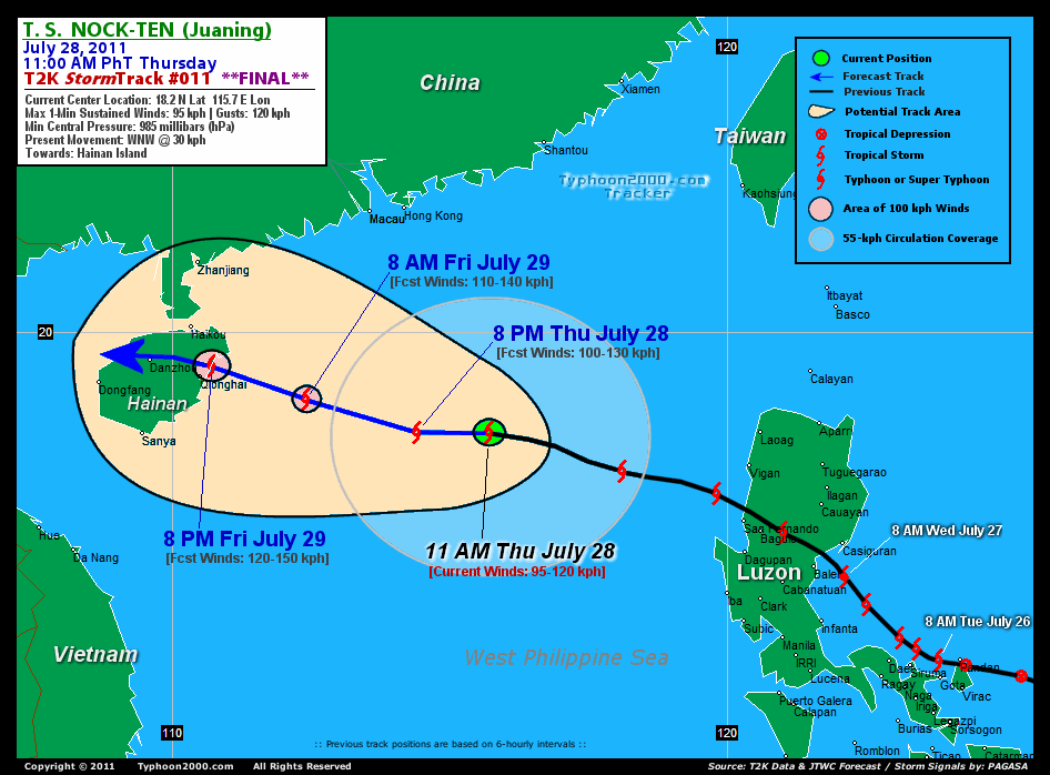
CURRENT STORM INFORMATION
Time/Date: 11:00 AM PhT Thu July 28 2011
Location of Center: 18.2º N Lat 115.7º E Lon
Distance 1: 500 km (270 nm) WNW of Vigan City
Distance 2: 520 km (280 nm) West of Laoag City
Distance 3: 470 km (255 nm) SSE of Hong Kong
Distance 4: 495 km (267 nm) SSE of Macau
Distance 5: 550 km (297 nm) ESE of Hainan Island
MaxWinds (1-min avg): 95 kph (50 kts) near the center
Peak Wind Gusts: 120 kph (65 kts)
Present Movement: WNW @ 30 kph (16 kts)
Towards: Hainan Island
24hr Rainfall Accum (near center): 200 mm (High)
Rainrate (near center): 10-20 mm/hr (Mod-Heavy)
Minimum Central Pressure: 985 millibars (hPa)
Saffir-Simpson Typhoon Scale: Tropical Storm
Size (in Diameter): 590 km (320 nm) / Average
Wind Area Distribution (in Knots): Current Wind Profile
Possible Storm Surge Height: 0-3 ft [0-0.9 m]
T2K Final TrackMap (for Public): 11:00 AM PhT Thu July 28
FORECAST OUTLOOK ANALYSIS (up to 2 days)* NOCK-TEN's (JUANING) CLOSEST POINT OF APPROACH (CPA)* EXTENDED FORECAST TRACK (3 to 5 days)* EFFECTS & HAZARDS SUMMARY TROPICAL CYCLONE WATCH CURRENT SW MONSOON INTENSITY: STRONG >> Cloudy skies with occasional showers, rains, squalls & thunderstorms will be expected along the following affected areas: PALAWAN, WESTERN VISAYAS & WESTERN LUZON. Moderate to strong SW'ly winds (not in excess of 45 kph) will blow. Important Note: Please keep in mind that the above forecast outlook, extended forecast, effects-hazards, current monsoon intensity, & tropical cyclone watch changes every 6 to 12 hrs!
NOCK-TEN (JUANING) is expected to continue moving WNW and re-intensify through the next 1-2 days while moving along the West Philippine Sea (South China Sea). It shall again become a typhoon tomorrow afternoon before making landfall over Hainan Island, China. Below is the summary of the 2-day forecast for this system.  THIS EVENING (THU): Intensifying while moving across the West Philippine Sea...about 445 km South of Hong Kong, China [8PM JUL 28: 18.2N 114.4E @ 100kph]. TOMORROW MORNING (FRI): Approaching Typhoon strength as it moves closer to the east coast of Hainan Island...about 205 km ESE of Qionghai, Hainan Island [8AM JUL 29: 18.8N 112.4E @ 110kph]. TOMORROW EVENING (FRI): Upgraded to a Typhoon...making landfall over Eastern Hainan...about 30 km NNE of Qionghai, Hainan Island [8PM JUL 29: 19.4N 110.7E @ 120kph]. SATURDAY MORNING: Downgraded to a Tropical Storm while over the western part of Hainan Island...entering the Gulf of Tonkin...about 45 km NE of Dongfang, Hainan Island [8AM JUL 30: 19.4N 109.0E @ 100kph].
Maximum Sustained Winds (1-min. avg) are near 95 km/hr (50 knots) with higher gusts. NOCK-TEN (JUANING) is a Tropical Storm (TS) on the Saffir-Simpson Tropical Cyclone Scale. Tropical Storm Force Winds (62-117 km/hr) extend outward up to 150 kilometers (80 nautical miles) from the center. NOCK-TEN is an average-sized tropical cyclone with a diameter of 590 kilometers (320 nautical miles) across. HAINAN ISLAND, CHINA: Making landfall along the Eastern Coast...About 30 km NNE of Qionghai, Hainan Island [ETA: between 7:00 PM Friday, July 29 to 9:00 AM PhT Saturday, July 30]. NORTHERN VIETNAM: Making landfall along the coast...about 220 km South of Hanoi, Vietnam [ETA: between 9:00-11:00 AM PhT Sunday, July 31]. SUNDAY EARLY MORNING: Downgraded into a Tropical Storm while moving across the Gulf of Tonkin...makes landfall over Northern Vietnam [2AM JUL 31: 19.7N 106.5E @ 100kph]. MONDAY EARLY MORNING: Downgraded into a TD as it rapidly dissipates while over Laos [2AM AUG 01: 20.0N 103.3E @ 45kph]. TUESDAY EARLY MORNING: Dissipated along the Thailand-Laos-Chinese Border [2AM AUG 02: 21.5N 101.1E @ 35kph].
*Please be reminded that the Forecast Outlook changes every 6 hours, and the Extended Forecast Track have an average error of 250 km on Day 3...450 km on Day 4...and 650 km on Day 5, while the wind speed forecast error, averages 35 kph per day. Therefore, a turn to the left or right of its future track and changes in its wind speed must be anticipated from time to time.
NOCK-TEN's (JUANING) circulation slightly disorganized as it moves faster across the Western Philippine Sea (South China Sea). Its main rainbands has moved back to the open sea. Below is the summary of the storm's parts and its hazards affecting specific areas: INNER RAINBANDS - over water (West Philippine Sea)...not affecting any land areas. Tropical Storm Conditions w/ Tropical Storm Force Winds (62-117 kph) will be expected along these bands. OUTER RAINBANDS - spreading & affecting Western Luzon including the islands of Batanes-Calayan-Babuyan.. Tropical Depression Conditions w/ moderate to strong winds (25-61 kph) will be expected along these bands (click here to know more about Rainbands). 24HR TOTAL RAINFALL ACCUMULATION - from 5 up to 100 mm (low to high rainfall) can be expected along the outer & inner rainbands...with isolated amounts of up to 200 mm (high) near the center of NOCK-TEN (JUANING). (click to open NOAA's eTRaP graphic).
Tropical Storm 11W (UNNAMED) upgraded from a Tropical Depression...accelerating WNW-ward closer to the Philippine Area of Responsibility (PAR). The center was located near lat 13.3N lon 136.6E...about 1320 km East of Bicol Region...with 1-min maximum sustained winds of 65 kph near the center...moving WNW @ 28 kph. View the latest satellite flash loop on this cyclone.
JTWC (US NAVY & AIR FORCE) REMARKS:
REMARKS (for Meteorologists): 8 AM (00 GMT) THU 28 JULY POSITION: 17.8N 116.5E.
*TROPICAL STORM 10W (NOCK-TEN), LOCATED APPROXIMATELY 310 NM
WEST-NORTHWEST OF MANILA, PHILIPPINES, HAS TRACKED WESTWARD AT 16
KNOTS OVER THE PAST SIX HOURS. ANIMATED MULTISPECTRAL SATELLITE
IMAGERY SHOWS CONSOLIDATING CENTRAL CONVECTION AROUND THE LOW LEVEL
CIRCULATION CENTER (LLCC) WITH INCREASED CONVECTION IN THE LARGER
BAND TO THE SOUTH. A 272213Z SSMIS 91H GHZ IMAGE SHOWS THE LARGE
CONVECTIVE FEEDER BAND TO THE SOUTH OF THE LLCC ALONG WITH TWO
FRAGMENTED CONCENTRIC RINGS OF CONVECTION ALONG THE PERIPHERY OF
THE LLCC. THE COLOR COMPOSITE OF THIS IMAGE SHOWS THAT SMALLER RAIN
BANDS ARE WRAPPING INTO THE LLCC FROM THE WEST AND NORTHEAST. UPPER
LEVEL ANALYSIS INDICATES THAT TS 10W IS IN AN AREA OF WEAK (05-10
KNOT)NORTHEASTERLY VERTICAL WIND SHEAR WITH GOOD DIVERGENCE ALOFT.
THE EQUATORWARD OUTFLOW REMAINS EXCELLENT AND THE POLEWARD OUTFLOW
CHANNEL INTO A TROPICAL UPPER TROPOSPHERIC TROUGH (TUTT) CELL TO THE
NORTHEAST REMAINS INTACT AS THE TUTT CELL PROPAGATES WESTWARD,
THEREBY MAINTAINING PROXIMITY TO THE STORM. THE INITIAL POSITION IS
BASED ON THE AFOREMENTIONED MICROWAVE IMAGE ALONG WITH A 280026Z
TRMM 85 GHZ PASS WITH GOOD CONFIDENCE. THE INITIAL INTENSITY IS
SLIGHTLY HIGHER THAN THE PGTW DVORAK INTENSITY ESTIMATE OF
45 KNOTS...(more info)
>> NOCK-TEN, meaning: Bird. Name contributed by: Laos.
_______________________________________________________________________________________________________________________________________
RECENT TYPHOON2000.COM (JTWC) TRACKING CHART:
_________________________________________________________________________________________________________________
RECENT MULTI-AGENCY TROPICAL CYCLONE FORECAST TRACKING CHART: 
_________________________________________________________________________________________________________________

> Image source: NOAA SATELLITE CENTER: http://www.ssd.noaa.gov/mtsat/flt/t1/rgb.jpg
> Image source: Wunderground.com Tropical Page (http://www.wunderground.com/tropical)
____________________________________________________________________________________________________________________
LATEST 24HR. TOTAL RAINFALL AMOUNTS / ENSEMBLE TROPICAL RAINFALL POTENTIAL (eTRaP):

> Image source: NOAA Satellite & Information Service (http://www.ssd.noaa.gov/PS/TROP/etrap.html)
>> To know the meteorological terminologies and acronyms used on this update visit the ff:
http://typhoon2000.ph/tcterm.htm
http://www.nhc.noaa.gov/aboutgloss.shtml
http://www.srh.noaa.gov/oun/severewx/glossary.php
http://www.srh.weather.gov/fwd/glossarynation.html
http://www.nhc.noaa.gov/acronyms.shtml
__________________________________________________________________________________________
For the complete details on TS NOCK-TEN (JUANING)...go visit our website @:
> http://www.typhoon2000.com
> http://www.maybagyo.com
Copyright © 2011 Typhoon2000.com All Rights Reserved

No comments:
Post a Comment