
for Tuesday, 26 July 2011 [12:45 PM PhT]

<<<Typhoon2000.com Mobile >>>
Get the latest 3-hrly SMS Storm Alerts on JUANING!
For more details: Text T2K TYPHOON to
2800 (Globe/TM) | 216 (Smart/TNT) | 2288 (Sun)
*Only P2.50 (Smart/Globe) / P2.00 (Sun) per msg received.
Click here on how to use this service (in PDF file)
Powered by: Synermaxx Corporation
Typhoon2000 (T2K) NEWS (Tuesday July 26 2011):
Currently issuing 3-hrly web, twitter and e-mail updates (except 12:00 Midnight & 3:00 AM) on NOCK-TEN (JUANING).
NOCK-TEN (JUANING) MAX WIND SPEED PER AGENCY:
+ USA (JTWC/1-min avg): 65 km/hr
+ Japan (JMA/10-min avg): 65 km/hr
+ Philippines (PAGASA/10-min avg): 65 km/hr
+ Korea (KMA/10-min avg): 65 km/hr
+ Taiwan (CWB/10-min avg): 65 km/hr
+ Beijing (NMC/2-min avg): 65 km/hr
+ Hong Kong (HKO/10-min avg): 55 km/hr
:: Click here to see Multi-Agency Forecast Tracks
TROPICAL STORM NOCK-TEN [JUANING/10W/1108]
T2K PUBLIC ADVISORY NUMBER 005
12:00 PM PhT (04:00 GMT) Tue 26 July 2011
Source: T2K Extrap Analysis/JTWC Warning #006/SatFixes
View: Advisory Archives (2004-2011)
Tropical Storm NOCK-TEN (JUANING) has slowed down and moved Westward while passing along the Northern Coast of Camarines Sur. Its inner rainbands continues to spread across the Bicol Region especially along Camarines Provinces & Catanduanes.
At 12:00 PM Local Time, Typhoon2000 Automated Weather Station in Naga City (13.6N 123.2E) has recorded wind gust of 31 kph blowing from the West, with barometric pressure of 994.7 millibars & 36-hr. Rainfall Accumulation of 230 mm.
Residents and visitors along the Bicol Region & Eastern Luzon should closely monitor the progress of NOCK-TEN (JUANING).
Do not use this for life or death decision. This advisory is intended for additional information purposes only. Kindly refer to your country's official weather agency for local warnings, advisories & bulletins.
CURRENT STORM INFORMATION FORECAST OUTLOOK ANALYSIS (up to 2 days)* NOCK-TEN's (JUANING) CLOSEST POINT OF APPROACH (CPA)* EXTENDED FORECAST TRACK (3 to 5 days)* EFFECTS & HAZARDS SUMMARY TROPICAL CYCLONE WATCH CURRENT SW MONSOON INTENSITY: STRONG >> Cloudy skies with occasional showers, rains, squalls & thunderstorms will be expected along the following affected areas: PALAWAN, CALAMIAN GROUP, MINDORO, MARINDUQUE, & THE REST OF VISAYAS. Light to moderate SW'ly winds (not in excess of 60 kph) will blow. Important Note: Please keep in mind that the above forecast outlook, extended forecast, effects-hazards, current monsoon intensity, & tropical cyclone watch changes every 6 to 12 hrs! PHILIPPINE STORM WARNING SIGNAL # TWO (2) The above areas will experience stormy weather - where winds of 60-100 kph can be expected. Coastal waters will be rough to very rough and extremely dangerous to all types of seacrafts. PHILIPPINE STORM WARNING SIGNAL # ONE (1) The above areas will have rains and winds of not more than 60 kph today & tomorrow. Coastal waters will be moderate to rough.
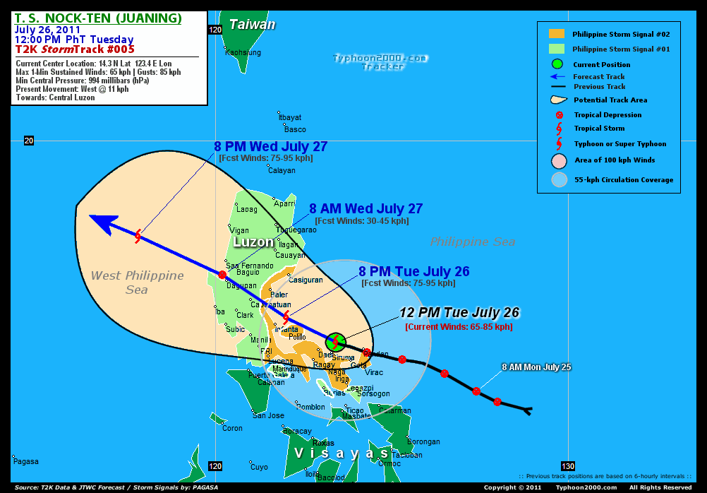
Time/Date: 12:00 PM PhT Tue July 26 2011
Location of Center: 14.3º N Lat 123.4º E Lon {Relocated}
Distance 1: 35 km (19 nm) North of Siruma, CamSur
Distance 2: 60 km (32 nm) ENE of Daet, CamNorte
Distance 3: 70 km (38 nm) NW of Caramoan, CamSur
Distance 4: 90 km (48 nm) WNW of Pandan, Catanduanes
Distance 5: 80 km (43 nm) NNE of Metro Naga/CWC
Distance 6: 100 km (55 nm) North of Iriga City
Distance 7: 130 km (70 nm) NW of Virac, Catanduanes
Distance 8: 125 km (67 nm) NNW of Legazpi City
Distance 9: 190 km (103 nm) ESE of Infanta, Quezon
Distance 10: 260 km (140 nm) East of Metro Manila
MaxWinds (1-min avg): 65 kph (35 kts) near the center
Peak Wind Gusts: 85 kph (45 kts)
Present Movement: West @ 11 kph (06 kts)
Towards: Northern Quezon-Aurora Area
CPA [ETA] to Aurora: Wed Evening [11 PM-12M PhT]
24hr Rainfall Accum (near center): 320 mm (High)
Minimum Central Pressure: 993 millibars (hPa)
Saffir-Simpson Typhoon Scale: Tropical Storm
Size (in Diameter): 480 km (260 nm) / Average
Wind Area Distribution (in Knots): Current Wind Profile
Possible Storm Surge Height: 0 ft [0 m]
T2K TrackMap (for Public): 12:00 PM PhT Tue July 26
NOCK-TEN (JUANING) is expected to turn WNW-ward into Central Luzon & across the South China Sea within the next 2 days. It shall weaken upon traversing the mountain ranges of Sierra Madre and Cordillera. Below is the summary of the 2-day forecast for this system.  THIS EVENING (TUE): Still intensifying as it approaches the coast of Aurora....about 45 km SSE of Casiguran, Aurora [8PM JUL 26: 15.0N 122.0E @ 75kph]. This system is expected to make landfall between Baler & Infanta around midnight (between 11 PM-1 AM)...and cross Nueva Ecija-Pangasinan overnight. TOMORROW MORNING (WED): Weakened rapidly into a Low Pressure upon crossing Central Luzon...in the vicinity of Lingayen Gulf...about 25 km NW of Dagupan City [8AM JUL 27: 16.2N 120.2E @ 30kph]. TOMORROW EVENING (WED): Regains Tropical Storm strength as it moves away from Western Luzon, across the West Philippine Sea (South China Sea)...about 280 km WSW of Vigan City, Ilocos Sur [8PM JUL 27: 17.3N 117.8E @ 75kph]. THURSDAY MORNING: Gaining strength while over the South China Sea...about 500 km ESE of Hainan Island, China [8AM JUL 28: 18.2N 115.3E @ 95kph].
Maximum Sustained Winds (1-min. avg) are near 65 km/hr (35 knots) with higher gusts. NOCK-TEN (JUANING) is a Tropical Storm (TD) on the Saffir-Simpson Tropical Cyclone Scale. NOCK-TEN is an average-sized tropical cyclone with a diameter of 480 kilometers (260 nautical miles) across. SOUTHERN AURORA-NORTHERN QUEZON: Making landfall in between Baler and Infanta...about 65 km NNW of Infanta, Quezon [ETA: between 11:00 PM-12:00 AM PhT Tonight]. FRIDAY MORNING: Approaching the east coast of Hainan Island [8AM JUL 29: 19.7N 111.8E @ 95kph]. SATURDAY MORNING: Moving into the Gulf of Tonkin, or off the Southern Coast of Northern Vietnam...weakens [8AM JUL 30: 20.6N 108.4E @ 75kph]. SUNDAY MORNING: Dissipating into an area of Low Pressure over land, after making landfall over Northern Vietnam...passing very near Hanoi City [8AM JUL 31: 20.4N 105.6E @ 30kph].
**Alternate Forecast Scenario (AFS): There is a possibility that NOCK-TEN will continue moving Westward and cross Central Luzon tonight...making landfall near Infanta, Quezon and passing north of Metro Manila - if the strong High Pressure Steering Ridge NE of the storm will not giveway.
*Please be reminded that the Forecast Outlook changes every 6 hours, and the Extended Forecast Track have an average error of 250 km on Day 3...450 km on Day 4...and 650 km on Day 5, while the wind speed forecast error, averages 35 kph per day. Therefore, a turn to the left or right of its future track and changes in its wind speed must be anticipated from time to time.
NOCK-TEN's (JUANING) circulation being affected by the land terrain of Bicol Peninsula...trying to re-organize with most of its thick convective rainbands along the southern portion of the Low-Level Circulation Center (LLCC). Below is the summary of the storm's parts and its hazards affecting specific areas: INNER RAINBANDS - spreading & affecting Bicol Region except Masbate. Tropical Storm Conditions w/ Tropical Storm Force Winds (62-85 kph) can be expected along these bands. OUTER RAINBANDS - spreading & affecting parts of Luzon including Metro Manila, Northern Samar, Masbate, & Southern Tagalog Provinces. Tropical Depression Conditions w/ moderate to strong winds (10-61 kph) can be expected along these bands (click here to know more about Rainbands). 24HR TOTAL RAINFALL ACCUMULATION - from 5 up to 150 mm (low to high rainfall) can be expected along the outer & inner rainbands...with isolated amounts of up to 320 mm (high) near the center of MA-ON (INENG), especially along the southern & western portions. (click to open NOAA's eTRaP graphic).
Tropical Depression 11W (UNNAMED) continues to move WNW into the Caroline Islands...may reach Tropical Storm status later today. Its possible center was located near lat 6.4N lon 143.9E...about 785 km South of Guam, CNMI...with 1-min maximum sustained winds of 55 kph near the center. View the latest satellite flash loop on this disturbance. ![]()
PAGASA Philippine Storm Warnings Signals 
Now In Effect: CATANDUANES, ALBAY, & CAMARINES NORTE, CAMARINES SUR, QUEZON, POLILLO ISLANDS, & AURORA.
In Effect: SORSOGON, BURIAS ISLAND, MARINDUQUE, THE REST OF LUZON INCLUDING METRO MANILA.
Residents living in low-lying and mountainous areas under Public Storm Warning Signal Number 1 are alerted against flashfloods, mudslides and landslides.
REMARKS (for Meteorologists): 8 AM (00 GMT) TUE 26 JULY POSITION: 14.1N 123.4E.
*TROPICAL STORM (TS) 10W, LOCATED APPROXIMATELY 150 NM EAST-
SOUTHEAST OF MANILA, PHILIPPINES, HAS TRACKED WESTWARD AT 09 KNOTS
OVER THE PAST SIX HOURS. THE SYSTEM HAS MADE A SIGNIFICANT BEND
SOUTH OF THE EXPECTED TRACK DURING THE PAST 12 HOURS DUE TO A STRONG
UPPER LEVEL RIDGE TO THE NORTHEAST OF LUZON. SURFACE REPORTS FROM
THE CATANDUANES RADAR SITE CONFIRM THAT THE LOW LEVEL CIRCULATION
CENTER PASSED NORTH OF THE SITE. RECENT ANIMATED MULTISPECTRAL
SATELLITE IMAGERY SHOWS SOME INTENSIFICATION IN CONVECTION AROUND
THE LOW LEVEL CIRCULATION CENTER (LLCC). A 252043Z SSMIS IMAGE SHOWS
CLEAR ORGANIZATION AROUND THE LLCC, BUT THE MAJORITY OF DEEP
CONVECTION IS ASSOCIATED WITH LAND INTERACTION ON THE PERIPHERY OF
THE SYSTEM. TS 10W IS STILL STRUGGLING TO INTENSIFY AGAINST THE
EFFECTS OF STRONG SUBSIDENCE OVER THE NORTHERN SEMICIRCLE. ANIMATED
WATER VAPOR IMAGERY REVEALS THE SEVERE DEGREE OF SUPPRESSION TO
POLEWARD OUTFLOW. EQUATORWARD OUTFLOW REMAINS WELL ESTABLISHED,
HOWEVER, AND NET VERTICAL WIND SHEAR OVER THE SYSTEM REMAINS AT
APPROXIMATELY 15 KNOTS. A 252043Z 37 GHZ SSMIS IMAGE CONFIRMS
SIGNIFICANTLY BETTER ORGANIZATION IN THE LOW LEVEL BANDING, BUT THE
91 GHZ IMAGE SHOWS THAT THE VAST MAJORITY OF DEEP CONVECTION IS
ASSOCIATED WITH LAND INTERACTION. EARLIER ASCAT IMAGERY CONFIRMED
BROAD SWATHS OF 25-30 KNOT WINDS EXTENDING OVER 100 NM AWAY FROM THE
LLCC. SURFACE REPORTS FROM COASTAL STATIONS IN COASTAL SAMAR AND
LUZON SHOW OFF-SHORE WINDS RISING AND PRESSURES FALLING. THE CURRENT
INTENSITY ESTIMATE IS BASED ON DVORAK ANALYSES OF 35 KNOTS FROM KNES
AND PGTW...(more info)
>> NOCK-TEN, meaning: Bird. Name contributed by: Laos.
_______________________________________________________________________________________________________________________________________
RECENT TYPHOON2000.COM (JTWC) TRACKING CHART:
_________________________________________________________________________________________________________________
RECENT MULTI-AGENCY TROPICAL CYCLONE FORECAST TRACKING CHART: 

> Image source: NOAA SATELLITE CENTER: http://www.ssd.noaa.gov/mtsat/flt/t1/rgb.jpg
> Image source: Wunderground.com Tropical Page (http://www.wunderground.com/tropical)
____________________________________________________________________________________________________________________
LATEST 24HR. TOTAL RAINFALL AMOUNTS / ENSEMBLE TROPICAL RAINFALL POTENTIAL (eTRaP):

> Image source: NOAA Satellite & Information Service (http://www.ssd.noaa.gov/PS/TROP/etrap.html)
>> To know the meteorological terminologies and acronyms used on this update visit the ff:
http://typhoon2000.ph/tcterm.htm
http://www.nhc.noaa.gov/aboutgloss.shtml
http://www.srh.noaa.gov/oun/severewx/glossary.php
http://www.srh.weather.gov/fwd/glossarynation.html
http://www.nhc.noaa.gov/acronyms.shtml
__________________________________________________________________________________________
For the complete details on TS NOCK-TEN (JUANING)...go visit our website @:
> http://www.typhoon2000.com
> http://www.maybagyo.com
Copyright © 2011 Typhoon2000.com All Rights Reserved

No comments:
Post a Comment