
for Tuesday, 26 July 2011 [6:45 AM PhT]

<<<Typhoon2000.com Mobile >>>
Get the latest 3-hrly SMS Storm Alerts on JUANING!
For more details: Text T2K TYPHOON to
2800 (Globe/TM) | 216 (Smart/TNT) | 2288 (Sun)
*Only P2.50 (Smart/Globe) / P2.00 (Sun) per msg received.
Click here on how to use this service (in PDF file)
Powered by: Synermaxx Corporation
Typhoon2000 (T2K) NEWS (Monday July 25 2011):
Now initiating the 3-hrly web, twitter and e-mail updates (except 12:00 Midnight & 3:00 AM) on 10W (JUANING).
10W (JUANING) MAX WIND SPEED PER AGENCY:
+ USA (JTWC/1-min avg): 55 km/hr
+ Japan (JMA/10-min avg): 55 km/hr
+ Philippines (PAGASA/10-min avg): 55 km/hr
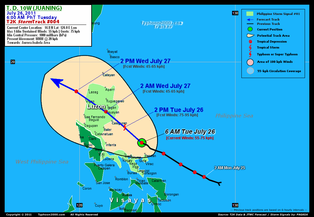
TROPICAL DEPRESSION 10W [JUANING]
T2K PUBLIC ADVISORY NUMBER 004
6:00 AM PhT (22:00 GMT) Tue 26 July 2011
Source: T2K Extrap Analysis/JTWC Warning #005/SatFixes
View: Advisory Archives (2004-2011)
Tropical Depression 10W (JUANING) has changed its course to the WNW and is now passing to the north of Catanduanes...nearing Tropical Storm status. Its inner rainbands continues to spread across the Bicol Region.
At 6:30 AM Local Time, Typhoon2000 Automated Weather Station in Naga City (13.6N 123.2E) has recorded wind gust of 34 kph blowing from the West, with barometric pressure of 994.2 millibars & 30-hr. Rainfall Accumulation of 220 mm.
Residents and visitors along the Bicol Region & Eastern Luzon should closely monitor the progress of 10W (JUANING).
Do not use this for life or death decision. This advisory is intended for additional information purposes only. Kindly refer to your country's official weather agency for local warnings, advisories & bulletins.
CURRENT STORM INFORMATION
Time/Date: 6:00 AM PhT Mon July 25 2011
Location of Center: 14.8º N Lat 124.0º E Lon
Distance 1: 80 km (43 nm) NNW of Pandan, Catanduanes
Distance 2: 115 km (63 nm) North of Caramoan, CamSur
Distance 3: 115 km (63 nm) NE of Siruma, CamSur
Distance 4: 140 km (75 nm) ENE of Daet, CamNorte
Distance 5: 160 km (85 nm) NNE of Metro Naga/CWC
Distance 6: 170 km (92 nm) NNE of Iriga City
Distance 7: 190 km (103 nm) NNE of Legazpi City
Distance 8: 245 km (132 nm) East of Infanta, Quezon
Distance 9: 255 km (137 nm) SE of Casiguran, Aurora
Distance 10: 325 km (175 nm) East of Metro Manila
Distance 11: 150 km (80 nm) NNW of Virac, Catanduanes
MaxWinds (1-min avg): 55 kph (30 kts) near the center
Peak Wind Gusts: 75 kph (40 kts)
Present Movement: WNW @ 20 kph (11 kts)
Towards: Isabela-Cagayan Area
CPA [ETA] to Aurora: Wed Evening [7-8PM PhT]
24hr Rainfall Accum (near center): 320 mm (High)
Minimum Central Pressure: 1000 millibars (hPa)
Saffir-Simpson Typhoon Scale: Tropical Depression
Size (in Diameter): ... km (... nm) / N/A
Wind Area Distribution (in Knots): Current Wind Profile
Possible Storm Surge Height: 0 ft [0 m]
T2K TrackMap (for Public): 6:00 AM PhT Tue July 26
FORECAST OUTLOOK ANALYSIS (up to 2 days)* 10W's (JUANING) CLOSEST POINT OF APPROACH (CPA)* EXTENDED FORECAST TRACK (3 to 5 days)* EFFECTS & HAZARDS SUMMARY TROPICAL CYCLONE WATCH CURRENT SW MONSOON INTENSITY: STRONG >> Cloudy skies with occasional showers, rains, squalls & thunderstorms will be expected along the following affected areas: PALAWAN, CALAMIAN GROUP, MINDORO, MARINDUQUE, & THE REST OF VISAYAS. Light to moderate SW'ly winds (not in excess of 45 kph) will blow. Important Note: Please keep in mind that the above forecast outlook, extended forecast, effects-hazards, current monsoon intensity, & tropical cyclone watch changes every 6 to 12 hrs! PHILIPPINE STORM WARNING SIGNAL # ONE (1) The above areas will have rains and winds of not more than 60 kph today. Coastal waters will be moderate to rough.
10W (JUANING) is now expected to take the alternate scenario...tracking it into Northern Luzon within the next 2 days. It shall become a Tropical Storm (TS) before landfall. Below is the summary of the 2-day forecast for this system.  THIS AFTERNOON (TUE): Upgraded to a Tropical Storm (TS) as it approaches the coast of Aurora....about 95 km SE of Casiguran, Aurora [2PM JUL 26: 15.8N 122.9E @ 75kph]. This system is expected to make landfall near Casiguran tonight (between 8-9 PM tonight) TOMORROW EARLY MORNING (WED): Crossing Northern Luzon as a weakened Tropical Depression (TD)...in the vicinity of Isabela Province...about 10 km SSE of Cauayan, Isabela [2AM JUL 27: 16.8N 121.7E @ 45kph]. TOMORROW AFTERNOON (WED): Exits Northern Luzon via Ilocos Provinces...just off the coast of Ilocos or over the West Philippine Sea (South China Sea)...about 85 km WSW of Laoag City, Ilocos Norte [2PM JUL 27: 18.1N 119.8E @ 45kph]. THURSDAY EARLY MORNING: Re-intensifies into a Tropical Storm...accelerating WNW across the West Philippine Sea (South China Sea), towards Southern China...about 375 km WNW of Laoag City [2AM JUL 28: 19.2N 117.1E @ 95kph].
Maximum Sustained Winds (1-min. avg) are near 55 km/hr (30 knots) with higher gusts. 10W (JUANING) is a Tropical Depression (TD) on the Saffir-Simpson Tropical Cyclone Scale. CATANDUANES: About 70 km North of Pandan. Catanduanes [ETA: Ongoing]. AURORA: Making landfall in the vicinity of NE Aurora...about 15 km NE of Casiguran, Aurora [ETA: between 7:00-8:00 PM PhT Tonight]. FRIDAY EARLY MORNING: Regains strength while passing to the south of Hong Kong...approaching the coast of Western Guangdong, China [2AM JUL 29: 20.4N 112.8E @ 95kph]. SATURDAY EARLY MORNING: Moving into the Gulf of Tonkin, or off the Southern Coast of Northern Vietnam...weakens [2AM JUL 30: 21.0N 108.4E @ 75kph]. SUNDAY EARLY MORNING: Dissipating into an area of Low Pressure over land, after making landfall over Northern Vietnam [2AM JUL 31: 20.8N 104.8E @ 30kph].
*Please be reminded that the Forecast Outlook changes every 6 hours, and the Extended Forecast Track have an average error of 250 km on Day 3...450 km on Day 4...and 650 km on Day 5, while the wind speed forecast error, averages 35 kph per day. Therefore, a turn to the left or right of its future track and changes in its wind speed must be anticipated from time to time.
10W's (JUANING) circulation continues to organize with most of its thick convective rainbands along the western & southern portions of the Low-Level Circulation Center (LLCC). Below is the summary of the storm's parts and its hazards affecting specific areas: INNER RAINBANDS - spreading & affecting Bicol Region except Masbate. Tropical Depression Conditions w/ Tropical Depression Force Winds (31-60 kph) can be expected along these bands. OUTER RAINBANDS - spreading & affecting parts of Luzon including Metro Manila, Northern Samar, Masbate, & Southern Tagalog Provinces. Near-Tropical Depression Conditions w/ light to moderate winds (5-30 kph) can be expected along these bands (click here to know more about Rainbands). 24HR TOTAL RAINFALL ACCUMULATION - from 5 up to 150 mm (low to high rainfall) can be expected along the outer & inner rainbands...with isolated amounts of up to 320 mm (high) near the center of MA-ON (INENG), especially along the southern & western portions. (click to open NOAA's eTRaP graphic).
Tropical Depression 11W (UNNAMED) has accelerated WNW into the Caroline Islands...continues to intensify. Its possible center was located near lat 6.0N lon 145.1E...about 825 km South of Guam, CNMI...with 1-min maximum sustained winds of 55 kph near the center. View the latest satellite flash loop on this disturbance. ![]()
PAGASA Philippine Storm Warnings Signals 
In Effect: ILOCOS PROVINCES, ABRA, APAYAO, KALINGA, CAGAYAN, ISABELA, IFUGAO, MT. PROVINCE, LA UNION, PANGASINAN, BENGUET, NUEVA VIZCAYA, NUEVA ECIJA, QUIRINO, AURORA, QUEZON, POLILLO ISLANDS, CATANDUANES, CAMARINES PROVINCES, ALBAY, & SORSOGON.
Residents living in low-lying and mountainous areas under Public Storm Warning Signal Number 1 are alerted against flashfloods, mudslides and landslides.
REMARKS (for Meteorologists): 2 AM (186 GMT) TUE 26 JULY POSITION: 14.7N 124.4E.
*TROPICAL DEPRESSION 10W, LOCATED APPROXIMATELY 200 NM EAST OF
MANILA, PHILIPPINES, HAS TRACKED NORTHWESTWARD AT 13 KNOTS OVER THE
PAST SIX HOURS. ANIMATED INFRARED SATELLITE IMAGERY (MSI) SHOWS 10W
IS STILL STRUGGLING TO INTENSIFY AGAINST THE EFFECTS OF STRONG
SUBSIDENCE OVER THE NORTHERN SEMICIRCLE. ANIMATED WATER VAPOR
IMAGERY REVEALS THE SEVERE DEGREE OF SUPPRESSION ON POLEWARD
OUTFLOW. EQUATORWARD OUTFLOW REMAINS WELL ESTABLISHED, HOWEVER, AND
NET VERTICAL WIND SHEAR OVER THE SYSTEM REMAINS AT APPROXIMATELY 15
KNOTS. TWO CONSECUTIVE PARTIAL ASCAT PASSES (250151Z AND 251256Z) DO
REVEAL SOME DEVELOPMENT RELATIVE TO THE PREVIOUS DAY. BOTH SHOW
BROAD FIELDS OF 20-30 KNOT WINDS OVER THE NORTHERN SEMICIRCLE. A
251143Z SSMIS IMAGE ALSO SHOWS SIGNIFICANTLY BETTER ORGANIZATION IN
THE LOW LEVEL BANDING. THE 91GHZ IMAGE REVEALS THAT THE DEEP
CONVECTION IS CONFINED TO THE SOUTHERN SEMICIRCLE, THE COMBINED
EFFECT OF NORTHEASTERLY SHEAR AND SUBSIDENCE OVER THE NORTHERN
SEMICIRCLE. THE CURRENT INTENSITY ANALYSIS IS BASED ON A DVORAK
ASSESSMENT OF 30 KNOTS FROM PGTW, THE ASCAT IMAGERY, AND SEVERAL
SURFACE REPORTS FROM COASTAL STATIONS IN COASTAL SAMAR AND LUZON.
SEVERAL STATIONS ARE SHOWING RISING WESTERLIES AND FALLING PRESSURES
THAT EXTRAPOLATE TO A SYSTEM INTENSITY OF 1000 MB AND 30 KNOTS.
GUIDANCE HAS STABILIZED AND IS COMING INTO MUCH BETTER ALIGNMENT
REGARDING A TRACK ACROSS NORTHERN LUZON RATHER THAN THROUGH THE
LUZON STRAIT. JTWC HAS BROUGHT THE FORECAST TRACK EQUATORWARD,
STAYING JUST NORTH OF CONSENSUS. THE TRACK ADJUSTMENT RESULTS IN
GREATER SYSTEM DEGRADATION DURING THE TRACK ACROSS LUZON (TAU 18
THROUGH 30), A LONGER TRAJECTORY OVER THE SOUTH CHINA SEA, AND
GREATER CLEARANCE ON HONG KONG. THE INTENSITY FORECAST HAS ALSO BEEN
ADJUSTED TO REFLECT A PEAK INTENSITY AT TAU 72, AS INTENSITY
GUIDANCE IS NOT HANDLING THE LAND INTERACTION EFFECTIVELY. TD 10W
WILL WEAKEN SIGNIFICANTLY AS IT TRACKS ACROSS LUZON AND TAKE SOME
TIME TO RE-GATHER STRENGTH ONCE IT ENTERS THE SOUTH CHINA SEA. IN
THE EXTENDED RANGE, THE EFFECTS OF INCREASED SHEAR AND LAND
INTERACTION WILL ACT TO WEAKEN THE STORM BEFORE IT MAKES
LANDFALL...(more info)
_______________________________________________________________________________________________________________________________________
RECENT TYPHOON2000.COM (JTWC) TRACKING CHART:
_________________________________________________________________________________________________________________
RECENT MULTI-AGENCY TROPICAL CYCLONE FORECAST TRACKING CHART:
**NOT YET AVAILABLE**

> Image source: NOAA SATELLITE CENTER: http://www.ssd.noaa.gov/mtsat/flt/t1/rgb.jpg
> Image source: Wunderground.com Tropical Page (http://www.wunderground.com/tropical)
____________________________________________________________________________________________________________________
LATEST 24HR. TOTAL RAINFALL AMOUNTS / ENSEMBLE TROPICAL RAINFALL POTENTIAL (eTRaP):

> Image source: NOAA Satellite & Information Service (http://www.ssd.noaa.gov/PS/TROP/etrap.html)
>> To know the meteorological terminologies and acronyms used on this update visit the ff:
http://typhoon2000.ph/tcterm.htm
http://www.nhc.noaa.gov/aboutgloss.shtml
http://www.srh.noaa.gov/oun/severewx/glossary.php
http://www.srh.weather.gov/fwd/glossarynation.html
http://www.nhc.noaa.gov/acronyms.shtml
__________________________________________________________________________________________
For the complete details on TD 10W (JUANING)...go visit our website @:
> http://www.typhoon2000.com
> http://www.maybagyo.com
Copyright © 2011 Typhoon2000.com All Rights Reserved

No comments:
Post a Comment