
for Tuesday, 26 July 2011 [6:12 PM PhT]

<<<Typhoon2000.com Mobile >>>
Get the latest 3-hrly SMS Storm Alerts on JUANING!
For more details: Text T2K TYPHOON to
2800 (Globe/TM) | 216 (Smart/TNT) | 2288 (Sun)
*Only P2.50 (Smart/Globe) / P2.00 (Sun) per msg received.
Click here on how to use this service (in PDF file)
Powered by: Synermaxx Corporation
Typhoon2000 (T2K) NEWS (Tuesday July 26 2011):
Currently issuing 3-hrly web, twitter and e-mail updates (except 12:00 Midnight & 3:00 AM) on NOCK-TEN (JUANING).
NOCK-TEN (JUANING) MAX WIND SPEED PER AGENCY:
+ USA (JTWC/1-min avg): 65 km/hr
+ Japan (JMA/10-min avg): 75 km/hr
+ Philippines (PAGASA/10-min avg): 75 km/hr
+ Korea (KMA/10-min avg): 70 km/hr
+ Taiwan (CWB/10-min avg): 75 km/hr
+ Beijing (NMC/2-min avg): 85 km/hr
+ Hong Kong (HKO/10-min avg): 65 km/hr
:: Click here to see Multi-Agency Forecast Tracks
TROPICAL STORM NOCK-TEN [JUANING/10W/1108]
T2K PUBLIC ADVISORY NUMBER 006
6:00 PM PhT (10:00 GMT) Tue 26 July 2011
Source: T2K Extrap Analysis/JTWC Warning #007/SatFixes
View: Advisory Archives (2004-2011)
Tropical Storm NOCK-TEN (JUANING) has started moving very slowly - Westward away from the Northern Coast of Camarines Sur...will pass along the northern coastal areas of Camarines Norte tonight. This storm has changed its forecast track and now threatens Central Luzon including Metro Manila. Its inner bands continues to dump occasional rains with strong gusty winds along the Bicol Region and Quezon Provinces.
At 5:30 PM Local Time, Typhoon2000 Automated Weather Station in Naga City (13.6N 123.2E) has recorded wind gust of 46.7 kph blowing from the West, with barometric pressure of 995.3 millibars & 42-hr. Rainfall Accumulation of 240 mm.
Residents and visitors along the Bicol Region & the whole of Luzon should closely monitor the progress of NOCK-TEN (JUANING).
Do not use this for life or death decision. This advisory is intended for additional information purposes only. Kindly refer to your country's official weather agency for local warnings, advisories & bulletins.
CURRENT STORM INFORMATION
Time/Date: 6:00 PM PhT Tue July 26 2011
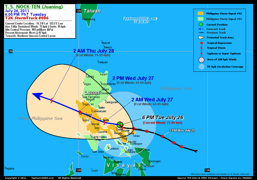
Location of Center: 14.3º N Lat 123.2º E Lon
Distance 1: 35 km (19 nm) NNW of Siruma, CamSur
Distance 2: 40 km (22 nm) NE of Daet, CamNorte
Distance 3: 85 km (45 nm) WNW of Caramoan, CamSur
Distance 4: 70 km (38 nm) NNE of Ragay, CamSur
Distance 5: 80 km (43 nm) North of Metro Naga/CWC
Distance 6: 100 km (55 nm) NNW of Iriga City
Distance 7: 140 km (75 nm) WNW of Virac, Catanduanes
Distance 8: 145 km (78 nm) NNW of Legazpi City
Distance 9: 170 km (92 nm) ESE of Infanta, Quezon
Distance 10: 230 km (125 nm) East of Metro Manila
MaxWinds (1-min avg): 75 kph (40 kts) near the center
Peak Wind Gusts: 95 kph (50 kts)
Present Movement: West @ 07 kph (04 kts)
Towards: Northern Quezon-Central Luzon
CPA [ETA] to Infanta: Wed Morning [4-5AM PhT]
6-12hr Rainfall Accum (near center): 200 mm (High)
Rainrate (near center): 10-20 mm/hr (Mod)
Minimum Central Pressure: 993 millibars (hPa)
Saffir-Simpson Typhoon Scale: Tropical Storm
Size (in Diameter): 555 km (300 nm) / Average
Wind Area Distribution (in Knots): Current Wind Profile
Possible Storm Surge Height: 0 ft [0 m]
T2K TrackMap (for Public): 6:00 PM PhT Tue July 26
FORECAST OUTLOOK ANALYSIS (up to 2 days)* NOCK-TEN's (JUANING) CLOSEST POINT OF APPROACH (CPA)* EXTENDED FORECAST TRACK (3 to 5 days)* EFFECTS & HAZARDS SUMMARY TROPICAL CYCLONE WATCH CURRENT SW MONSOON INTENSITY: STRONG >> Cloudy skies with occasional showers, rains, squalls & thunderstorms will be expected along the following affected areas: PALAWAN & THE REST OF VISAYAS. Light to moderate SW'ly winds (not in excess of 60 kph) will blow. Important Note: Please keep in mind that the above forecast outlook, extended forecast, effects-hazards, current monsoon intensity, & tropical cyclone watch changes every 6 to 12 hrs! PHILIPPINE STORM WARNING SIGNAL # TWO (2) The above areas will experience stormy weather - where winds of 60-100 kph can be expected tonight until tomorrow. Coastal waters will be rough to very rough and extremely dangerous to all types of seacrafts. PHILIPPINE STORM WARNING SIGNAL # ONE (1) The above areas will have rains and winds of not more than 60 kph tonight & tomorrow. Coastal waters will be moderate to rough.
NOCK-TEN (JUANING) is expected to turn WNW-ward into Central Luzon & across the South China Sea within the next 2 days. It shall weaken upon traversing Luzon and re-intensify upon emerging over the West Philippine Sea (South China Sea). Below is the summary of the 2-day forecast for this system.  TOMORROW EARLY MORNING (WED): Over Polillo Islands as prepares to make landfall near Real, Quezon....about 110 km East of Metro Manila [2AM JUL 27: 14.5N 122.0E @ 65kph]. This system is expected to make landfall over or very near Real, Quezon early tomorrow morning (between 4-5 AM)...and cross Northern Quezon-Northern Rizal-Tarlac-Bulacan-Pampanga-and Zambales tomorrow morning until early tomorrow afternoon. It will pass about 35 km NE of Metro Manila approx. 8 AM tomorrow. TOMORROW AFTERNOON (WED): Weakened Downgraded to a Tropical Depression (TD) upon crossing Central Luzon...in the vicinity of Iba, Zambales...about 60 km NNW of Subic Bay/Olongapo City [2PM JUL 27: 15.3N 120.1E @ 55kph]. THURSDAY EARLY MORNING: Regains Tropical Storm strength as it moves away from Western Luzon, across the West Philippine Sea (South China Sea)...about 255 km West of Dagupan City, Pangasinan [2AM JUL 28: 16.2N 117.9E @ 75kph]. THURSDAY AFTERNOON: Gaining more strength while over the South China Sea...about 575 km ESE of Hainan Island, China [2PM JUL 28: 17.2N 115.6E @ 95kph].
Maximum Sustained Winds (1-min. avg) are near 75 km/hr (40 knots) with higher gusts. NOCK-TEN (JUANING) is a Tropical Storm (TD) on the Saffir-Simpson Tropical Cyclone Scale. NOCK-TEN is an average-sized tropical cyclone with a diameter of 555 kilometers (300 nautical miles) across. NORTHERN QUEZON: Making landfall over Real, Quezon...about 15 km SSW of Infanta, Quezon [ETA: between 4:00-5:00 AM PhT Tomorrow]. METRO MANILA: Over Bulacan...about 25 km NNE of Quezon City [ETA: between 7:00-8:00 AM PhT Tomorrow]. CLARK, PAMPANGA: About 10 km SSW of Angeles City [ETA: between 10:00-11:00 AM PhT Tomorrow]. FRIDAY AFTERNOON: Continues to intensify as it approaches the east coast of Hainan Island [2PM JUL 29: 18.8N 112.3E @ 85kph]. SATURDAY AFTERNOON: Downgraded to a TD upon crossing Hainan Island [2PM JUL 30: 19.8N 109.6E @ 55kph]. SUNDAY AFTERNOON: Dissipating into an area of Low Pressure as it approaches Northern Vietnam [2PM JUL 31: 19.8N 106.7E @ 35kph].
**Alternate Forecast Scenario (AFS): There is a possibility that NOCK-TEN will turn WNW to NW-ward and cross Northern Luzon early tomorrow morning...making landfall along Baler, Aurora and crossing Northern Luzon - if the strong High Pressure Steering Ridge north of the storm weakens abruptly.
*Please be reminded that the Forecast Outlook changes every 6 hours, and the Extended Forecast Track have an average error of 250 km on Day 3...450 km on Day 4...and 650 km on Day 5, while the wind speed forecast error, averages 35 kph per day. Therefore, a turn to the left or right of its future track and changes in its wind speed must be anticipated from time to time.
NOCK-TEN's (JUANING) circulation being affected by the land terrain of Bicol Peninsula, but managed to re-organize with a developing Central Dense Overcast (CDO) over the center. Most of its thick convective rainbands are located along the southern portion of the center. Below is the summary of the storm's parts and its hazards affecting specific areas: INNER RAINBANDS - spreading & affecting Bicol Region except Masbate. Tropical Storm Conditions w/ Tropical Storm Force Winds (62-95 kph) will be expected along these bands. OUTER RAINBANDS - spreading & affecting most parts of Luzon including Metro Manila, Northern Samar, Masbate, Mindoro, Marinduque, & Southern Tagalog Provinces. Tropical Depression Conditions w/ moderate to strong winds (25-61 kph) will be expected along these bands (click here to know more about Rainbands). 06-12HR TOTAL RAINFALL ACCUMULATION - from 5 up to 100 mm (low to high rainfall) can be expected along the outer & inner rainbands...with isolated amounts of up to 200 mm (high) near the center of MA-ON (INENG), especially along the southern portion. (click to open NOAA's eTRaP graphic).
Tropical Depression 11W (UNNAMED) has been relocated while moving across the Caroline Islands...may reach Tropical Storm status later today. Its center was located near lat 8.4N lon 142.8E...about 595 km SSW of Guam, CNMI...with 1-min maximum sustained winds of 55 kph near the center. View the latest satellite flash loop on this disturbance. ![]()
PAGASA Philippine Storm Warnings Signals 
In Effect: CAMARINES PROVINCES, ALBAY, CATANDUANES, PANGASINAN, NUEVA ECIJA, ZAMBALES, PAMPANGA, TARLAC, BULACAN, BATAAN, RIZAL, CAVITE, LAGUNA, BATANGAS, QUEZON, POLILLO ISLAND, & METRO MANILA.
In Effect: THE REST OF LUZON, MINDORO PROVINCES, LUBANG ISLAND, MARINDUQUE, ROMBLON, BURIAS ISLAND, MASBATE, TICAO ISLAND, & SORSOGON.
Residents living in low-lying and mountainous areas under Public Storm Warning Signal Number 1 are alerted against flashfloods, mudslides and landslides.
REMARKS (for Meteorologists): 2 PM (06 GMT) TUE 26 JULY POSITION: 14.1N 123.3E.
*TROPICAL STORM (TS) 10W (NOCK-TEN), LOCATED APPROXIMATELY 137 NM
EAST-SOUTHEAST OF MANILA, PHILIPPINES, HAS TRACKED WESTWARD AT
05 KNOTS OVER THE PAST SIX HOURS. ANIMATED MULTISPECTRAL IMAGERY
SHOWS THE SYSTEM HAS MAINTAINED DEPTH AROUND ITS CENTRAL CONVECTION
EVEN AS IT APPROACHES SOUTHERN LUZON. THE INITIAL POSITION IS BASED
ON THE ABOVE ANIMATION AND TRIANGULATED FROM NEARBY OBSERVATIONS
WITH FAIR CONFIDENCE. THE INITIAL INTENSITY IS SUPPORTED BY SAME
OBSERVATIONS AND BY DVORAK ESTIMATES FROM PGTW, KNES, AND RJTD
RANGING FROM 30 TO 40 KNOTS. UPPER LEVEL ANALYSIS INDICATES THE
STORM IS JUST TO THE SOUTHWEST OF A TROUGH THAT IS HAVING A
SUBSIDENT EFFECT OVER THE NORTHEAST FLANK OF THE SYSTEM. HOWEVER, A
RIDGE AXIS TO THE SOUTH IS ENHANCING EQUATORWARD OUTFLOW. THESE
DYNAMICS ARE EVIDENT ON WATER VAPOR SATELLITE ANIMATION. VERTICAL
WIND SHEAR (VWS) VALUES ARE LIGHT TO MODERATE (10-2O KTS). TS 10W IS
TRACKING ALONG THE SOUTHERN PERIPHERY OF A DEEP-LAYERED SUBTROPICAL
RIDGE ANCHORED TO THE EAST OF JAPAN. IT IS EXPECTED TO CONTINUE
ALONG THIS TRACK AS IT MAKES LANDFALL NEAR LEGASPI CITY, THEN DRAGS
OVER ROUGH TERRAIN JUST NORTH OF MANILA, BEFORE EXITING INTO THE
SOUTH CHINA SEA AFTER TAU 24. THE SYSTEM WILL GRADUALLY REINTENSIFY
OVER WARM WATERS AND FAVORABLE VWS BEFORE MAKING A SECONDARY
LANDFALL - THIS TIME OVER HAINAN AFTER TAU 72. TS NOCK-TEN WILL
MOMENTARILY INTENSIFY OVER THE GULF OF TONKIN TOWARDS THE END OF THE
FORECAST PERIOD. THE AVAILABLE NUMERICAL GUIDANCE IS IN TIGHT
AGREEMENT WITH THE SOLE EXCEPTION OF NOGAPS THAT IS ERRONEOUSLY
DEFLECTING THE VORTEX NORTHWESTWARD DURING THE FIRST 36 HOURS. THIS
TRACK FORECAST IS SLOWER AND TO THE SOUTH OF CONSENSUS DURING THAT
TIME FRAME...(more info)
>> NOCK-TEN, meaning: Bird. Name contributed by: Laos.
_______________________________________________________________________________________________________________________________________
RECENT TYPHOON2000.COM (JTWC) TRACKING CHART:
_________________________________________________________________________________________________________________
RECENT MULTI-AGENCY TROPICAL CYCLONE FORECAST TRACKING CHART: 

> Image source: NOAA SATELLITE CENTER: http://www.ssd.noaa.gov/mtsat/flt/t1/rgb.jpg
> Image source: Wunderground.com Tropical Page (http://www.wunderground.com/tropical)
____________________________________________________________________________________________________________________
LATEST 6-12HR. TOTAL RAINFALL AMOUNTS / ENSEMBLE TROPICAL RAINFALL POTENTIAL (eTRaP):

> Image source: NOAA Satellite & Information Service (http://www.ssd.noaa.gov/PS/TROP/etrap.html)
>> To know the meteorological terminologies and acronyms used on this update visit the ff:
http://typhoon2000.ph/tcterm.htm
http://www.nhc.noaa.gov/aboutgloss.shtml
http://www.srh.noaa.gov/oun/severewx/glossary.php
http://www.srh.weather.gov/fwd/glossarynation.html
http://www.nhc.noaa.gov/acronyms.shtml
__________________________________________________________________________________________
For the complete details on TS NOCK-TEN (JUANING)...go visit our website @:
> http://www.typhoon2000.com
> http://www.maybagyo.com
Copyright © 2011 Typhoon2000.com All Rights Reserved

No comments:
Post a Comment