
for Tuesday, 19 October 2010 [4:49 PM PhT]![]()

<<<Typhoon2000.com Mobile >>>
Get the latest 3-hrly SMS Storm Alerts on JUAN!
For more details: Text T2K TYPHOON to
2800 (Globe/TM) | 216 (Smart/TNT) | 2288 (Sun)
*only P2.50 (Smart/Globe) / P2.00 (Sun) per msg received.
powered by: Synermaxx
Typhoon2000 (T2K) NEWS (Tuesday Oct 19 2010):
Currently issuing 3-hrly web & SMS updates on MEGI (JUAN). Meanwhile, T2K have revised the EFFECTS AND HAZARDS section in this advisory - making it clear and concise to the readers.
MEGI (JUAN) MAX WIND SPEED PER AGENCY:
+ USA (JTWC/1-min avg): 165 km/hr
+ Japan (JMA/10-min avg): 160 km/hr
+ Philippines (PAGASA/10-min avg): 175 km/hr
+ Korea (KMA/10-min avg): 160 km/hr
+ Taiwan (CWB/10-min avg): 170 km/hr
+ Beijing (NMC/2-min avg): 185 km/hr
+ Hong Kong (HKO/10-min avg): 165 km/hr
TYPHOON MEGI [JUAN/15W/1013]
T2K PUBLIC ADVISORY NUMBER 020
12:00 PM PhT (04:00 GMT) Tue 19 October 2010
Sources: T2K Extrap Analysis/JTWC Wrng #025/SatFix/Recon
View: Advisory Archives (2004-2010)
One of the "Kings" of all Tropical Cyclones, Typhoon MEGI (JUAN)...tenaciously stalls off the west coast of Pangasinan...typhoon conditions continuing across Cape Bolinao. This typhoon is currently reforming and has now a large irregular, ragged shaped eye.
Residents and visitors along Western Luzon should closely monitor the progress of MEGI (JUAN).
Do not use this for life or death decision. This advisory is intended for additional information purposes only. Kindly refer to your country's official weather agency for local warnings, advisories & bulletins.
CURRENT STORM INFORMATION ANALYSIS & FORECAST OUTLOOK (up to 48 hours)* EXTENDED FORECAST TRACK (3 to 5 days)* EFFECTS & HAZARDS SUMMARY Important Note: Please keep in mind that the above forecast outlook, extended forecast, effects-hazards, current monsoon intensity, & tropical cyclone watch changes every 6 to 12 hrs! PHILIPPINE STORM WARNING SIGNAL # TWO (2) The above areas will experience stormy weather today (with winds not exceeding 100 kph). Coastal waters will be rough to very rough and extremely dangerous to all types of seacrafts. PHILIPPINE STORM WARNING SIGNAL # ONE (1) The above areas will have rains and winds of not more than 60 kph today. Coastal waters will be moderate to rough.
Time/Date: 12:00 PM PhT Tue Oct 19 2010
Location of Eye: 16.4º N Lat 118.8º E Lon
Distance 1: 105 km (58 nm) West of Bolinao, Pangasinan
Distance 2: 160 km (85 nm) WSW of Sn.Fernando, La Union
Distance 3: 165 km (90 nm) WNW of Dagupan City
Distance 4: 190 km (103 nm) West of Baguio City
Distance 5: 175 km (95 nm) NW of Iba, Zambales
Distance 6: 315 km (170 nm) NW of Metro Manila
MaxWinds (1-min avg): 165 kph (90 kts) near the center
Peak Wind Gusts: 205 kph (110 kts)
Present Movement: North @ 03 kph (02 kts)
Towards: South China Sea
24-hr Total Rainfall (near center): 510 mm (Very Heavy)
Minimum Central Pressure: 945 millibars (hPa)
Saffir-Simpson Typhoon Scale: Category 2
Size (in Diameter): 925 km (500 nm) / Very Large
Max Sea Wave Height (near center): 32 ft (9.7 m)
Possible Storm Surge Height: 6-8 ft [1.8-2.6 m]
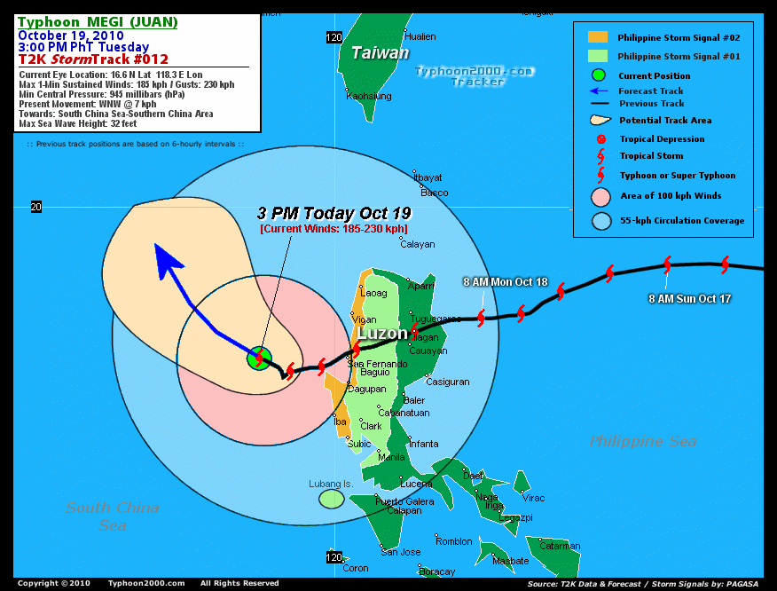
T2K TrackMap #013 (for Public): 3 PM PhT Tue Oct 19
MEGI continues to re-consolidate near the coast of Western Pangasinan...rain-convective clouds continues to wrapped-around tightly into the forming irregular eye, which measures 19 kilometers (10 nm) across. The typhoon is expected to resume moving slowly Westward towards the central portion of the South China Sea within the next 12 hours...turning more WNW to NW-ward in the direction of Southern China. It will eventually regain Category 3 strength later today...and reaching Category 4 anew by Thursday morning [8AM OCT 20: 16.9N 116.4E @ 195kph...8AM OCT 21: 18.5N 115.2E @ 215kph].
Maximum Sustained Winds (1-min. avg) remain near 165 km/hr (90 knots) with higher gusts. MEGI is a Category 2 Typhoon on the Saffir-Simpson Tropical Cyclone Scale. Some strengthening is expected later today as the system moves into warmer sea surface temperatures (SSTs). Typhoon Force Winds (118 km/hr or more) extend outward up to 100 kilometers (55 nautical miles) from the center...and Tropical Storm Force Winds (62-117 km/hr) extend outward up to 260 kilometers (140 nautical miles). MEGI is a very large-sized tropical cyclone with a diameter of 925 kilometers (500 nautical miles).
FRIDAY MORNING: Moving slowly NW-ward...approaching the coast of Southern China...weakens into a Category 3 typhoon [8AM OCT 22: 20.0N 114.0E @ 195kph].
SATURDAY MORNING: Making its last landfall over Western Guangdong, China...about 215 km West of Hong Kong. Downgraded to Category 2 [8AM OCT 23: 21.4N 112.2E @ 165kph].
SUNDAY MORNING Moving inland across Western Guangdong and dissipating...just a strong Tropical Storm [8AM OCT 24: 22.6N 110.3E @ 110kph].
*Please be reminded that the Forecast Outlook changes every 6 hours, and the Extended Forecast Track have an average error of 250 km on Day 3...450 km on Day 4...and 650 km on Day 5, while the wind speed forecast error, averages 35 kph per day. Therefore, a turn to the left or right of its future track and changes in its wind speed must be anticipated from time to time.
MEGI's very large convective circulation continues to cover the whole of Luzon including Palawan...Mindoro...Marinduque...Northern Bicol.
IRREGULAR EYE [19-km Diameter] - still near the coast of Western Pangasinan...some 100 km west of Cape Bolinao.
EASTERN EYEWALL - affecting the coast of Western Pangasinan...where Typhoon Conditions with typhoon force winds (>118 kph) can be expected.
INNER RAINBANDS - continues to affect the provinces of Western Luzon (Ilocos Norte...Ilocos Sur...La Union...Benguet...Pangasinan...Tarlac...Zambales...Pampanga...Bataan)...where Tropical Storm Conditions w/ Tropical Storm Force Winds (65-117 kph) will prevail today.
OUTER RAINBANDS - spreading across the whole of Luzon including Mindoro...Lubang Is...Calamian Group...Palawan...Marinduque...Romblon...Northern Bicol...where moderate to strong winds (<65 kph) will prevail today.
24-HR TOTAL RAINFALL ACCUMULATION - from 5 up to 200 mm (light to heavy rain) can be expected along the outer and inner rainbands...with isolated amounts of up to 510 mm (very heavy) near the center of MEGI...or over the South China Sea [view current NOAA's eTRaP graphic].
COASTAL STORM SURGE FLOODING - possible 6 to 8 feet above normal tide levels...accompanied by large and dangerous battering waves...along the coastal and beach front areas of Western Luzon today. Moderate damage is likely on this type of storm surge. Danger from Rip Currents or Rip Tides can be expected along the rest of the beach-front areas of Eastern & Western Luzon including Bicol Region today.![]()
PAGASA Philippine Storm Warnings Signals

In Effect: ILOCOS PROVINCES, LA UNION, PANGASINAN, ZAMBALES.
In Effect: METRO MANILA, ABRA, APAYAO, KALINGA, MT. PROVINCE, IFUGAO, BENGUET, NUEVA VIZCAYA, NUEVA ECIJA, TARLAC, PAMPANGA, BULACAN, BATAAN, CAVITE, LUBANG ISLAND.
Residents living in low-lying and mountainous areas under Public Storm Warning Signal Numbers 3, 2, & 1 are alerted against flashfloods, mudslides and landslides...while those living in coastal & beach-front areas are advised to seek higher grounds due to possible storm surge (aka. big waves).
External Links for TY MEGI (JUAN)
View NOAA-CIRA's Latest Wind Analysis
JTWC Latest Tracking Chart: wp1510.gif
Multi-Agency Forecast TrackMap: Near Real-Time
TSR Wind Probabilities: Current to 120 hrs Ahead
NASA-JAXA TMI Page: Latest Rainrate 01
EORC-JAXA TRMM Page: Latest Rainrate 02
Zoomed Satellite Pic: NOAA's Near Real-Time
Wunderground Animation: 6-12 hr. GIF Loop
*TYPHOON (TY) 15W (MEGI), LOCATED APPROXIMATELY 455 NM SOUTHEAST
OF HONG KONG, CHINA, HAS TRACKED WESTWARD AT 07 KNOTS OVER THE PAST
SIX HOURS. ANIMATED MULTISPECTRAL SATELLITE IMAGERY INDICATES THAT
TY 15W HAS CONTINUED TO RE-CONSOLIDATE AND HAS DEVELOPED A 10-NM
DIAMETER IRREGULAR EYE OVER THE PAST 06 HOURS. A 182321Z TRMM 37H
IMAGE SHOWS A WELL-DEFINED LOW-LEVEL CIRCULATION CENTER (LLCC) WITH
A MICROWAVE EYE FEATURE AND STRONG CORE CONVECTION OVER ALL
QUADRANTS. ANIMATED WATER VAPOR IMAGERY DEPICTS EXCELLENT RADIAL OUTFLOW
ESPECIALLY POLEWARD OUTFLOW, ENHANCED BY STRONG WESTERLY FLOW ACROSS
CENTRAL CHINA. THERE IS GOOD CONFIDENCE IN THE CURRENT POSITION
BASED ON THE TRMM IMAGE AND EYE. THE CURRENT INTENSITY OF 90 KNOTS
IS BASED ON DVORAK ESTIMATES OF 90 KNOTS FROM PGTW AND KNES...(more)
>> MEGI, meaning: Catfish. Name contributed by: RO Korea.
RECENT TYPHOON2000 TRACKING CHART:
RECENT MULTI-AGENCY TROPICAL CYCLONE FORECAST TRACKING CHART:


> Image source: NOAA SATELLITE & INFORMATION SERVICE
> Image source: Wunderground.com (http://www.wunderground.com/)
____________________________________________________________________________________________________________________
LATEST 24 HR. TOTAL RAINFALL AMOUNTS / ENSEMBLE TROPICAL RAINFALL POTENTIAL (eTRaP):

> Image source: NOAA Satellite & Information Service (http://www.ssd.noaa.gov/PS/TROP/etrap.html)
>> To know the meteorological terminologies and acronyms used on this update visit the ff:
http://typhoon2000.ph/tcterm.htm
http://www.nhc.noaa.gov/aboutgloss.shtml
http://www.srh.noaa.gov/oun/severewx/glossary.php
http://www.srh.weather.gov/fwd/glossarynation.html
http://www.nhc.noaa.gov/acronyms.shtml
__________________________________________________________________________________________
For the complete details on TY MEGI (JUAN)...go visit our website @:
> http://www.typhoon2000.com
> http://www.maybagyo.com
Copyright © 2010 Typhoon2000.com All Rights Reserved

No comments:
Post a Comment