
for Monday, 18 October 2010 [9:39 AM PhT]![]()

<<<Typhoon2000.com Mobile >>>
Get the latest Hourly SMS Storm Alerts on JUAN!
For more details: Text T2K TYPHOON to
2800 (Globe/TM) | 216 (Smart/TNT) | 2288 (Sun)
*only P2.50 (Smart/Globe) / P2.00 (Sun) per msg received.
powered by: Synermaxx
Typhoon2000 (T2K) NEWS (Monday Oct 18 2010):
Currently issuing hrly web, SMS & email advisories on MEGI (JUAN). The T2K HOURLY POSITION ESTIMATE (NOWCASTING) has started. Go to our mainpage.
MEGI (JUAN) MAX WIND SPEED PER AGENCY:
+ USA (JTWC/1-min avg): 285 km/hr
+ Japan (JMA/10-min avg): 220 km/hr
+ Philippines (PAGASA/10-min avg): 225 km/hr
+ Korea (KMA/10-min avg): 220 km/hr
+ Taiwan (CWB/10-min avg): 215 km/hr
+ Beijing (NMC/2-min avg): 260 km/hr
+ Hong Kong (HKO/10-min avg): 220 km/hr
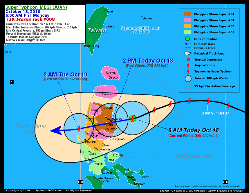
SUPER TYPHOON MEGI [JUAN/15W/1013]
T2K INTERMEDIATE E-MAIL ADVISORY NUMBER 016A
9:00 AM PhT (22:00 GMT) Mon 18 October 2010
Sources: T2K Extrap Analysis/JTWC Wrng #020/SatFix/Recon
View: Advisory Archives (2004-2010)
Super Typhoon MEGI (JUAN) has weakened a little bit...but remains a very dangerous Category 5 system...resumes its Westerly track. Eyewall now moving onshore along the coasts of Cagayan and Isabela.
Residents and visitors along Northern and Central Luzon particularly Cagayan and Isabela should closely monitor the progress of MEGI (JUAN).
Do not use this for life or death decision. This advisory is intended for additional information purposes only. Kindly refer to your country's official weather agency for local warnings, advisories & bulletins.
CURRENT STORM INFORMATION
Time/Date: 9:00 AM PhT Mon Oct 18 2010
Location of Eye: 17.5º N Lat 123.1º E Lon
Distance 1: 140 km (75 nm) ENE of Ilagan, Isabela
Distance 2: 150 km (80 nm) East of Tuguegarao City
Distance 3: 165 km (90 nm) ENE of Cauayan, Isabela
Distance 4: 180 km (98 nm) NE of Casiguran, Aurora
Distance 5: 180 km (98 nm) SE of Aparri, Cagayan
Distance 6: 275 km (148 nm) ESE of Laoag City
Distance 7: 285 km (155 nm) East of Vigan City
Distance 8: 295 km (160 nm) ENE of Baguio City
Distance 9: 385 km (208 nm) NNE of Metro Manila
Distance 10: 435 km (235 nm) North of Metro Naga/CWC
MaxWinds (1-min avg): 270 kph (145 kts) near the center
Peak Wind Gusts: 325 kph (175 kts)
Present Movement: West @ 19 kph (10 kts)
Towards: Isabela-Cagayan Area
24-hr Rain Amounts (near center): 400 mm (Heavy)
Minimum Central Pressure: 885 millibars (hPa)
Saffir-Simpson Typhoon Scale: Category 5
Size (in Diameter): 1,055 km (570 nm) / Very Large
Max Sea Wave Height (near center): 38 ft (11.5 m)
Possible Storm Surge Height: >18 ft [>5.5 m]
T2K TrackMap #008 (for Public): 6 AM PhT Mon Oct 18
______________________________________________________________________________________________________________________________________
RECENT TYPHOON2000 TRACKING CHART:
RECENT MULTI-AGENCY TROPICAL CYCLONE FORECAST TRACKING CHART:


> Image source: NOAA SATELLITE CENTER
> Image source: Wunderground.com (http://www.wunderground.com/)
____________________________________________________________________________________________________________________
LATEST 24 HR. TOTAL RAINFALL AMOUNTS / ENSEMBLE TROPICAL RAINFALL POTENTIAL (eTRaP):

> Image source: NOAA Satellite & Information Service (http://www.ssd.noaa.gov/PS/TROP/etrap.html)
>> To know the meteorological terminologies and acronyms used on this update visit the ff:
http://typhoon2000.ph/tcterm.htm
http://www.nhc.noaa.gov/aboutgloss.shtml
http://www.srh.noaa.gov/oun/severewx/glossary.php
http://www.srh.weather.gov/fwd/glossarynation.html
http://www.nhc.noaa.gov/acronyms.shtml
__________________________________________________________________________________________
For the complete details on STY MEGI (JUAN)...go visit our website @:
> http://www.typhoon2000.com
> http://www.maybagyo.com
Copyright © 2010 Typhoon2000.com All Rights Reserved

No comments:
Post a Comment