
for Saturday, 16 October 2010 [6:07 PM PhT]![]()

<<<Typhoon2000.com Mobile >>>
Get the latest 6-hrly SMS Storm Alerts on JUAN!
For more details: Text T2K TYPHOON to
2800 (Globe/TM) | 216 (Smart/TNT) | 2288 (Sun)
*only P2.50 (Smart/Globe) / P2.00 (Sun) per msg received.
powered by: Synermaxx
Typhoon2000 (T2K) NEWS (Saturday Oct 16 2010):![]()
PAGASA issues its HOURLY UPDATES via Twitter. Click here to go to their page. Meanwhile, T2K is currently issuing 6-hrly web, SMS & email advisories (except 12 AM PhT) on MEGI (JUAN). The T2K 3-hourly advisories will commence once the cyclone is within 500 km away from the Philippine Coastline...and hourly position estimates - if the cyclone is within 200 km.
MEGI (JUAN) MAX WIND SPEED PER AGENCY:
+ USA (JTWC/1-min avg): 185 km/hr
+ Japan (JMA/10-min avg): 140 km/hr
+ Philippines (PAGASA/10-min avg): 140 km/hr
+ Korea (KMA/10-min avg): 150 km/hr
+ Taiwan (CWB/10-min avg): 145 km/hr
+ Beijing (NMC/2-min avg): 145 km/hr
+ Hong Kong (HKO/10-min avg): 140 km/hr
TYPHOON MEGI [JUAN/15W/1013]
T2K E-MAIL ADVISORY NUMBER 011
6:00 PM PhT (10:00 GMT) Sat 16 October 2010
Sources: T2K Extrap Analysis/JTWC Wrng #014/SatFix/Recon
View: Advisory Archives (2004-2010)
MEGI (JUAN) has reached Category 3...becomes a Major Typhoon...still heading towards Northeastern Luzon.
Residents and visitors along Luzon particularly the Northern and Eastern Coastlines should closely monitor the progress of MEGI (JUAN).
Do not use this for life or death decision. This advisory is intended for additional information purposes only. Kindly refer to your country's official weather agency for local warnings, advisories & bulletins.
CURRENT STORM INFORMATION ANALYSIS & FORECAST OUTLOOK (up to 48 hours)* EXTENDED FORECAST TRACK (3 to 5 days)* EFFECTS & HAZARDS Important Note: Please keep in mind that the above forecast outlook, extended forecast, effects-hazards, current monsoon intensity, & tropical cyclone watch changes every 6 to 12 hrs!
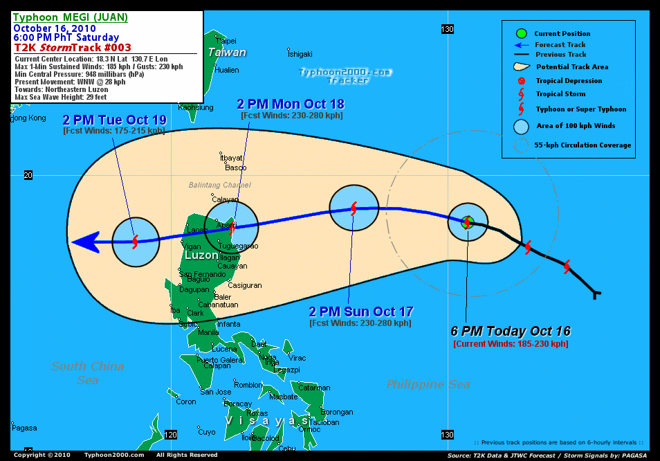
Time/Date: 6:00 PM PhT Sat Oct 16 2010
Location of Center: 18.3º N Lat 130.7º E Lon
Distance 1: 940 km (508 nm) ENE of Casiguran, Aurora
Distance 2: 955 km (515 nm) NE of Metro Naga/CWC
Distance 3: 955 km (515 nm) ENE of Tuguegarao City
Distance 4: 1,115 km (502 nm) NE of Metro Manila
MaxWinds (1-min avg): 185 kph (100 kts) near the center
Peak Wind Gusts: 230 kph (125 kts)
Present Movement: WNW @ 28 kph (15 kts)
Towards: Northeastern Luzon
24-hr Rain Amounts (near center): 250 mm (Heavy)
Minimum Central Pressure: 948 millibars (hPa)
Saffir-Simpson Typhoon Scale: Category 3
Size (in Diameter): 665 km (360 nm) / Avg/Large
Max Sea Wave Height (near center): 29 ft (8.8 m)
Possible Storm Surge Height: 9-12 ft [2.7-3.9 m]
T2K TrackMap #003 (for Public): 6 PM PhT Sat Oct 16
MEGI's eye continues to remain cloud-filled, although recent fly-over observations from a US Air Force C-130 ITOP Reconnaissance measured winds of 185 km/hr, thus the upgrading of MEGI to Category 3. The typhoon is expected to continue moving WNW across the Philippine Sea for the next 12 hours, before shifting its track to the west...west-southwest through 48 hours. MEGI is forecast to reach Cateogory 4 tomorrow [2AM OCT 17: 18.8N 129.0E @ 215kph...2PM OCT 17: 18.8N 126.6E @ 230kph]. By Monday early morning, MEGI will be upgraded to a Super Typhoon (Category 5) w/ 1-minute sustained winds of 250 km/hr...and will slightly weaken as it makes landfall over Cagayan in Northeastern Luzon around 2 PM Monday afternoon [2AM OCT 18: 18.5N 124.2E @ 250kph...2PM OCT 18: 18.1N 122.2E @ 230kph]. Projected Landfall Area (Time): South of Escarpada Point, Northern Cagayan or along the central part of Cagayan Mountains...about 65 km ESE of Aparri on Monday afternoon (around 2 PM). The core of MEGI will cross Extreme Northern Luzon late Monday afternoon through Tuesday early morning...passing about 55 km north of Tuguegarao City (5-6 PM)...and across Apayao...Northern Abra...and Ilocos Provinces. It will also pass between the cities of Laoag and Vigan between 2-3 AM Tuesday - before moving out into the South China Sea.
Maximum Sustained Winds (1-min. avg) have increased to near 185 km/hr (100 knots) with higher gusts. MEGI is now a Category 3 Typhoon on the Saffir-Simpson Tropical Cyclone Scale. The system will continue gaining strength before it makes landfall over Cagayan. Typhoon Force Winds (118 km/hr or more) extend outward up to 85 kilometers (45 nautical miles) from the center...and Tropical Storm Force Winds (62-117 km/hr) extend outward up to 205 kilometers (110 nautical miles). MEGI remains an average-sized tropical cyclone with a diameter of 665 kilometers (360 nautical miles) across.
TUESDAY AFTERNOON: Moving west across the South China Sea, away from NW Luzon...downgraded to Category 2 [2PM OCT 19: 17.6N 118.7E @ 175kph].
WEDNESDAY AFTERNOON: Maintains its westward track across the South China Sea, regains Category 3 strength...heading towards Hainan Island and Northern Vietnam [2PM OCT 20: 17.5N 115.1E @ 185kph].
THURSDAY AFTERNOON: Approaching the southeastern coast of Hainan Island...still intensifying [2PM OCT 21: 17.9N 112.0E @ 195kph].
Alternate Forecast Scenario (AFS): There is a possibility that MEGI will track more west-northwestward towards Batanes and Taiwan -- if the rebuilding of the High Pressure Ridge north of the typhoon will not happen. The probability of this scenerio is low at this time.
*Please be reminded that the Forecast Outlook changes every 6 hours, and the Extended Forecast Track have an average error of 250 km on Day 3...450 km on Day 4...and 650 km on Day 5, while the wind speed forecast error, averages 35 kph per day. Therefore, a turn to the left or right of its future track and changes in its wind speed must be anticipated from time to time.
MEGI's core (eye and eyewall) and its rainbands continues to remain at sea and are not yet affecting any major land areas at this time. Tropical Storm Conditions w/ Tropical Storm Force Winds will be felt across Northeastern Luzon, particularly Cagayan and Isabela beginning late Sunday night or early Monday morning, Oct 18 (click here to view the latest NOAA-CIRA's Wind Analysis). 24-hr total rainfall amounts of 5 up to 150 mm (light to moderate rain) can be expected along its outer and inner bands...with isolated amounts of up to 250 mm (heavy) near the center of MEGI, especially along the northern portion (Click here to view the latest NOAA's eTRaP graphic on the storm's rainfall amount). ![]()
External Links for TY MEGI (JUAN)
View NOAA-CIRA's Latest Wind Analysis
JTWC Latest Tracking Chart: wp1510.gif
Multi-Agency Forecast TrackMap: Near Real-Time
TSR Wind Probabilities: Current to 120 hrs Ahead
NASA-JAXA TMI Page: Latest Rainrate 01
EORC-JAXA TRMM Page: Latest Rainrate 02
Zoomed Satellite Pic: NOAA's Near Real-Time
Wunderground Animation: 6-12 hr. GIF Loop
*TYPHOON 15W (MEGI), LOCATED APPROXIMATELY 640 NM EAST-NORTHEAST OF
MANILA, PHILIPPINES, HAS TRACKED WEST-NORTHWESTWARD AT 15 KNOTS OVER
THE PAST SIX HOURS. RECENT ANIMATED MULTISPECTRAL SATELLITE IMAGERY
SHOWS AN EXPANDING CENTRAL DENSE OVERCAST WITH TIGHTLY CURVED
BANDING OUTLINING AN EMBEDDED CENTER. THE LATEST DVORAK INTENSITY
ESTIMATE FROM PGTW (T5.5) AND A 160350Z ITOP VORTEX MESSAGE SUPPORT
AN INITIAL INTENSITY OF 100 KNOTS. OUTFLOW CONTINUES TO BE
RESTRICTED ON THE WEST SIDE BY AN INVERTED TROUGH OVER THE
PHILIPPINE SEA. HOWEVER, EQUATORWARD OUTFLOW HAS IMPROVED INTO A
TROPICAL UPPER TROPOSPHERIC TROUGH CELL LOCATED NEAR 17N 153E. THE
FORECAST PHILOSPOHY RAMAINS UNCHANGED. CURRENTLY TY 15W IS TRACKING
ALONG THE SOUTHERN PERIPHERY OF THE DEEP LAYER SUBTROPICAL RIDGE
AXIS THAT IS ANCHORED TO AN ANTICYCLONE LOCATED NEAR 30N 160E.
ANALYSIS OF 500 MB GEOPOTENTIAL HEIGHTS ACROSS SOUTHEAST ASIA
INDICATE THAT RIDGING HAS BEGUN TO STRENGTHEN IN THE WAKE OF A
PASSING MID-LATITUDE TROUGH TO THE NORTH. THE 16/00Z NOGAPS AND WBAR
RUNS HAVE WALKED SOUTH NEARER TO THE REST OF THE MODEL PACKING,
WHICH IS CONSISTENT WITH A STRENGTHENING STEERING RIDGE. THE
INTENSITY FORECAST IS HINGED ON THE TROUGH TO THE WEST FILLING AND
IMPROVED POLEWARD OUTFLOW AS AN UPPER LEVEL TROUGH PASSES TO THE
NORTH. REINTENSIFICATION IS STILL ANTICIPATED IN THE SOUTH CHINA
SEA...(more)
>> MEGI, meaning: Catfish. Name contributed by: RO Korea.
RECENT TYPHOON2000 TRACKING CHART:
RECENT MULTI-AGENCY TROPICAL CYCLONE FORECAST TRACKING CHART:


> Image source: NOAA SATELLITE CENTER
> Image source: Wunderground.com (http://www.wunderground.com/)
____________________________________________________________________________________________________________________
LATEST 24 HR. TOTAL RAINFALL AMOUNTS / ENSEMBLE TROPICAL RAINFALL POTENTIAL (eTRaP):

> Image source: NOAA Satellite & Information Service (http://www.ssd.noaa.gov/PS/TROP/etrap.html)
>> To know the meteorological terminologies and acronyms used on this update visit the ff:
http://typhoon2000.ph/tcterm.htm
http://www.nhc.noaa.gov/aboutgloss.shtml
http://www.srh.noaa.gov/oun/severewx/glossary.php
http://www.srh.weather.gov/fwd/glossarynation.html
http://www.nhc.noaa.gov/acronyms.shtml
__________________________________________________________________________________________
For the complete details on TY MEGI (JUAN)...go visit our website @:
> http://www.typhoon2000.com
> http://www.maybagyo.com
Copyright © 2010 Typhoon2000.com All Rights Reserved

No comments:
Post a Comment