
for Saturday, 16 October 2010 [12:11 PM PhT]![]()

<<<Typhoon2000.com Mobile >>>
Get the latest 6-hrly SMS Storm Alerts on JUAN!
For more details: Text T2K TYPHOON to
2800 (Globe/TM) | 216 (Smart/TNT) | 2288 (Sun)
*only P2.50 (Smart/Globe) / P2.00 (Sun) per msg received.
powered by: Synermaxx
Typhoon2000 (T2K) NEWS (Saturday Oct 16 2010):
PAGASA issues its HOURLY UPDATES via Twitter. Click here to go to their page. Meanwhile, T2K currently issuing 6-hrly web, SMS & email advisories (except 12 AM PhT) on MEGI (JUAN).
MEGI (JUAN) MAX WIND SPEED PER AGENCY:
+ USA (JTWC/1-min avg): 165 km/hr
+ Japan (JMA/10-min avg): 140 km/hr
+ Philippines (PAGASA/10-min avg): 140 km/hr
+ Korea (KMA/10-min avg): 150 km/hr
+ Taiwan (CWB/10-min avg): 145 km/hr
+ Beijing (NMC/2-min avg): 145 km/hr
+ Hong Kong (HKO/10-min avg): 130 km/hr
TYPHOON MEGI [JUAN/15W/1013]
T2K E-MAIL ADVISORY NUMBER 010
12:00 PM PhT (04:00 GMT) Sat 16 October 2010
Sources: T2K Extrap Analysis/JTWC Wrng #013/SatFix/Recon
View: Advisory Archives (2004-2010)
Typhoon MEGI (JUAN) picking up speed while moving WNW across the Philippine Sea...threat to Northern Luzon continues.
Residents and visitors along Luzon particularly the Northern and Eastern Coastlines should closely monitor the progress of MEGI (JUAN).
Do not use this for life or death decision. This advisory is intended for additional information purposes only. Kindly refer to your country's official weather agency for local warnings, advisories & bulletins.
CURRENT STORM INFORMATION ANALYSIS & FORECAST OUTLOOK (up to 48 hours)* EXTENDED FORECAST TRACK (3 to 5 days)* EFFECTS & HAZARDS Important Note: Please keep in mind that the above forecast outlook, extended forecast, effects-hazards, current monsoon intensity, & tropical cyclone watch changes every 6 to 12 hrs!
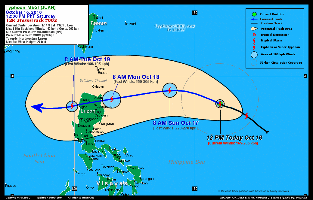
Time/Date: 12:00 PM PhT Sat Oct 16 2010
Location of Center: 17.7º N Lat 132.1º E Lon
Distance 1: 935 km (505 nm) NE of Metro Naga/CWC
Distance 2: 1,075 km (580 nm) ENE of Casiguran, Aurora
Distance 3: 1,100 km (595 nm) East of Tuguegarao City
Distance 4: 1,235 km (667 nm) ENE of Metro Manila
MaxWinds (1-min avg): 165 kph (90 kts) near the center
Peak Wind Gusts: 205 kph (110 kts)
Present Movement: WNW @ 28 kph (15 kts)
Towards: Northeastern Luzon
24-hr Rain Amounts (near center): 300 mm (Heavy)
Minimum Central Pressure: 956 millibars (hPa)
Saffir-Simpson Typhoon Scale: Category 2
Size (in Diameter): 665 km (360 nm) / Avg/Large
Max Sea Wave Height (near center): 27 ft (8.2 m)
Possible Storm Surge Height: 6-8 ft [1.8-2.6 m]
T2K TrackMap #002 (for Public): 12 PM PhT Sat Oct 16
MEGI's eye remains cloud-filled...strong circulation continues on all quadrants except along the southern part. The storm is expected to move WNW across the warm waters of the Philippine Sea for the next 24 hours, before it bends west to west-southwest through 48 hours. It will become a Major Typhoon (Category 3) later today...and strengthen to Category 4 by tomorrow morning [8PM OCT 16: 18.5N 130.3E @ 195kph...8AM OCT 17: 18.8N 127.9E @ 220kph]. By Monday morning, MEGI is forecast to be near the coast of Cagayan and will reach Super Typhoon status w/ 1-minute sustained winds of 250 km/hr (Category 5)...tracking slightly WSW-ward. [8AM OCT 18: 18.1N 123.1E @ 250kph]. Projected Landfall Area (Time): South of Escarpada Point, Northern Cagayan or along the southern part of Cagayan Mountains...about 70 km ENE of Tuguegarao City by Monday afternoon (approx between 2-3 PM). The core will cross Extreme Northern Luzon late Monday afternoon through Tuesday early morning...passing about 35 km north of Tuguegarao City (5-6 PM)...and across Apayao...Abra...and Ilocos Sur. It will also pass over or very close to Vigan City between 4-5 AM Tuesday morning - before moving out into the South China Sea.
Maximum Sustained Winds (1-min. avg) are near 165 km/hr (90 knots) with higher gusts. MEGI is a Category 2 Typhoon on the Saffir-Simpson Tropical Cyclone Scale. The system will continue gaining strength before it makes landfall over Cagayan. Typhoon Force Winds (118 km/hr or more) extend outward up to 55 kilometers (30 nautical miles) from the center...and Tropical Storm Force Winds (62-117 km/hr) extend outward up to 175 kilometers (85 nautical miles). MEGI remains an average-sized tropical cyclone with a diameter of 665 kilometers (360 nautical miles) across.
TUESDAY MORNING: Over the South China Sea or near the coast of Ilocos Sur...moving WSW. Downgraded to Category 2 [8AM OCT 19: 17.5N 119.8E @ 160kph].
WEDNESDAY MORNING: Turns Westward while over the Central part of the South China Sea...away from Luzon, towards Hainan Island-Vietnam Area [8AM OCT 20: 17.2N 116.0E @ 165kph].
THURSDAY MORNING: Moving closer to the southern coast of Hainan Island...approaching Category 3 strength [8AM OCT 21: 17.5N 112.8E @ 175kph].
Alternate Forecast Scenario (AFS): There is a possibility that MEGI will track more west-northwestward towards Batanes and Taiwan -- if the rebuilding of the High Pressure Ridge north of the typhoon will not happen.
*Please be reminded that the Forecast Outlook changes every 6 hours, and the Extended Forecast Track have an average error of 250 km on Day 3...450 km on Day 4...and 650 km on Day 5, while the wind speed forecast error, averages 35 kph per day. Therefore, a turn to the left or right of its future track and changes in its wind speed must be anticipated from time to time.
MEGI's core (eye and eyewall) and its rainbands remain at sea and are not yet affecting any major land areas at this time. Tropical Storm Conditions w/ Tropical Storm Force Winds will be felt across Northeastern Luzon, particularly Cagayan and Isabela beginning Monday early morning, Oct 18 (click here to view the latest NOAA-CIRA's Wind Analysis). 24-hr total rainfall amounts of 5 up to 150 mm (light to moderate rain) can be expected along its outer and inner bands...with isolated amounts of up to 300 mm (heavy) near the center of MEGI, especially along the northern portion (Click here to view the latest NOAA's eTRaP graphic on the storm's rainfall amount). ![]()
External Links for TY MEGI (JUAN)
View NOAA-CIRA's Latest Wind Analysis
JTWC Latest Tracking Chart: wp1510.gif
Multi-Agency Forecast TrackMap: Near Real-Time
TSR Wind Probabilities: Current to 120 hrs Ahead
NASA-JAXA TMI Page: Latest Rainrate 01
EORC-JAXA TRMM Page: Latest Rainrate 02
Zoomed Satellite Pic: NOAA's Near Real-Time
Wunderground Animation: 6-12 hr. GIF Loop
*TYPHOON 15W (MEGI), LOCATED APPROXIMATELY 705 NM EAST-
NORTHEAST OF MANILA, PHILIPPINES, HAS TRACKED WEST-NORTHWESTWARD AT
15 KNOTS OVER THE PAST SIX HOURS. ANIMATED MULTISPECTRAL SATELLITE
IMAGERY AND A 152017Z SSMIS 91H MICROWAVE IMAGE DEPICT A WELL
DEFINED LOW-LEVEL CIRCULATION CENTER WITH TIGHTLY CURVED CONVECTIVE
BANDING (TCB) WRAPPING IN FROM THE SOUTHEASTERN QUADRANT. ANIMATED
WATER VAPOR IMAGERY INDICATES GOOD EQUATORWARD OUTFLOW, WHILE
POLEWARD OUTFLOW HAS YET TO BE ENHANCED BY A PASSING MID-LATITUDE
SHORTWAVE TROUGH NORTH OF THE SYSTEM. TY 15W IS CURRENTLY
EXPERIENCING SOME DEFORMATION ALONG ITS NORTHWESTERN QUADRANT
ASSOCIATED WITH AN UPPER LEVEL LOW, WHICH APPEARS TO BE FILLING
SLOWLY. THERE IS HIGH CONFIDENCE IN THE CURRENT POSITION BASED ON
THE TCB AND A MICROWAVE EYE IN A PARTIAL 160032Z TRMM 37H MICROWAVE
PASS. THE CURRENT INTENSITY IS BASED ON DVORAK ESTIMATES OF 90 KNOTS
FROM RJTD, PGTW, AND KNES...(more)
>> MEGI, meaning: Catfish. Name contributed by: RO Korea.
RECENT TYPHOON2000 TRACKING CHART:
RECENT MULTI-AGENCY TROPICAL CYCLONE FORECAST TRACKING CHART:


> Image source: NOAA SATELLITE CENTER
> Image source: Wunderground.com (http://www.wunderground.com/)
____________________________________________________________________________________________________________________
LATEST 24 HR. TOTAL RAINFALL AMOUNTS / ENSEMBLE TROPICAL RAINFALL POTENTIAL (eTRaP):

> Image source: NOAA Satellite & Information Service (http://www.ssd.noaa.gov/PS/TROP/etrap.html)
>> To know the meteorological terminologies and acronyms used on this update visit the ff:
http://typhoon2000.ph/tcterm.htm
http://www.nhc.noaa.gov/aboutgloss.shtml
http://www.srh.noaa.gov/oun/severewx/glossary.php
http://www.srh.weather.gov/fwd/glossarynation.html
http://www.nhc.noaa.gov/acronyms.shtml
__________________________________________________________________________________________
For the complete details on TY MEGI (JUAN)...go visit our website @:
> http://www.typhoon2000.com
> http://www.maybagyo.com
Copyright © 2010 Typhoon2000.com All Rights Reserved

No comments:
Post a Comment