
for Wednesday, 27 October 2010 [12:45 PM PhT]![]()

<<<Typhoon2000.com Mobile >>>
Get the latest 6-hrly SMS Storm Alerts on KATRING!
For more details: Text T2K TYPHOON to
2800 (Globe/TM) | 216 (Smart/TNT) | 2288 (Sun)
*only P2.50 (Smart/Globe) / P2.00 (Sun) per msg received.
powered by: Synermaxx
Typhoon2000 (T2K) NEWS (Tuesday Oct 26 2010):
Currently issuing 6-hrly SMS, web and e-mail updates (except 12 AM) on TY CHABA (KATRING).
CHABA (KATRING) MAX WIND SPEED PER AGENCY:
+ USA (JTWC/1-min avg): 175 km/hr
+ Japan (JMA/10-min avg): 140 km/hr
+ Philippines (PAGASA/10-min avg): 120 km/hr
+ Korea (KMA/10-min avg): 150 km/hr
+ Taiwan (CWB/10-min avg): 145 km/hr
+ Hong Kong (HKO/10-min avg): 140 km/hr
+ Beijing (NMC/2-min avg): 155 km/hr
:: Click here to see Multi-Agency Forecast Tracks
TYPHOON CHABA [KATRING/16W/1014]
T2K PUBLIC ADVISORY NUMBER 016
12:00 PM PhT (04:00 GMT) Wed 27 October 2010
Sources: T2K Extrap Analysis/JTWC Warning #023/SatFixes
View: Advisory Archives (2004-2010)
Typhoon CHABA (KATRING) has started crawling northward in the direction of Okinawa-Ryukyu Islands...nears Category 3 status.
Residents and visitors along Okinawa and Ryukyu Islands should closely monitor the progress of CHABA.
Do not use this for life or death decision. This advisory is intended for additional information purposes only. Kindly refer to your country's official weather agency for local warnings, advisories & bulletins.
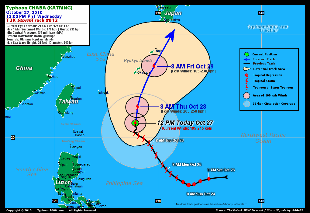
CURRENT STORM INFORMATION
Time/Date: 12:00 PM PhT Wed Oct 27 2010
Location of Eye: 21.4º N Lat 127.8º E Lon
Distance 1: 610 km (330 nm) ENE of Basco, Batanes
Distance 2: 565 km (305 nm) South of Okinawa, Japan
Distance 3: 720 km (390 nm) NE of Aparri, Cagayan
Distance 4: 750 km (405 nm) SE of Taipei, Taiwan
MaxWinds (1-min avg): 175 kph (95 kts) near the center
Peak Wind Gusts: 215 kph (115 kts)
Present Movement: North @ 09 kph (05 kts)
Towards: Okinawa-Ryukyus Area
24-hr Total Rainfall (near center): 220 mm (Heavy)
Minimum Central Pressure: 952 millibars (hPa)
Saffir-Simpson Typhoon Scale: Category 2
Size (in Diameter): 740 km (400 nm) / Large
Max Sea Wave Height (near center): 21 ft (6.4 m)
Possible Storm Surge Height: 6-8 ft [1.8-2.6 m]
T2K TrackMap #12 (for Public): 12 PM PhT Wed Oct 27
FORECAST OUTLOOK ANALYSIS (up to 48 hours)* EXTENDED FORECAST TRACK (3 to 5 days)*
CHABA is expected to continue moving Northward within the next 24 hours before it recurves toward the NE on Friday - in the direction of Okinawa-Ryukyus Area & Southern Japan. By 48 hours, CHABA will begin Extratropical transition, passing close to Okinawa Island on Friday morning between 4-6 AM Japan Time (19-21 GMT) - with a close distance of 140 km to the east of Kadena Air Base [8AM OCT 28: 23.0N 128.0E @ 205kph...8PM OCT 28: 24.8N 128.5E @ 205kph...8AM OCT 29: 26.9N 129.6E @ 185kph].
Maximum Sustained Winds (1-min. avg) have increased to near 175 km/hr (95 knots) with higher gusts. CHABA is a Category 2 Typhoon on the Saffir-Simpson Tropical Cyclone Scale. Continued strengthening is still expected today until tomorrow (Thursday). Typhoon Force Winds (118 km/hr or more) extend outward up to 55 kilometers (30 nautical miles) from the center...and Tropical Storm Force Winds (62-117 km/hr) extend outward up to 240 kilometers (130 nautical miles). CHABA is a large-sized tropical cyclone with a diameter of 740 kilometers (400 nautical miles).  SATURDAY MORNING: Becomes Extratropical as it accelerates rapidly towards the northeast...approaching the coast of Southern Honshu (Japan)...about 140 km SE of Kochi, Japan [8AM OCT 30: 32.5N 134.5E @ 140kph]. SUNDAY MORNING: Just off the east coast of Honshu after traversing South-Central Honshu...about 135 km East of Sendai, Japan [8AM OCT 31: 38.5N 142.4E @ 95kph]. MONDAY MORNING: Passing to the south of Kuril Islands or over the Northwest Pacific...about 515 km SSE of Kuril Islands [8AM NOV 01: 43.0N 154.2E @ 75kph].
*Please be reminded that the Forecast Outlook changes every 6 hours, and the Extended Forecast Track have an average error of 250 km on Day 3...450 km on Day 4...and 650 km on Day 5, while the wind speed forecast error, averages 35 kph per day. Therefore, a turn to the left or right of its future track and changes in its wind speed must be anticipated from time to time.
EFFECTS & HAZARDS SUMMARY
CHABA maintains a strong radial circulation with deep raincloud convection near its center. Below are the summary of the typhoon's parts and its hazards affecting specific areas: CLOUD-FILLED EYE - remains at sea (North Philippine Sea)...not affecting land areas. Possible calm and lull conditions (with <20 kph winds) can be expected inside the eye (click here to know more about the EYE). EYEWALL - remains at sea (North Philippine Sea)...not affecting land areas. Typhoon Conditions with typhoon force winds (>118 kph) can be expected within this wall (click here to know more about the Eyewall). INNER SPIRAL RAINBANDS - remains at sea (Philippine Sea)...not affecting land areas. Tropical Storm Conditions w/ Tropical Storm Force Winds (65-117 kph) can be expected within these bands. OUTER SPIRAL RAINBANDS - spreading across Okinawa and Ryukyu Islands, Where moderate to strong winds (<65 kph) can be expected along these bands today. (click here to know more about Rainbands). 24-HR TOTAL RAINFALL ACCUMULATION - from 5 up to 150 mm (light to moderate rain) can be expected along the outer & inner rainbands...with isolated amounts of up to 220 mm (heavy) near the center of CHABA [click to open NOAA's eTRaP graphic]. COASTAL STORM SURGE FLOODING - possible 4 to 8 feet above normal tide levels...accompanied by large and dangerous battering waves can be expected along the coastal and beach front areas of Batanes, Eastern Taiwan, Okinawa & Ryukyu Islands today. Minimal to moderate damage is likely on this type of storm surge. Danger from Rip Currents or Rip Tides can be expected along the beach-front areas of Northern & Eastern Luzon today. (click here to know more about Storm Surge).
CURRENT NORTHEAST MONSOON INTENSITY: MODERATE >> Partly sunny to mostly cloudy skies with passing showers can be expected along these following affected areas: NORTHERN & EASTERN LUZON, BICOL REGION. Lower temperatures (less than 30 degrees celsius) with cooler light to moderate North and NE winds (not in excess of 35 kph) can be expected today.
CURRENT ITCZ/MONSOON TROUGH INTENSITY: STRONG >> Mostly cloudy skies with isolated to scattered afternoon or evening showers, rains & thunderstorms can be expected along these following affected area: VISAYAS. Light to moderate NW, SE to variable winds (not in excess of 30 kph) can be expected today.
Important Note: Please keep in mind that the above forecast outlook, extended forecast, effects-hazards, current monsoon intensity, & tropical cyclone watch changes every 6 to 12 hrs!![]()
External Links for TY CHABA (KATRING)
View NOAA-CIRA's Latest Wind Analysis
JTWC Latest Tracking Chart: wp1610.gif
Multi-Agency Forecast TrackMap: Near Real-Time
TSR Wind Probabilities: Current to 120 hrs Ahead
NASA-JAXA TMI Page: Latest Rainrate 01
EORC-JAXA TRMM Page: Latest Rainrate 02
Zoomed Satellite Pic: NOAA's Near Real-Time
Wunderground Animation: 6-12 hr. GIF Loop
*TYPHOON (TY) 16W (CHABA), CURRENTLY LOCATED 375 NM SOUTH OF
KADENA AB, OKINAWA, HAS SHOWN ERRATIC (NEARLY QUASI-STATIONARY)
MOVEMENT DURING THE PAST SIX HOURS. ANIMATED MULTISPECTRAL SATELLITE
IMAGERY INDICATES CONVECTION HAS DEEPENED AND CONSOLIDATED OVER THE
SYSTEM DURING THE PAST SIX HOURS IN RESPONSE TO AN ENHANCED POLEWARD
OUTFLOW CHANNEL. RECENT VISUAL SATELLITE IMAGERY SHOWS OVERSHOOTING
CLOUD TOPS NEAR THE TY CORE AND THE BEGINNINGS OF AN EYE. THERE IS
HIGH CONFIDENCE IN THE CURRENT POSITION BASED ON A 26/2228Z SSMIS
91H MICROWAVE IMAGE INDICATING A DEFINITIVE MICROWAVE EYE. THE
CURRENT INTENSITY ANALYSIS IS BASED ON DVORAK CURRENT INTENSITY (CI)
ESTIMATES OF 102 KNOTS FROM PGTW AND 90 KNOTS FROM RJTD. ANIMATED
WATER VAPOR IMAGERY INDICATES WELL-DEVELOPED OUTFLOW CHANNELS EXIST
ON ALL QUADRANTS OF THE STORM. CONTINENTAL POLAR (CP) AIR
ENTRAINMENT FROM A RECENT COLD SURGE APPEARS TO BE MINIMAL THUS FAR,
PRODUCING LITTLE IMPEDIMENT ON STORM DEVELOPMENT. THIS IS LIKELY AN
EFFECT OF PARALLEL NORTHEASTERLY FLOW ALONG THE RYUKUS RATHER THAN
PERPENDICULAR NORTHWESTERLIES. A TOTAL PRECIPITABLE WATER LOOP DOES
SHOW ONE PULSE OF DRIER AIR MADE IT INTO THE SYSTEM CORE BUT WAS
QUICKLY ABSORBED. RECENT SURFACE ANALYSIS SHOWS WINDS ARE BACKING
AND INCREASING OVER THE RYUKUS INDICATING BOUNDARY LEVEL FLOW OF CP
AIR INTO THE STORM WILL SOON INCREASE. VERTICAL WIND SHEAR IS
MINIMAL SOUTH OF 28N, WHERE IT INCREASES RAPIDLY. A WESTERN
EXTENSION OF THE SUB-TROPICAL RIDGE ACTED TO DRIVE THE STORM
WESTWARD BETWEEN 26/06Z AND 26/18Z BUT HAS WEAKENED SIGNIFICANTLY,
CREATING A ALLEY FOR THE STORM TO TURN POLEWARD...(more)
>> CHABA, meaning: Tropical flower (the shoeflower, genus hibiscus). Name contributed by: Thailand.
RECENT TYPHOON2000.COM TRACKING CHART:
RECENT MULTI-AGENCY TROPICAL CYCLONE FORECAST TRACKING CHART:


> Image source: NOAA SATELLITE CENTER
> Image source: Wunderground.com (http://www.wunderground.com/)
____________________________________________________________________________________________________________________
LATEST 24 HR. TOTAL RAINFALL AMOUNTS / ENSEMBLE TROPICAL RAINFALL POTENTIAL (eTRaP):

> Image source: NOAA Satellite & Information Service (http://www.ssd.noaa.gov/PS/TROP/etrap.html)
>> To know the meteorological terminologies and acronyms used on this update visit the ff:
http://typhoon2000.ph/tcterm.htm
http://www.nhc.noaa.gov/aboutgloss.shtml
http://www.srh.noaa.gov/oun/severewx/glossary.php
http://www.srh.weather.gov/fwd/glossarynation.html
http://www.nhc.noaa.gov/acronyms.shtml
__________________________________________________________________________________________
For the complete details on TY CHABA (KATRING)...go visit our website @:
> http://www.typhoon2000.com
> http://www.maybagyo.com
Copyright © 2010 Typhoon2000.com All Rights Reserved

No comments:
Post a Comment