
for Tuesday, 26 October 2010 [7:15 AM PhT]![]()

<<<Typhoon2000.com Mobile >>>
Get the latest 6-hrly SMS Storm Alerts on KATRING!
For more details: Text T2K TYPHOON to
2800 (Globe/TM) | 216 (Smart/TNT) | 2288 (Sun)
*only P2.50 (Smart/Globe) / P2.00 (Sun) per msg received.
powered by: Synermaxx
Typhoon2000 (T2K) NEWS (Tuesday Oct 26 2010):
Currently issuing 6-hrly SMS, web and e-mail updates (except 12 AM) on TY CHABA (KATRING).
CHABA (KATRING) MAX WIND SPEED PER AGENCY:
+ USA (JTWC/1-min avg): 120 km/hr
+ Japan (JMA/10-min avg): 110 km/hr
+ Philippines (PAGASA/10-min avg): 100 km/hr
+ Korea (KMA/10-min avg): 120 km/hr
+ Taiwan (CWB/10-min avg): 105 km/hr
+ Beijing (NMC/2-min avg): 120 kph
:: Click here to see Multi-Agency Forecast Tracks
TYPHOON CHABA [KATRING/16W/1014]
T2K E-MAIL ADVISORY NUMBER 012
6:00 AM PhT (22:00 GMT) Tue 26 October 2010
Sources: T2K Extrap Analysis/JTWC Warning #018/SatFixes
View: Advisory Archives (2004-2010)
CHABA (KATRING) upgraded to Typhoon...still on a NNW heading...now threatens Okinawa-Ryukyu Islands.
Residents and visitors along Okinawa and Ryukyu Islands should closely monitor the progress of CHABA.
Do not use this for life or death decision. This advisory is intended for additional information purposes only. Kindly refer to your country's official weather agency for local warnings, advisories & bulletins.
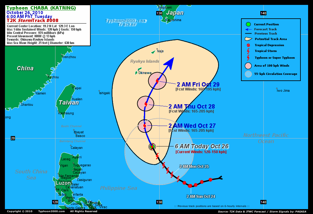
CURRENT STORM INFORMATION
Time/Date: 6:00 AM PhT Tue Oct 26 2010
Location of Developing Eye: 19.2º N Lat 129.3º E Lon
Distance 1: 775 km (418 nm) ESE of Basco, Batanes
Distance 2: 805 km (435 nm) ENE of Aparri, Cagayan
Distance 3: 820 km (443 nm) SSE of Okinawa, Japan
Distance 4: 830 km (448 nm) NE of Casiguran, Aurora
Distance 5: 1010 km (545 nm) NE of Metro Manila
MaxWinds (1-min avg): 120 kph (65 kts) near the center
Peak Wind Gusts: 150 kph (80 kts)
Present Movement: NNW @ 13 kph (07 kts)
Towards: Okinawa-Ryukyus Area
24-hr Total Rainfall (near center): 400 mm (Heavy)
Minimum Central Pressure: 974 millibars (hPa)
Saffir-Simpson Typhoon Scale: Category 1
Size (in Diameter): 630 km (340 nm) / Average
Max Sea Wave Height (near center): 21 ft (6.4 m)
Possible Storm Surge Height: 4-5 ft [1.2-1.7 m]
T2K TrackMap #08 (for Public): 6 AM PhT Tue Oct 26
FORECAST OUTLOOK ANALYSIS (up to 48 hours)* EXTENDED FORECAST TRACK (3 to 5 days)*
CHABA is expected to continue tracking NNW within the next 24 hours before turning sharply to the North in the direction of Okinawa-Ryukyus Area. This system will continue to intensify and will reach its peak strength (Category 2) by tomorrow afternoon...before it starts to weaken. [2AM OCT 27: 21.2N 128.6E @ 165kph...2PM OCT 27: 22.2N 128.5E @ 175kph...2AM OCT 28: 23.3N 128.7E @ 165kph].
Maximum Sustained Winds (1-min. avg) are near 120 km/hr (65 knots) with higher gusts. CHABA is a Category 1 Typhoon on the Saffir-Simpson Tropical Cyclone Scale. Continued strengthening is expected later today until tomorrow. Typhoon Force Winds (118 km/hr or more) extend outward up to 10 kilometers (5 nautical miles) from the center...and Tropical Storm Force Winds (62-117 km/hr) extend outward up to 160 kilometers (85 nautical miles). CHABA is an average-sized tropical cyclone with a diameter of 630 kilometers (340 nautical miles).  FRIDAY EARLY MORNING: Exits the Philippine Area of (Forecasting) Responsibility (PAR)...passing just to the east of Okinawa Island or close to the tiny islands of the Ryukyus...about 210 km SE of Naha, Okinawa [2AM OCT 29: 25.5N 129.8E @ 160kph]. SATURDAY EARLY MORNING: Begins Extratropical transition...accelerating NE-ward, away from Ryukyus...and approaching the southern coastlines of Shikoku and Honshu in Japan...about 455 km SSW of Kochi, Japan [2AM OCT 30: 29.5N 132.4E @ 140kph]. SUNDAY EARLY MORNING: Becomes Extratropical while along the coast of Honshu...about 205 km SW of Tokyo, Japan [2AM OCT 31: 34.1N 138.6E @ 95kph].
*Please be reminded that the Forecast Outlook changes every 6 hours, and the Extended Forecast Track have an average error of 250 km on Day 3...450 km on Day 4...and 650 km on Day 5, while the wind speed forecast error, averages 35 kph per day. Therefore, a turn to the left or right of its future track and changes in its wind speed must be anticipated from time to time.
EFFECTS & HAZARDS SUMMARY
CHABA maintains a radial circulation with deep raincloud convection near its center and southern periphery. Below are the summary of the cyclone's parts and its hazards affecting specific areas: CENTRAL DENSE OVERCAST (CDO) - currently over the North Philippine Sea...with a possible eye and eyewall developing underneath the CDO. Typhoon Conditions with typhoon force winds (>118 kph) can be expected along the forming eyewall. (click here to know more about CDO). DEVELOPING RAINBANDS - continues to improve on all sides, except the Northern and NW portions. Soon, these rainbands will be divided into two parts (the inner and the outer). Moderate to Tropical Storm Force Winds (<117 kph) can be expected along these bands today (click here to know more about Rainbands). 24-HR TOTAL RAINFALL ACCUMULATION - from 5 up to 200 mm (light, moderate to heavy rain) can be expected along the developing rainbands...with isolated amounts of up to 400 mm (heavy) near the center of CHABA [click to open NOAA's eTRaP graphic]. COASTAL STORM SURGE FLOODING - None (click here to know more about Storm Surge).
CURRENT ITCZ/MONSOON TROUGH INTENSITY: MODERATE >> Partly sunny to mostly cloudy skies with isolated to scattered afternoon or evening showers, rains & thunderstorms can be expected along these following affected areas: BICOL REGION, CENTRAL LUZON, METRO MANILA, SOUTHERN LUZON, VISAYAS, & MINDANAO. Light to moderate SW, South, SE winds (not in excess of 30 kph) can be expected today. The prevailing strong La Niña conditions over the Pacific Ocean enhances the ITCZ to be more active across the Philippines.
Important Note: Please keep in mind that the above forecast outlook, extended forecast, effects-hazards, current monsoon intensity, & tropical cyclone watch changes every 6 to 12 hrs!![]()
External Links for TY CHABA (KATRING)
View NOAA-CIRA's Latest Wind Analysis
JTWC Latest Tracking Chart: wp1610.gif
Multi-Agency Forecast TrackMap: Near Real-Time
TSR Wind Probabilities: Current to 120 hrs Ahead
NASA-JAXA TMI Page: Latest Rainrate 01
EORC-JAXA TRMM Page: Latest Rainrate 02
Zoomed Satellite Pic: NOAA's Near Real-Time
Wunderground Animation: 6-12 hr. GIF Loop
*TYPHOON 16W (CHABA), LOCATED APPROXIMATELY 455 NM SOUTH-SOUTHEAST
OF KADENA, JAPAN, HAS TRACKED NORTH-NORTHWEST AT 08 KNOTS DURING THE
PAST SIX HOURS. ANIMATED INFRARED SATELLITE IMAGERY SHOWS CONVECTION
IS CONSOLIDATING OVER THE LOW LEVEL CIRCULATION CENTER AND
INTENSIFYING THEREFORE SYSTEM WAS UPGRADED TO TYPHOON STRENGTH. POLAR
OUTFLOW IS IMPROVING WHILE GOOD EQUATORWARD OUTFLOW PERSISTS. THE
INTENSITY ESTIMATE IS BASED ON DVORAK ESTIMATES OF 65 KNOTS FROM
PGTW, KNES, AND RJTD. TYPHOON CHABA IS EXPECTED TO INTENSIFY AS A
MID-LATITUDE TROUGH CURRENTLY MOVING OVER THE SEA OF JAPAN PROVIDES
FURTHER ENHANCEMENT TO THE POLEWARD OUTFLOW CHANNEL. TYPHOON CHABA IS
EXPECTED TO TRACK SLOWLY POLEWARD ALONG THE SUBTROPICAL STEERING
RIDGE THROUGH TAU 72 AND SHOULD ENTER A ZONE OF RAPIDLY INCREASING
VERTICAL WINDSHEAR NEAR TAU 96. SYSTEM IS EXPECTED TO COMPLETE
EXTRA-TROPICAL TRANSITION BY TAU 120. MODEL GUIDANCE IS IN FAIR
AGREEMENT WITH THE EXCEPTION OF THE WESTWARD-TRACKING (AND ERRONEOUS)
GFDN GUIDANCE...(more)
>> CHABA, meaning: Tropical flower (the shoeflower, genus hibiscus). Name contributed by: Thailand.
RECENT TYPHOON2000.COM TRACKING CHART:
RECENT MULTI-AGENCY TROPICAL CYCLONE FORECAST TRACKING CHART:


> Image source: NOAA SATELLITE CENTER
> Image source: Wunderground.com (http://www.wunderground.com/)
____________________________________________________________________________________________________________________
LATEST 24 HR. TOTAL RAINFALL AMOUNTS / ENSEMBLE TROPICAL RAINFALL POTENTIAL (eTRaP):

> Image source: NOAA Satellite & Information Service (http://www.ssd.noaa.gov/PS/TROP/etrap.html)
>> To know the meteorological terminologies and acronyms used on this update visit the ff:
http://typhoon2000.ph/tcterm.htm
http://www.nhc.noaa.gov/aboutgloss.shtml
http://www.srh.noaa.gov/oun/severewx/glossary.php
http://www.srh.weather.gov/fwd/glossarynation.html
http://www.nhc.noaa.gov/acronyms.shtml
__________________________________________________________________________________________
For the complete details on TY CHABA (KATRING)...go visit our website @:
> http://www.typhoon2000.com
> http://www.maybagyo.com
Copyright © 2010 Typhoon2000.com All Rights Reserved

No comments:
Post a Comment