
for Thursday, 28 October 2010 [8:12 AM PhT]![]()

<<<Typhoon2000.com Mobile >>>
Get the latest 6-hrly SMS Storm Alerts on KATRING!
For Layman's: Text T2K TYPHOON
For Technical: Text T2K TYPHOON TEK
For Signal #s: Text T2K TYPHOON SIGNALS
2800 (Globe/TM) | 216 (Smart/TNT) | 2288 (Sun)
*only P2.50 (Smart/Globe) / P2.00 (Sun) per msg received.
powered by: Synermaxx
Typhoon2000 (T2K) NEWS (Tuesday Oct 26 2010):
Currently issuing 6-hrly SMS, web and e-mail updates (except 12 AM) on TY CHABA (KATRING).
CHABA (KATRING) MAX WIND SPEED PER AGENCY:
+ USA (JTWC/1-min avg): 205 km/hr
+ Japan (JMA/10-min avg): 160 km/hr
+ Philippines (PAGASA/10-min avg): 120 km/hr
+ Korea (KMA/10-min avg): 160 km/hr
+ Taiwan (CWB/10-min avg): 160 km/hr
+ Hong Kong (HKO/10-min avg): 165 km/hr
+ Beijing (NMC/2-min avg): 160 km/hr
:: Click here to see Multi-Agency Forecast Tracks
TYPHOON CHABA [KATRING/16W/1014]
T2K E-MAIL ADVISORY NUMBER 018
6:00 AM PhT (22:00 GMT) Thu 28 October 2010
Sources: T2K Extrap Analysis/JTWC Warning #026/SatFixes
View: Advisory Archives (2004-2010)
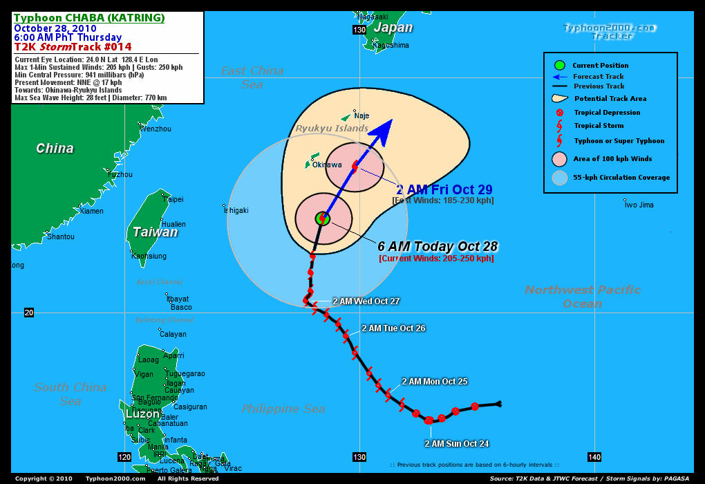
Major Typhoon CHABA (KATRING) now at 205-km/hr...recurving NNE in the direction of Okinawa-Ryukyu Islands...will exit the Philippine Area of Responsibility (PAR) this afternoon.
Residents and visitors along Okinawa and Ryukyu Islands should closely monitor the progress of CHABA.
Do not use this for life or death decision. This advisory is intended for additional information purposes only. Kindly refer to your country's official weather agency for local warnings, advisories & bulletins.
CURRENT STORM INFORMATION
Time/Date: 6:00 AM PhT Thu Oct 28 2010
Location of Eye: 24.0º N Lat 128.4º E Lon
Distance 1: 285 km (155 nm) South of Okinawa, Japan
Distance 2: 535 km (288 nm) SSW of Naje Is., Japan
Distance 3: 700 km (378 nm) ESE of Taipei, Taiwan
Distance 4: 770 km (415 nm) NE of Basco, Batanes
MaxWinds (1-min avg): 205 kph (110 kts) near the center
Peak Wind Gusts: 250 kph (135 kts)
Present Movement: NNE @ 17 kph (09 kts)
Towards: Okinawa-Ryukyus Area
24-hr Total Rainfall (near center): 400 mm (Heavy)
Minimum Central Pressure: 941 millibars (hPa)
Saffir-Simpson Typhoon Scale: Category 3
Size (in Diameter): 775 km (420 nm) / Large
Max Sea Wave Height (near center): 28 ft (8.5 m)
Possible Storm Surge Height: 9-12 ft [2.7-3.9 m]
T2K TrackMap #14 (for Public): 6 AM PhT Thu Oct 28
FORECAST OUTLOOK ANALYSIS (up to 48 hours)* EXTENDED FORECAST TRACK (3 to 4 days)*
CHABA is expected to start recurving more to the NE, passing some 200 km to the east of Kadena Air Base in Okinawa later tonight between 11 PM to 1 AM Japan Time (14-16 GMT). By 36 to 48 hours, CHABA will begin Extratropical transition while passing to the south of Shikoku Island, Japan [2AM OCT 29: 26.2N 129.8E @ 185kph...2PM OCT 29: 28.0N 131.1E @ 165kph...2AM OCT 30: 30.5N 133.1E @ 140kph].
Maximum Sustained Winds (1-min. avg) have increased to near 205 km/hr (110 knots) with higher gusts. CHABA is a Category 3 Typhoon on the Saffir-Simpson Tropical Cyclone Scale. Slow weakening of this system can be expected later tonight as the system enters unfavorable atmospheric conditions. Typhoon Force Winds (118 km/hr or more) extend outward up to 85 kilometers (45 nautical miles) from the center...and Tropical Storm Force Winds (62-117 km/hr) extend outward up to 340 kilometers (185 nautical miles). CHABA is a large-sized tropical cyclone with a diameter of 775 kilometers (420 nautical miles).  SUNDAY EARLY MORNING: Downgraded to Tropical Storm as it becomes extratropical...making landfall over Southern Honshu, Japan - passing very close to Metropolitan Tokyo...about 45 km to the NE [2AM OCT 31: 36.0N 140.0E @ 100kph]. MONDAY EARLY MORNING: Speeding up NE-ward and weakening across the Northwest Pacific Ocean...passing south of the Kuril Islands...about 520 km south to the south [2AM NOV 01: 41.3N 150.8E @ 65kph].
*Please be reminded that the Forecast Outlook changes every 6 hours, and the Extended Forecast Track have an average error of 250 km on Day 3...450 km on Day 4...and 650 km on Day 5, while the wind speed forecast error, averages 35 kph per day. Therefore, a turn to the left or right of its future track and changes in its wind speed must be anticipated from time to time.
EFFECTS & HAZARDS SUMMARY
CHABA maintains a strong radial circulation with a pulsating eye appearance (round to cloud-filled)...its inner rainbands now moving into Okinawa and later across the rest of Ryukyus. Below are the summary of the typhoon's parts and its hazards affecting specific areas: ROUND TO CLOUD-FILLED EYE [33-km in diameter] - remains at sea (North Philippine Sea)...not affecting land areas. Possible calm and lull conditions (with <20 kph winds) can be expected inside the eye (click here to know more about the EYE). EYEWALL - remains at sea (North Philippine Sea)...not affecting land areas. Typhoon Conditions with typhoon force winds (>118 kph) can be expected within this wall (click here to know more about the Eyewall). INNER SPIRAL RAINBANDS - has started moving into Okinawa...and will spread across the rest of Ryukyus later this afternoon or tonight. Tropical Storm Conditions w/ Tropical Storm Force Winds (65-117 kph) can be expected along these bands. OUTER SPIRAL RAINBANDS - affecting Ryukyu Islands, where moderate to strong winds (<65 kph) can be expected along these bands today. (click here to know more about Rainbands). 24-HR TOTAL RAINFALL ACCUMULATION - from 5 up to 200 mm (light, moderate to heavy rain) can be expected along the outer & inner rainbands...with isolated amounts of up to 400 mm (heavy) near the center of CHABA [click to open NOAA's eTRaP graphic]. COASTAL STORM SURGE FLOODING - possible 4 to 12 feet above normal tide levels...accompanied by large and dangerous battering waves can be expected along the coastal and beach front areas of Eastern Taiwan, Okinawa & Ryukyu Islands today. Minimal to extensive damage is likely on this type of storm surge. Danger from Rip Currents or Rip Tides can be expected along the beach-front areas of Southern Japan, Northeastern Luzon and the Batanes Group today. (click here to know more about Storm Surge).
CURRENT NORTHEAST MONSOON INTENSITY: WEAK >> Partly sunny to mostly cloudy skies with passing showers or rains can be expected along these following affected areas: NORTHERN & EASTERN LUZON, BICOL REGION. Lower temperatures (less than 30 degrees celsius) with cooler light to moderate North and NE winds (not in excess of 25 kph) can be expected today.
CURRENT ITCZ/MONSOON TROUGH INTENSITY: MODERATE >> Partly sunny to mostly cloudy skies with scattered to widespread showers, rains & thunderstorms can be expected along these following affected areas: VISAYAS, MASBATE, PALAWAN & MINDANAO. Light to moderate NW, SE to variable winds (not in excess of 25 kph) can be expected today.
Important Note: Please keep in mind that the above forecast outlook, extended forecast, effects-hazards, current monsoon intensity, & tropical cyclone watch changes every 6 to 12 hrs!![]()
External Links for TY CHABA (KATRING)
View NOAA-CIRA's Latest Wind Analysis
JTWC Latest Tracking Chart: wp1610.gif
Multi-Agency Forecast TrackMap: Near Real-Time
TSR Wind Probabilities: Current to 96 hrs Ahead
NASA-JAXA TMI Page: Latest Rainrate 01
EORC-JAXA TRMM Page: Latest Rainrate 02
Zoomed Satellite Pic: NOAA's Near Real-Time
Wunderground Animation: 6-12 hr. GIF Loop
*TYPHOON (TY) 16W (CHABA), LOCATED APPROXIMATELY 180 NM SOUTH
OF KADENA AIR BASE, JAPAN, HAS TRACKED NORTH-NORTHEASTWARD AT 09
KNOTS OVER THE PAST SIX HOURS. ANIMATED INFRARED SATELLITE IMAGERY
SHOWS AN 18 NM EYE. THE CURRENT INTENSITY IS BASED ON PGTW, KNES,
AND RJTD DVORAK ESTIMATES RANGING FROM 102 TO 115 KNOTS. DUAL
OUTFLOW CHANNELS CONTINUE TO SUPPORT INTENSIFICATION OF THE SYSTEM.
POLEWARD OUTFLOW REMAINS VIGOROUS INTO AN UPPER LEVEL LONG WAVE
TROUGH OVER THE NORTH CENTRAL PACIFIC. TY 16W IS CURRENTLY TRACKING
POLEWARD ALONG THE WESTERN EXTENSION OF A DEEP LAYER STEERING RIDGE
TO THE EAST. TY 16W IS FORECAST TO CONTINUE TO TRACK POLEWARD ALONG
THE WESTERN EDGE OF THE STEERING RIDGE TOWARDS A TROUGH-INDUCED
WEAKNESS. THE SYSTEM WILL MAINTAIN ITS CURRENT INTENSITY FOR THE
NEXT 12 HOURS, DUE TO SUSTAINED DUAL OUTFLOW CHANNELS. AROUND TAU 24
THE SYSTEM WILL BEGIN TO WEAKEN DUE TO THE EFFECTS OF INCREASING
VERTICAL WIND SHEAR ASSOCIATED WITH A STRONG POLAR JET SOUTH OF
JAPAN AND DECREASED OCEAN HEAT CONTENT. THE SYSTEM WILL BEGIN TO
ACCELERATE NORTHEASTWARD AS IT CRESTS THE STEERING RIDGE AND BEGINS
EXTRATROPICAL TRANSITION NEAR TAU 36 AS IT INTERACTS WITH A
BAROCLINIC BOUNDARY RUNNING SOUTH OF JAPAN. JUST AFTER TAU 48, TY
16W SHOULD FULLY TRANSITION INTO AN EXTRATROPICAL LOW BEFORE
REACHING MAINLAND JAPAN. NUMERICAL MODEL GUIDANCE IS IN GOOD
AGREEMENT. THEREFORE, THIS FORECAST IS CLOSE TO MODEL
CONSENSUS...(more)
>> CHABA, meaning: Tropical flower (the shoeflower, genus hibiscus). Name contributed by: Thailand.
RECENT TYPHOON2000.COM TRACKING CHART:
RECENT MULTI-AGENCY TROPICAL CYCLONE FORECAST TRACKING CHART:


> Image source: NOAA SATELLITE CENTER
> Image source: Wunderground.com (http://www.wunderground.com/)
____________________________________________________________________________________________________________________
LATEST 24 HR. TOTAL RAINFALL AMOUNTS / ENSEMBLE TROPICAL RAINFALL POTENTIAL (eTRaP):

> Image source: NOAA Satellite & Information Service (http://www.ssd.noaa.gov/PS/TROP/etrap.html)
>> To know the meteorological terminologies and acronyms used on this update visit the ff:
http://typhoon2000.ph/tcterm.htm
http://www.nhc.noaa.gov/aboutgloss.shtml
http://www.srh.noaa.gov/oun/severewx/glossary.php
http://www.srh.weather.gov/fwd/glossarynation.html
http://www.nhc.noaa.gov/acronyms.shtml
__________________________________________________________________________________________
For the complete details on TY CHABA (KATRING)...go visit our website @:
> http://www.typhoon2000.com
> http://www.maybagyo.com
Copyright © 2010 Typhoon2000.com All Rights Reserved

No comments:
Post a Comment