
for Sunday, 17 October 2010 [8:07 PM PhT]![]()

<<<Typhoon2000.com Mobile >>>
Get the latest 3-hrly SMS Storm Alerts on JUAN!
For more details: Text T2K TYPHOON to
2800 (Globe/TM) | 216 (Smart/TNT) | 2288 (Sun)
*only P2.50 (Smart/Globe) / P2.00 (Sun) per msg received.
powered by: Synermaxx
Typhoon2000 (T2K) NEWS (Sunday Oct 17 2010):
Currently issuing 3-hrly web, SMS & email advisories on MEGI (JUAN). The T2K HOURLY POSITION ESTIMATE (NOWCASTING) will begin once the system is less than 200 km away from land. A dry-run of the hourly nowcasting has already begun this afternoon on our mainpage.
MEGI (JUAN) MAX WIND SPEED PER AGENCY:
+ USA (JTWC/1-min avg): 270 km/hr
+ Japan (JMA/10-min avg): 215 km/hr
+ Philippines (PAGASA/10-min avg): 225 km/hr
+ Korea (KMA/10-min avg): 205 km/hr
+ Taiwan (CWB/10-min avg): 215 km/hr
+ Beijing (NMC/2-min avg): 230 km/hr
+ Hong Kong (HKO/10-min avg): 200 km/hr
SUPER TYPHOON MEGI [JUAN/15W/1013]
T2K EMAIL ADVISORY NUMBER 014
6:00 PM PhT (10:00 GMT) Sun 17 October 2010
Sources: T2K Extrap Analysis/JTWC Wrng #018/SatFix/Recon
View: Advisory Archives (2004-2010)
The Extremely Catastrophic Super Typhoon MEGI (JUAN) continues to barrel westward closer to Northern Luzon...particularly Cagayan and Isabela...where Storm Warning Signal #4 are now being raised (see below for full list).
Residents and visitors along Northern and Central Luzon particularly Cagayan and Isabela should closely monitor the progress of MEGI (JUAN).
Do not use this for life or death decision. This advisory is intended for additional information purposes only. Kindly refer to your country's official weather agency for local warnings, advisories & bulletins.
CURRENT STORM INFORMATION ANALYSIS & FORECAST OUTLOOK (up to 48 hours)* EXTENDED FORECAST TRACK (3 to 5 days)* EFFECTS & HAZARDS Important Note: Please keep in mind that the above forecast outlook, extended forecast, effects-hazards, current monsoon intensity, & tropical cyclone watch changes every 6 to 12 hrs! PHILIPPINE STORM WARNING SIGNAL # FOUR (4) PHILIPPINE STORM SIGNAL # THREE (3) PHILIPPINE STORM WARNING SIGNAL # TWO (2) The above areas will experience stormy weather beginning tonight and tomorrow (with winds not exceeding 100 kph...and more than 100 kph for #03...and in excess of 185 kph for #04). Coastal waters will be rough to very rough and extremely dangerous to all types of seacrafts. PHILIPPINE STORM WARNING SIGNAL # ONE (1) The above areas will have rains and winds of not more than 60 kph beginning tonight until tomorrow. Coastal waters will be moderate to rough.
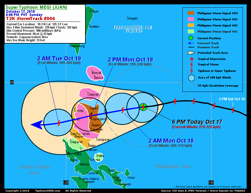
Time/Date: 6:00 PM PhT Sun Oct 17 2010
Location of Eye: 18.3º N Lat 125.3º E Lon
Distance 1: 380 km (205 nm) East of Aparri, Cagayan
Distance 2: 390 km (210 nm) ENE of Tuguegarao City
Distance 3: 390 km (210 nm) ENE of Ilagan, Isabela
Distance 4: 410 km (220 nm) ENE of Cauayan, Isabela
Distance 5: 410 km (220 nm) NE of Casiguran, Aurora
Distance 6: 495 km (267 nm) East of Laoag City
Distance 7: 525 km (283 nm) ENE of Vigan City
Distance 8: 540 km (290 nm) NE of Baguio City
Distance 9: 610 km (330 nm) NE of Metro Manila
MaxWinds (1-min avg): 270 kph (145 kts) near the center
Peak Wind Gusts: 325 kph (175 kts)
Present Movement: West @ 22 kph (12 kts)
Towards: Cagayan-Isabela Area
24-hr Rain Amounts (near center): 470 mm (Heavy)
Minimum Central Pressure: 908 millibars (hPa)
Saffir-Simpson Typhoon Scale: Category 5
Size (in Diameter): 905 km (490 nm) / Very Large
Max Sea Wave Height (near center): 33 ft (10.0 m)
Possible Storm Surge Height: >18 ft [>5.5 m]
T2K TrackMap #006 (for Public): 6 PM PhT Sun Oct 17
MEGI continues to show a small round eye (approximately 37 km across), with very strong eyewall convection. The super typhoon is expected to begin moving on a more WSW track through 36 hours in response to the building High Pressure Ridge located to its NW. MEGI will be just along the coast of Cagayan tomorrow morning...weakening slightly as land interaction begins to affect its circulation [2AM OCT 18: 18.1N 123.9E @ 260kph]. The powerful core of MEGI (eye and eyewall) will begin to move inland around 11 AM or Noontime tomorrow...making landfall over Eastern Cagayan and will start traversing the provinces of Cagayan...Apayao...Kalinga...Abra...and Ilocos Sur - beginning Monday afternoon until early Tuesday morning. The typhoon will be downgraded to Category 3 then later to Category 2 while crossing the mountain ranges of Northern Luzon [2PM OCT 18: 17.7N 121.7E @ 195kph...2AM OCT 19: 17.2N 119.5E @ 165kph]. Projected Landfall Area (Time): South of Escarpada Point, Northern Cagayan or along the Cagayan Mountains...about 50 km ENE of Tuguegarao City Monday noontime. MEGI will pass very close to Tuguegarao City tomorrow afternoon between 1-2 PM...and will be about 15 km South of Vigan City, Ilocos Sur tomorrow evening between 8-9 PM. It will exit Luzon and resume its Westward movement across the South China Sea on Tuesday [2PM OCT 19: 17.1N 117.7E @ 185kph].
Maximum Sustained Winds (1-min. avg) are now near 270 km/hr (145 knots) with higher gusts. MEGI is a Category 5 Typhoon on the Saffir-Simpson Tropical Cyclone Scale...some slight weakening is likely prior to making landfall in Cagayan tomorrow. Typhoon Force Winds (118 km/hr or more) extend outward up to 100 kilometers (55 nautical miles) from the center...and Tropical Storm Force Winds (62-117 km/hr) extend outward up to 240 kilometers (130 nautical miles). MEGI is now a very large-sized tropical cyclone with a diameter of 905 kilometers (490 nautical miles) across.
WEDNESDAY AFTERNOON: Exits the Philippine Area of Responsibility (PAR) while moving slowly across the South China Sea...starts to turn WNW [2PM OCT 20: 17.3N 115.8E @ 195kph].
THURSDAY AFTERNOON: Heading WNW slowly towards Southern China-Hainan Island [2PM OCT 21: 18.0N 114.2E @ 205kph].
FRIDAY AFTERNOON: Regains Category 4 strength as it approaches the coastal areas of Hainan & Western Guangdong (just south of Hong Kong) [2PM OCT 22: 19.0N 112.8E @ 215kph].
*Please be reminded that the Forecast Outlook changes every 6 hours, and the Extended Forecast Track have an average error of 250 km on Day 3...450 km on Day 4...and 650 km on Day 5, while the wind speed forecast error, averages 35 kph per day. Therefore, a turn to the left or right of its future track and changes in its wind speed must be anticipated from time to time.
MEGI's core (eye and eyewall) and its rainbands continues to remain over the warm Philippine Sea...and is moving closer to Northern Luzon. Its outer rainbands has started to spread across Northern Luzon...where moderate to strong winds from 15 to 35 km/hr can be felt this evening and will start deteriorating early tomorrow morning. Tropical Storm Conditions w/ Tropical Storm Force Winds will arrive over Northeastern Luzon, particularly Cagayan and Isabela just after midnight, Oct 18...turning into Typhoon Conditions before noontime tomorrow (Monday) (click here to view the latest NOAA-CIRA's Wind Analysis). 24-hr total rainfall amounts of 5 up to 150 mm (light to moderate rain) can be expected along its outer and inner bands or across Northern Luzon tomorrow...with isolated amounts of up to 470 mm (heavy) near the center of MEGI...or over Cagayan by tomorrow noon (Click here to view the latest NOAA's eTRaP graphic on the storm's rainfall amount). Possible coastal Storm Surge flooding of more than 18 feet above normal tide levels...accompanied by large and dangerous battering waves...is possible along the coastal and beach front areas of Northern Luzon particularly along Cagayan and Isabela beginning tonight until tomorrow. Catastrophic damage is likely on this type of storm surge. Danger from Rip Currents or Rip Tides can be expected along the rest of the beach-front areas of Eastern & Western Luzon including Bicol Region tomorrow.![]()
PAGASA Philippine Storm Warnings Signals

Now In Effect: CAGAYAN & ISABELA.
Now In Effect: BATANES, CALAYAN, BABUYAN, APAYAO, KALINGA, MT. PROVINCE, IFUGAO, QUIRINO, & NORTHERN AURORA.
Now In Effect: ILOCOS PROVINCES, ABRA, LA UNION, BENGUET, NUEVA VIZCAYA, & REST OF AURORA.
In Effect: PANGASINAN, TARLAC, NUEVA ECIJA, & POLILLO ISLAND.
Residents living in low-lying and mountainous areas under Public Storm Warning Signal Numbers 4, 3, 2, & 1 are alerted against flashfloods, mudslides and landslides...while those living in coastal & beach-front areas are advised to seek higher grounds due to possible storm surge (aka. big waves).
External Links for TY MEGI (JUAN)
View NOAA-CIRA's Latest Wind Analysis
JTWC Latest Tracking Chart: wp1510.gif
Multi-Agency Forecast TrackMap: Near Real-Time
TSR Wind Probabilities: Current to 120 hrs Ahead
NASA-JAXA TMI Page: Latest Rainrate 01
EORC-JAXA TRMM Page: Latest Rainrate 02
Zoomed Satellite Pic: NOAA's Near Real-Time
Wunderground Animation: 6-12 hr. GIF Loop
*SUPER TYPHOON (STY) 15W (MEGI) LOCATED APPROXIMATELY 380 NM
NORTHEAST OF MANILA, PHILIPPINES, HAS TRACKED WESTWARD AT 12 KNOTS
OVER THE PAST 06 HOURS. MEGI RETAINS ITS SUPER TYPHOON
CLASSIFICATION AS IT TRACKS ACROSS THE WARM WATERS OF THE PHILIPPINE
SEA TOWARDS NORTHERN LUZON. MAXIMUM SUSTAINED SURFACE WINDS ARE NOW
ESTIMATED TO BE NEAR 145 KNOTS IN ACCORDANCE WITH A 17/0120Z ITOP
VORTEX MESSAGE, WHICH INDICATES MAXIMUM SURFACE WINDS OF 143 KNOTS.
MORE RECENT DVORAK ESTIMATES FROM PGTW, KNES, AND RJTD ALSO SUPPORT
AT LEAST 140 KNOTS. THE CYCLONE BOASTS AN IMPRESSIVE CONVECTIVE
SIGNATURE AND A CIRCULAR 20 NM DIAMETER EYE WITH A CLOSED EYEWALL.
THE SYSTEM CONTINUES TO VENT TO THE NORTHEAST AHEAD OF AN UPPER
LEVEL LONGWAVE TROUGH AND INTO A TROPICAL UPPER TROPOSPHERIC TROUGH
CELL TO THE EAST. MAGI IS EXPECTED TO MAKE LANDFALL OVER LUZON IN
LESS THAN 24 HOURS AND WEAKEN AS IT TRANSITS ACROSS THE RUGGED
INTERIOR OF LUZON. THE CYCLONE WILL THEN EMERGE INTO THE SOUTH CHINA
SEA AND REINTENSIFY WHILE TRACKING TOWARDS A WEAKENESS IN THE DEEP
LAYER SUBTROPICAL STEERING RIDGE OVER SOUTHERN CHINA. MODEL SPREAD
INCREASES BEYOND 36 HOURS. NONETHELESS, THE OFFICIAL FORECAST
REMAINS CLOSE TO THE MODEL CONSENSUS AND THE ECMWF
SOLUTION..(more)
>> MEGI, meaning: Catfish. Name contributed by: RO Korea.
RECENT TYPHOON2000 TRACKING CHART:
RECENT MULTI-AGENCY TROPICAL CYCLONE FORECAST TRACKING CHART:


> Image source: NOAA SATELLITE CENTER
> Image source: Wunderground.com (http://www.wunderground.com/)
____________________________________________________________________________________________________________________
LATEST 24 HR. TOTAL RAINFALL AMOUNTS / ENSEMBLE TROPICAL RAINFALL POTENTIAL (eTRaP):

> Image source: NOAA Satellite & Information Service (http://www.ssd.noaa.gov/PS/TROP/etrap.html)
>> To know the meteorological terminologies and acronyms used on this update visit the ff:
http://typhoon2000.ph/tcterm.htm
http://www.nhc.noaa.gov/aboutgloss.shtml
http://www.srh.noaa.gov/oun/severewx/glossary.php
http://www.srh.weather.gov/fwd/glossarynation.html
http://www.nhc.noaa.gov/acronyms.shtml
__________________________________________________________________________________________
For the complete details on STY MEGI (JUAN)...go visit our website @:
> http://www.typhoon2000.com
> http://www.maybagyo.com
Copyright © 2010 Typhoon2000.com All Rights Reserved

No comments:
Post a Comment