
for Saturday, 16 October 2010 [8:58 AM PhT]![]()

<<<Typhoon2000.com Mobile >>>
Get the latest 3-hrly SMS Storm Alerts on JUAN!
For more details: Text T2K TYPHOON to
2800 (Globe/TM) | 216 (Smart/TNT) | 2288 (Sun)
*only P2.50 (Smart/Globe) / P2.00 (Sun) per msg received.
powered by: Synermaxx
Typhoon2000 (T2K) NEWS (Sunday Oct 16 2010):
Now issuing 3-hrly web, SMS & email advisories on MEGI (JUAN). The HOURLY POSITION ESTIMATE will start once the system is less than 200 km away from land.
MEGI (JUAN) MAX WIND SPEED PER AGENCY:
+ USA (JTWC/1-min avg): 230 km/hr
+ Japan (JMA/10-min avg): 165 km/hr
+ Philippines (PAGASA/10-min avg): 160 km/hr
+ Korea (KMA/10-min avg): 165 km/hr
+ Taiwan (CWB/10-min avg): 170 km/hr
+ Beijing (NMC/2-min avg): 170 km/hr
+ Hong Kong (HKO/10-min avg): 160 km/hr
SUPER TYPHOON MEGI [JUAN/15W/1013]
T2K INTERMEDIATE E-MAIL ADVISORY NUMBER 012A
9:00 AM PhT (01:00 GMT) Sun 17 October 2010
Sources: T2K Extrap Analysis/JTWC Wrng #016/SatFix/Recon
View: Advisory Archives (2004-2010)
MEGI (JUAN) becomes the first Super Typhoon of 2010...still moving westward towards Northeastern Luzon...endangers Cagayan and Isabela Area.
Residents and visitors along Northern and Central Luzon particularly Cagayan and Isabela should closely monitor the progress of MEGI (JUAN).
Do not use this for life or death decision. This advisory is intended for additional information purposes only. Kindly refer to your country's official weather agency for local warnings, advisories & bulletins.
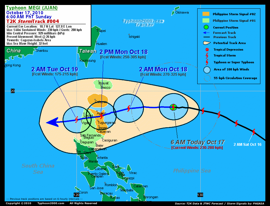
CURRENT STORM INFORMATION
Time/Date: 9:00 AM PhT Sun Oct 17 2010
Location of Eye: 18.7º N Lat 127.2º E Lon
Distance 1: 580 km (313 nm) ENE of Aparri, Cagayan
Distance 2: 580 km (313 nm) ESE of Basco, Batanes
Distance 3: 595 km (322 nm) ENE of Tuguegarao City
Distance 4: 595 km (320 nm) ENE of Ilagan, Isabela
Distance 5: 610 km (328 nm) NE of Casiguran, Aurora
Distance 6: 700 km (378 nm) ENE of Laoag City
Distance 7: 795 km (430 nm) NE of Metro Manila
MaxWinds (1-min avg): 240 kph (130 kts) near the center
Peak Wind Gusts: 295 kph (160 kts)
Present Movement: West @ 26 kph (14 kts)
Towards: Cagayan-Isabela Area
24-hr Rain Amounts (near center): 280 mm (Heavy)
Minimum Central Pressure: 929 millibars (hPa)
Saffir-Simpson Typhoon Scale: Category 4
Size (in Diameter): 740 km (400 nm) / Large
Max Sea Wave Height (near center): 32 ft (9.7 m)
Possible Storm Surge Height: 13-18 ft [4.0-5.5 m]
T2K TrackMap #004 (for Public): 6 AM PhT Sun Oct 17 _______________________________________________________________________________________________________________________________________
RECENT TYPHOON2000 TRACKING CHART:
RECENT MULTI-AGENCY TROPICAL CYCLONE FORECAST TRACKING CHART:


> Image source: NOAA SATELLITE CENTER
> Image source: Wunderground.com (http://www.wunderground.com/)
____________________________________________________________________________________________________________________
LATEST 24 HR. TOTAL RAINFALL AMOUNTS / ENSEMBLE TROPICAL RAINFALL POTENTIAL (eTRaP):

> Image source: NOAA Satellite & Information Service (http://www.ssd.noaa.gov/PS/TROP/etrap.html)
>> To know the meteorological terminologies and acronyms used on this update visit the ff:
http://typhoon2000.ph/tcterm.htm
http://www.nhc.noaa.gov/aboutgloss.shtml
http://www.srh.noaa.gov/oun/severewx/glossary.php
http://www.srh.weather.gov/fwd/glossarynation.html
http://www.nhc.noaa.gov/acronyms.shtml
__________________________________________________________________________________________
For the complete details on STY MEGI (JUAN)...go visit our website @:
> http://www.typhoon2000.com
> http://www.maybagyo.com
Copyright © 2010 Typhoon2000.com All Rights Reserved

No comments:
Post a Comment