
for Monday, 18 October 2010 [1:32 PM PhT]![]()

<<<Typhoon2000.com Mobile >>>
Get the latest Hourly SMS Storm Alerts on JUAN!
For more details: Text T2K TYPHOON to
2800 (Globe/TM) | 216 (Smart/TNT) | 2288 (Sun)
*only P2.50 (Smart/Globe) / P2.00 (Sun) per msg received.
powered by: Synermaxx
Typhoon2000 (T2K) NEWS (Monday Oct 18 2010):
Currently issuing hourly web & SMS updates on MEGI (JUAN). The T2K HOURLY POSITION ESTIMATE (NOWCASTING) has started. Go to our mainpage.
MEGI (JUAN) MAX WIND SPEED PER AGENCY:
+ USA (JTWC/1-min avg): 270 km/hr
+ Japan (JMA/10-min avg): 230 km/hr
+ Philippines (PAGASA/10-min avg): 225 km/hr
+ Korea (KMA/10-min avg): 220 km/hr
+ Taiwan (CWB/10-min avg): 230 km/hr
+ Beijing (NMC/2-min avg): 250 km/hr
+ Hong Kong (HKO/10-min avg): 220 km/hr
SUPER TYPHOON MEGI [JUAN/15W/1013]
T2K E-MAIL ADVISORY NUMBER 017
1:00 PM PhT (04:00 GMT) Mon 18 October 2010
Sources: T2K Extrap Analysis/JTWC Wrng #021/SatFix/Recon
View: Advisory Archives (2004-2010)
The Eye of Super Typhoon MEGI (JUAN) has made landfall over Divilican Bay in Northern Isabela between 11:30 AM to 12:00 PM Manila Time (03:30-04:00 GMT)...and is now passing very close to Ilagan City. Western Eyewall blasting Northern Isabela and Southern Cagayan.
Residents and visitors along Northern and Central Luzon particularly Cagayan, Isabela, Kalinga, Mountain Province, Ifugao and Ilocos Sur should closely monitor the progress of MEGI (JUAN).
Do not use this for life or death decision. This advisory is intended for additional information purposes only. Kindly refer to your country's official weather agency for local warnings, advisories & bulletins.
CURRENT STORM INFORMATION ANALYSIS & FORECAST OUTLOOK (up to 48 hours)* EXTENDED FORECAST TRACK (3 to 5 days)* EFFECTS & HAZARDS Important Note: Please keep in mind that the above forecast outlook, extended forecast, effects-hazards, current monsoon intensity, & tropical cyclone watch changes every 6 to 12 hrs! PHILIPPINE STORM WARNING SIGNAL # FOUR (4) PHILIPPINE STORM SIGNAL # THREE (3) PHILIPPINE STORM WARNING SIGNAL # TWO (2) The above areas will experience stormy weather today (with winds not exceeding 100 kph...and more than 100 kph for #03...and in excess of 185 kph for #04). Coastal waters will be rough to very rough and extremely dangerous to all types of seacrafts. PHILIPPINE STORM WARNING SIGNAL # ONE (1) The above areas will have rains and winds of not more than 60 kph beginning today. Coastal waters will be moderate to rough.
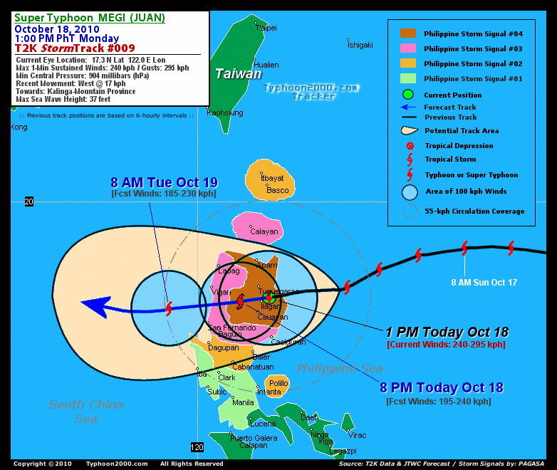
Time/Date: 1:00 PM PhT Mon Oct 18 2010
Location of Eye: 17.3º N Lat 121.9º E Lon
Distance 1: 15 km (8 nm) NE of Ilagan, Isabela
Distance 2: 40 km (22 nm) SE of Tuguegarao City
Distance 3: 50 km (28 nm) NNE of Cauayan, Isabela
Distance 4: 80 km (43 nm) ENE of Banaue Rice Terraces
Distance 5: 140 km (75 nm) ESE of Bangued, Abra
Distance 6: 165 km (90 nm) ESE of Vigan City
Distance 7: 170 km (92 nm) SE of Laoag City
Distance 8: 170 km (92 nm) NE of Baguio City
Distance 9: 310 km (168 nm) NNE of Metro Manila
Distance 10: 435 km (235 nm) NNW of Metro Naga/CWC
MaxWinds (1-min avg): 250 kph (135 kts) near the center
Peak Wind Gusts: 305 kph (165 kts)
Present Movement: West @ 22 kph (12 kts)
Towards: Kalinga-Mountain Province Area
24-hr Rain Amounts (near center): 450 mm (Heavy)
Minimum Central Pressure: 904 millibars (hPa)
Saffir-Simpson Typhoon Scale: Category 5
Size (in Diameter): 1,055 km (570 nm) / Very Large
Max Sea Wave Height (near center): 37 ft (11.2 m)
Possible Storm Surge Height: >18 ft [>5.5 m]
T2K TrackMap #009 (for Public): 1 PM PhT Mon Oct 18
MEGI's intense eye is now feeling the effects of the land as it becomes obscurred...continued weakening of this system can be expected while crossing Northern Luzon. The typhoon will pass just north of Banaue Rice Terraces in Ifugao later today...and will emerge out into the South China Sea, after passing to the south of Vigan, Ilocos Sur late tonight [8PM OCT 18: 17.2N 121.2E @ 195kph...8AM OCT 19: 17.0N 119.2E @ 185kph].. MEGI will be downgraded to a Category 3 typhoon after crossing the mountains of Northern Luzon...and will start to reintensify while over the South China Sea Tuesday evening. By Wednesday morning, the typhoon will exit the Philippine Area of Responsibility (PAR) on its way to Southern China [8PM OCT 19: 17.0N 117.9E @ 195kph...8AM OCT 20: 17.3N 116.7E @ 205kph].
Maximum Sustained Winds (1-min. avg) are near 250 km/hr (135 knots) with higher gusts. MEGI is a Category 5 Typhoon on the Saffir-Simpson Tropical Cyclone Scale. Typhoon Force Winds (118 km/hr or more) extend outward up to 110 kilometers (60 nautical miles) from the center...and Tropical Storm Force Winds (62-117 km/hr) extend outward up to 280 kilometers (150 nautical miles). MEGI is a very large-sized tropical cyclone with a diameter of 1,055 kilometers (570 nautical miles) across.
THURSDAY MORNING: Turning WNW slowly across the South China Sea...regains Category 4 strength...threatens Southern China [8AM OCT 21: 18.0N 115.0E @ 215kph].
FRIDAY MORNING: Downgraded to Category 3 while moving slowly towards Southern China-Hainan Area [8AM OCT 22: 19.0N 113.7E @ 205kph].
SATURDAY MORNING Continues to lose strength...turns more NW'ly as it approaches the coast of Western Guangdong (just SW of Hong Kong) [8AM OCT 23: 20.7N 112.4E @ 185kph].
*Please be reminded that the Forecast Outlook changes every 6 hours, and the Extended Forecast Track have an average error of 250 km on Day 3...450 km on Day 4...and 650 km on Day 5, while the wind speed forecast error, averages 35 kph per day. Therefore, a turn to the left or right of its future track and changes in its wind speed must be anticipated from time to time.
MEGI's large circulation is currently over Northern Luzon. Its inner rainbands spreading across Northern Luzon...while the outer rainbands remain across Central Luzon and portions of Southern Tagalog Provinces iincluding Metro Manila...Moderate to strong winds of up to 55 km/hr can be expected along the outer rainbands of MEGI. Tropical Storm Conditions w/ Tropical Storm Force Winds are currently occurring across most of Northern Luzon...becoming Typhoon Conditions along Northern Isabela, Southern Cagayan, Kalinga and later over Mountain Province, Ifugao and La Union (click here to view the latest NOAA-CIRA's Wind Analysis). 24-hr total rainfall amounts of 5 up to 200 mm (light to heavy rain) can be expected along its outer and inner bands or across Northern Luzon today...with isolated amounts of up to 450 mm (heavy) near the center of MEGI...or along the projected project (Click here to view the latest NOAA's eTRaP graphic on the storm's rainfall amount). Possible coastal Storm Surge flooding of more than 18 feet above normal tide levels...accompanied by large and dangerous battering waves...is possible along the coastal and beach front areas of Northern Luzon particularly along Cagayan and Isabela today. Catastrophic damage is likely on this type of storm surge. Danger from Rip Currents or Rip Tides can be expected along the rest of the beach-front areas of Eastern & Western Luzon including Bicol Region today.![]()
PAGASA Philippine Storm Warnings Signals

In Effect: CAGAYAN, ISABELA, KALINGA, MT. PROVINCE, & IFUGAO.
In Effect: CALAYAN-BABUYAN GROUP OF ISLANDS, NORTHERN AURORA, QUIRINO, NUEVA VIZCAYA, BENGUET, ILOCOS PROVINCES, ABRA, LA UNION, & APAYAO.
In Effect: POLILLO ISLAND, NUEVA ECIJA, PANGASINAN, TARLAC, BATANES GROUP, & REST OF AURORA.
In Effect: METRO MANILA, CAVITE, BULACAN, PAMPANGA, BATAAN, ZAMBALES, NORTHERN QUEZON, RIZAL, LAGUNA, & BATANGAS.
Residents living in low-lying and mountainous areas under Public Storm Warning Signal Numbers 4, 3, 2, & 1 are alerted against flashfloods, mudslides and landslides...while those living in coastal & beach-front areas are advised to seek higher grounds due to possible storm surge (aka. big waves).
External Links for STY MEGI (JUAN)
View NOAA-CIRA's Latest Wind Analysis
JTWC Latest Tracking Chart: wp1510.gif
Multi-Agency Forecast TrackMap: Near Real-Time
TSR Wind Probabilities: Current to 120 hrs Ahead
NASA-JAXA TMI Page: Latest Rainrate 01
EORC-JAXA TRMM Page: Latest Rainrate 02
Zoomed Satellite Pic: NOAA's Near Real-Time
Wunderground Animation: 6-12 hr. GIF Loop
*SUPER TYPHOON (STY) 15W (MEGI), LOCATED APPROXIMATELY 220 NM
NORTHEAST OF MANILA, PHILIPPINES, HAS TRACKED WESTWARD AT 09 KNOTS
OVER THE PAST SIX HOURS ALONG THE SOUTHERN PERIPHERY OF A DEEP-LAYER
SUBTROPICAL STEERING RIDGE. ANIMATED MULTISPECTRAL SATELLITE IMAGERY
AND A 172242Z SSMIS 91H MICROWAVE IMAGE DEPICT A CIRCULAR 27 NM EYE
WITH A DEEP CONVECTIVE EYE WALL. THERE IS HIGH CONFIDENCE IN THE
CURRENT POSITION BASED ON CONCURRENT DVORAK EYE FIXES FROM PGTW AND
RJTD AT 18/00Z. THE CURRENT INTENSITY IS BASED ON DVORAK ESTIMATES
RANGING FROM 140 TO 155 KNOTS FROM PGTW, KNES, AND RJTD. WHILE THE
POLEWARD OUTFLOW CHANNEL AND EQUATORWARD OUTFLOW HAVE SUSTAINED OVER
THE PAST SIX HOURS, ENHANCED INFRARED SATELLITE IMAGERY INDICATES A
SLIGHT WEAKENING ALONG THE NORTHWESTERN QUADRANT OF THE SYSTEM DUE
TO INCREASED LAND INTERACTION...(more)
>> MEGI, meaning: Catfish. Name contributed by: RO Korea.
RECENT TYPHOON2000 TRACKING CHART:
RECENT MULTI-AGENCY TROPICAL CYCLONE FORECAST TRACKING CHART:


> Image source: NOAA SATELLITE CENTER
> Image source: Wunderground.com (http://www.wunderground.com/)
____________________________________________________________________________________________________________________
LATEST 24 HR. TOTAL RAINFALL AMOUNTS / ENSEMBLE TROPICAL RAINFALL POTENTIAL (eTRaP):

> Image source: NOAA Satellite & Information Service (http://www.ssd.noaa.gov/PS/TROP/etrap.html)
>> To know the meteorological terminologies and acronyms used on this update visit the ff:
http://typhoon2000.ph/tcterm.htm
http://www.nhc.noaa.gov/aboutgloss.shtml
http://www.srh.noaa.gov/oun/severewx/glossary.php
http://www.srh.weather.gov/fwd/glossarynation.html
http://www.nhc.noaa.gov/acronyms.shtml
__________________________________________________________________________________________
For the complete details on STY MEGI (JUAN)...go visit our website @:
> http://www.typhoon2000.com
> http://www.maybagyo.com
Copyright © 2010 Typhoon2000.com All Rights Reserved

No comments:
Post a Comment