
for Monday, 25 October 2010 [7:13 AM PhT]![]()

<<<Typhoon2000.com Mobile >>>
Get the latest 6-hrly SMS Storm Alerts on KATRING!
For more details: Text T2K TYPHOON to
2800 (Globe/TM) | 216 (Smart/TNT) | 2288 (Sun)
*only P2.50 (Smart/Globe) / P2.00 (Sun) per msg received.
powered by: Synermaxx
Typhoon2000 (T2K) NEWS (Sunday Oct 24 2010):
T2K added a Page 2 of the "Weather Station" link to include a network of Davis Weather Stations around the Philippines. The first weather station to join us is the De La Salle Santiago Zobel Campus in Ayala Alabang, Muntinlupa City. You can visit this page to know how you can add your station.Currently issuing 6-hrly web and e-mail updates (except 12 AM) on TS CHABA (KATRING).
CHABA (KATRING) MAX WIND SPEED PER AGENCY:
+ USA (JTWC/1-min avg): 65 km/hr
+ Japan (JMA/10-min avg): 65 km/hr
+ Philippines (PAGASA/10-min avg): 65 km/hr
+ Korea (KMA/10-min avg): 70 km/hr
+ Hong Kong (HKO/10-min avg): 55 km/hr
+ Taiwan (CWB/10-min avg): 65 km/hr
+ Beijing (NMC/2-min avg): 65 kph
TROPICAL STORM CHABA [KATRING/16W/1014]
T2K E-MAIL ADVISORY NUMBER 009
6:00 AM PhT (22:00 GMT) Mon 25 October 2010
Sources: T2K Extrap Analysis/JTWC Wrng #014/SatFixes
View: Advisory Archives (2004-2010)
16W (KATRING) has strengthened into a Tropical Storm...now internationally named as CHABA - a tropical flower in Thailand (the shoeflower, genus hibiscus)...moving NW across the Philippine Sea...not a threat to the Philippines.
Residents and visitors along the eastern coast of Luzon should closely monitor the progress of CHABA.
Do not use this for life or death decision. This advisory is intended for additional information purposes only. Kindly refer to your country's official weather agency for local warnings, advisories & bulletins.
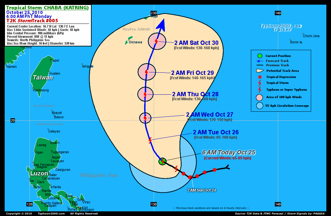
CURRENT STORM INFORMATION
Time/Date: 6:00 AM PhT Mon Oct 25 2010
Location of Center: 16.7º N Lat 130.7º E Lon
Distance 1: 780 km (420 nm) ENE of Virac, Catanduanes
Distance 2: 875 km (473 nm) ENE of Metro Naga/CWC
Distance 3: 920 km (497 nm) ENE of Casiguran, Aurora
Distance 4: 950 km (513 nm) ESE of Ilagan, Isabela
Distance 5: 1055 km (570 nm) ENE of Metro Manila
MaxWinds (1-min avg): 65 kph (35 kts) near the center
Peak Wind Gusts: 85 kph (45 kts)
Present Movement: NW @ 15 kph (08 kts)
Towards: Philippine Sea
24-hr Total Rainfall (near center): 490 mm (Heavy)
Minimum Central Pressure: 996 millibars (hPa)
Saffir-Simpson Typhoon Scale: TS
Size (in Diameter): 520 km (280 nm) / Average
Max Sea Wave Height (near center): 16 ft (4.8 m)
Possible Storm Surge Height: 1 ft [0.3 m]
T2K TrackMap #05 (for Public): 6 AM PhT Mon Oct 25
FORECAST OUTLOOK ANALYSIS (up to 48 hours)* EXTENDED FORECAST TRACK (3 to 5 days)*
CHABA is expected to continue moving NW-ward slowly for the next 24 hours and then turn sharply Northward as it becomes a Category 1 Typhoon on Wednesday. This system will continue to intensify as it moves across the warm waters of the North Philippine Sea [2AM OCT 26: 18.4N 129.7E @ 85kph...2PM OCT 26: 19.3N 129.4E @ 100kph...2AM OCT 27: 20.2N 129.3E @ 120kph].
Maximum Sustained Winds (1-min. avg) are near 65 km/hr (35 knots) with higher gusts. Tropical Storm Force Winds (62-85 km/hr) extend outward up to 55 kilometers (30 nautical miles) from the center. CHABA is an average-sized tropical cyclone with a diameter of 520 kilometers (280 nautical miles).  THURSDAY EARLY MORNING: CHABA continues to track north towards Okinawa-Ryukyus Area and intensify...about 790 km ENE of Itbayat, Batanes, PH [2AM OCT 28: 22.1N 129.3E @ 130kph]. FRIDAY EARLY MORNING: Still intensifying...starts to move NNE...nears Okinawa-Ryukyus Area...about 855 km NE of Itbayat, Batanes, PH [2AM OCT 29: 23.9N 129.4E @ 140kph]. SATURDAY EARLY MORNING: Exits the Philippines' Area of Forecasting Responsibility...passing just to the east of Okinawa...begins Extratropical transition...about 220 km East of Naha, Okinawa [2AM OCT 30: 26.4N 130.2E @ 130kph].
*Please be reminded that the Forecast Outlook changes every 6 hours, and the Extended Forecast Track have an average error of 250 km on Day 3...450 km on Day 4...and 650 km on Day 5, while the wind speed forecast error, averages 35 kph per day. Therefore, a turn to the left or right of its future track and changes in its wind speed must be anticipated from time to time.
EFFECTS & HAZARDS SUMMARY
CHABA's circulation has improved overnight with deep cloud convection wrapping into the center. Below are the summary of the cyclone's parts and its hazards affecting specific areas: CENTRAL DENSE OVERCAST (CDO) - currently developing...with a small area of Tropical Force Winds located near the center. (click here to know more about CDO). DEVELOPING RAINBANDS - continues to improve on all sides, except the northern and NE parts. Light to moderate winds (<35 kph) can be expected along the area today. (click here to know more about Rainbands). 24-HR TOTAL RAINFALL ACCUMULATION - from 5 up to 200 mm (light, moderate to heavy rain) can be expected along the developing rainbands...with isolated amounts of up to 490 mm (heavy) near the center of CHABA, especially the western and southern peripheries. [click to open NOAA's eTRaP graphic]. COASTAL STORM SURGE FLOODING - None (click here to know more about Storm Surge).
CURRENT ITCZ/MONSOON TROUGH INTENSITY: HIGH >> Mostly cloudy skies with isolated to scattered showers, rains & thunderstorms can be expected along these following affected areas: BICOL REGION, SOUTHERN LUZON AND THE VISAYAS. Light to moderate SW, South, SE winds (not in excess of 35 kph) can be expected today. The prevailing strong La Niña conditions over the Pacific Ocean enhances the ITCZ to be more active across the Philippines.
Important Note: Please keep in mind that the above forecast outlook, extended forecast, effects-hazards, current monsoon intensity, & tropical cyclone watch changes every 6 to 12 hrs!![]()
External Links for TS CHABA (KATRING)
View NOAA-CIRA's Latest Wind Analysis
JTWC Latest Tracking Chart: wp1610.gif
Multi-Agency Forecast TrackMap: Near Real-Time
TSR Wind Probabilities: Current to 120 hrs Ahead
NASA-JAXA TMI Page: Latest Rainrate 01
EORC-JAXA TRMM Page: Latest Rainrate 02
Zoomed Satellite Pic: NOAA's Near Real-Time
Wunderground Animation: 6-12 hr. GIF Loop
*TROPICAL STORM (TS) 16W (CHABA), LOCATED APPROXIMATELY 600 NM
SOUTH-SOUTHEAST OF KADENA AB, OKINAWA, JAPAN, HAS TRACKED
NORTHWESTWARD AT 09 KNOTS OVER THE PAST SIX HOURS. ANIMATED INFRARED
SATELLITE IMAGERY SHOWS IMPROVED DEEP CONVECTION ALONG THE SOUTHERN
PERIPHERY OF THE LOW LEVEL CIRCULATION CENTER (LLCC). THE INITIAL
POSITION IS BASED ON A 241713Z AMSRE 36H MICROWAVE IMAGE, WHICH
DEPICTS CURVED LOW LEVEL CONVECTIVE BANDING. THE INITIAL INTENSITY
IS BASED ON PGTW, KNES, AND RJTD DVORAK ESTIMATES OF 35 KNOTS.
ALTHOUGH EQUATORWARD OUTFLOW HAS IMPROVED, AN UPPER TROPOSPHERIC
TROUGH IS PREVENTING CONVECTIVE DEVELOPMENT ALONG THE NORTHERN
PERIPHERY OF THE LLCC AND IS HINDERING POLEWARD OUTFLOW. TS 16W HAS
TURNED NORTHWESTWARD IN RESPONSE TO A MID-LATITUDE, UPPER LEVEL
TROUGH MID-LEVEL REORIENTING THE MID-LEVEL SUBTROPICAL STEERING
RIDGE. A 241200Z UPPER AIR ANALYSIS INDICATES A MID-LATITUDE TROUGH
IS DIGGING SOUTHWARD OVER NORTHEASTERN CHINA. THE STEERING RIDGE IS
FORECAST TO CONTINUE TO RE-ORIENT AND WEAKEN WITH THE PASSING MID-
LATITUDE TROUGH, ALLOWING TS 16W TO TURN MORE POLEWARD OVER THE NEXT
48 HOURS. AROUND TAU 96, TS CHABA IS EXPECTED TO TURN NORTHEASTWARD
AS IT ROUNDS THE SUBTROPICAL RIDGE AXIS. POLEWARD OUTFLOW INTO THE
TROUGH SHOULD ALSO INCREASE, WHICH WILL SUPPORT INTENSIFICATION.
HOWEVER, AS THE SYSTEM TRACK BEGINS TO ROUND THE SUBTROPICAL RIDGE
AXIS, INCREASED VERTICAL WIND SHEAR ASSOCIATED WITH THE MID-
LATITUDES AS WELL AS LOWER OCEAN HEAT CONTENT SHOULD INITIALLY
WEAKEN TS 16W AS IT BEGINS EXTRATROPICAL TRANSITION. NUMERICAL MODEL
GUIDANCE IS IN FAIR AGREEMENT WITH THE TIMING OF THE TURN NORTHWARD
AND NORTHEASTWARD, EXCEPT FOR GFDN WHICH ERRONEOUSLY INTENSIFIES TS
16W AND TRACKS IT WESTWARD. THE MAJORITY OF THE MODELS ARE
INDICATING A TURN TO THE NORTHEAST AROUND TAU 72 TO 96. NOGAPS
TRACKS THE SYSTEM FURTHEST NORTHWARD AND TURNS THE SYSTEM JUST SOUTH
OF OKINAWA, JAPAN. ECMWF, GFS, EGRR, AND WBAR PULL TS CHABA
NORTHEASTWARD BELOW 24N DEGREES LATITUDE, INDICATING THE MID-
LATITUDE TROUGH WILL BE DEEP ENOUGH TO INDUCE A RECURVATURE
SCENARIO. THIS FORECAST IS IN AGREEMENT WITH THIS SCENARIO BASED ON
THE MAJORITY OF THE MODELS...(more)
>> CHABA, meaning: Tropical flower (the shoeflower, genus hibiscus). Name contributed by: Thailand.
RECENT TYPHOON2000.COM TRACKING CHART:
RECENT MULTI-AGENCY TROPICAL CYCLONE FORECAST TRACKING CHART:


> Image source: NOAA SATELLITE CENTER
> Image source: Wunderground.com (http://www.wunderground.com/)
____________________________________________________________________________________________________________________
LATEST 24 HR. TOTAL RAINFALL AMOUNTS / ENSEMBLE TROPICAL RAINFALL POTENTIAL (eTRaP):

> Image source: NOAA Satellite & Information Service (http://www.ssd.noaa.gov/PS/TROP/etrap.html)
>> To know the meteorological terminologies and acronyms used on this update visit the ff:
http://typhoon2000.ph/tcterm.htm
http://www.nhc.noaa.gov/aboutgloss.shtml
http://www.srh.noaa.gov/oun/severewx/glossary.php
http://www.srh.weather.gov/fwd/glossarynation.html
http://www.nhc.noaa.gov/acronyms.shtml
__________________________________________________________________________________________
For the complete details on TS CHABA (KATRING)...go visit our website @:
> http://www.typhoon2000.com
> http://www.maybagyo.com
Copyright © 2010 Typhoon2000.com All Rights Reserved

No comments:
Post a Comment